Local events in Castalia
Castalia itself has 2 events posted in the next 90 days; the others here are within 10 miles. All local events in Castalia
Checked October 20; the events page is refreshed daily.
Deep dives about Castalia
Long reads built from maps, newspapers and public records. All deep dives
How Castalia began
Castalia was laid out in 1836 at the center of Margaretta Township and named for Castalia, a figure in Greek mythology. The village sits on or near the site of Junundat, a Wyandot village founded around 1740 that was abandoned by its own people in the late 1740s and later destroyed by British troops during Pontiac's War in 1763. In the 19th century Castalia was also the birthplace of Carrie Chase Davis, born in 1863 on a nearby farm her father ran partly as an Underground Railroad station, who became a physician and was recording secretary of the Ohio Woman Suffrage Association.
Platted 1836.
Where the name comes from
Named after Castalia, a figure in Greek mythology, according to Wikipedia.
Before the town
A Wyandot village called Junundat stood near present Castalia, founded around 1740 (Castalia's own Wikipedia entry gives 1738) by a faction led by Nicholas Orontony, who had returned to the Sandusky Bay area with his followers to trade more cheaply with the British than the French allowed. After plotting against and killing French traders, Orontony's people burned Junundat themselves and relocated -- south to a village called Conchake per the Junundat article, or to the mouth of the Cuyahoga River (Cleveland) per Castalia's own entry, with the two sources disagreeing on both the exact year (1747 vs. 1748) and the destination. Whatever Wyandot remained at or returned to the site were finally driven off in July 1763, when British captain James Dayell destroyed Junundat during Pontiac's War.
Nations recorded here: Wyandot.
- Junundat (village) — near or at present Castalia (exact location uncertain), c. 1738/1740-1763 (en.wikipedia.org)
Timeline
- — A Wyandot faction led by Nicholas Orontony founded the village of Junundat at or near the site of present Castalia.
- — Orontony's faction burned Junundat and relocated, after killing French traders in a regional plot; sources disagree on whether the year was 1747 or 1748 and whether the destination was Conchake or the mouth of the Cuyahoga River.
- — British captain James Dayell destroyed Junundat during Pontiac's War.
- — D. P. Snow built a log mill and the first house at the head of Cold Creek, the settlement later called Castalia; by 1813 there were only three houses, Snow's, Butler's and Putnam's.
- — Dr. B. L. Carpenter built a small distillery at the head of Cold Creek, which was abandoned about 1830.
- — Castalia was laid out; Wikipedia says it was named after Castalia, a figure in Greek mythology.
- — A cotton factory was built at Castalia, and in 1864 John Hoyt converted it into the Castalia Paper Company, which burned in 1874.
- — The Methodists built a frame church at Castalia, which had no regular services after 1860; a Universalist church was organized October 12, 1862 and built in 1867.
- — Carrie Chase Davis, future physician and suffragist, was born on a farm near Castalia to a father who was a leading local farmer and had run an Underground Railroad station.
- — John Hoyt began the effort to raise brook trout in the pond at the head of Cold Creek and, after two failures, succeeded.
- — Local men incorporated the Castalia Milling Company and bought the water power for $8,000, building a three-story flouring mill of 125 barrels a day.
- — The Ohio legislature incorporated the Cold Creek Trout Club, which had seventy-four members, leased the headwaters for twenty years and in 1887, renamed the Cold Creek Sporting Club, bought the property for $20,000.
- — The census counted 117 residents.
- — The Blue Hole spring operated as a tourist attraction, at its peak drawing an estimated 165,000 visitors a year.
- — The census counted 1,045 residents, the highest ever recorded, against 774 in 2020.
Stories
From an Underground Railroad farm to a medical degree
Carrie Chase Davis was born August 13, 1863, on a farm near Castalia where her father, Thomas Robert Davis, was known as a leading area farmer and stock raiser and had run a station on the Underground Railroad. She left Ohio to teach school in Kansas from 1887 to 1893, then turned to medicine, graduating from Howard University's College of Medicine in 1897 with a specialty in bacteriology and completing a residency at a Philadelphia charity hospital before opening her own practice in Sandusky in 1899. She practiced there for the following decade, serving as secretary of the Erie County Medical Society and joining the Ohio State and American Medical Associations, while also becoming recording secretary of the Ohio Woman Suffrage Association and president of the Civic Club of Sandusky. She died in Tennessee in 1953 at 89, having willed her body to Vanderbilt University's medical school.
The trout club at Cold Creek
In 1870 John Hoyt, who owned the Castalia paper mills, tried a few thousand brook trout eggs in troughs at the head of Cold Creek; a thunderstorm killed the first brood and the second was reportedly poisoned by the keeper, but the third batch turned loose in the pond multiplied. In May 1878 the Ohio legislature chartered the Cold Creek Trout Club to fish, hunt and propagate fish on land leased from the Castalia Milling Company for fifty dollars a year. Seventy-four members, shares of fifteen dollars, built a clubhouse in 1883 and bought forty acres with buildings in 1887 for $20,000, by which time the shares were worth $300 each. By then the old mill had been moved away, the stream was a trout stream, a hatchery held forty thousand baby trout, and a bridge joined the clubhouse to the keeper's house. The county historian called it an ideal sportsman's paradise.
Photographs
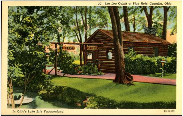
Photo: Columbus Metropolitan Library, via Digital Public Library of America / Ohio Digital Network, no known copyright restrictions · Wikimedia Commons
Local history sources: en.wikipedia.org · en.wikipedia.org · en.wikipedia.org · commons.wikimedia.org · archive.org · commons.wikimedia.org
Water
Lake Erie, drawn through a 42-inch gravity pipe about three-quarters of a mile offshore near Cedar Point Chaussee, with a Sandusky Bay intake used as backup The water here
- Erie Co. Margaretta District100% of residentsLake Erie (Sandusky Bay backup intake)
Hospitals, fire stations and more
Inside Castalia's boundary: 1 fire or EMS station and 2 public schools. Press a pin or a name for its whole record and its source.
Fire and EMS stations (1)
-
Margaretta Township Fire DepartmentCastalia
- Address
- 113 South Avenue, Castalia, OH 44824
- Coordinates
- 41.39971, -82.80776
USGS National Map structures (source) ↗ Street map and directions ↗
Source: USGS National Map structures (most Ohio records last updated 2019 to 2022), checked against the Columbus and Cleveland station lists. The department that answers a call is set by jurisdiction and mutual aid, not by distance.
Public schools (2)
-
Margaretta High School4 of 5 stars · Castalia
- Address
- 209 Lowell St, Castalia, OH 44824
- School district
- Margaretta Local School District
- Kind (NCES)
- Regular School
- Students, 2023-24
- 540
- Teachers (full-time equivalent)
- 32
- Report card, 2025-26
- 4 of 5 stars
- Performance index
- 81.2%
- Four-year graduation rate
- 98.8%
- Ohio building IRN
- 022764
- NCES school ID
- 390468002658
NCES school record ↗ Ohio School Report Card ↗ Street map and directions ↗
-
Townsend Community SchoolCastalia
- Address
- 207 Lowell St, Castalia, OH 44824
- Kind (NCES)
- Regular School
- Students, 2023-24
- 499
- Teachers (full-time equivalent)
- 14.3
- NCES school ID
- 390145005693
Source: NCES EDGE public school locations 2024-25 and Common Core of Data 2023-24 (type, students, teachers); Ohio School Report Cards 2025-26 (Department of Education and Workforce), matched by name within the district.
Its ZIP codes
Each ZIP code that touches Castalia, with the share of its residents who live here and the same headline figures as the ZIP page.
| ZIP | Share | Water | Radon | Home value | Schools | Flood |
|---|---|---|---|---|---|---|
| 44824 Margaretta Township and Castalia | 20% | Lake Erie, drawn through a 42-inch gravity pipe about three-quarters of a mile offshore near Cedar Point Chaussee, with a Sandusky Bay intake used as backup | 8.1 pCi/L average radon | Median year built 1970 | Margaretta Local · 4 stars overall | 0.5% of residents in the 1% floodplain |
Local government
Who holds office in Castalia, how its elections and ballot issues came out, and the state auditor's record.
Money issues on the ballot since 2017: 3 of 4 passed; of those asking for new or higher taxes, 1 of 2.
Ballot issues
| Date | Issue | For | Against | Result |
|---|---|---|---|---|
| 2022-05-03 | 2: 2 Castalia Village Additional Levy, Roads, 2.75 mills, 5 yrs, commencing in 2022, first due in (2.75 mills, additional) | 105 | 67 | Passed (61.05% for) |
| 2020-11-03 | 7: #7 Castalia Village Tax Levy (Roads) | 317 | 82 | Passed (79.45% for) |
| 2019-11-05 | 15: 15 Castalia Village Tax Levy (Current Expenses) | 163 | 36 | Passed (81.91% for) |
| 2017-11-07 | 8: #8 Castalia Village Tax Levy Additional Current Expenses | 102 | 118 | Failed (46.36% for) |
Auditor of State record
- No fiscal caution, watch or emergency on the Auditor of State's lists.
- Financial Audit, 2023 to 2024, released 2026-03-03
The county
Erie County: 7 ZIP codes, 15 cities, villages and townships, 78,997 people.
Nearby places
Rain and snow
How much has actually fallen on Castalia, day by day, from 1893 to now. Daily totals, not averages.
- rain, last 30 days
- 2.01 in
- 2026-09-29 to 2026-10-28
- rain so far in 2026
- 36.8 in
- 6.5 in above normal for the date
- snow so far in 2026
- 24.0 in
- a normal year brings 27.5 in
- a normal year
- 35.4 in
- average of 30 years, 1991-2020
| Month | Rain (in) | Snow (in) | Days counted |
|---|---|---|---|
| October 2026 | 2.01 | — | 28 |
| September 2026 | 2.76 | — | 30 |
| August 2026 | 5.27 | — | 31 |
| July 2026 | 4.59 | — | 31 |
| June 2026 | 7.02 | — | 30 |
| May 2026 | 4.16 | — | 31 |
| April 2026 | 6.74 | — | 30 |
| March 2026 | 3.19 | — | 31 |
| February 2026 | 0.29 | 4.9 | 28 |
| January 2026 | 0.77 | 19.1 | 31 |
| December 2025 | 1.50 | 5.7 | 31 |
| November 2025 | 1.44 | 0.1 | 30 |
| Wettest year | 2011 — 55.0 in |
|---|---|
| Driest year | 1963 — 18.8 in |
| Snowiest year | 2014 — 65.9 in |
| Wettest day on record | 5 July 1969 — 6.16 in |
| Heaviest snowfall in a day | 23 December 2004 — 13.30 in |
| Deepest snow on the ground | 1 February 1978 — 23.74 in |
Estimated, not measured. No rain gauge has ever stood inside Castalia, so every figure here is worked out from the gauges around it - the nearest ones weighted most. Treat them as close estimates rather than readings.
48,691 days of records, 1893-04-01 to 2026-10-28. Source: NOAA NCEI GHCN-Daily, 3,240 gauges in and around Ohio. A day is "gauged" when a gauge standing inside the boundary reported it, and the value is the mean of those gauges. Otherwise it is interpolated by inverse distance from every gauge reporting within 50 miles. Nothing is carried forward, back-filled or smoothed. Against NOAA nClimDiv county monthly precipitation over 136,848 complete county-months (checked 2026-10-31): correlation 0.9515, median absolute difference 0.217 in a month. Built 2026-10-31 from the Cracked Buckeye precipitation archive. Snow is the softer number — snowfall is measured by hand with a ruler, no agency publishes a gridded county snowfall series, and blowing snow defeats every observer.
Environmental permits and filings
What Ohio EPA has on file for Castalia: permits, inspections, violations, cleanups and the state loans behind sewer and water work. Every line links to the agency's own document.
- facilities and sites on file
- 2
- those placed on the map inside Castalia
| Program | Facilities and sites |
|---|---|
| Brownfield | 1 |
| Hazardous waste | 1 |
| Date | Facility or site | What |
|---|---|---|
| VILLAGE STATION | Brownfield assessment |
Source: Ohio EPA eDocument portal (edocpub.epa.ohio.gov), indexed 2026-10-14. Facilities are placed on the map from Ohio EPA's own map layers, EPA's Facility Registry, coordinates written in the filings, or a geocoded street address. A permit filed under a private person's name (most are household septic systems) is counted but never named, placed or linked; licenses for individual workers and open-burning notices are left out entirely.
Quick answers
What county is Castalia, Ohio in?
Castalia is a village in Erie County, Ohio, with 774 residents.
When was Castalia, Ohio founded?
Castalia was laid out 1836. Source
How did Castalia, Ohio get its name?
Named after Castalia, a figure in Greek mythology, according to Wikipedia. Source
What ZIP code is Castalia, Ohio?
Most of Castalia is in ZIP code 44824.
Where does Castalia, Ohio get its water?
The main water source for Castalia (Erie Co. Margaretta District): Lake Erie, drawn through a 42-inch gravity pipe about three-quarters of a mile offshore near Cedar Point Chaussee, with a Sandusky Bay intake used as backup.
Cite this page
Cite this page as:
Cracked Buckeye, "Castalia, Erie County", https://crackedbuckeye.com/place/castalia/, built 2026-10-31, accessed [date].
How to cite · Report a correction · Built 2026-10-31
