Local events in Butlerville
Nothing is posted for Butlerville itself yet; here is what is on within 10 miles. All local events in Butlerville
Know a calendar we should watch? Send the link
Checked October 20; the events page is refreshed daily.
How Butlerville began
Butlerville is a small village in central Harlan Township, Warren County, Ohio, platted in 1838 along a new turnpike being built between Goshen, Wilmington and Columbus. It was named for its founder, Abram B. Butler, who added to the plat twice more in 1839 and 1841; a further addition called "Texas" was platted south of it in 1844 by J. W. Doughman. The village incorporated in 1851 and by the 1880s supported a hotel, general stores, a tannery, a carriage and wagon works, and two successive Methodist Episcopal churches, the second of which (built 1857) still stands. It remains a very small residential village today, population 137 to 155 depending on the count, sitting within the historic Western Water Company service area.
Platted 1838, incorporated 1851, by Abram B. Butler.
Where the name comes from
Butlerville was named for its founder and original proprietor, Abram B. Butler, who platted the town on April 20, 1838 along the route of the Goshen, Wilmington and Columbus Turnpike as it was being built, then added to it on September 8, 1839 and May 17, 1841.
Before the town
No Native American village, trail, mound, or documented encounter specific to Butlerville itself was found in the sources searched (Beers' 1882 county history, GNIS, Wikipedia, Ohio History Central). General county- and region-level context: Warren County holds major Hopewell-era (about 100 BC to AD 500) earthworks on the Little Miami River, including Fort Ancient (Washington Township, about 11 km from Butlerville) and the Stubbs Earthworks near Morrow, part of the Hopewell Ceremonial Earthworks UNESCO World Heritage designation (2023). Centuries after the Hopewell builders, a distinct later Fort Ancient culture (roughly AD 1000-1750) occupied village sites in the same Little Miami valley region, including within the old Hopewell embankments at the Fort Ancient site itself. In the historic period, the Ohio Country lands east of the Greenville Treaty Line -- which includes the Little Miami/Great Miami valley area where Warren County lies -- were ceded to the United States by a coalition of nations (Wyandot, Shawnee, Lenape/Delaware, Ottawa, Chippewa, Potawatomi, Miami, and others) under the Treaty of Greenville, signed August 3, 1795, opening the area to the surveying and settlement that produced Harlan Township and, later, Butlerville. No source found assigns a specific historic-period village, camp, or named site to Harlan Township or Butlerville itself.
Nations recorded here: Shawnee, Wyandot, Lenape (Delaware), Miami, Ottawa, Hopewell culture, Fort Ancient culture.
- Fort Ancient (earthwork) — Washington Township, Warren County, on the Little Miami River, about 11 km southeast of Butlerville, Hopewell culture (1st century BC - 6th century AD), later occupied by the separate Fort Ancient culture (c. AD 1000-1750) (en.wikipedia.org)
- Stubbs Earthworks (earthwork) — near Morrow, Warren County, at the confluence of the Little Miami River and Todd Fork/Bigfoot Run, Hopewell culture (100 BC - AD 500) (en.wikipedia.org)
Timeline
- — Abram B. Butler platted Butlerville on April 20, along the new Goshen, Wilmington and Columbus Turnpike in Harlan Township, Warren County.
- — A post office named "Rossburgh" was established in Harlan Township on December 7, with Jefferson Stevens as postmaster; it was renamed Butlerville ten days later, on December 17 (Wikipedia gives 1833 for the post office).
- — Butler added to the original plat on September 8; a Methodist Episcopal frame church was also built on Back Street around this year.
- — Butler made a further addition to the plat on May 17.
- — Hiram St. John began a carriage and wagon manufacturing business in the village.
- — J. W. Doughman platted an addition south of the village, named "Texas," on November 19.
- — Henry Runyan established a plow and wagon factory in Butlerville in September.
- — Butlerville incorporated as a village, the only incorporated village in Harlan Township; Sullivan F. Stevens was elected its first mayor on March 11.
- — A brick Methodist Episcopal church was built on Main Street, replacing the 1839 frame church; it still stands as the Butlerville United Methodist Church.
- — The village tannery, run successively by J. St. John, William Spence, and John Morsback, was abandoned this year.
- — The Butlerville post office was discontinued on March 22; its records and papers were transferred to the post office at Blanchester, Clinton County, on April 15.
Stories
A turnpike town, twice named
Butlerville began less as a settlement that grew into a town than as a real-estate move timed to a road project: in 1838, as the Goshen, Wilmington and Columbus Turnpike was being pushed through Harlan Township, landowner Abram B. Butler platted 24 lots along its path and put his own name on them. He was not finished -- he filed two more additions to the plat within the next three years, in 1839 and 1841, and a neighbor, J. W. Doughman, tacked on a further section to the south in 1844 that he called "Texas," evidently after the republic much in the news that year. The village's post office tells the same story of a plan still being finalized: opened that same December of 1838, it briefly bore the name "Rossburgh" before being renamed Butlerville just ten days later, with Jefferson Stevens carrying the postmastership across the change. By 1851 the place had enough residents and enough confidence in itself to incorporate, with Sullivan F. Stevens elected its first mayor -- the only incorporated village Harlan Township would ever have.
Photographs
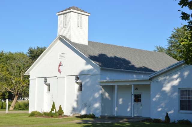
Photo: Nyttend, public domain · Wikimedia Commons
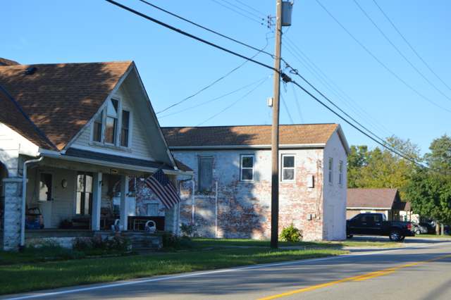
Photo: Nyttend, public domain · Wikimedia Commons
Local history sources: en.wikipedia.org · warren.ohgenweb.org · warren.ohgenweb.org · commons.wikimedia.org · commons.wikimedia.org · commons.wikimedia.org · en.wikipedia.org · en.wikipedia.org · en.wikipedia.org
Water
Ohio River intake at the plant's riverfront on Kellogg Ave in the California neighborhood, east Cincinnati The water here
- Western Water Company100% of residentsLittle Miami River valley wells (51%) plus Cincinnati Ohio River water (49%)
Its ZIP codes
Each ZIP code that touches Butlerville, with the share of its residents who live here and the same headline figures as the ZIP page.
| ZIP | Share | Water | Radon | Home value | Schools | Flood |
|---|---|---|---|---|---|---|
| 45162 Harlan Township and Pleasant Plain | 5% | Ohio River intake at the plant's riverfront on Kellogg Ave in the California neighborhood, east Cincinnati | 4.4 pCi/L average radon | Appraisal records without year built | Little Miami Local · 4.5 stars overall | 3.4% of residents in the 1% floodplain |
Local government
Who holds office in Butlerville, how its elections and ballot issues came out, and the state auditor's record.
Elections for office
| Date | Office | Candidates and votes |
|---|---|---|
| 2015-11-03 | Member of Council | Tony Bitzer 30, 54.55%; Nathan Adkins 25, 45.45% |
| 2015-11-03 | Clerk-Treauser | Susan Bitzer 37, 100.0% |
Winners in bold. Results from the county board of elections' official canvass unless marked.
Auditor of State record
- No fiscal caution, watch or emergency on the Auditor of State's lists.
- Basic Audit, 2023 to 2024, released 2025-08-26
The county
Warren County: 12 ZIP codes, 24 cities, villages and townships, 222,825 people.
Nearby places
Rain and snow
How much has actually fallen on Butlerville, day by day, from 1893 to now. Daily totals, not averages.
- rain, last 30 days
- 0.99 in
- 2026-09-30 to 2026-10-29
- rain so far in 2026
- 45.3 in
- 6.1 in above normal for the date
- snow so far in 2026
- 16.8 in
- a normal year brings 17.6 in
- a normal year
- 46.0 in
- average of 30 years, 1991-2020
| Month | Rain (in) | Snow (in) | Days counted |
|---|---|---|---|
| October 2026 | 0.99 | — | 29 |
| September 2026 | 7.65 | — | 30 |
| August 2026 | 6.65 | — | 31 |
| July 2026 | 3.91 | — | 31 |
| June 2026 | 5.19 | — | 30 |
| May 2026 | 6.31 | — | 31 |
| April 2026 | 4.17 | — | 30 |
| March 2026 | 7.52 | 0.4 | 31 |
| February 2026 | 1.23 | 5.2 | 28 |
| January 2026 | 1.64 | 11.3 | 31 |
| December 2025 | 2.81 | 11.2 | 31 |
| November 2025 | 3.87 | 2.7 | 30 |
| Wettest year | 2011 — 64.5 in |
|---|---|
| Driest year | 1934 — 21.6 in |
| Snowiest year | 1977 — 46.0 in |
| Wettest day on record | 6 October 1910 — 4.99 in |
| Heaviest snowfall in a day | 23 December 2004 — 12.52 in |
| Deepest snow on the ground | 25 January 1894 — 20.00 in |
Estimated, not measured. No rain gauge has ever stood inside Butlerville, so every figure here is worked out from the gauges around it - the nearest ones weighted most. Treat them as close estimates rather than readings.
48,637 days of records, 1893-01-01 to 2026-10-29. Source: NOAA NCEI GHCN-Daily, 3,240 gauges in and around Ohio. A day is "gauged" when a gauge standing inside the boundary reported it, and the value is the mean of those gauges. Otherwise it is interpolated by inverse distance from every gauge reporting within 50 miles. Nothing is carried forward, back-filled or smoothed. Against NOAA nClimDiv county monthly precipitation over 136,848 complete county-months (checked 2026-10-31): correlation 0.9515, median absolute difference 0.217 in a month. Built 2026-10-31 from the Cracked Buckeye precipitation archive. Snow is the softer number — snowfall is measured by hand with a ruler, no agency publishes a gridded county snowfall series, and blowing snow defeats every observer.
Quick answers
What county is Butlerville, Ohio in?
Butlerville is a village in Warren County, Ohio, with 137 residents.
When was Butlerville, Ohio founded?
Butlerville was laid out 1838; incorporated 1851. Founders on record: Abram B. Butler. Source
How did Butlerville, Ohio get its name?
Butlerville was named for its founder and original proprietor, Abram B. Source
What ZIP code is Butlerville, Ohio?
Most of Butlerville is in ZIP code 45162.
Where does Butlerville, Ohio get its water?
The main water source for Butlerville (Western Water Company): Ohio River intake at the plant's riverfront on Kellogg Ave in the California neighborhood, east Cincinnati.
Cite this page
Cite this page as:
Cracked Buckeye, "Butlerville, Warren County", https://crackedbuckeye.com/place/butlerville/, built 2026-10-31, accessed [date].
How to cite · Report a correction · Built 2026-10-31
