Local events in Brookville
39 events in the next 90 days from 2 public calendars. All local events in Brookville
Checked October 20; the events page is refreshed daily.
How Brookville began
Brookville, in the far northwest corner of Montgomery County along Wolf Creek, traces to a handful of pioneer families who settled there around 1814. The city dates its establishment to 1832; the town was platted in 1850 and named for a small brook near the town site, and grew slowly until the Wolf Creek Turnpike opened between Dayton and Brookville in 1844. It incorporated as a village on September 9, 1874. Records of its early decades are thin next to Dayton's larger suburbs; what survives centers on its churches, schools, and the Queen Anne house of a local plumber, Samuel Spitler, now the home of the Brookville Historical Society.
Settled c. 1814, platted 1850, incorporated September 9, 1874.
Where the name comes from
Brookville was named for a small brook running near the town site, according to William D. Overman's 'Ohio Town Names' (1958), cited by the Wikipedia article. No source consulted found a documented earlier name for the settlement — a claim seen in one low-quality web listing that the town was first called 'Watervliet' could not be verified against any primary or scholarly source and appears to confuse Brookville with the unrelated Watervliet Shaker Village, which stood in what is now Kettering, elsewhere in Montgomery County; that claim is not repeated here.
Before the town
No known source names a specific Native village, camp, trail or burial site within present-day Brookville. The town sits in the Wolf Creek valley in far northwestern Montgomery County; Wolf Creek itself rises northwest of Brookville and was named by pioneers for the wolves they encountered there, which is itself indirect evidence of how little-traveled the area still was when European-American settlement began around 1814 — nineteen years after the 1795 Treaty of Greenville opened this part of Ohio to survey. In the wider Great Miami valley through Montgomery County, the mid-to-late 1700s were a stronghold period for the Myaamia (Miami) and Shawnee nations, the Shawnee having resettled into the region under earlier pressure from the Iroquois wars of the mid-1600s; both nations were pushed out of Ohio entirely by the 1830s. No source ties either nation's villages specifically to the Wolf Creek headwaters near Brookville. For the county-wide picture of peoples, treaties and removal.
Nations recorded here: Shawnee, Miami.
Timeline
- — The first pioneer families settled the ground that became Brookville.
- — The town was platted on April 13 and named Brookville, for a small brook near the town site; the city dates its establishment to 1832.
- — The Wolf Creek Turnpike opened between Dayton and Brookville, and the community began to grow in earnest.
- — Brookville incorporated as a village, on September 9.
- — Plumber Samuel Spitler had the Queen Anne house at 15 Hay Avenue built by local craftsman Warren Rasor; Spitler is credited with installing Brookville's first indoor bathroom.
- — The Spitler House was listed on the National Register of Historic Places, September 28; the Brookville Historical Society formed the same year to save it from demolition.
- — The Spitler House was moved from its original site at 15 Hay Avenue to its present location, becoming the Brookville Community Museum and Historical Society.
Stories
The plumber's house that became the town's museum
Samuel Spitler was a self-taught plumber in a small farm town, not a man of obvious means, but in 1894 he had a striking Queen Anne house built for himself at 15 Hay Avenue by a local craftsman, Warren Rasor. Spitler is remembered locally for installing Brookville's first indoor bathroom, in his own home, at a time when that was still a rarity even in bigger towns nearby. The house passed out of family hands and stood in the way of demolition decades later, but a group of residents organized to save it, forming the Brookville Historical Society in 1973. The National Register of Historic Places listed the house that same September, and in 1974 the Society had it physically moved to its present site rather than lose it. It now serves as the Brookville Community Museum, a small-town preservation story built around one plumber's fine house.
Photographs
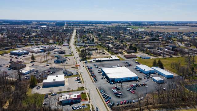
Photo: Logan Rickert, CC BY 2.0 · Wikimedia Commons
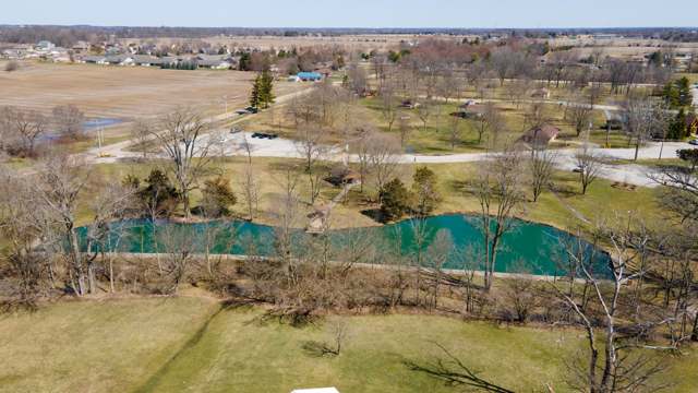
Photo: Logan Rickert, CC BY 2.0 · Wikimedia Commons
Local history sources: en.wikipedia.org · brookvilleohio.com · brookvillehistory.org · en.wikipedia.org · en.wikipedia.org · mcdwater.org · commons.wikimedia.org · commons.wikimedia.org
Historic places
1 place in Brookville on the National Register of Historic Places. Press a pin or a name for its whole record.
-
Spitler, Samuel, HouseBuilding · Brookville · listed 1973
- Address
- 14 Market St.
- Where
- Brookville, Montgomery County · ZIP 45309
- What it is
- Building
- Listed on the National Register
- 1973
- NRIS reference number
- 73001507
- Coordinates
- 39.83564, -84.41381
National Register file (NPS) ↗ Search Wikipedia ↗ Street map and directions ↗ On the Cracked Buckeye map
Source: National Park Service, National Register of Historic Places point file. The listing year is shown where NPS's certification date agrees with the listing's reference number. Listing recognizes significance; it does not restrict a private owner.
Water
Mad River Well Field wells along the Mad River east of Dayton, refilled by river water let into recharge lagoons The water here
- Brookville Municipality95% of residentsGreat Miami Buried Valley Aquifer wells (recharged by Great Miami & Mad Rivers)
- Montgomery County Water Services 24% of residentsGreat Miami Buried Valley Aquifer wells (recharged by Great Miami & Mad Rivers)
- Phillipsburg Village1% of residentsGroundwater wells (4 wells)
Hospitals, fire stations and more
Inside Brookville's boundary: 1 nursing home, 1 fire or EMS station, 3 public schools, 1 poor-rated bridge, 1 library, 1 museum, 1 police station, 2 public charging sites, 6 Toxics Release Inventory facilities and 4 spill cases. Press a pin or a name for its whole record and its source.
Nursing homes (1)
-
Brookhaven Nursing & Rehabilitation Center5 of 5 stars · Brookville
- Address
- One Country Lane, Brookville, OH 45309
- Certified beds
- 99
- Residents on an average day
- 94
- Medicare overall rating
- 5 of 5 stars
- Health inspections
- 4 of 5 stars
- Staffing
- 4 of 5 stars
- Quality measures
- 5 of 5 stars
- Penalties since 2023
- none
- Ownership
- For profit - Individual
- Chain
- UNITED CHURCH HOMES
- Continuing care retirement community
- Yes
- Takes
- Medicare and Medicaid
- Phone
- (937) 833-2133
- Medicare ID
- 365422
Medicare Care Compare ↗ CMS nursing home data (source) ↗ Street map and directions ↗
Source: CMS Care Compare nursing home provider and penalties files; Medicare star ratings run 1 to 5.
Fire and EMS stations (1)
-
Brookville Fire Department Station 76Brookville
- Address
- 775 East Upper Lewisburg Salem Road, Brookville, OH 45309
- Coordinates
- 39.84559, -84.40987
USGS National Map structures (source) ↗ Street map and directions ↗
Source: USGS National Map structures (most Ohio records last updated 2019 to 2022), checked against the Columbus and Cleveland station lists. The department that answers a call is set by jurisdiction and mutual aid, not by distance.
Public schools (3)
-
Brookville Elementary School4.5 of 5 stars · Brookville
- Address
- 3 Blue Pride Dr, Brookville, OH 45309
- School district
- Brookville Local School District
- Kind (NCES)
- Regular School
- Students, 2023-24
- 502
- Teachers (full-time equivalent)
- 31.22
- Report card, 2025-26
- 4.5 of 5 stars
- Performance index
- 88.7%
- Ohio building IRN
- 040600
- NCES school ID
- 390486703343
NCES school record ↗ Ohio School Report Card ↗ Street map and directions ↗
-
Brookville High School4 of 5 stars · Brookville
- Address
- 1 Blue Pride Drive, Brookville, OH 45309
- School district
- Brookville Local School District
- Kind (NCES)
- Regular School
- Students, 2023-24
- 416
- Teachers (full-time equivalent)
- 24.9
- Report card, 2025-26
- 4 of 5 stars
- Performance index
- 82.6%
- Four-year graduation rate
- 98.4%
- Ohio building IRN
- 003863
- NCES school ID
- 390486703341
NCES school record ↗ Ohio School Report Card ↗ Street map and directions ↗
-
Brookville Intermediate School4.5 of 5 stars · Brookville
- Address
- 2 Blue Pride Drive, Brookville, OH 45309
- School district
- Brookville Local School District
- Kind (NCES)
- Regular School
- Students, 2023-24
- 609
- Teachers (full-time equivalent)
- 34.05
- Report card, 2025-26
- 4.5 of 5 stars
- Performance index
- 86.7%
- Ohio building IRN
- 043380
- NCES school ID
- 390486703342
NCES school record ↗ Ohio School Report Card ↗ Street map and directions ↗
Source: NCES EDGE public school locations 2024-25 and Common Core of Data 2023-24 (type, students, teachers); Ohio School Report Cards 2025-26 (Department of Education and Workforce), matched by name within the district.
Bridges rated poor (1)
-
Mckinley Street over Wolf CreekPoor · built 1979
- Condition
- Poor: a deck, superstructure, substructure or culvert rated 4 or below on the 0 to 9 scale
- What it is
- Bridge
- Built
- 1979
- Length
- 16 ft
- Owner
- City
- Vehicles a day
- 386
- Coordinates
- 39.83379, -84.41387
National Bridge Inventory (source) ↗ Street map and directions ↗
Source: FHWA National Bridge Inventory 2025. "Poor" means one major part rated 4 or below on the 0 to 9 scale; it calls for repair, not closing, unless the state posts or closes the bridge.
Public libraries (1)
-
Brookville Branch LibraryBranch · Brookville
- Address
- 120 Blue Pride Dr., Brookville, OH 45309
- What it is
- Branch
- Library system
- Dayton Metro Library
- Open
- 3,042 hours a year, 52 weeks
- Building
- 12,177 sq ft
- System's visits, FY2024
- 1,987,700
- System's loans, FY2024
- 4,831,439
- People the system serves
- 452,238
- Phone
- (937) 463-2665
IMLS Public Libraries Survey (source) ↗ Street map and directions ↗
Source: IMLS Public Libraries Survey FY2024 (outlets and their systems). Any Ohio resident can get a free card at any Ohio public library.
Museums, historical societies, gardens and zoos (1)
-
Brookville Historical SocietyHistorical society · Brookville
- What it is
- Historical society
- City
- Brookville
- Coordinates
- 39.83575, -84.41407
Search Wikipedia ↗ IMLS Museum Data Files (source) ↗ Street map and directions ↗
The museum list is IMLS's 2018 file; a museum may have closed or moved since.
Source: IMLS Museum Data Files, 2018.
Police stations (1)
-
Brookville Police DepartmentBrookville
- Address
- 301 Sycamore Street, Brookville, OH 45309
- Coordinates
- 39.83489, -84.40903
USGS National Map structures (source) ↗ Street map and directions ↗
Source: USGS National Map structures, police stations, corrected and completed by hand (September 2026). The department that answers a call is set by jurisdiction, not by distance.
Public EV charging (2)
-
McDonald's 40 Triggs Rd DC fast4 DC fast · Brookville
- Address
- 40 Triggs Rd., Brookville, OH 45309
- Ports
- 4 DC fast
- Plugs
- CCS, CHAdeMO
- Network
- eVgo Network
- Hours
- 24 hours daily
- Phone
- 877-455-3833
Station Locator (NREL) ↗ Alternative Fuels Data Center (source) ↗ Street map and directions ↗
-
MVRPC(EV#3)2 Level 2 · Brookville
- Address
- East Upper Lewisburg Salem Road, Brookville, OH 45309
- Ports
- 2 Level 2
- Plugs
- J1772
- Network
- Blink Network
- Hours
- 24 hours daily
- Phone
- 888-998-2546
Station Locator (NREL) ↗ Alternative Fuels Data Center (source) ↗ Street map and directions ↗
Source: NREL Alternative Fuels Data Center station list (May 2026), public and open stations, the posts at one address counted as one site.
Facilities reporting toxic releases (6)
-
Dmax LtdToxics Release Inventory · Brookville
- Address
- 101 W Campus Blvd, Brookville, OH 45309
- County
- Montgomery County
- Status
- Reports to the Toxics Release Inventory (***unchanged***)
- EPA program ID
- 4530WDMXLT11WCA
- EPA registry ID
- 110071061522
EPA facility record ↗ EPA Facility Registry Service (source) ↗ Street map and directions ↗
-
Green Tokai Company (0857011823)Toxics Release Inventory · Brookville
- Address
- 55 Robert Wright Drive, Brookville, OH 45309
- County
- Montgomery County
- Status
- Reports to the Toxics Release Inventory (active)
- EPA program ID
- 45309GRNTK55ROB
- EPA registry ID
- 110000393976
EPA facility record ↗ EPA Facility Registry Service (source) ↗ Street map and directions ↗
-
Imi Norgren, IncToxics Release Inventory · Brookville
- Address
- 325 Carr Drive, Brookville, OH 45309
- County
- Montgomery County
- Status
- Reports to the Toxics Release Inventory (active)
- EPA program ID
- 4530WNRGRN325CA
- EPA registry ID
- 110028008894
EPA facility record ↗ EPA Facility Registry Service (source) ↗ Street map and directions ↗
-
Mcgregor and Associate Inc.Toxics Release Inventory · Brookville
- Address
- 365 Carr Dr, Brookville, OH 45309
- County
- Montgomery County
- Status
- Reports to the Toxics Release Inventory (active)
- EPA program ID
- 45309MCGRG365CA
- EPA registry ID
- 110006289248
EPA facility record ↗ EPA Facility Registry Service (source) ↗ Street map and directions ↗
-
Mcgregor Associates IncToxics Release Inventory · Brookville
- Address
- 718 Market Street, Brookville, OH 45309
- County
- Montgomery County
- Status
- Reports to the Toxics Release Inventory (active)
- EPA program ID
- 45309MCGRG718MA
- EPA registry ID
- 110004616069
EPA facility record ↗ EPA Facility Registry Service (source) ↗ Street map and directions ↗
-
Parker Hannifin CorpToxics Release Inventory · Brookville
- Address
- 80 Parker Drive, Brookville, OH 45309
- County
- Montgomery County
- Status
- Reports to the Toxics Release Inventory
- EPA program ID
- 45309PRKRH80PAR
- EPA registry ID
- 110000393985
EPA facility record ↗ EPA Facility Registry Service (source) ↗ Street map and directions ↗
Source: EPA Facility Registry Service, Toxics Release Inventory reporters. Reporting a release is required of large users of listed chemicals; it is not by itself a violation.
Spills reported since 2021 (4)
-
Fat(S) / Oil / Grease / Tallow Food Types (Fog)2024-12-30 · Brookville
- Reported
- 2024-12-30
- What spilled
- Fat(S) / Oil / Grease / Tallow Food Types (Fog)
- Largest amount reported
- 10 gallons
- Where
- Brookville, Montgomery County
- Ohio EPA district office
- SWDO
- Ohio EPA case number
- 2412EPA0002095
Ohio EPA spill reports (source) ↗ Street map and directions ↗
-
Fuel Oil/ Home Heating / Heating Oil2024-11-14 · Brookville
- Reported
- 2024-11-14
- What spilled
- Fuel Oil/ Home Heating / Heating Oil
- Where
- Brookville, Montgomery County
- Ohio EPA district office
- SWDO
- Ohio EPA case number
- 2411EPA0001883
Ohio EPA spill reports (source) ↗ Street map and directions ↗
-
Fuel Diesel / Diesel Fuel (Vehicle On Or Off Road)2022-11-06 · Brookville
- Reported
- 2022-11-06
- What spilled
- Fuel Diesel / Diesel Fuel (Vehicle On Or Off Road)
- Where
- Brookville, Montgomery County
- Ohio EPA district office
- SWDO
- Ohio EPA case number
- 2211EPA0001650
Ohio EPA spill reports (source) ↗ Street map and directions ↗
-
Fuel Diesel / Diesel Fuel (Vehicle On Or Off Road)2022-04-15 · Brookville
- Reported
- 2022-04-15
- What spilled
- Fuel Diesel / Diesel Fuel (Vehicle On Or Off Road)
- Largest amount reported
- 100 gallons
- Where
- Brookville, Montgomery County
- Ohio EPA district office
- SWDO
- Ohio EPA case number
- 2204EPA0000520
Ohio EPA spill reports (source) ↗ Street map and directions ↗
Source: Ohio EPA emergency response spill reports, 2021 to September 2026, one point per case where Ohio EPA placed it. A report is what the caller or responder recorded; amounts are often blank or estimated.
Its ZIP codes
Each ZIP code that touches Brookville, with the share of its residents who live here and the same headline figures as the ZIP page.
| ZIP | Share | Water | Radon | Home value | Schools | Flood |
|---|---|---|---|---|---|---|
| 45309 Brookville | 50% | Mad River Well Field wells along the Mad River east of Dayton, refilled by river water let into recharge lagoons | 4.9 pCi/L average radon | Median year built 1964 | Brookville Local · 4.5 stars overall | 3.4% of residents in the 1% floodplain |
Local government
How its elections and ballot issues came out and the state auditor's record.
Elections for office
| Date | Office | Candidates and votes |
|---|---|---|
| 2025-11-04 | Council Member (unofficial count) | Michael Hughes 522, 32.18%; Jared Ledford 569, 35.08%; Darren McNew 531, 32.74% |
Winners in bold. Results from the county board of elections' official canvass unless marked. The county's results on file run through 2026-05-05; later elections are not loaded yet.
Auditor of State record
- No fiscal caution, watch or emergency on the Auditor of State's lists.
- Financial Health Indicators (the Auditor of State's 17 measures; critical / cautionary / positive): 2020 2 / 3 / 12; 2021 2 / 1 / 14; 2022 1 / 1 / 15; 2023 1 / 2 / 14; 2024 0 / 2 / 15; 2025 0 / 2 / 15.
- Financial Audit, 2025, released 2026-08-11
- Financial Audit, 2024, released 2025-10-07
- Financial Audit, 2023, released 2024-07-25
On the November 3, 2026 ballot
Statewide question: State Issue 3: Voter ID
Local questions for Brookville, Montgomery County and its school district:
- Brookville City: Miscellaneous, for Charter Amendment: Article V, Section 4.04, 4.06, 4.07, 4.11, 4.13,4.14, 5.01, 5.02, 5.03, 6.01, 6.02, 6.03.
- Brookville City: Miscellaneous, for Charter Amendment: Section 1.01, 2.01, 2.03, 2.04, 3.01, 3.02, 3.03, 3.04, 3.06, 3.07, 3.08, 3.09.
- Brookville City: Miscellaneous, for Charter Amendment: Sections 7.01,7.02, 7.03, 7.04, 7.05, 7.07, 8.01, 8.02, 8.03, 9.01, 9.03, 12.01, 12.02, 12.03.
- Brookville City: Miscellaneous, for Charter Amendment: Sections 10.01, 10.02, 10.03, 11.01, 11.02, 11.03, 11.04, 11.05, 11.06, 11.07.
Races, candidates and every question for an address: your ballot. County offices and judges are on your county board's sample ballot.
The county
Montgomery County: 33 ZIP codes, 27 cities, villages and townships with pages here, 539,598 people (Census Bureau estimate, July 2025).
Nearby places
Rain and snow
How much has actually fallen on Brookville, day by day, from 1893 to now. Daily totals, not averages.
- rain, last 30 days
- 1.20 in
- 2026-10-01 to 2026-10-30
- rain so far in 2026
- 45.1 in
- 8.6 in above normal for the date
- snow so far in 2026
- 18.3 in
- a normal year brings 18.5 in
- a normal year
- 43.0 in
- average of 30 years, 1991-2020
| Month | Rain (in) | Snow (in) | Days counted |
|---|---|---|---|
| October 2026 | 1.20 | — | 30 |
| September 2026 | 4.75 | — | 30 |
| August 2026 | 9.79 | — | 31 |
| July 2026 | 3.79 | — | 31 |
| June 2026 | 3.71 | — | 30 |
| May 2026 | 8.83 | — | 31 |
| April 2026 | 3.42 | — | 30 |
| March 2026 | 6.19 | 1.3 | 31 |
| February 2026 | 1.64 | 2.9 | 28 |
| January 2026 | 1.81 | 14.1 | 31 |
| December 2025 | 1.91 | 8.2 | 31 |
| November 2025 | 2.01 | 3.3 | 30 |
| Wettest year (estimated) | 2011 — 59.3 in |
|---|---|
| Driest year (estimated) | 1934 — 24.5 in |
| Snowiest year (estimated) | 1978 — 46.2 in |
| Wettest day (estimated) | 8 September 2018 — 4.86 in |
| Heaviest snowfall in a day (estimated) | 17 February 1910 — 10.51 in |
| Deepest snow on the ground (estimated) | 21 January 1978 — 18.52 in |
Mostly estimated. Only 2% of these days come from a gauge standing inside Brookville - the rest are worked out from the nearest gauges around it, so read them as close estimates rather than readings.
48,226 days of records, 1893-06-02 to 2026-10-30. Source: NOAA NCEI GHCN-Daily, 3,240 gauges in and around Ohio. A day is "gauged" when a gauge standing inside the boundary reported it, and the value is the mean of those gauges. Otherwise it is interpolated by inverse distance from every gauge reporting within 50 miles. Nothing is carried forward, back-filled or smoothed. Against NOAA nClimDiv county monthly precipitation over 136,848 complete county-months (checked 2026-11-01): correlation 0.9515, median absolute difference 0.217 in a month. Built 2026-11-01 from the Cracked Buckeye precipitation archive. Snow is the softer number — snowfall is measured by hand with a ruler, no agency publishes a gridded county snowfall series, and blowing snow defeats every observer.
Environmental permits and filings
What Ohio EPA has on file for Brookville: permits, inspections, violations, cleanups and the state loans behind sewer and water work. Every line links to the agency's own document.
- facilities and sites on file
- 24
- those placed on the map inside Brookville
| Program | Facilities and sites |
|---|---|
| Hazardous waste | 9 |
| Air pollution | 5 |
| Sewer and water-line construction | 3 |
| Wastewater and stormwater discharge | 3 |
| State sewer loans | 2 |
| State water loans | 1 |
| Wetland and stream fill | 1 |
| Date | Facility or site | What |
|---|---|---|
| DMAX LTD | Air pollution permit | |
| GREEN TOKAI CO LTD | Hazardous waste inspection | |
| MEADOWLARK SUBDIVISION PHASE 2 | Wastewater and stormwater discharge inspection | |
| BROOKHAVEN EXPANSION PHASE 1 | Sewer and water-line construction permit | |
| GREEN TOKAI CO LTD | Hazardous waste inspection | |
| DMAX LTD | Hazardous waste compliance letter | |
| BROOKHAVEN EXPANSION PHASE 1 | Sewer and water-line construction permit | |
| BROOKHAVEN EXPANSION PHASE 1 | Wastewater and stormwater discharge permit | |
| MEADOWLARK SUBDIVISION PHASE 2 | Wastewater and stormwater discharge permit | |
| DMAX LTD | Air pollution permit | |
| BROOKVILLE WWTP | State sewer loans | |
| GREEN TOKAI CO LTD | Air pollution inspection | |
| BROOKVILLE WWTP | State sewer loans | |
| BROOKVILLE WWTP | State sewer loans | |
| MEADOWLARK SUBDIVISION | Wetland and stream fill permit | |
| BROOKVILLE WWTP | State sewer loans | |
| MEADOWLARK SUBDIVISION | Wetland and stream fill permit | |
| CITY OF BROOKVILLE | Sewer and water-line construction permit | |
| MEADOWLARK SUBDIVISION | Wetland and stream fill permit | |
| CITY OF BROOKVILLE | Sewer and water-line construction permit | |
| REICHARD CHEVROLET CO | Hazardous waste compliance letter | |
| MEADOWLARK SUBDIVISION | Wetland and stream fill permit | |
| MEADOWLARK SUBDIVISION | Wetland and stream fill permit | |
| CITY OF BROOKVILLE | Sewer and water-line construction permit | |
| CITY OF BROOKVILLE | Sewer and water-line construction permit |
Source: Ohio EPA eDocument portal (edocpub.epa.ohio.gov), indexed 2026-10-14. Facilities are placed on the map from Ohio EPA's own map layers, EPA's Facility Registry, coordinates written in the filings, or a geocoded street address. A permit filed under a private person's name (most are household septic systems) is counted but never named, placed or linked; licenses for individual workers and open-burning notices are left out entirely.
Quick answers
What county is Brookville, Ohio in?
Brookville is a city in Montgomery County, Ohio, with 6,068 residents.
When was Brookville, Ohio founded?
Brookville was settled c. 1814; laid out 1850; incorporated September 9, 1874. Source
How did Brookville, Ohio get its name?
Brookville was named for a small brook running near the town site, according to William D. Source
What ZIP code is Brookville, Ohio?
Most of Brookville is in ZIP code 45309.
Where does Brookville, Ohio get its water?
The main water source for Brookville (Brookville Municipality): Mad River Well Field wells along the Mad River east of Dayton, refilled by river water let into recharge lagoons.
Cite this page
Cite this page as:
Cracked Buckeye, "Brookville, Montgomery County", https://crackedbuckeye.com/place/brookville/, built 2026-10-31, accessed [date].
How to cite · Report a correction · Built 2026-10-31