Local events in Worthington Township, Richland County
Nothing is posted for Worthington Township itself yet; here is what is on within 10 miles. All local events in Worthington Township, Richland County
Know a calendar we should watch? Send the link
Checked October 20; the events page is refreshed daily.
Lakes near Worthington Township, Richland County
The history under the water: the valley before, the dam, the stories. All Ohio lakes
How Worthington Township, Richland County began
Worthington Township was erected June 6, 1815 from the western half of Green Township, and named for Thomas Worthington, who was governor of Ohio at the time it was organized. Its first permanent settler, Samuel Lewis, arrived in 1809, and a wave of families followed in 1811; a blockhouse was built for protection in 1812 during the War of 1812 period. Water power on the Clear Fork of the Mohican shaped its early economy, giving rise to the platted town of Newville (1823) and, later, the village of Butler and the Rummell grist mill. Today the township, in the hilly southeast corner of Richland County, is a rural farming area anchored by Butler village and the unincorporated hamlet of Newville near Pleasant Hill Lake.
Settled 1809, incorporated 1815, by Erected from the west half of Green Township by act of the Ohio legislature; first settled by Samuel Lewis.
Where the name comes from
The township was named for Thomas Worthington, who was serving as governor of Ohio when it was organized in 1815.
Before the town
No named Native American village, trail, or documented treaty encounter specific to Worthington Township has been located in the sources consulted. The land lies within territory ceded by the Wyandot, Delaware, Shawnee, and other nations under the Treaty of Fort Industry (1805) and confirmed in subsequent cessions. The one site-specific feature found, the Lafferty mound east of Bellville, was disputed even by contemporary observers as possibly a natural glacial-kame formation rather than a built earthwork, and it was never excavated or scientifically examined, so its cultural origin (if any) is unconfirmed.
- Lafferty Mound (mound) — On Uriah Lafferty's farm in the Clear Fork valley, about four miles east of Bellville, Worthington Township, Unknown / undetermined (possibly natural glacial kame rather than an artificial mound) (richland.ohgenweb.org)
Timeline
- — Samuel Lewis becomes the first permanent white settler in what would become Worthington Township.
- — Henry Nail, William Slater, Peter Zimmerman, and James Wilson settle in the township.
- — Samuel Lewis erects a blockhouse for the protection of settlers during the War of 1812.
- — Worthington Township is erected on June 6 from the west half of Green Township and named for Governor Thomas Worthington.
- — John Frederick Herring builds the township's first grist mill at Newville.
- — Monroe Township is created out of the north half of Worthington on February 11, reducing Worthington to six miles square.
- — Newville is platted in December by John Frederick Herring, with Abraham Nye among the first settlers who urged Herring to lay out the town.
- — Daniel J. Rummell builds the present Rummell Mill on the Clear Fork about one mile east of Butler, on what is now Worthington Township Road 349.
- — The Mansfield News publishes A. J. Baughman's account of the disputed Lafferty mound east of Bellville, noting it had never been scientifically examined.
- — Amish carpenters complete major repairs to the Rummell Mill, which had stopped water-powered operation in the late 1940s.
- — Rummell Mill is listed on the National Register of Historic Places as the only surviving mill in Richland County with its original machinery intact.
Stories
The mill that outlasted its neighbors
By the mid-1800s, Worthington Township's stretch of the Clear Fork of the Mohican powered a string of grist and saw mills built to serve the farms scattered through its hilly terrain. Daniel J. Rummell built the mill that still bears his name around 1850, about a mile northeast of Butler, and it ran on water power for nearly a century. One by one the township's other mills closed or were torn down, but the Rummell mill kept its original machinery in place even after the wheel stopped turning in the late 1940s. In 1974 a crew of Amish carpenters carried out the repairs that kept the deteriorating frame structure standing rather than letting it collapse. The National Park Service listed it on the National Register of Historic Places in 1982, recognizing it as the last mill in Richland County to survive with its works intact, and a local preservation group, Friends of Rummell Mill, has since worked to keep it standing.
A mound nobody would dig
Four miles east of Bellville, on Uriah Lafferty's farm in the Clear Fork valley, stood a large oblong rise of earth that local residents called an Indian mound. Writing in the Mansfield News in 1899, A. J. Baughman described it as roughly 100 feet high with a base covering six acres, so symmetrical in its east-west orientation that people assumed it had been built rather than formed by nature. By Baughman's telling, the mound's summit had long served as a burial ground for area families, including eight or nine members of the Myers family who died of flux in 1823. Yet no one had ever opened the mound to find out what, if anything, lay beneath the graves, and educated opinion in the county was split down the middle over whether it was a genuine ancient earthwork or simply a glacial kame that people had come to read as something it was not. That uncertainty was never resolved, and the mound remains a case of a striking landscape feature whose human story, if it has one, was never recovered.
Photographs
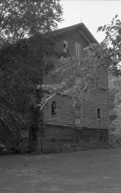
Photo: A J Butler (originally posted to Panoramio), CC BY 3.0 · Wikimedia Commons
Local history sources: richland.ohgenweb.org · en.wikipedia.org · richland.ohgenweb.org · richland.ohgenweb.org · historic-structures.com · en.wikipedia.org · commons.wikimedia.org · commons.wikimedia.org
Historic places
1 place in Worthington Township, Richland County on the National Register of Historic Places. Press a pin or a name for its whole record.
-
Rummell MillBuilding · Butler · listed 1982
- Address
- NE of Butler on SR 349.
- Where
- Butler, Richland County · ZIP 44822
- What it is
- Building
- Listed on the National Register
- 1982
- NRIS reference number
- 82003635
- Coordinates
- 40.59982, -82.40785
National Register file (NPS) ↗ Search Wikipedia ↗ Street map and directions ↗ On the Cracked Buckeye map
Source: National Park Service, National Register of Historic Places point file. The listing year is shown where NPS's certification date agrees with the listing's reference number. Listing recognizes significance; it does not restrict a private owner.
Water
Mostly private wells The water here
- Butler Village66% of residentsGroundwater wells (2 wells)
- Bellville Village18% of residentsGroundwater wells (2 wells)
- Perrysville Village14% of residentsGroundwater wells (2 wells)
- Clearfork MHP3% of residentsGroundwater wells (2 wells)
- Mohican Young Star Academy0% of residentsGroundwater wells (2 wells)
Hospitals, fire stations and more
Inside Worthington Township, Richland County's boundary: 1 poor-rated bridge, 2 museums and 3 spill cases. Press a pin or a name for its whole record and its source.
Bridges rated poor (1)
-
Freed Rd over Slater RunPoor · built 1920
- Condition
- Poor: a deck, superstructure, substructure or culvert rated 4 or below on the 0 to 9 scale
- What it is
- Bridge
- Built
- 1920
- Length
- 8 ft
- Owner
- County
- Vehicles a day
- 96
- Coordinates
- 40.57262, -82.40872
National Bridge Inventory (source) ↗ Street map and directions ↗
Source: FHWA National Bridge Inventory 2025. "Poor" means one major part rated 4 or below on the 0 to 9 scale; it calls for repair, not closing, unless the state posts or closes the bridge.
Museums, historical societies, gardens and zoos (2)
-
Butler Clear Fork Valley Historical SocietyHistorical society · Butler
- What it is
- Historical society
- City
- Butler
- Coordinates
- 40.56510, -82.40627
Search Wikipedia ↗ IMLS Museum Data Files (source) ↗ Street map and directions ↗
The museum list is IMLS's 2018 file; a museum may have closed or moved since.
-
Mohican Outdoor SchoolHistorical society · Butler
- What it is
- Historical society
- City
- Butler
- Coordinates
- 40.61585, -82.38385
Search Wikipedia ↗ IMLS Museum Data Files (source) ↗ Street map and directions ↗
The museum list is IMLS's 2018 file; a museum may have closed or moved since.
Source: IMLS Museum Data Files, 2018.
Spills reported since 2021 (3)
-
Fuel Diesel / Diesel Fuel (Vehicle On Or Off Road) Reached water2024-07-08 · Worthington Twp
- Reported
- 2024-07-08
- What spilled
- Fuel Diesel / Diesel Fuel (Vehicle On Or Off Road)
- Largest amount reported
- 100 gallons
- Reached a waterway
- 99 - Unnamed
- Where
- Worthington Twp, Richland County
- Ohio EPA district office
- NWDO
- Ohio EPA case number
- 2407EPA0001145
Ohio EPA spill reports (source) ↗ Street map and directions ↗
-
Oil Transformer Non Pcb2021-07-13 · Worthington Twp
- Reported
- 2021-07-13
- What spilled
- Oil Transformer Non Pcb
- Largest amount reported
- 10 gallons
- Where
- Worthington Twp, Richland County
- Ohio EPA district office
- NWDO
- Ohio EPA case number
- 2107EPA0001035
Ohio EPA spill reports (source) ↗ Street map and directions ↗
-
Natural Gas2026-08-11 · Worthington Twp
- Reported
- 2026-08-11
- What spilled
- Natural Gas
- Where
- Worthington Twp, Richland County
- Ohio EPA district office
- NWDO
- Ohio EPA case number
- 2608EPA0001476
Ohio EPA spill reports (source) ↗ Street map and directions ↗
Source: Ohio EPA emergency response spill reports, 2021 to September 2026, one point per case where Ohio EPA placed it. A report is what the caller or responder recorded; amounts are often blank or estimated.
Its ZIP codes
Each ZIP code that touches Worthington Township, Richland County, with the share of its residents who live here and the same headline figures as the ZIP page.
| ZIP | Share | Water | Radon | Home value | Schools | Flood |
|---|---|---|---|---|---|---|
| 44822 Worthington Township and Butler | 39% | Mostly private wells | 10.5 pCi/L average radon | Median year built 1976 | Clear Fork Valley Local · 4 stars overall | 4.0% of residents in the 1% floodplain |
| 44864 Green Township and Perrysville | 9% | Mostly private wells | 18.6 pCi/L average radon | Median year built 1972 | Loudonville-Perrysville Exempted Village · 4 stars overall | 5.0% of residents in the 1% floodplain |
| 44813 Jefferson Township and Bellville | 5% | Mostly private wells | 12.1 pCi/L average radon | Median year built 1973 | Clear Fork Valley Local · 4 stars overall | 3.2% of residents in the 1% floodplain |
Local government
Who holds office in Worthington Township, Richland County, how its elections and ballot issues came out, and the state auditor's record.
Money issues on the ballot since 2015: 1 of 1 passed.
Ballot issues
| Date | Issue | For | Against | Result |
|---|---|---|---|---|
| 2015-11-03 | Issue: Worthington Twp-Tax Levy-Renw'l- 2.5M 5Yrs-Fire (2.5 mills, renewal) | 680 | 255 | Passed (72.73% for) |
Elections for office
| Date | Office | Candidates and votes |
|---|---|---|
| 2015-11-03 | Trustee (number of seats not on file, so winners are not marked) | Keith D. Carr 383, 43.97%; Raymond Swank, Jr. 296, 33.98%; Timothy D. Titlow 192, 22.04% |
| 2015-11-03 | Trustee | Clint Sellers 617, 72.59%; Robert Sorquist 233, 27.41% |
| 2015-11-03 | Fiscal Officer | Shari K. Leech 701, 100.0% |
Winners in bold. Results from the county board of elections' official canvass unless marked.
Auditor of State record
- No fiscal caution, watch or emergency on the Auditor of State's lists.
- Financial Audit, 2023 to 2024, released 2026-03-10
The county
Richland County: 12 ZIP codes, 27 cities, villages and townships, 124,341 people.
Nearby places
Quick answers
What county is Worthington Township, Ohio in?
Worthington Township, Richland County is a township in Richland County, Ohio, with 2,047 residents.
When was Worthington Township, Ohio founded?
Worthington Township, Richland County was settled 1809; incorporated 1815. Founders on record: Erected from the west half of Green Township by act of the Ohio legislature; first settled by Samuel Lewis. Source
How did Worthington Township, Ohio get its name?
The township was named for Thomas Worthington, who was serving as governor of Ohio when it was organized in 1815. Source
What ZIP code is Worthington Township, Ohio?
Worthington Township, Richland County is served by ZIP codes 44822, 44864 and 44813; 44822 holds the largest share of its residents.
Where does Worthington Township, Ohio get its water?
The main water source for Worthington Township, Richland County (Butler Village): Mostly private wells.
Cite this page
Cite this page as:
Cracked Buckeye, "Worthington Township, Richland County", https://crackedbuckeye.com/place/worthington-township-richland-county/, built 2026-10-31, accessed [date].
How to cite · Report a correction · Built 2026-10-31
