Local events in Ward Township, Hocking County
Nothing is posted for Ward Township itself yet; here is what is on within 20 miles. All local events in Ward Township, Hocking County
Know a calendar we should watch? Send the link
Checked October 20; the events page is refreshed daily.
How Ward Township, Hocking County began
Ward Township, in the far eastern part of Hocking County, was organized in 1836 and named for landowner Naham (also recorded as Nathan) Ward; it is the only township of that name in Ohio. Its history is dominated by coal: Carbon Hill, established in 1873 as a Hocking County mining town and named directly for the coal beneath it, got a post office in 1879, and Murray City, platted in 1873 and incorporated in 1891 and named for landowner John Murray Brown, grew into one of the largest coal towns in the Hocking Valley, its population topping 2,000 at its early-20th-century peak. Both towns' fortunes rose and fell with the mines: labor unrest during the 1884-1885 Great Hocking Valley Strike touched the area, and after major mine closures in 1937 both settlements shrank sharply. Murray City, now the smallest municipality in Hocking County, and Carbon Hill and Sand Run, both unincorporated, are what remain of that industrial era in an otherwise rural, wooded township on the county's Athens and Perry County line.
Incorporated Organized as a township in 1836, by Named for landowner Naham (or Nathan) Ward.
Where the name comes from
Ward Township takes its name from a landowner identified in township records as Naham (or possibly Nathan) Ward. It is the only Ward Township in Ohio.
Before the town
No source reviewed documents a Native American village, mound, or treaty site specifically within Ward Township. Murray City sits along Snow Fork, which feeds Monday Creek, part of the same Hocking River drainage whose main stem carries the Delaware-derived name 'Hockhocking.' The wider Hocking Valley, including its eastern coal-bearing hills, was traveled and hunted by Delaware (Lenape), Wyandot, and Shawnee people in the 18th century, following the region's earlier Adena-culture presence, but no source ties a specific site to Ward Township's own ground.
Nations recorded here: Lenape (Delaware), Wyandot, Shawnee, Adena culture.
Timeline
- — Hocking County is organized (March 1) from parts of Athens, Fairfield, and Ross counties; Ward Township lies within it.
- — Ward Township is organized, named for landowner Naham (or Nathan) Ward.
- — Carbon Hill is established as a Hocking County coal-mining town, its name taken directly from the coal mined there; the same year, Murray City is platted, named for landowner John Murray Brown.
- — John Murray Brown builds a hotel at the site that becomes Murray City.
- — A post office opens in Carbon Hill.
- — The Great Hocking Valley coal strike unfolds across the region; Murray City, incorporated shortly afterward, counted Knights of Labor members and later United Mine Workers of America members among its residents.
- — Murray City is incorporated.
- — Murray City's population passes 2,000 at its peak, supporting hotels, saloons, churches, a rail depot, and dozens of businesses, drawing on the Greendale Coal Mine No. 07 and the Sunday Creek Coal Company's Mine No. 05 beneath the town.
- — A U.S. Forest Service aerial photograph records Murray City as a coal-mining town with a visible waste 'gob pile.'
- — Major mine closures around Murray City trigger a steep economic and population decline that continues for decades.
Stories
Two coal towns, one township
In the same year, 1873, two mining settlements took shape a few miles apart in what was already Ward Township: Carbon Hill, whose name plainly announced what was under it, and Murray City, platted by landowner John Murray Brown, who built a hotel there in 1875 to catch the trade the mines would bring. Murray City grew the faster of the two, drawing on the Greendale company's Mine No. 07 north of town and the Sunday Creek Coal Company's Mine No. 05, which ran directly under what became Murray City Park. By the early 1900s its population topped 2,000, and the town supported hotels, saloons, churches, and a busy rail depot, even fielding a semi-pro football team, the Murray City Tigers, in the 1920s. Both towns' workers lived through the region's hardest labor fights, including the Great Hocking Valley Strike of 1884-1885, and both organized, first as Knights of Labor and later as United Mine Workers of America locals.
The gob pile from the air
A U.S. Forest Service aerial photograph taken in October 1940, now held by the National Archives, looks down on Murray City and notes in its own caption the 'gob pile,' the mound of waste rock and low-grade coal left behind by decades of mining, sitting at the edge of town. The photo captures the town only a few years after the 1937 mine closures that ended Murray City's boom; what the camera shows is not a town at its peak but a coal town already living with what the mines had left behind, a landscape of shafts, spoil, and a town square built on ground riddled with old workings.
Photographs
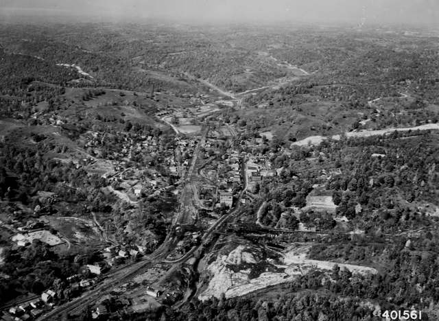
Photo: U.S. Forest Service / National Archives and Records Administration (NAID 2128905), public domain · Wikimedia Commons
Local history sources: en.wikipedia.org · en.wikipedia.org · en.wikipedia.org · commons.wikimedia.org · commons.wikimedia.org
Water
Six wells (4 MGD combined) in a sand-and-gravel aquifer in the Hocking River Buried Valley aquifer system, Dover Township, Athens County (2025 CCR). Ohio EPA's May 2012 source water assessment rates the source highly susceptible to contamination (thin clay cover, aquifer less than 20 ft deep). The water here
- Nelsonville58% of residentsGroundwater wells (3 wells)
- Carbon Hill Water Association33% of residentsHocking River Buried Valley Aquifer (wells)
- Murray City Village6% of residentsHocking River Buried Valley Aquifer (wells)
- New Straitsville, Village Of2% of residentsHocking River Buried Valley Aquifer (wells)
- Old Straitsville Water Association0% of residentsHocking River Buried Valley Aquifer (wells)
Hospitals, fire stations and more
Inside Ward Township, Hocking County's boundary: 1 fire or EMS station and 1 spill case. Press a pin or a name for its whole record and its source.
Fire and EMS stations (1)
-
Ward Township Volunteer Fire DepartmentCarbon Hill
- Address
- 15016 5th Street, Carbon Hill, OH 43111
- Coordinates
- 39.50134, -82.24025
USGS National Map structures (source) ↗ Street map and directions ↗
Source: USGS National Map structures (most Ohio records last updated 2019 to 2022), checked against the Columbus and Cleveland station lists. The department that answers a call is set by jurisdiction and mutual aid, not by distance.
Spills reported since 2021 (1)
-
Fuel Diesel / Diesel Fuel (Vehicle On Or Off Road)2023-02-10 · Ward Twp
- Reported
- 2023-02-10
- What spilled
- Fuel Diesel / Diesel Fuel (Vehicle On Or Off Road)
- Largest amount reported
- 15 gallons
- Where
- Ward Twp, Hocking County
- Ohio EPA district office
- SEDO
- Ohio EPA case number
- 2302EPA0000206
Ohio EPA spill reports (source) ↗ Street map and directions ↗
Source: Ohio EPA emergency response spill reports, 2021 to September 2026, one point per case where Ohio EPA placed it. A report is what the caller or responder recorded; amounts are often blank or estimated.
Its ZIP codes
Each ZIP code that touches Ward Township, Hocking County, with the share of its residents who live here and the same headline figures as the ZIP page.
The county
Athens County: 16 ZIP codes, 29 cities, villages and townships, 67,237 people.
Nearby places
Quick answers
What county is Ward Township, Ohio in?
Ward Township, Hocking County is a township in Athens County, Ohio, with 812 residents.
When was Ward Township, Ohio founded?
Ward Township, Hocking County was incorporated Organized as a township in 1836. Founders on record: Named for landowner Naham (or Nathan) Ward. Source
How did Ward Township, Ohio get its name?
Ward Township takes its name from a landowner identified in township records as Naham (or possibly Nathan) Ward. Source
What ZIP code is Ward Township, Ohio?
Ward Township, Hocking County is served by ZIP codes 43111, 43144 and 45764; 43111 holds the largest share of its residents.
Where does Ward Township, Ohio get its water?
The main water source for Ward Township, Hocking County (Nelsonville): Six wells (4 MGD combined) in a sand-and-gravel aquifer in the Hocking River Buried Valley aquifer system, Dover Township, Athens County (2025 CCR). Ohio EPA's May 2012 source water assessment rates the source highly susceptible to contamination (thin clay cover, aquifer less than 20 ft deep).
Cite this page
Cite this page as:
Cracked Buckeye, "Ward Township, Hocking County", https://crackedbuckeye.com/place/ward-township-hocking-county/, built 2026-10-31, accessed [date].
How to cite · Report a correction · Built 2026-10-31
