Local events in Vermilion
84 events in the next 90 days from 6 public calendars. All local events in Vermilion
Checked October 20; the events page is refreshed daily.
Deep dives about Vermilion
Long reads built from maps, newspapers and public records. All deep dives
How Vermilion began
Vermilion grew up at the mouth of the Vermilion River on Lake Erie, was incorporated as a village in 1837, and became known through the 19th century as a shipbuilding and commercial-fishing harbor -- a "village of lake captains" whose captains' houses still line its Harbor Town Historic District. The Bradley family, among its best-known shipbuilders, produced Captain Alva Bradley, a friend of the Edison family in nearby Milan whose Wikipedia entry credits him with giving young Thomas Edison his middle name. Vermilion's harbor proved too small for the era's largest lake freighters, so the city turned instead to tourism and residential development, merging with the lakefront village of Vermilion-on-the-Lake in 1960 and, since 1991, maintaining a working replica of its historic 1877 iron lighthouse -- built in part from melted-down Civil War cannons -- as a town landmark.
Settled early 19th century, incorporated 1837, by settlers at the mouth of the Vermilion River.
Where the name comes from
Named for the Vermilion River, on which the town sits at its mouth on Lake Erie.
Before the town
No source found records a Native American village, trail, mound or treaty event sited specifically at the town of Vermilion. The Vermilion River mouth lies within the Firelands, ceded by the Wyandot, Ottawa, Ojibwe, Potawatomi, Munsee and Lenape (Delaware) under the 1805 Treaty of Fort Industry. No county-specific mound, trail or village site within the present city limits was found in the sources checked.
Timeline
- — Vermilion was incorporated as a village.
- — Congress funded the first Vermilion lighthouse, a wooden structure built for $3,000.
- — The wooden lighthouse was rebuilt for $5,000 and fitted with a whale-oil lamp and a sixth-order Fresnel lens.
- — A permanent 34-foot octagonal iron lighthouse was completed, its iron recycled from smooth-bore Columbiad cannons made obsolete after the Civil War's Battle of Fort Sumter.
- — A postcard of the era advertised Vermilion, Ohio as "noted for its fisheries," reflecting the town's commercial Lake Erie fishing industry.
- — Construction began on the Vermilion Lagoons, among the first planned waterfront residential communities in the United States.
- — The 1877 iron lighthouse was removed as structurally unsound and replaced by an 18-foot steel tower; the old iron tower was later re-erected in 1935 as the East Charity Shoal Light on the St. Lawrence Seaway.
- — Vermilion merged with the neighboring lakefront village of Vermilion-on-the-Lake, becoming a city that straddles the Erie-Lorain county line.
- — A replica of the historic 1877 lighthouse, built by the Great Lakes Historical Society with $55,000 in public donations, was dedicated after being erected the previous October.
Stories
A lighthouse built from Civil War cannons
Vermilion's harbor light has had three lives. The first, a modest wooden tower funded by a $3,000 congressional grant in 1847, was rebuilt in 1859 with a whale-oil lamp and a Fresnel lens. In 1877 the government replaced it with something sturdier: a 34-foot octagonal iron lighthouse whose metal, tradition and the historical record agree, came from melted-down smooth-bore Columbiad cannons -- coastal artillery rendered obsolete once the Confederacy's guns fell silent at Fort Sumter. That iron tower stood watch over Vermilion's fishing fleet and lake schooners for half a century before it was judged structurally unsound and taken down in 1929, replaced by a plain 18-foot steel light; the old iron tower itself did not vanish, but was re-erected in 1935 far to the east as the East Charity Shoal Light on the St. Lawrence Seaway, where it still stands today. Vermilion went without its own historic silhouette for six decades, until local historian Theodore Wakefield led a fundraising campaign that let the Great Lakes Historical Society build a faithful replica, dedicated on June 6, 1992, restoring the town's signature landmark on the original site.
The shipbuilder who may have named Edison
Vermilion's Harbor Town Historic District preserves the homes of the lake captains and shipbuilders who once made the town a working port, among them Captain Alva Bradley, whose family shipyard built vessels for Great Lakes trade through much of the 19th century. According to the Bradley family's own Wikipedia entry, Alva Bradley was a close friend of Samuel Edison, whose family lived in nearby Milan, and the entry credits Bradley with giving the Edisons' young son the middle name "Alva" -- the name Thomas Alva Edison carried through a career that reshaped electric light, recorded sound and motion pictures. The claim is not corroborated on Edison's own Wikipedia page, which notes only that the boy was called "the young Alva" as a child without explaining the name's origin, so it is recorded here as a family tradition rather than a settled fact -- but it is a striking thread linking two Erie County towns eleven miles apart, one a shipbuilding harbor and the other the birthplace of one of America's most consequential inventors.
Photographs
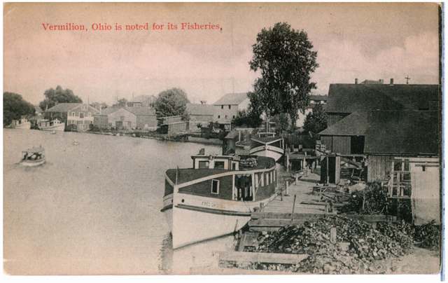
Photo: Columbus Metropolitan Library, via Digital Public Library of America / Ohio Digital Network, no known copyright restrictions · Wikimedia Commons
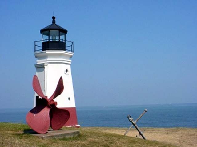
Photo: U.S. Department of Transportation, Federal Highway Administration, National Scenic Byways Program, via National Archives, public domain · Wikimedia Commons
Local history sources: en.wikipedia.org · en.wikipedia.org · en.wikipedia.org · en.wikipedia.org · commons.wikimedia.org · commons.wikimedia.org
Historic places
42 places in Vermilion on the National Register of Historic Places. Press a pin or a name for its whole record.
-
Barber ShopBuilding · Vermilion · listed 1979
- Address
- Liberty Ave., W. of Main St.
- Where
- Vermilion, Erie County · ZIP 44089
- What it is
- Building
- Listed on the National Register
- 1979
- NRIS reference number
- 79003932
- Coordinates
- 41.42199, -82.36541
National Register file (NPS) ↗ Search Wikipedia ↗ Street map and directions ↗ On the Cracked Buckeye map
-
Baxtine HouseBuilding · Vermilion · listed 1979
- Address
- Jct. of Ohio and Perry Sts.
- Where
- Vermilion, Erie County · ZIP 44089
- What it is
- Building
- Listed on the National Register
- 1979
- NRIS reference number
- 79003920
- Coordinates
- 41.41972, -82.36898
National Register file (NPS) ↗ Search Wikipedia ↗ Street map and directions ↗ On the Cracked Buckeye map
-
Bradley's, Capt., Second HouseBuilding · Vermilion · listed 1979
- Address
- 753 Decatur St.
- Where
- Vermilion, Erie County · ZIP 44089
- What it is
- Building
- Listed on the National Register
- 1979
- NRIS reference number
- 79003946
- Coordinates
- 41.42009, -82.36954
National Register file (NPS) ↗ Search Wikipedia ↗ Street map and directions ↗ On the Cracked Buckeye map
-
Bradley, Capt. Alva, HouseBuilding · Vermilion · listed 1979
- Address
- 5679 Huron St.
- Where
- Vermilion, Erie County · ZIP 44089
- What it is
- Building
- Listed on the National Register
- 1979
- NRIS reference number
- 79003938
- Coordinates
- 41.42344, -82.36727
National Register file (NPS) ↗ Search Wikipedia ↗ Street map and directions ↗ On the Cracked Buckeye map
-
Cargo WarehouseBuilding · Vermilion · listed 1979
- Address
- Liberty Ave., E. of Exchange St. and W. of Toledo St.
- Where
- Vermilion, Erie County · ZIP 44089
- What it is
- Building
- Listed on the National Register
- 1979
- NRIS reference number
- 79003941
- Coordinates
- 41.42113, -82.36279
National Register file (NPS) ↗ Search Wikipedia ↗ Street map and directions ↗ On the Cracked Buckeye map
-
Denzel, John, HouseBuilding · Vermilion · listed 1979
- Address
- 831 Douglas St.
- Where
- Vermilion, Erie County · ZIP 44089
- What it is
- Building
- Listed on the National Register
- 1979
- NRIS reference number
- 79003956
- Coordinates
- 41.41864, -82.36203
National Register file (NPS) ↗ Search Wikipedia ↗ Street map and directions ↗ On the Cracked Buckeye map
-
Englebry's Dry GoodsBuilding · Vermilion · listed 1979
- Address
- Main St., S. of Liberty Ave.
- Where
- Vermilion, Erie County · ZIP 44089
- What it is
- Building
- Listed on the National Register
- 1979
- NRIS reference number
- 79003951
- Coordinates
- 41.42137, -82.36511
National Register file (NPS) ↗ Search Wikipedia ↗ Street map and directions ↗ On the Cracked Buckeye map
-
Englebry's, Dr., OfficeBuilding · Vermilion · listed 1979
- Address
- Main St., S. of Liberty Ave.
- Where
- Vermilion, Erie County · ZIP 44089
- What it is
- Building
- Listed on the National Register
- 1979
- NRIS reference number
- 79003922
- Coordinates
- 41.42118, -82.36508
National Register file (NPS) ↗ Search Wikipedia ↗ Street map and directions ↗ On the Cracked Buckeye map
-
Erie County Bank BuildingBuilding · Vermilion · listed 1979
- Address
- Jct. of Liberty Ave. and Main St.
- Where
- Vermilion, Erie County · ZIP 44089
- What it is
- Building
- Listed on the National Register
- 1979
- NRIS reference number
- 79003953
- Coordinates
- 41.42171, -82.36520
National Register file (NPS) ↗ Search Wikipedia ↗ Street map and directions ↗ On the Cracked Buckeye map
-
Evangelical and Reformed ChurchBuilding · Vermilion · listed 1979
- Address
- Jct. of Grand and Ohio Sts.
- Where
- Vermilion, Erie County · ZIP 44089
- What it is
- Building
- Listed on the National Register
- 1979
- NRIS reference number
- 79003960
- Coordinates
- 41.42013, -82.36667
National Register file (NPS) ↗ Search Wikipedia ↗ Street map and directions ↗ On the Cracked Buckeye map
-
First Baptist ChurchBuilding · Vermilion · listed 1979
- Address
- 728 Main St.
- Where
- Vermilion, Erie County · ZIP 44089
- What it is
- Building
- Listed on the National Register
- 1979
- NRIS reference number
- 79003954
- Coordinates
- 41.42043, -82.36555
National Register file (NPS) ↗ Search Wikipedia ↗ Street map and directions ↗ On the Cracked Buckeye map
-
FRANCIS, JOSEPH, IRON SURF BOATStructure · Vermilion · listed 1979
- Address
- 480 Main St
- Where
- Vermilion, Erie County · ZIP 44089
- What it is
- Structure
- Listed on the National Register
- 1979
- NRIS reference number
- 79001829
- Coordinates
- 41.42480, -82.36700
National Register file (NPS) ↗ Search Wikipedia ↗ Street map and directions ↗ On the Cracked Buckeye map
-
Gilchrist, Capt., HouseBuilding · Vermilion · listed 1979
- Address
- 5644 Huron St.
- Where
- Vermilion, Erie County · ZIP 44089
- What it is
- Building
- Listed on the National Register
- 1979
- NRIS reference number
- 79003948
- Coordinates
- 41.42393, -82.36707
National Register file (NPS) ↗ Search Wikipedia ↗ Street map and directions ↗ On the Cracked Buckeye map
-
Gilchrist, Capt., Sr., HouseBuilding · Vermilion · listed 1979
- Address
- Jct. of Ohio and Grand Sts.
- Where
- Vermilion, Erie County · ZIP 44089
- What it is
- Building
- Listed on the National Register
- 1979
- NRIS reference number
- 79003921
- Coordinates
- 41.41980, -82.36600
National Register file (NPS) ↗ Search Wikipedia ↗ Street map and directions ↗ On the Cracked Buckeye map
-
Great Lakes Historical Society Marine MuseumBuilding · Vermilion · listed 1979
- Address
- Jct. of Main and Huron Sts.
- Where
- Vermilion, Erie County · ZIP 44089
- What it is
- Building
- Listed on the National Register
- 1979
- NRIS reference number
- 79003925
- Coordinates
- 41.42469, -82.36695
National Register file (NPS) ↗ Search Wikipedia ↗ Street map and directions ↗ On the Cracked Buckeye map
-
Hart's Drug StoreBuilding · Vermilion · listed 1979
- Address
- Jct. of Main St. and Liberty Ave.
- Where
- Vermilion, Erie County · ZIP 44089
- What it is
- Building
- Listed on the National Register
- 1979
- NRIS reference number
- 79003934
- Coordinates
- 41.42207, -82.36525
National Register file (NPS) ↗ Search Wikipedia ↗ Street map and directions ↗ On the Cracked Buckeye map
-
Horton, Capt. Charles, HouseBuilding · Vermilion · listed 1979
- Address
- 5564 Ferry St.
- Where
- Vermilion, Erie County · ZIP 44089
- What it is
- Building
- Listed on the National Register
- 1979
- NRIS reference number
- 79003926
- Coordinates
- 41.42302, -82.36687
National Register file (NPS) ↗ Search Wikipedia ↗ Street map and directions ↗ On the Cracked Buckeye map
-
House at 624 Washinton St.Building · Vermilion · listed 1979
- Address
- 624 Washington St.
- Where
- Vermilion, Erie County · ZIP 44089
- What it is
- Building
- Listed on the National Register
- 1979
- NRIS reference number
- 79003940
- Coordinates
- 41.42239, -82.36805
National Register file (NPS) ↗ Search Wikipedia ↗ Street map and directions ↗ On the Cracked Buckeye map
-
House on Huron Ave.Building · Vermilion · listed 1979
- Address
- Jct. of Huron and Washington Sts.
- Where
- Vermilion, Erie County · ZIP 44089
- What it is
- Building
- Listed on the National Register
- 1979
- NRIS reference number
- 79003942
- Coordinates
- 41.42319, -82.36814
National Register file (NPS) ↗ Search Wikipedia ↗ Street map and directions ↗ On the Cracked Buckeye map
-
Kishman Fish Company BuildingsBuilding · Vermilion · listed 1979
- Address
- Main St., S of Huron St. and N. of Liberty Ave.
- Where
- Vermilion, Erie County · ZIP 44089
- What it is
- Building
- Listed on the National Register
- 1979
- NRIS reference number
- 79003959
- Coordinates
- 41.42387, -82.36561
National Register file (NPS) ↗ Search Wikipedia ↗ Street map and directions ↗ On the Cracked Buckeye map
-
Masonic Temple BuildingBuilding · Vermilion · listed 1979
- Address
- Main St., S. of Liberty St.
- Where
- Vermilion, Erie County · ZIP 44089
- What it is
- Building
- Listed on the National Register
- 1979
- NRIS reference number
- 79003950
- Coordinates
- 41.42159, -82.36517
National Register file (NPS) ↗ Search Wikipedia ↗ Street map and directions ↗ On the Cracked Buckeye map
-
Meyers, Capt., HouseBuilding · Vermilion · listed 1979
- Address
- Jct of Ohio and Perry Sts.
- Where
- Vermilion, Erie County · ZIP 44089
- What it is
- Building
- Listed on the National Register
- 1979
- NRIS reference number
- 79003923
- Coordinates
- 41.42012, -82.36894
National Register file (NPS) ↗ Search Wikipedia ↗ Street map and directions ↗ On the Cracked Buckeye map
-
Minch, Capt., HouseBuilding · Vermilion · listed 1979
- Address
- 743 Grand St.
- Where
- Vermilion, Erie County · ZIP 44089
- What it is
- Building
- Listed on the National Register
- 1979
- NRIS reference number
- 79003943
- Coordinates
- 41.42012, -82.36602
National Register file (NPS) ↗ Search Wikipedia ↗ Street map and directions ↗ On the Cracked Buckeye map
-
Nickel, Old, Plate Railroad DepotBuilding · Vermilion · listed 1979
- Address
- Jct of Rte 60 and Norkfolk and Western Railroad
- Where
- Vermilion, Erie County · ZIP 44089
- What it is
- Building
- Listed on the National Register
- 1979
- NRIS reference number
- 79003958
- Coordinates
- 41.41563, -82.36550
National Register file (NPS) ↗ Search Wikipedia ↗ Street map and directions ↗ On the Cracked Buckeye map
-
Old Funeral PalorBuilding · Vermilion · listed 1979
- Address
- 5596 Liberty St.
- Where
- Vermilion, Erie County · ZIP 44089
- What it is
- Building
- Listed on the National Register
- 1979
- NRIS reference number
- 79003930
- Coordinates
- 41.42203, -82.36608
National Register file (NPS) ↗ Search Wikipedia ↗ Street map and directions ↗ On the Cracked Buckeye map
-
Old Harbour StoreBuilding · Vermilion · listed 1979
- Address
- Liberty Ave., W. of Main St.
- Where
- Vermilion, Erie County · ZIP 44089
- What it is
- Building
- Listed on the National Register
- 1979
- NRIS reference number
- 79003933
- Coordinates
- 41.42199, -82.36554
National Register file (NPS) ↗ Search Wikipedia ↗ Street map and directions ↗ On the Cracked Buckeye map
-
Old Interurban StationBuilding · Vermilion · listed 1979
- Address
- Jct. of Liberty Ave. and Exchange St.
- Where
- Vermilion, Erie County · ZIP 44089
- What it is
- Building
- Listed on the National Register
- 1979
- NRIS reference number
- 79003936
- Coordinates
- 41.42160, -82.36359
National Register file (NPS) ↗ Search Wikipedia ↗ Street map and directions ↗ On the Cracked Buckeye map
-
Old Jib's CornerBuilding · Vermilion · listed 1979
- Address
- Jct. of Liberty Ave. and Perry St.
- Where
- Vermilion, Erie County · ZIP 44089
- What it is
- Building
- Listed on the National Register
- 1979
- NRIS reference number
- 79003937
- Coordinates
- 41.42171, -82.36933
National Register file (NPS) ↗ Search Wikipedia ↗ Street map and directions ↗ On the Cracked Buckeye map
-
Old MillBuilding · Vermilion · listed 1979
- Address
- Jct. of Exchange and Mill Sts.
- Where
- Vermilion, Erie County · ZIP 44089
- What it is
- Building
- Listed on the National Register
- 1979
- NRIS reference number
- 79003929
- Coordinates
- 41.41643, -82.36337
National Register file (NPS) ↗ Search Wikipedia ↗ Street map and directions ↗ On the Cracked Buckeye map
-
Old Vermilion Banking Company BuildingBuilding · Vermilion · listed 1979
- Address
- 5581 Liberty Ave.
- Where
- Vermilion, Erie County · ZIP 44089
- What it is
- Building
- Listed on the National Register
- 1979
- NRIS reference number
- 79003935
- Coordinates
- 41.42170, -82.36567
National Register file (NPS) ↗ Search Wikipedia ↗ Street map and directions ↗ On the Cracked Buckeye map
-
Old Vermilion MillBuilding · Vermilion · listed 1979
- Address
- Douglas St.
- Where
- Vermilion, Erie County · ZIP 44089
- What it is
- Building
- Listed on the National Register
- 1979
- NRIS reference number
- 79003928
- Coordinates
- 41.41657, -82.36258
National Register file (NPS) ↗ Search Wikipedia ↗ Street map and directions ↗ On the Cracked Buckeye map
-
Pelton HouseBuilding · Vermilion · listed 1979
- Address
- 5345 South St.
- Where
- Vermilion, Erie County · ZIP 44089
- What it is
- Building
- Listed on the National Register
- 1979
- NRIS reference number
- 79003944
- Coordinates
- 41.41857, -82.36101
National Register file (NPS) ↗ Search Wikipedia ↗ Street map and directions ↗ On the Cracked Buckeye map
-
Pelton, Old, HotelBuilding · Vermilion · listed 1979
- Address
- 5780 Liberty Ave.
- Where
- Vermilion, Erie County · ZIP 44089
- What it is
- Building
- Listed on the National Register
- 1979
- NRIS reference number
- 79003952
- Coordinates
- 41.42207, -82.36960
National Register file (NPS) ↗ Search Wikipedia ↗ Street map and directions ↗ On the Cracked Buckeye map
-
Rae, Capt., HouseBuilding · Vermilion · listed 1979
- Address
- 690 Decatur St.
- Where
- Vermilion, Erie County · ZIP 44089
- What it is
- Building
- Listed on the National Register
- 1979
- NRIS reference number
- 79003939
- Coordinates
- 41.42116, -82.37005
National Register file (NPS) ↗ Search Wikipedia ↗ Street map and directions ↗ On the Cracked Buckeye map
-
Sail LoftBuilding · Vermilion · listed 1979
- Address
- Main St. S. of Ferry St.
- Where
- Vermilion, Erie County · ZIP 44089
- What it is
- Building
- Listed on the National Register
- 1979
- NRIS reference number
- 79003927
- Coordinates
- 41.42312, -82.36527
National Register file (NPS) ↗ Search Wikipedia ↗ Street map and directions ↗ On the Cracked Buckeye map
-
St. Mary Parish HallBuilding · Vermilion · listed 1979
- Address
- Exchnage St.
- Where
- Vermilion, Erie County · ZIP 44089
- What it is
- Building
- Listed on the National Register
- 1979
- NRIS reference number
- 79003931
- Coordinates
- 41.42073, -82.36352
National Register file (NPS) ↗ Search Wikipedia ↗ Street map and directions ↗ On the Cracked Buckeye map
-
Stagecoach InnBuilding · Vermilion · listed 1979
- Address
- 5798 Huron St.
- Where
- Vermilion, Erie County · ZIP 44089
- What it is
- Building
- Listed on the National Register
- 1979
- NRIS reference number
- 79003924
- Coordinates
- 41.42307, -82.36978
National Register file (NPS) ↗ Search Wikipedia ↗ Street map and directions ↗ On the Cracked Buckeye map
-
Steamboat HotelBuilding · Vermilion · listed 1979
- Address
- 532 Main St.
- Where
- Vermilion, Erie County · ZIP 44089
- What it is
- Building
- Listed on the National Register
- 1979
- NRIS reference number
- 79003947
- Coordinates
- 41.42373, -82.36634
National Register file (NPS) ↗ Search Wikipedia ↗ Street map and directions ↗ On the Cracked Buckeye map
-
Union, Old, School BuildingBuilding · Vermilion · listed 1979
- Address
- Jct. of South and Mill Sts.
- Where
- Vermilion, Erie County · ZIP 44089
- What it is
- Building
- Listed on the National Register
- 1979
- NRIS reference number
- 79003957
- Coordinates
- 41.41810, -82.36555
National Register file (NPS) ↗ Search Wikipedia ↗ Street map and directions ↗ On the Cracked Buckeye map
-
Vermilion Town HallBuilding · Vermilion · listed 1974
- Address
- 736 Main St.
- Where
- Vermilion, Erie County · ZIP 44089
- What it is
- Building
- Listed on the National Register
- 1974
- NRIS reference number
- 74001474
- Coordinates
- 41.42014, -82.36553
National Register file (NPS) ↗ Search Wikipedia ↗ Street map and directions ↗ On the Cracked Buckeye map
-
Walper, Capt. Henry, HouseBuilding · Vermilion · listed 1979
- Address
- 5475 South St.
- Where
- Vermilion, Erie County · ZIP 44089
- What it is
- Building
- Listed on the National Register
- 1979
- NRIS reference number
- 79003955
- Coordinates
- 41.41871, -82.36377
National Register file (NPS) ↗ Search Wikipedia ↗ Street map and directions ↗ On the Cracked Buckeye map
-
Young, Capt., HouseBuilding · Vermilion · listed 1979
- Address
- Jct. of Decatur & Ohio Sts.
- Where
- Vermilion, Erie County · ZIP 44089
- What it is
- Building
- Listed on the National Register
- 1979
- NRIS reference number
- 79003945
- Coordinates
- 41.41976, -82.37021
National Register file (NPS) ↗ Search Wikipedia ↗ Street map and directions ↗ On the Cracked Buckeye map
Source: National Park Service, National Register of Historic Places point file. The listing year is shown where NPS's certification date agrees with the listing's reference number. Listing recognizes significance; it does not restrict a private owner.
Water
Lake Erie (Vermilion River intake as secondary/backup) The water here
- Vermilion City90% of residentsLake Erie (Vermilion River intake as secondary/backup)
- Erie Co. Huron East District5% of residentsLake Erie
- Erie Co. Vermilion District5% of residentsLake Erie
Hospitals, fire stations and more
Inside Vermilion's boundary: 2 nursing homes, 2 fire and EMS stations, 4 public schools, 1 poor-rated bridge, 1 library, 6 museums, 1 police station and 18 spill cases. Press a pin or a name for its whole record and its source.
Nursing homes (2)
-
Kingston Health Center of Vermilion5 of 5 stars · Vermilion
- Address
- 4210 Telegraph Lane, Vermilion, OH 44089
- Certified beds
- 120
- Residents on an average day
- 100
- Medicare overall rating
- 5 of 5 stars
- Health inspections
- 4 of 5 stars
- Staffing
- 3 of 5 stars
- Quality measures
- 5 of 5 stars
- Penalties since 2023
- none
- Ownership
- For profit - Corporation
- Chain
- KINGSTON HEALTHCARE
- Takes
- Medicare and Medicaid
- Phone
- (440) 967-1800
- Medicare ID
- 365639
Medicare Care Compare ↗ CMS nursing home data (source) ↗ Street map and directions ↗
-
Mill Manor Care Center5 of 5 stars · Vermilion
- Address
- 983 Exchange St, Vermilion, OH 44089
- Certified beds
- 33
- Residents on an average day
- 30
- Medicare overall rating
- 5 of 5 stars
- Health inspections
- 4 of 5 stars
- Staffing
- 4 of 5 stars
- Quality measures
- 5 of 5 stars
- Penalties since 2023
- none
- Ownership
- For profit - Individual
- Takes
- Medicare and Medicaid
- Phone
- (440) 967-6614
- Medicare ID
- 366031
Medicare Care Compare ↗ CMS nursing home data (source) ↗ Street map and directions ↗
Source: CMS Care Compare nursing home provider and penalties files; Medicare star ratings run 1 to 5.
Fire and EMS stations (2)
-
Vermilion Fire Department Station 1Vermilion
- Address
- 5467 Ohio Street, Vermilion, OH 44089
- Coordinates
- 41.41990, -82.36374
USGS National Map structures (source) ↗ Street map and directions ↗
-
Vermilion Fire Department Station 2Vermilion
- Address
- 385 Overlook Road, Vermilion, OH 44089
- Coordinates
- 41.42689, -82.32045
USGS National Map structures (source) ↗ Street map and directions ↗
Source: USGS National Map structures (most Ohio records last updated 2019 to 2022), checked against the Columbus and Cleveland station lists. The department that answers a call is set by jurisdiction and mutual aid, not by distance.
Public schools (4)
-
Sailorway Middle School3.5 of 5 stars · Vermilion
- Address
- 5355 Sailorway Dr, Vermilion, OH 44089
- School district
- Vermilion Local School District
- Kind (NCES)
- Regular School
- Students, 2023-24
- 521
- Teachers (full-time equivalent)
- 27
- Report card, 2025-26
- 3.5 of 5 stars
- Performance index
- 79.6%
- Ohio building IRN
- 038331
- NCES school ID
- 390468204347
NCES school record ↗ Ohio School Report Card ↗ Street map and directions ↗
-
Vermilion Digital AcademyVermilion
- Address
- 1250 Sanford St, Vermilion, OH 44089
- Kind (NCES)
- Regular School
- Students, 2023-24
- 11
- Teachers (full-time equivalent)
- 1
- NCES school ID
- 390468206114
-
Vermilion Elementary School4 of 5 stars · Vermilion
- Address
- 1285 Douglas St, Vermilion, OH 44089
- School district
- Vermilion Local School District
- Kind (NCES)
- Regular School
- Students, 2023-24
- 516
- Teachers (full-time equivalent)
- 21
- Report card, 2025-26
- 4 of 5 stars
- Performance index
- 77.5%
- Ohio building IRN
- 035139
- NCES school ID
- 390468202667
NCES school record ↗ Ohio School Report Card ↗ Street map and directions ↗
-
Vermilion High School3 of 5 stars · Vermilion
- Address
- 1250 Sanford St, Vermilion, OH 44089
- School district
- Vermilion Local School District
- Kind (NCES)
- Regular School
- Students, 2023-24
- 617
- Teachers (full-time equivalent)
- 30
- Report card, 2025-26
- 3 of 5 stars
- Performance index
- 78.3%
- Four-year graduation rate
- 97.7%
- Ohio building IRN
- 038349
- NCES school ID
- 390468202669
NCES school record ↗ Ohio School Report Card ↗ Street map and directions ↗
Source: NCES EDGE public school locations 2024-25 and Common Core of Data 2023-24 (type, students, teachers); Ohio School Report Cards 2025-26 (Department of Education and Workforce), matched by name within the district.
Bridges rated poor (1)
-
Vermilion Road over Nsrr RailroadPoor · built 1975
- Condition
- Poor: a deck, superstructure, substructure or culvert rated 4 or below on the 0 to 9 scale
- What it is
- Bridge
- Built
- 1975
- Length
- 39 ft
- Owner
- City
- Vehicles a day
- 2,682
- Coordinates
- 41.42028, -82.35141
National Bridge Inventory (source) ↗ Street map and directions ↗
Source: FHWA National Bridge Inventory 2025. "Poor" means one major part rated 4 or below on the 0 to 9 scale; it calls for repair, not closing, unless the state posts or closes the bridge.
Public libraries (1)
-
Ritter Public LibraryCentral library · Vermilion
- Address
- 5680 Liberty Ave., Vermilion, OH 44089
- What it is
- Central library
- Library system
- Ritter Public Library
- Open
- 3,328 hours a year, 52 weeks
- Building
- 40,000 sq ft
- System's visits, FY2024
- 93,132
- System's loans, FY2024
- 217,507
- People the system serves
- 14,472
- Phone
- (440) 967-3798
IMLS Public Libraries Survey (source) ↗ Street map and directions ↗
Source: IMLS Public Libraries Survey FY2024 (outlets and their systems). Any Ohio resident can get a free card at any Ohio public library.
Museums, historical societies, gardens and zoos (6)
-
Brownhelm Historical AssociationHistorical society · Vermilion
- What it is
- Historical society
- City
- Vermilion
- Coordinates
- 41.40797, -82.35788
Search Wikipedia ↗ IMLS Museum Data Files (source) ↗ Street map and directions ↗
The museum list is IMLS's 2018 file; a museum may have closed or moved since.
-
Harbour TownHistorical society · Vermilion
- What it is
- Historical society
- City
- Vermilion
- Coordinates
- 41.42181, -82.36831
Search Wikipedia ↗ IMLS Museum Data Files (source) ↗ Street map and directions ↗
The museum list is IMLS's 2018 file; a museum may have closed or moved since.
-
Inland Seas Maritime MuseumMuseum · Vermilion
- What it is
- Museum
- City
- Vermilion
- Coordinates
- 41.40797, -82.35788
Search Wikipedia ↗ IMLS Museum Data Files (source) ↗ Street map and directions ↗
The museum list is IMLS's 2018 file; a museum may have closed or moved since.
-
Vermilion Area Archival SocietyHistorical society · Vermilion
- What it is
- Historical society
- City
- Vermilion
- Coordinates
- 41.41826, -82.36726
Search Wikipedia ↗ IMLS Museum Data Files (source) ↗ Street map and directions ↗
The museum list is IMLS's 2018 file; a museum may have closed or moved since.
-
Vermilion News Print Shop MuseumHistory museum · Vermilion
- What it is
- History museum
- City
- Vermilion
- Coordinates
- 41.42059, -82.36575
Search Wikipedia ↗ IMLS Museum Data Files (source) ↗ Street map and directions ↗
The museum list is IMLS's 2018 file; a museum may have closed or moved since.
-
Vermilion-On-The-LakeHistorical society · Vermilion
- What it is
- Historical society
- City
- Vermilion
- Coordinates
- 41.43005, -82.32390
Search Wikipedia ↗ IMLS Museum Data Files (source) ↗ Street map and directions ↗
The museum list is IMLS's 2018 file; a museum may have closed or moved since.
Source: IMLS Museum Data Files, 2018.
Police stations (1)
-
Vermilion Police DepartmentVermilion
- Address
- 5791 Liberty Avenue, Vermilion, OH 44089
- Coordinates
- 41.42181, -82.36929
USGS National Map structures (source) ↗ Street map and directions ↗
Source: USGS National Map structures, police stations, corrected and completed by hand (September 2026). The department that answers a call is set by jurisdiction, not by distance.
Spills reported since 2021 (18)
-
Fuel Diesel / Diesel Fuel (Vehicle On Or Off Road)2025-12-13 · Vermilion
- Reported
- 2025-12-13
- What spilled
- Fuel Diesel / Diesel Fuel (Vehicle On Or Off Road)
- Largest amount reported
- 20 gallons
- Where
- Vermilion, Lorain County
- Ohio EPA district office
- NEDO
- Ohio EPA case number
- 2512EPA0001995
Ohio EPA spill reports (source) ↗ Street map and directions ↗
-
Fuel Diesel / Diesel Fuel (Vehicle On Or Off Road)2025-11-17 · Vermilion
- Reported
- 2025-11-17
- What spilled
- Fuel Diesel / Diesel Fuel (Vehicle On Or Off Road)
- Largest amount reported
- 60 gallons
- Where
- Vermilion, Lorain County
- Ohio EPA district office
- NEDO
- Ohio EPA case number
- 2511EPA0001875
Ohio EPA spill reports (source) ↗ Street map and directions ↗
-
Coal Reached water2025-06-30 · Vermilion
- Reported
- 2025-06-30
- What spilled
- Coal
- Reached a waterway
- 22 - Vermilion River
- Where
- Vermilion, Erie County
- Ohio EPA district office
- NWDO
- Ohio EPA case number
- 2506EPA0001086
Ohio EPA spill reports (source) ↗ Street map and directions ↗
-
Oil Hydraulic Fluid(S) Reached water2024-08-27 · Vermilion
- Reported
- 2024-08-27
- What spilled
- Oil Hydraulic Fluid(S)
- Largest amount reported
- 3 gallons
- Reached a waterway
- 22 - Vermilion River
- Where
- Vermilion, Erie County
- Ohio EPA district office
- NWDO
- Ohio EPA case number
- 2408EPA0001474
Ohio EPA spill reports (source) ↗ Street map and directions ↗
-
Chemical(S) Unk2024-07-24 · Vermilion
- Reported
- 2024-07-24
- What spilled
- Chemical(S) Unk
- Where
- Vermilion, Lorain County
- Ohio EPA district office
- NEDO
- Ohio EPA case number
- 2407EPA0001266
Ohio EPA spill reports (source) ↗ Street map and directions ↗
-
Oil Motor / Lube Oil / Vehicle Reached water2024-06-03 · Vermilion
- Reported
- 2024-06-03
- What spilled
- Oil Motor / Lube Oil / Vehicle; Fuel Gasoline ( 25% Ethanol Not E85)
- Largest amount reported
- 5 gallons
- Reached a waterway
- 22 - Vermilion River
- Where
- Vermilion, Erie County
- Ohio EPA district office
- NEDO
- Ohio EPA case number
- 2406EPA0000925
Ohio EPA spill reports (source) ↗ Street map and directions ↗
-
Sludge (Non-Sewage)2024-02-24 · Vermilion
- Reported
- 2024-02-24
- What spilled
- Sludge (Non-Sewage)
- Where
- Vermilion, Erie County
- Ohio EPA district office
- NWDO
- Ohio EPA case number
- 2402EPA0000287
Ohio EPA spill reports (source) ↗ Street map and directions ↗
-
Oil Hydraulic Fluid(S)2023-11-22 · Vermilion
- Reported
- 2023-11-22
- What spilled
- Oil Hydraulic Fluid(S)
- Largest amount reported
- 48 gallons
- Where
- Vermilion, Lorain County
- Ohio EPA district office
- NEDO
- Ohio EPA case number
- 2311EPA0001971
Ohio EPA spill reports (source) ↗ Street map and directions ↗
-
Fuel Gasoline ( 25% Ethanol Not E85) Reached water2023-05-27 · Vermilion
- Reported
- 2023-05-27
- What spilled
- Fuel Gasoline ( 25% Ethanol Not E85)
- Largest amount reported
- 5 gallons
- Reached a waterway
- Vermilion River
- Where
- Vermilion, Erie County
- Ohio EPA district office
- NWDO
- Ohio EPA case number
- 2305EPA0000873
Ohio EPA spill reports (source) ↗ Street map and directions ↗
-
Ammonium Nitrate ((Nh4)(No3)) (H4N2O3)2023-05-14 · Vermilion
- Reported
- 2023-05-14
- What spilled
- Ammonium Nitrate ((Nh4)(No3)) (H4N2O3)
- Where
- Vermilion, Lorain County
- Ohio EPA district office
- NEDO
- Ohio EPA case number
- 2305EPA0000784
Ohio EPA spill reports (source) ↗ Street map and directions ↗
-
Sheen Rainbow / Hydrocarbon Reached water2022-08-14 · Vermilion
- Reported
- 2022-08-14
- What spilled
- Sheen Rainbow / Hydrocarbon
- Reached a waterway
- 22 - Lake Erie
- Where
- Vermilion, Erie County
- Ohio EPA district office
- NWDO
- Ohio EPA case number
- 2208EPA0001236
Ohio EPA spill reports (source) ↗ Street map and directions ↗
-
Sheen Rainbow / Hydrocarbon2022-07-10 · Vermilion
- Reported
- 2022-07-10
- What spilled
- Sheen Rainbow / Hydrocarbon
- Where
- Vermilion, Erie County
- Ohio EPA district office
- NWDO
- Ohio EPA case number
- 2207EPA0001047
Ohio EPA spill reports (source) ↗ Street map and directions ↗
-
Oil Hydraulic Fluid(S) Reached water2021-12-05 · Vermilion
- Reported
- 2021-12-05
- What spilled
- Oil Hydraulic Fluid(S)
- Reached a waterway
- 22 - Vermilion River
- Where
- Vermilion, Erie County
- Ohio EPA district office
- NWDO
- Ohio EPA case number
- 2112EPA0001815
Ohio EPA spill reports (source) ↗ Street map and directions ↗
-
Fuel Gasoline ( 25% Ethanol Not E85)2021-11-07 · Vermilion
- Reported
- 2021-11-07
- What spilled
- Fuel Gasoline ( 25% Ethanol Not E85)
- Where
- Vermilion, Lorain County
- Ohio EPA district office
- NEDO
- Ohio EPA case number
- 2111EPA0001710
Ohio EPA spill reports (source) ↗ Street map and directions ↗
-
Fuel Diesel / Diesel Fuel (Vehicle On Or Off Road) Reached water2021-06-16 · Vermilion
- Reported
- 2021-06-16
- What spilled
- Fuel Diesel / Diesel Fuel (Vehicle On Or Off Road)
- Largest amount reported
- 50 gallons
- Reached a waterway
- 22 - Vermilion River
- Where
- Vermilion, Erie County
- Ohio EPA district office
- NWDO
- Ohio EPA case number
- 2106EPA0000874
Ohio EPA spill reports (source) ↗ Street map and directions ↗
-
Fuel Diesel / Diesel Fuel (Vehicle On Or Off Road)2021-05-27 · Vermilion
- Reported
- 2021-05-27
- What spilled
- Fuel Diesel / Diesel Fuel (Vehicle On Or Off Road)
- Largest amount reported
- 100 gallons
- Where
- Vermilion, Erie County
- Ohio EPA district office
- NWDO
- Ohio EPA case number
- 2105EPA0000745
Ohio EPA spill reports (source) ↗ Street map and directions ↗
-
Fuel Gasoline ( 25% Ethanol Not E85) Reached water2026-08-13 · Vermilion
- Reported
- 2026-08-13
- What spilled
- Fuel Gasoline ( 25% Ethanol Not E85)
- Largest amount reported
- 10 gallons
- Reached a waterway
- 47 - Vermilion River
- Where
- Vermilion, Lorain County
- Ohio EPA district office
- NEDO
- Ohio EPA case number
- 2608EPA0001492
Ohio EPA spill reports (source) ↗ Street map and directions ↗
-
Fuel Diesel / Diesel Fuel (Vehicle On Or Off Road)2026-06-17 · Vermilion
- Reported
- 2026-06-17
- What spilled
- Fuel Diesel / Diesel Fuel (Vehicle On Or Off Road)
- Largest amount reported
- 1 gallons
- Where
- Vermilion, Erie County
- Ohio EPA district office
- NWDO
- Ohio EPA case number
- 2606EPA0001085
Ohio EPA spill reports (source) ↗ Street map and directions ↗
Source: Ohio EPA emergency response spill reports, 2021 to September 2026, one point per case where Ohio EPA placed it. A report is what the caller or responder recorded; amounts are often blank or estimated.
Its ZIP codes
Each ZIP code that touches Vermilion, with the share of its residents who live here and the same headline figures as the ZIP page.
| ZIP | Share | Water | Radon | Home value | Schools | Flood |
|---|---|---|---|---|---|---|
| 44089 Vermilion | 66% | Lake Erie (Vermilion River intake as secondary/backup) | 7.6 pCi/L average radon | Median year built 1969 | Vermilion Local · 3.5 stars overall | 3.1% of residents in the 1% floodplain |
Local government
Who holds office in Vermilion, how its elections and ballot issues came out, and the state auditor's record.
Money issues on the ballot since 2017: 1 of 1 passed; of those asking for new or higher taxes, 1 of 1.
Ballot issues
| Date | Issue | For | Against | Result |
|---|---|---|---|---|
| 2021-11-02 | 3: 3 Proposed Charter Amendment - Vermilion City, Erie and Lorain Counties (Article III, | 745 | 395 | Passed (65.35% for) |
| 2021-11-02 | 4: 4 Proposed Charter Amendment - Vermilion City, Erie and Lorain Counties (Article IV) | 697 | 417 | Passed (62.57% for) |
| 2021-11-02 | 5: 5 Proposed Ordinance (By Initiative Petition) - Vermilion City, Erie and Lorain Counties | 714 | 415 | Passed (63.24% for) |
| 2021-11-02 | 6: 6 Proposed Charter Amendment - Vermilion City, Erie and Lorain Counties (Article III, | 741 | 364 | Passed (67.06% for) |
| 2021-11-02 | 7: 7 Proposed Charter Amendment - Vermilion City, Erie and Lorain Counties (Article IV) | 718 | 356 | Passed (66.85% for) |
| 2021-11-02 | 8: 8 Proposed Charter Amendment - Vermilion City, Erie and Lorain Counties (Article XI, | 734 | 361 | Passed (67.03% for) |
| 2017-11-07 | 5: #5 Vermilion City Tax Levy Additional Parks&Recreation | 832 | 490 | Passed (62.93% for) |
Elections for office
| Date | Office | Candidates and votes |
|---|---|---|
| 2025-11-04 | President of Council | Jeff Lucas 1,115, 100.0% |
| 2025-11-04 | Member of Council, Ward 5 | Alec Bonawit 391, 100.0% |
| 2025-11-04 | Member of Council, Ward 4 | Homer S. Taft 274, 55.47%; Philip Gerald Dombrowski 220, 44.53% |
| 2025-11-04 | Member of Council, Ward 3 | Drew R. Werley 57, 100.0% |
| 2025-11-04 | Member of Council at Large | Gary B. Howell Jr. 1,056, 100.0% |
| 2025-11-04 | Mayor | Russell Owens 1,118, 100.0% |
| 2021-11-02 | President of Council | Larry Drouhard 432, 39.34%; Monica Stark 666, 60.66% |
| 2021-11-02 | Member of Council at Large | Steve Herron 764, 72.49%; Homer S. Taft 290, 27.51% |
| 2021-05-04 | Mayor | Jim Forthofer 562, 67.87%; Jerry Kyle 155, 18.72%; Daniel G. Roth 111, 13.41% |
| 2019-11-05 | President of Council | Steve Herron 368, 100.0% |
Winners in bold. Results from the county board of elections' official canvass unless marked.
Auditor of State record
- No fiscal caution, watch or emergency on the Auditor of State's lists.
- Financial Health Indicators (the Auditor of State's 17 measures; critical / cautionary / positive): 2020 1 / 2 / 14; 2021 1 / 0 / 16; 2022 0 / 3 / 14; 2023 0 / 2 / 15; 2024 0 / 2 / 15; 2025 0 / 3 / 13.
- Financial Audit, 2024, released 2026-02-24
- Financial Audit, 2023, released 2024-07-25
The county
Erie County: 7 ZIP codes, 15 cities, villages and townships, 78,997 people.
Nearby places
Rain and snow
How much has actually fallen on Vermilion, day by day, from 1893 to now. Daily totals, not averages.
- rain, last 30 days
- 1.94 in
- 2026-09-30 to 2026-10-29
- rain so far in 2026
- 36.7 in
- 3.3 in above normal for the date
- snow so far in 2026
- 27.4 in
- a normal year brings 43.7 in
- a normal year
- 39.3 in
- average of 30 years, 1991-2020
| Month | Rain (in) | Snow (in) | Days counted |
|---|---|---|---|
| October 2026 | 1.94 | — | 29 |
| September 2026 | 2.24 | — | 30 |
| August 2026 | 7.49 | — | 31 |
| July 2026 | 6.27 | — | 31 |
| June 2026 | 3.27 | — | 30 |
| May 2026 | 4.52 | — | 31 |
| April 2026 | 6.21 | — | 30 |
| March 2026 | 2.83 | 0.2 | 31 |
| February 2026 | 0.41 | 3.7 | 28 |
| January 2026 | 1.51 | 23.6 | 31 |
| December 2025 | 2.12 | 8.7 | 31 |
| November 2025 | 1.38 | 1.1 | 30 |
| Wettest year | 2011 — 58.3 in |
|---|---|
| Driest year | 1963 — 18.1 in |
| Snowiest year | 1910 — 77.8 in |
| Wettest day on record | 5 July 1969 — 4.60 in |
| Heaviest snowfall in a day | 1 March 1954 — 15.22 in |
| Deepest snow on the ground | 27 March 1896 — 19.02 in |
Mostly estimated. Only 6% of these days come from a gauge standing inside Vermilion - the rest are worked out from the nearest gauges around it, so read them as close estimates rather than readings.
48,412 days of records, 1893-04-01 to 2026-10-29. Source: NOAA NCEI GHCN-Daily, 3,240 gauges in and around Ohio. A day is "gauged" when a gauge standing inside the boundary reported it, and the value is the mean of those gauges. Otherwise it is interpolated by inverse distance from every gauge reporting within 50 miles. Nothing is carried forward, back-filled or smoothed. Against NOAA nClimDiv county monthly precipitation over 136,848 complete county-months (checked 2026-10-31): correlation 0.9515, median absolute difference 0.217 in a month. Built 2026-10-31 from the Cracked Buckeye precipitation archive. Snow is the softer number — snowfall is measured by hand with a ruler, no agency publishes a gridded county snowfall series, and blowing snow defeats every observer.
Environmental permits and filings
What Ohio EPA has on file for Vermilion: permits, inspections, violations, cleanups and the state loans behind sewer and water work. Every line links to the agency's own document.
- facilities and sites on file
- 33
- those placed on the map inside Vermilion
| Program | Facilities and sites |
|---|---|
| Wastewater and stormwater discharge | 14 |
| Wetland and stream fill | 5 |
| Air pollution | 3 |
| Sewer and water-line construction | 3 |
| State sewer loans | 3 |
| Brownfield | 2 |
| Hazardous waste | 2 |
| Public drinking water | 1 |
| Date | Facility or site | What |
|---|---|---|
| VERMILION CITY PWS | Public drinking water compliance letter | |
| LIBERTY AVENUE PROPERTY | Wetland and stream fill violation resolved | |
| VERMILION CITY PWS | Public drinking water compliance letter | |
| VERMILION CITY PWS | Public drinking water compliance letter | |
| DA PETROLEUM LLC (BULL RUN) | Wastewater and stormwater discharge permit | |
| VERMILION CITY PWS | Public drinking water compliance letter | |
| FGV DEV LLC | Wetland and stream fill permit | |
| VERMILION CITY PWS | Public drinking water notice of violation | |
| VERMILION CITY PWS | Public drinking water notice of violation | |
| JACKSON STREET IMPROVEMENTS | Wastewater and stormwater discharge permit | |
| HIGHBRIDGE PHASE 3 | Wastewater and stormwater discharge permit | |
| HALEY STREET RECONSTRUCTION | Wastewater and stormwater discharge permit | |
| VERMILLION BUSINESS PARK | Sewer and water-line construction permit | |
| VERMILLION BUSINESS PARK | Sewer and water-line construction permit | |
| VERMILLION BUSINESS PARK | Wastewater and stormwater discharge permit | |
| VERMILION CITY PWS | Public drinking water plan | |
| TRADESMAN PARK | Wastewater and stormwater discharge permit | |
| VERMILION CITY PWS | Public drinking water inspection | |
| VERMILION CITY PWS | Public drinking water inspection | |
| CLEVELAND STONE COMPANIES LLC | Air pollution report | |
| VERMILION CITY PWS | Public drinking water inspection | |
| VERMILLION BUSINESS PARK | Sewer and water-line construction permit | |
| APEX STRENGTH CLUB | Wastewater and stormwater discharge permit | |
| VERMILION CITY PWS | Public drinking water plan | |
| VERMILION CITY PWS | Public drinking water plan |
Source: Ohio EPA eDocument portal (edocpub.epa.ohio.gov), indexed 2026-10-14. Facilities are placed on the map from Ohio EPA's own map layers, EPA's Facility Registry, coordinates written in the filings, or a geocoded street address. A permit filed under a private person's name (most are household septic systems) is counted but never named, placed or linked; licenses for individual workers and open-burning notices are left out entirely.
Quick answers
What county is Vermilion, Ohio in?
Vermilion is a city in Erie County, Ohio, with 10,524 residents.
When was Vermilion, Ohio founded?
Vermilion was settled early 19th century; incorporated 1837. Founders on record: settlers at the mouth of the Vermilion River. Source
How did Vermilion, Ohio get its name?
Named for the Vermilion River, on which the town sits at its mouth on Lake Erie. Source
What ZIP code is Vermilion, Ohio?
Most of Vermilion is in ZIP code 44089.
Where does Vermilion, Ohio get its water?
The main water source for Vermilion (Vermilion City): Lake Erie (Vermilion River intake as secondary/backup).
Cite this page
Cite this page as:
Cracked Buckeye, "Vermilion, Erie County", https://crackedbuckeye.com/place/vermilion/, built 2026-10-31, accessed [date].
How to cite · Report a correction · Built 2026-10-31
