Local events in Stoutsville
Stoutsville itself has 1 event posted in the next 90 days; the others here are within 10 miles. All local events in Stoutsville
Checked October 20; the events page is refreshed daily.
How Stoutsville began
Stoutsville was laid out in 1854 by Benjamin Stout, whose father George Stout had settled a mile to the north fifty years earlier, on the line of the railroad that became the Cincinnati and Muskingum Valley. The village grew quickly once the line was running, its population more than doubling between 1870 and 1880, and by the early twentieth century supported two grain elevators, a bank, and its own newspaper, the Fairfield-Pickaway News. Two GNIS-listed historical names sit inside its ZIP code: "Wyandotte," a neighboring stop on the same rail line, and "Millers," which no source consulted could confirm or explain. Stoutsville today is a small Clear Creek Township village whose children have attended school in nearby Amanda since 2003.
Settled 1797 (Jacob Shumaker, credited as Clear Creek Township's first settler) or 1804 (George Stout, father of the village's founder, settles about a mile north of the future village site), platted 1854, by Benjamin Stout, by Benjamin Stout.
Where the name comes from
Stoutsville is named for its founder, Benjamin Stout, an early settler's son who laid out the village on his own land in 1854. Graham's 1883 and Miller's 1912 county histories, Scott's 1877 history, and Wikipedia all agree on this simple derivation without variation.
Before the town
No source consulted records a Native village, camp, treaty line, or documented encounter at Stoutsville itself or elsewhere in Clear Creek Township. The nearest documented prehistoric site is Cross Mound (also called the Tarlton Cross Mound), a Greek-cross-shaped earthwork about ninety feet along each arm, standing in Fairfield County near Tarlton and reached historically from Stoutsville by the old Amanda and Tarlton pike that ran through the township; Wikipedia reports ongoing scholarly disagreement over who built it, with an Ohio archaeologist favoring a Middle Woodland (Hopewell) date and other researchers proposing construction after AD 1000 by Fort Ancient-culture people. The GNIS historical name "Wyandotte," attached to Stoutsville's ZIP code, was in fact the name of a station on the same Cincinnati and Muskingum Valley Railroad line as Stoutsville, per Miller's 1912 county history; no source found ties the station name to any documented Wyandot village or encounter at that spot, so it may be no more than a commemorative railroad-era name.
- Cross Mound (Tarlton Cross Mound) (earthwork) — Cross Mound Park, Fairfield County, near Tarlton, reached historically from Stoutsville by the Amanda and Tarlton pike, disputed -- possibly Middle Woodland (Hopewell), or built after AD 1000 by Fort Ancient-culture people (en.wikipedia.org)
Timeline
- — Jacob Shumaker settles in what becomes Clear Creek Township, the township's first recorded settler.
- — George Stout, from Bucks County, Pennsylvania, settles about a mile north of the future village site.
- — John Leist settles in Clear Creek Township; he goes on to serve in the Ohio Legislature for eight years and as a canal-damage commissioner for twenty-two.
- — Benjamin Stout lays out the village of Stoutsville on the line of the railroad that becomes the Cincinnati and Muskingum Valley Railroad.
- — Stoutsville's post office opens.
- — The village's population grows from 160 to 340, a 112.5 percent increase over the decade.
- — The cornerstone is laid for the union church shared by Stoutsville's Lutheran and German Reformed congregations.
- — H. O. Hardin founds the Fairfield-Pickaway News at Stoutsville, an eight-page, non-political paper that by 1912 has never changed ownership.
- — Stoutsville's local elementary and junior high schools close, and students begin attending the Amanda-Clearcreek Local School District in nearby Amanda.
Stories
A Village Built on the Railroad
When Benjamin Stout laid out his namesake village in 1854, he set it directly on the line of the railroad that would become the Cincinnati and Muskingum Valley -- a line chartered in 1851 to connect Cincinnati, by way of Zanesville, to the eastern seaboard. The gamble paid off quickly: by the early 1880s Stoutsville had two steam mills with grain elevators, one of them said to be among the finest on the whole line, two dry-goods stores, a drugstore, and its own four-room school. The village's population more than doubled in the 1870s alone, from 160 to 340 people, as farm families from across Clear Creek Township shipped their grain out through the depot Stout's railroad-side plat had made possible.
A Newspaper That Never Changed Hands
H. O. Hardin founded the Fairfield-Pickaway News at Stoutsville on August 25, 1888, an eight-page paper serving the farm country straddling the two counties' line. By the time Fairfield County's 1912 history was written, the paper had never once changed ownership, operated out of a building of its own, and carried a circulation of 600 subscribers who paid in advance -- a small but stable institution the county history singled out as non-political but independent in its opinions.
Photographs
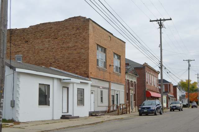
Photo: Nyttend, via Wikimedia Commons, public domain · Wikimedia Commons
Local history sources: archive.org · archive.org · archive.org · en.wikipedia.org · en.wikipedia.org · en.wikipedia.org · commons.wikimedia.org
Water
No water-system data is linked to Stoutsville's ZIP codes yet.
Hospitals, fire stations and more
Inside Stoutsville's boundary: 1 fire or EMS station and 1 spill case. Press a pin or a name for its whole record and its source.
Fire and EMS stations (1)
-
Clearcreek Township Fire Department Station 510Stoutsville
- Address
- 11042 Main Street, Stoutsville, OH 43154
- Coordinates
- 39.60501, -82.82365
USGS National Map structures (source) ↗ Street map and directions ↗
Source: USGS National Map structures (most Ohio records last updated 2019 to 2022), checked against the Columbus and Cleveland station lists. The department that answers a call is set by jurisdiction and mutual aid, not by distance.
Spills reported since 2021 (1)
-
Material Unknown2025-07-26 · Stoutsville
- Reported
- 2025-07-26
- What spilled
- Material Unknown
- Where
- Stoutsville, Fairfield County
- Ohio EPA district office
- CDO
- Ohio EPA case number
- 2507EPA0001252
Ohio EPA spill reports (source) ↗ Street map and directions ↗
Source: Ohio EPA emergency response spill reports, 2021 to September 2026, one point per case where Ohio EPA placed it. A report is what the caller or responder recorded; amounts are often blank or estimated.
Its ZIP codes
Each ZIP code that touches Stoutsville, with the share of its residents who live here and the same headline figures as the ZIP page.
| ZIP | Share | Water | Radon | Home value | Schools | Flood |
|---|---|---|---|---|---|---|
| 43154 Clearcreek Township and Stoutsville | 19% | Mostly private wells | 6.7 pCi/L average radon | Median year built 1984 | Amanda-Clearcreek Local · 3 stars overall | 0.0% of residents in the 1% floodplain |
Local government
Who holds office in Stoutsville, how its elections and ballot issues came out, and the state auditor's record.
Auditor of State record
- No fiscal caution, watch or emergency on the Auditor of State's lists.
- Basic Audit, 2023 to 2024, released 2025-09-02
The county
Fairfield County: 13 ZIP codes, 27 cities, villages and townships, 144,692 people.
Nearby places
Rain and snow
How much has actually fallen on Stoutsville, day by day, from 1893 to now. Daily totals, not averages.
- rain, last 30 days
- 1.10 in
- 2026-09-30 to 2026-10-29
- rain so far in 2026
- 48.7 in
- 13.4 in above normal for the date
- snow so far in 2026
- 13.8 in
- a normal year brings 15.6 in
- a normal year
- 41.5 in
- average of 30 years, 1991-2020
| Month | Rain (in) | Snow (in) | Days counted |
|---|---|---|---|
| October 2026 | 1.10 | — | 29 |
| September 2026 | 8.67 | — | 30 |
| August 2026 | 9.15 | — | 31 |
| July 2026 | 7.71 | — | 31 |
| June 2026 | 2.90 | — | 30 |
| May 2026 | 5.74 | — | 31 |
| April 2026 | 3.29 | — | 30 |
| March 2026 | 7.30 | 0.5 | 31 |
| February 2026 | 1.28 | 3.5 | 28 |
| January 2026 | 1.55 | 9.7 | 31 |
| December 2025 | 2.02 | 8.6 | 31 |
| November 2025 | 2.88 | 1.1 | 30 |
| Wettest year | 2011 — 58.0 in |
|---|---|
| Driest year | 1930 — 24.3 in |
| Snowiest year | 1910 — 45.5 in |
| Wettest day on record | 4 July 1935 — 4.11 in |
| Heaviest snowfall in a day | 17 February 1910 — 11.60 in |
| Deepest snow on the ground | 29 November 1950 — 22.94 in |
Estimated, not measured. No rain gauge has ever stood inside Stoutsville, so every figure here is worked out from the gauges around it - the nearest ones weighted most. Treat them as close estimates rather than readings.
48,313 days of records, 1893-01-01 to 2026-10-29. Source: NOAA NCEI GHCN-Daily, 3,240 gauges in and around Ohio. A day is "gauged" when a gauge standing inside the boundary reported it, and the value is the mean of those gauges. Otherwise it is interpolated by inverse distance from every gauge reporting within 50 miles. Nothing is carried forward, back-filled or smoothed. Against NOAA nClimDiv county monthly precipitation over 136,848 complete county-months (checked 2026-10-31): correlation 0.9515, median absolute difference 0.217 in a month. Built 2026-10-31 from the Cracked Buckeye precipitation archive. Snow is the softer number — snowfall is measured by hand with a ruler, no agency publishes a gridded county snowfall series, and blowing snow defeats every observer.
Quick answers
What county is Stoutsville, Ohio in?
Stoutsville is a village in Fairfield County, Ohio, with 579 residents.
When was Stoutsville, Ohio founded?
Stoutsville was settled 1797 (Jacob Shumaker, credited as Clear Creek Township's first settler) or 1804 (George Stout, father of the village's founder, settles about a mile north of the future village site); laid out 1854, by Benjamin Stout. Founders on record: Benjamin Stout. Source
How did Stoutsville, Ohio get its name?
Stoutsville is named for its founder, Benjamin Stout, an early settler's son who laid out the village on his own land in 1854. Source
What ZIP code is Stoutsville, Ohio?
Most of Stoutsville is in ZIP code 43154.
Where does Stoutsville, Ohio get its water?
The main water source for Stoutsville: Mostly private wells.
Cite this page
Cite this page as:
Cracked Buckeye, "Stoutsville, Fairfield County", https://crackedbuckeye.com/place/stoutsville/, built 2026-10-31, accessed [date].
How to cite · Report a correction · Built 2026-10-31
