Local events in Sinking Spring
Nothing is posted for Sinking Spring itself yet; here is what is on within 20 miles. All local events in Sinking Spring
Know a calendar we should watch? Send the link
Checked October 20; the events page is refreshed daily.
How Sinking Spring began
Sinking Spring was the site of the first settlement within the limits of Highland County, made by John Wilcoxson in 1796; Jacob Hiestand platted the town itself in 1815, naming it for a losing stream — one that sinks underground — near the original town site. A post office has operated there since 1817, and the village's octagonal schoolhouse, built in 1831 and still standing on the town square, is the only building of its kind in Ohio. U.S. District Judge Charles Willing Byrd, grandson of the founder of Richmond, Virginia, retired to Sinking Spring for its water and died there in 1828. The village, in southeastern Brushcreek Township near Fort Hill, remains a small crossroads community of just over 100 residents.
Settled 1796, platted 1815, by Jacob Hiestand (1815 plat); John Wilcoxson was the first settler.
Where the name comes from
The village was named for a losing stream — one that disappears underground — near the original town site.
Before the town
No named Native villages, trails or burial sites are recorded within the village of Sinking Spring itself in the sources checked. The Hopewell-built Fort Hill earthworks (100 BC to AD 500) lie a few miles away in the same Brushcreek Township, on the Brush Creek valley, but Fort Hill is a separate site in unincorporated township land, not inside the village's corporate limits, and is not attributed to the village here. The land was within the roughly two-thirds of Ohio ceded by the Treaty of Greenville (1795), signed by the Wyandot, Shawnee, Lenape (Delaware), Miami, Ottawa and other nations.
Nations recorded here: Shawnee, Wyandot, Lenape (Delaware), Hopewell culture.
Timeline
- — John Wilcoxson settles at Sinking Spring, the first settlement within the present limits of Highland County.
- — Jacob Hiestand plats the town of Sinking Spring.
- — A post office called Sinking Spring begins operating in the village.
- — August 25: U.S. District Judge Charles Willing Byrd dies at Sinking Spring, where he had settled for the believed medicinal properties of its water, and is buried in the village's old rural cemetery.
- — The village's population is recorded as 109.
- — An octagonal one-room schoolhouse is built on the village's town square; it is later used as a Civil War militia headquarters and arms store, and remains the only building of its kind in Ohio.
- — The Sinking Spring Methodist Church is built; it is the oldest church in Highland County still in use as a church.
- — The village records 238 residents.
Stories
A federal judge retires for the water
Charles Willing Byrd was a grandson of William Byrd II, the founder of Richmond, Virginia, and had served as secretary and then acting governor of the Northwest Territory before President Thomas Jefferson named him a U.S. District Judge for Ohio in 1803, a post he held for the rest of his life. Byrd was famously careful about health: he kept a small silver scale on his family's dining table to weigh out food portions. Late in life he came to believe that the waters at Sinking Spring, in what was by then Highland County, possessed medicinal properties conducive to health and longevity, and he moved there. He died at Sinking Spring on August 25, 1828, and was buried in the village's old rural cemetery, where a marker and plaque still stand.
The eight-sided schoolhouse
In 1831 the village built its schoolhouse with eight sides instead of four, a design meant to give the single room better light and ventilation than a conventional square building. It is the only schoolhouse of its kind in Ohio. Local tradition holds that one prosperous farmer objected to the odd-looking building and refused to pay the school tax for it; the township treasurer responded by seizing his eldest son's horse and holding it until the tax was paid, after which the farmer's children attended the school like everyone else's. During the Civil War the schoolhouse served the village as a headquarters and arms store for its home militia. The building still stands on the town square and was photographed for the federal Historic American Buildings Survey in 1937.
Photographs
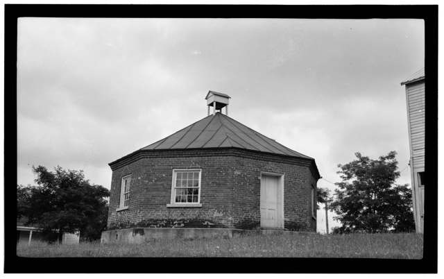
Photo: Eugene F. Schrand, Historic American Buildings Survey, Library of Congress, via Wikimedia Commons, public domain · Wikimedia Commons
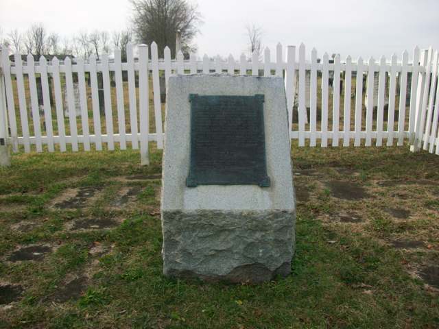
Photo: Aesopposea, via Wikimedia Commons, CC BY-SA 3.0 · Wikimedia Commons
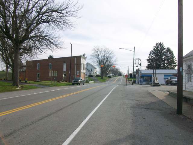
Photo: Aesopposea, via Wikimedia Commons, CC BY-SA 3.0 · Wikimedia Commons
Local history sources: en.wikipedia.org · en.wikipedia.org · en.wikipedia.org · en.wikipedia.org · timesgazette.com · roadsideamerica.com · en.wikipedia.org · en.wikipedia.org · commons.wikimedia.org · commons.wikimedia.org · commons.wikimedia.org · archive.org
Water
No water-system data is linked to Sinking Spring's ZIP codes yet.
Hospitals, fire stations and more
Inside Sinking Spring's boundary: 1 fire or EMS station. Press a pin or a name for its whole record and its source.
Fire and EMS stations (1)
-
Brushcreek Township Fire DepartmentSinking Spring
- Address
- 7 North Chestnut Street, Sinking Spring, OH 45172
- Coordinates
- 39.07448, -83.38483
USGS National Map structures (source) ↗ Street map and directions ↗
Source: USGS National Map structures (most Ohio records last updated 2019 to 2022), checked against the Columbus and Cleveland station lists. The department that answers a call is set by jurisdiction and mutual aid, not by distance.
Its ZIP codes
Each ZIP code that touches Sinking Spring, with the share of its residents who live here and the same headline figures as the ZIP page.
| ZIP | Share | Water | Radon | Home value | Schools | Flood |
|---|---|---|---|---|---|---|
| 45172 Sinking Spring | 100% | Mostly private wells | Too few radon tests | Appraisal records without year built | Adams County/Ohio Valley Local · 3 stars overall | 0.0% of residents in the 1% floodplain |
Local government
The state auditor's record.
Auditor of State record
- No fiscal caution, watch or emergency on the Auditor of State's lists.
- Basic Audit, 2023 to 2024, released 2025-07-29
On the November 3, 2026 ballot
Statewide question: State Issue 3: Voter ID
Races, candidates and every question for an address: your ballot. County offices and judges are on your county board's sample ballot.
The county
Highland County: 7 ZIP codes, 26 cities, villages and townships with pages here, 43,823 people (Census Bureau estimate, July 2025).
Nearby places
No nearby place shares a ZIP code with Sinking Spring in the atlas yet.
Rain and snow
How much has actually fallen on Sinking Spring, day by day, from 1893 to now. Daily totals, not averages.
- rain, last 30 days
- 1.28 in
- 2026-10-02 to 2026-10-31
- rain so far in 2026
- 38.1 in
- about normal for the date
- snow so far in 2026
- 15.0 in
- a normal year brings 17.7 in
- a normal year
- 44.8 in
- average of 30 years, 1991-2020
| Month | Rain (in) | Snow (in) | Days counted |
|---|---|---|---|
| October 2026 | 1.28 | — | 31 |
| September 2026 | 6.14 | — | 30 |
| August 2026 | 5.28 | — | 31 |
| July 2026 | 3.35 | — | 31 |
| June 2026 | 4.49 | — | 30 |
| May 2026 | 5.67 | — | 31 |
| April 2026 | 3.37 | — | 30 |
| March 2026 | 5.97 | 0.7 | 31 |
| February 2026 | 0.94 | 6.2 | 28 |
| January 2026 | 1.65 | 8.1 | 31 |
| December 2025 | 2.48 | 9.1 | 31 |
| November 2025 | 3.67 | 2.7 | 30 |
| Wettest year (estimated) | 2018 — 59.5 in |
|---|---|
| Driest year (estimated) | 1901 — 27.0 in |
| Wettest day (estimated) | 10 March 1964 — 4.65 in |
| Heaviest snowfall in a day (estimated) | 6 January 1910 — 11.76 in |
| Deepest snow on the ground (estimated) | 21 January 1978 — 21.02 in |
Estimated, not measured. No rain gauge has ever stood inside Sinking Spring, so every figure here is worked out from the gauges around it - the nearest ones weighted most. Treat them as close estimates rather than readings.
48,844 days of records, 1893-01-01 to 2026-10-31. Source: NOAA NCEI GHCN-Daily, 3,240 gauges in and around Ohio. A day is "gauged" when a gauge standing inside the boundary reported it, and the value is the mean of those gauges. Otherwise it is interpolated by inverse distance from every gauge reporting within 50 miles. Nothing is carried forward, back-filled or smoothed. Against NOAA nClimDiv county monthly precipitation over 136,848 complete county-months (checked 2026-11-02): correlation 0.9515, median absolute difference 0.217 in a month. Built 2026-11-02 from the Cracked Buckeye precipitation archive. Snow is the softer number — snowfall is measured by hand with a ruler, no agency publishes a gridded county snowfall series, and blowing snow defeats every observer.
Environmental permits and filings
What Ohio EPA has on file for Sinking Spring: permits, inspections, violations, cleanups and the state loans behind sewer and water work. Every line links to the agency's own document.
- facilities and sites on file
- 1
- those placed on the map inside Sinking Spring
| Program | Facilities and sites |
|---|---|
| Wastewater and stormwater discharge | 1 |
| Date | Facility or site | What |
|---|---|---|
| PATHWAY TO CHRIST CHURCH | Wastewater and stormwater discharge inspection |
Source: Ohio EPA eDocument portal (edocpub.epa.ohio.gov), indexed 2026-10-14. Facilities are placed on the map from Ohio EPA's own map layers, EPA's Facility Registry, coordinates written in the filings, or a geocoded street address. A permit filed under a private person's name (most are household septic systems) is counted but never named, placed or linked; licenses for individual workers and open-burning notices are left out entirely.
Quick answers
What county is Sinking Spring, Ohio in?
Sinking Spring is a village in Highland County, Ohio, with 116 residents.
When was Sinking Spring, Ohio founded?
Sinking Spring was settled 1796; laid out 1815. Founders on record: Jacob Hiestand (1815 plat); John Wilcoxson was the first settler. Source
How did Sinking Spring, Ohio get its name?
The village was named for a losing stream — one that disappears underground — near the original town site. Source
What ZIP code is Sinking Spring, Ohio?
Most of Sinking Spring is in ZIP code 45172.
Where does Sinking Spring, Ohio get its water?
The main water source for Sinking Spring: Mostly private wells.
Cite this page
Cite this page as:
Cracked Buckeye, "Sinking Spring, Highland County", https://crackedbuckeye.com/place/sinking-spring/, built 2026-11-02, accessed [date].
How to cite · Report a correction · Built 2026-11-02