Local events in Saint Marys
22 events in the next 90 days from 2 public calendars. All local events in Saint Marys
Checked October 20; the events page is refreshed daily.
How Saint Marys began
St. Marys sits at the portage between the St. Marys and Auglaize rivers, a strategic spot the Shawnee occupied as a trading village called Girty's Town before General Anthony Wayne built Fort St. Marys there in 1795. The modern town was platted in 1823 by Charles Murray, William Houston and John McCorkle, became a boomtown when the Miami and Erie Canal reached it in the 1840s, and served as Mercer County seat before Auglaize County was organized in 1848. It is now a city of about 8,400 on Grand Lake St. Marys, once the largest artificial lake in the world.
Settled 1823, platted 1823, incorporated 1834 (town), 1904 (city), by Charles Murray, William Houston, and John McCorkle.
Where the name comes from
The town and river take their name from Fort St. Marys, built in October 1795 and named for the St. Marys River; the river's own name has been traced to a French mission-era dedication rendered by later traders and settlers.
Before the town
Before American settlement the site was a Shawnee village that became known as Girty's Town for traders James and Simon Girty, who ran a trading post there from about 1783 to 1790; James Girty had earlier partnered with trader Peter Loramie until Loramie's post was burned in 1782. General Anthony Wayne passed through after the Battle of Fallen Timbers (1794) and found the village abandoned; recognizing the portage between the St. Marys and Auglaize rivers as strategically valuable, he ordered a fort built, and Fort St. Marys went up under Lieutenant John Michael in October 1795, shortly after the Treaty of Greenville. The town hosted two further Indian treaties confirming later land cessions in the region.
Nations recorded here: Shawnee.
- Girty's Town / Fort St. Marys site (village) — downtown St. Marys, at the St. Marys-Auglaize portage, pre-1790 to 1795 (village); 1795-1812 (fort) (hmdb.org)
Timeline
- — James and Simon Girty operate a trading post at the Shawnee village known as Girty's Town, on the site of present St. Marys.
- — Fort St. Marys is built in October by a detachment under Lt. John Michael following the Treaty of Greenville.
- — General William Henry Harrison finds the original fort in ruins and has Fort Barbee built nearby under Col. Joshua Barbee.
- — The earliest permanent settlers of the future town arrive.
- — St. Marys is formally platted by Charles Murray, William Houston and John McCorkle on 400 acres, 68 lots.
- — St. Marys serves as the seat of Mercer County.
- — St. Marys incorporates as a town; Judge Stacy Taylor becomes first mayor.
- — The Miami and Erie Canal, connecting the Ohio River to Lake Erie, reaches St. Marys and brings a boom in trade.
- — Auglaize County is organized; Wapakoneta, not St. Marys, wins the popular vote for county seat after German Township's returns, thought to favor St. Marys, are never handed in.
- — St. Marys becomes a city on exceeding 5,000 residents.
Stories
A town that lost the county seat by a vote
By the 1840s St. Marys was the larger, more established town in the area that would become Auglaize County, with a canal-fed economy and a history as a county seat already, for Mercer County. When Auglaize County was carved out of Allen, Mercer and other neighboring counties in 1848, St. Marys expected to be chosen as seat, and the question went to the voters. German Township, thought to favor St. Marys, never had its returns handed in with the rest, and Wapakoneta, which argued its more central location, won a clear majority without them. The 1880 county history says the rivalry turned into lasting enmity between the two towns.
From a burned trading post to a fort at the portage
Trader James Girty first worked with Peter Loramie at a post to the south, but fled north to the St. Marys River after Kentucky militia burned Loramie's store in 1782. He and his brother Simon ran a trading post at the Shawnee village here through the turbulent years of the early 1790s, until Girty fled again as General Josiah Harmar's army approached. When Anthony Wayne came through in late 1794, after his victory at Fallen Timbers, he found the village deserted but recognized the site's value: it sat on the short portage between the St. Marys and Auglaize rivers, letting boats move between the Maumee and Great Miami watersheds. He ordered a fort built, and Fort St. Marys rose there in October 1795, the same year as the Treaty of Greenville.
Photographs
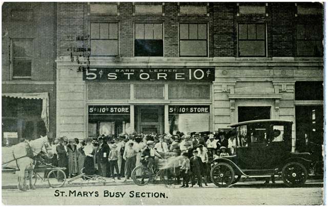
Photo: Columbus Metropolitan Library, via Digital Public Library of America / Ohio Digital Network, no known copyright restrictions · Wikimedia Commons
Local history sources: en.wikipedia.org · hmdb.org · en.wikipedia.org · cityofstmarys.net · www2.auglaizecounty.org · islands.com · archive.org · en.wikipedia.org · commons.wikimedia.org
Historic places
3 places in Saint Marys on the National Register of Historic Places. Press a pin or a name for its whole record.
-
Fountain Hotel, TheBuilding · St. Marys · listed 1997
- Address
- 100-110 W. Spring St.
- Where
- St. Marys, Auglaize County · ZIP 45885
- What it is
- Building
- Listed on the National Register
- 1997
- NRIS reference number
- 97001564
- Coordinates
- 40.54293, -84.38874
National Register file (NPS) ↗ Search Wikipedia ↗ Street map and directions ↗ On the Cracked Buckeye map
-
Holy Rosary Catholic ChurchBuilding · St. Marys · listed 1979
- Address
- jct. E Spring and S Pine Sts.
- Where
- St. Marys, Auglaize County · ZIP 45885
- What it is
- Building
- Listed on the National Register
- 1979
- NRIS reference number
- 79003456
- Coordinates
- 40.54513, -84.38269
National Register file (NPS) ↗ Search Wikipedia ↗ Street map and directions ↗ On the Cracked Buckeye map
-
Williams, Dr. Issac Elmer, House And OfficeBuilding · St. Marys · listed 1979
- Address
- 407--411 N. Main St.
- Where
- St. Marys, Auglaize County · ZIP 45885
- What it is
- Building
- Listed on the National Register
- 1979
- NRIS reference number
- 79001785
- Coordinates
- 40.54554, -84.39259
National Register file (NPS) ↗ Search Wikipedia ↗ Street map and directions ↗ On the Cracked Buckeye map
Source: National Park Service, National Register of Historic Places point file. The listing year is shown where NPS's certification date agrees with the listing's reference number. Listing recognizes significance; it does not restrict a private owner.
Water
Teays River Buried Valley Aquifer (wells) The water here
- St. Marys City100% of residentsTeays River Buried Valley Aquifer (wells)
Hospitals, fire stations and more
Inside Saint Marys's boundary: 1 hospital, 3 nursing homes, 1 fire or EMS station, 1 power plant, 4 public schools, 1 private school, 1 library, 1 museum, 1 police station, 1 public charging site, 8 Toxics Release Inventory facilities and 1 spill case. Press a pin or a name for its whole record and its source.
Hospitals (1)
-
Joint Township District Memorial HospitalGeneral hospital · Saint Marys
- What it is
- General hospital
- Address
- 200 Saint Clair Ave, Saint Marys, OH 45885
- County
- Auglaize County
- Beds
- 140
- Helipad
- Yes
- Ownership
- Non-profit
- Medicare overall rating
- 4 of 5 stars
- Emergency department (Medicare)
- Yes
- Medicare reports it as
- Grand Lake Health System
- Phone
- (419) 394-3335
- Medicare ID
- 360032
Medicare Care Compare ↗ Hospital's website ↗ Where HIFLD got this record ↗ HIFLD hospitals (source) ↗ Street map and directions ↗
Source: HIFLD hospitals inventory via FEMA (closed hospitals it still lists left out, hospitals opened since added), with Medicare Care Compare ratings matched by name and address.
Nursing homes (3)
-
Grande Lake Healthcare Center3 of 5 stars · St Marys
- Address
- 1209 Indiana Avenue, St Marys, OH 45885
- Certified beds
- 45
- Residents on an average day
- 43
- Medicare overall rating
- 3 of 5 stars
- Health inspections
- 3 of 5 stars
- Staffing
- 2 of 5 stars
- Quality measures
- 4 of 5 stars
- Penalties since 2023
- none
- Ownership
- For profit - Corporation
- Chain
- COMMUNICARE HEALTH
- Takes
- Medicare and Medicaid
- Phone
- (419) 394-7611
- Medicare ID
- 365809
Medicare Care Compare ↗ CMS nursing home data (source) ↗ Street map and directions ↗
-
Transitional Care Unit4 of 5 stars · Saint Marys
- Address
- 200 St Clair Street, Saint Marys, OH 45885
- Certified beds
- 15
- Residents on an average day
- 4
- Medicare overall rating
- 4 of 5 stars
- Health inspections
- 4 of 5 stars
- Staffing
- 4 of 5 stars
- Quality measures
- 4 of 5 stars
- Penalties since 2023
- none
- Ownership
- Non profit - Other
- Takes
- Medicare
- Phone
- (419) 394-3335
- Medicare ID
- 365807
Medicare Care Compare ↗ CMS nursing home data (source) ↗ Street map and directions ↗
-
Vancrest of St Mary's5 of 5 stars · St Marys
- Address
- 1035 Hager Street, St Marys, OH 45885
- Certified beds
- 66
- Residents on an average day
- 43
- Medicare overall rating
- 5 of 5 stars
- Health inspections
- 5 of 5 stars
- Staffing
- 3 of 5 stars
- Quality measures
- 5 of 5 stars
- Penalties since 2023
- none
- Ownership
- For profit - Partnership
- Chain
- VANCREST HEALTH CARE CENTERS
- Continuing care retirement community
- Yes
- Takes
- Medicare and Medicaid
- Phone
- (419) 394-3308
- Medicare ID
- 365232
Medicare Care Compare ↗ CMS nursing home data (source) ↗ Street map and directions ↗
Source: CMS Care Compare nursing home provider and penalties files; Medicare star ratings run 1 to 5.
Fire and EMS stations (1)
-
Saint Marys Fire DepartmentSaint Marys
- Address
- 222 Indiana Avenue, Saint Marys, OH 45885
- Coordinates
- 40.54600, -84.39243
USGS National Map structures (source) ↗ Street map and directions ↗
Source: USGS National Map structures (most Ohio records last updated 2019 to 2022), checked against the Columbus and Cleveland station lists. The department that answers a call is set by jurisdiction and mutual aid, not by distance.
Power plants (1)
-
St MarysPetroleum · 22 MW
- Capacity
- 22 MW
- By fuel
- natural gas 10 MW, oil 12 MW
- Main source
- Petroleum
- Technology
- Natural Gas Fired Combustion Turbine; Petroleum Liquids;
- Operator
- City of St Marys - (OH)
- Sector
- Electric Utility
- Where
- St. Marys, Auglaize County
- Generating units
- 2
- Built
- 1992 (first unit); newest unit 1999
- EIA plant code
- 2942
EIA plant page ↗ EIA-860 (source) ↗ Street map and directions ↗
Source: EIA-860 power plant inventory via HIFLD (February 2025), with plant codes, units and years from EIA-860 2025.
Public schools (4)
-
St Marys Memorial High School3.5 of 5 stars · Saint Marys
- Address
- 2250 St Rt 66 N, Saint Marys, OH 45885
- School district
- St Marys City School District
- Kind (NCES)
- Regular School
- Students, 2023-24
- 625
- Teachers (full-time equivalent)
- 41.95
- Report card, 2025-26
- 3.5 of 5 stars
- Performance index
- 75.9%
- Four-year graduation rate
- 99.3%
- Ohio building IRN
- 024208
- NCES school ID
- 390447201585
NCES school record ↗ Ohio School Report Card ↗ Street map and directions ↗
-
St Marys West Intermediate School3.5 of 5 stars · Saint Marys
- Address
- 1301 W High St, Saint Marys, OH 45885
- School district
- St Marys City School District
- Kind (NCES)
- Regular School
- Students, 2023-24
- 417
- Teachers (full-time equivalent)
- 21.14
- Report card, 2025-26
- 3.5 of 5 stars
- Performance index
- 82%
- Ohio building IRN
- 040337
- NCES school ID
- 390447201588
NCES school record ↗ Ohio School Report Card ↗ Street map and directions ↗
-
St. Marys East Primary School3 of 5 stars · Saint Marys
- Address
- 650 Armstrong St, Saint Marys, OH 45885
- School district
- St Marys City School District
- Kind (NCES)
- Regular School
- Students, 2023-24
- 445
- Teachers (full-time equivalent)
- 25.43
- Report card, 2025-26
- 3 of 5 stars
- Ohio building IRN
- 009308
- NCES school ID
- 390447201583
NCES school record ↗ Ohio School Report Card ↗ Street map and directions ↗
-
St. Marys Middle School3.5 of 5 stars · Saint Marys
- Address
- 2250 St Rt 66 N, Saint Marys, OH 45885
- School district
- St Marys City School District
- Kind (NCES)
- Regular School
- Students, 2023-24
- 433
- Teachers (full-time equivalent)
- 24.47
- Report card, 2025-26
- 3.5 of 5 stars
- Performance index
- 75.9%
- Ohio building IRN
- 023390
- NCES school ID
- 390447201584
NCES school record ↗ Ohio School Report Card ↗ Street map and directions ↗
Source: NCES EDGE public school locations 2024-25 and Common Core of Data 2023-24 (type, students, teachers); Ohio School Report Cards 2025-26 (Department of Education and Workforce), matched by name within the district.
Private schools (1)
-
Holy Rosary Elementary SchoolPrivate, Catholic · Saint Marys
- Address
- 128 S Pine St, Saint Marys, OH 45885
- Kind
- Catholic
- Students, 2023-24
- 115
- Teachers (full-time equivalent)
- 11.6
- Students per teacher
- 9.91379
- Phone
- (419) 394-5291
- NCES private school ID
- 01056391
Source: NCES Private School Survey 2023-24.
Public libraries (1)
-
St. Marys Community Public LibraryCentral library · St. Marys
- Address
- 140 S. Chestnut St., St. Marys, OH 45885
- What it is
- Central library
- Library system
- St. Marys Community Public Library
- Open
- 2,600 hours a year, 52 weeks
- Building
- 13,039 sq ft
- System's visits, FY2024
- 42,120
- System's loans, FY2024
- 112,358
- People the system serves
- 13,409
- Phone
- (419) 394-7471
IMLS Public Libraries Survey (source) ↗ Street map and directions ↗
Source: IMLS Public Libraries Survey FY2024 (outlets and their systems). Any Ohio resident can get a free card at any Ohio public library.
Museums, historical societies, gardens and zoos (1)
-
Gasoline Alley MuseumMuseum · Saint Marys
- What it is
- Museum
- City
- Saint Marys
- Coordinates
- 40.54442, -84.40664
Search Wikipedia ↗ IMLS Museum Data Files (source) ↗ Street map and directions ↗
The museum list is IMLS's 2018 file; a museum may have closed or moved since.
Source: IMLS Museum Data Files, 2018.
Police stations (1)
-
Saint Marys Police DepartmentSaint Marys
- Address
- 222 Indiana Avenue, Saint Marys, OH 45885
- Coordinates
- 40.54622, -84.39241
USGS National Map structures (source) ↗ Street map and directions ↗
Source: USGS National Map structures, police stations, corrected and completed by hand (September 2026). The department that answers a call is set by jurisdiction, not by distance.
Public EV charging (1)
-
ST MARYS SQUARE ST MARYS SQUARE2 Level 2 · Saint Marys
- Address
- 1220 Indiana Ave, Saint Marys, OH 45885
- Ports
- 2 Level 2
- Plugs
- J1772
- Network
- ChargePoint Network
- Hours
- 24 hours daily
- Phone
- 888-758-4389
Station Locator (NREL) ↗ Alternative Fuels Data Center (source) ↗ Street map and directions ↗
Source: NREL Alternative Fuels Data Center station list (May 2026), public and open stations, the posts at one address counted as one site.
Facilities reporting toxic releases (8)
-
Cargill IncToxics Release Inventory · Saint Marys
- Address
- 1400 Mckinley Rd, Saint Marys, OH 45885
- County
- Auglaize County
- Status
- Reports to the Toxics Release Inventory (active)
- EPA program ID
- 45885STMRY1400M
- EPA registry ID
- 110000395947
EPA facility record ↗ EPA Facility Registry Service (source) ↗ Street map and directions ↗
-
Kosei St. Marys, Corp.Toxics Release Inventory · Saint Marys
- Address
- 1100 Mckinley Rd., Saint Marys, OH 45885
- County
- Auglaize County
- Status
- Reports to the Toxics Release Inventory
- EPA program ID
- 45885PSTMR1100M
- EPA registry ID
- 110000395938
EPA facility record ↗ EPA Facility Registry Service (source) ↗ Street map and directions ↗
-
Loc Performance Products LlcToxics Release Inventory · St. Marys
- Address
- 1115 South Wayne Street, St. Marys, OH 45885
- County
- Auglaize County
- Status
- Reports to the Toxics Release Inventory (open)
- EPA program ID
- 45885THGDY1115S
- EPA registry ID
- 110000395974
EPA facility record ↗ EPA Facility Registry Service (source) ↗ Street map and directions ↗
-
Murotech Ohio CorpToxics Release Inventory · Saint Marys
- Address
- 550 Mckinley Rd, Saint Marys, OH 45885
- County
- Auglaize County County
- Status
- Reports to the Toxics Release Inventory
- EPA program ID
- 4588WMRTCH55MCK
- EPA registry ID
- 110046574738
EPA facility record ↗ EPA Facility Registry Service (source) ↗ Street map and directions ↗
-
Parker Hannifin Corp Cylinder DivToxics Release Inventory · Saint Marys
- Address
- 1880 Celina Rd., Saint Marys, OH 45885
- County
- Auglaize County
- Status
- Reports to the Toxics Release Inventory (active)
- EPA program ID
- 45885PRKRH1880C
- EPA registry ID
- 110000395929
EPA facility record ↗ EPA Facility Registry Service (source) ↗ Street map and directions ↗
-
Parker Hannifin Corp Cylinder DivToxics Release Inventory · Saint Marys
- Address
- 1700 E Spring St, Saint Marys, OH 45885
- County
- Auglaize County
- Status
- Reports to the Toxics Release Inventory (active)
- EPA program ID
- 45885PRKRH1700E
- EPA registry ID
- 110008057878
EPA facility record ↗ EPA Facility Registry Service (source) ↗ Street map and directions ↗
-
St. Marys Foundry Inc. (0306010004)Toxics Release Inventory · Saint Marys
- Address
- 405 E. South St., Saint Marys, OH 45885
- County
- Auglaize County
- Status
- Reports to the Toxics Release Inventory (active)
- EPA program ID
- 45885STMRY40540
- EPA registry ID
- 110005987487
EPA facility record ↗ EPA Facility Registry Service (source) ↗ Street map and directions ↗
-
St. Marys Municipal Power PlantToxics Release Inventory · Saint Marys
- Address
- 335 N. Chestnut St., Saint Marys, OH 45885
- County
- Auglaize County
- Status
- Reports to the Toxics Release Inventory (active)
- EPA program ID
- 45885STMRY335NC
- EPA registry ID
- 110000395956
EPA facility record ↗ EPA Facility Registry Service (source) ↗ Street map and directions ↗
Source: EPA Facility Registry Service, Toxics Release Inventory reporters. Reporting a release is required of large users of listed chemicals; it is not by itself a violation.
Spills reported since 2021 (1)
-
Chemical(S) Unk2021-08-09 · Saint Marys
- Reported
- 2021-08-09
- What spilled
- Chemical(S) Unk
- Where
- Saint Marys, Auglaize County
- Ohio EPA district office
- NWDO
- Ohio EPA case number
- 2108EPA0001210
Ohio EPA spill reports (source) ↗ Street map and directions ↗
Source: Ohio EPA emergency response spill reports, 2021 to September 2026, one point per case where Ohio EPA placed it. A report is what the caller or responder recorded; amounts are often blank or estimated.
Its ZIP codes
Each ZIP code that touches Saint Marys, with the share of its residents who live here and the same headline figures as the ZIP page.
| ZIP | Share | Water | Radon | Home value | Schools | Flood |
|---|---|---|---|---|---|---|
| 45885 Saint Marys | 65% | Teays River Buried Valley Aquifer (wells) | 3.8 pCi/L average radon | Appraisal records without year built | St. Marys City · 3.5 stars overall | 14% of residents in the 1% floodplain |
Local government
Who holds office in Saint Marys, how its elections and ballot issues came out, and the state auditor's record.
Who holds office
| Office | Name | Party | Term ends | Contact |
|---|---|---|---|---|
| Mayor | Joseph Hurlburt Jr. | 12/31/27 | 419-300-1241 · jhurlburt@cityofstmarys.net 101 W Spring Street, St. Marys, OH 45885 · website | |
| Council President | James J. Harris | 12/31/27 | 419-394-3625 · jjharris@bright.net 101 W Spring Street, St. Marys, OH 45885 · website | |
| At-Large Council Member | Bob Fitzgerald | 12/31/27 | 419-305-9822 · balfitz@bright.net 101 W Spring Street, St. Marys, OH 45885 · website | |
| At-Large Council Member | Michael Aquaro Jr. | 12/31/27 | 419-305-4943 · michaelaquaro1@gmail.com 101 W Spring Street, St. Marys, OH 45885 · website | |
| At-Large Council Member | Aaron Gilliland | 12/31/27 | 419-852-0725 · aarongilliland.stmaryscouncil@gmail.com 101 W Spring Street, St. Marys, OH 45885 · website | |
| 1st Ward Council Member | John Bubp | 12/31/27 | 419-953-7171 · jabubp@bright.net 101 W Spring Street, St. Marys, OH 45885 · website | |
| 2nd Ward Council Member | David Lunz | 12/31/27 | 419-300-5623 · dl64@bright.net 101 W Spring Street, St. Marys, OH 45885 · website | |
| 3rd Ward Council Member | Josie Slater | 12/31/27 | 419-300-9193 · xman11@bright.net 101 W Spring Street, St. Marys, OH 45885 · website | |
| 4th Ward Council Member | Erik Mauter | 12/31/27 | 419-394-0863 · erikmauter@gmail.com 101 W Spring Street, St. Marys, OH 45885 · website | |
| Auditor | Douglas M. Riesen | 12/31/27 | 419-300-3110 · driesen@cityofstmarys.net 101 W Spring Street, St. Marys, OH 45885 · website | |
| Treasurer | Kathy Fleagle | 12/31/29 | 419-300-3109 · kfleagle@cityofstmarys.net 101 W Spring Street, St. Marys, OH 45885 · website | |
| Law Director | Jeffrey P. Squire | 12/31/27 | 419-394-7441 · jsquire@nmmlawyers.com 101 W Spring Street, St. Marys, OH 45885 · website |
Roster as of 2026-09-18: county board of elections.
Elections for office
| Date | Office | Candidates and votes |
|---|---|---|
| 2023-11-07 | President of Council (unofficial count) | James J. Harris (REP) 2,042, 100.0% |
| 2023-11-07 | Member of Council, Ward 3 (unofficial count) | James S. Christman (REP) 427, 100.0% |
| 2023-11-07 | Member of Council, Ward 2 (unofficial count) | David A. Thomas 318, 38.08%; Kyle A. Schmehl (REP) 517, 61.92% |
| 2023-11-07 | Mayor (unofficial count) | Ashley Randolph 698, 27.37%; Joe Hurlburt (REP) 1,852, 72.63% |
| 2023-11-07 | Director of Law (unofficial count) | Zach G. Ferrall (REP) 2,086, 100.0% |
| 2021-11-02 | Treasurer (unofficial count) | Kathy Fleagle 437, 48.56%; Frank Thomas 463, 51.44% |
| 2021-11-02 | President of Council (unofficial count) | James J. Harris (REP) 782, 100.0% |
| 2021-11-02 | Member of Council at Large (unofficial count) | Robert J. Fitzgerald (REP) 625, 34.04%; Todd Fleagle (REP) 594, 32.35%; Dan Uhlenhake (REP) 617, 33.61% |
Winners in bold. Results from the county board of elections' official canvass unless marked.
Auditor of State record
- No fiscal caution, watch or emergency on the Auditor of State's lists.
- Financial Health Indicators (the Auditor of State's 17 measures; critical / cautionary / positive): 2020 1 / 4 / 12; 2021 5 / 2 / 10; 2022 1 / 4 / 12; 2023 1 / 5 / 11; 2024 3 / 2 / 12; 2025 5 / 3 / 8.
- Agreed Upon Procedures, 2024, released 2025-12-18
- Agreed Upon Procedures, 2023, released 2024-09-05
The county
Auglaize County: 10 ZIP codes, 21 cities, villages and townships, 45,348 people.
Nearby places
Rain and snow
How much has actually fallen on Saint Marys, day by day, from 1893 to now. Daily totals, not averages.
- rain, last 30 days
- 0.75 in
- 2026-09-30 to 2026-10-29
- rain so far in 2026
- 39.8 in
- 5.9 in above normal for the date
- snow so far in 2026
- 17.2 in
- a normal year brings 20.8 in
- a normal year
- 39.8 in
- average of 30 years, 1991-2020
| Month | Rain (in) | Snow (in) | Days counted |
|---|---|---|---|
| October 2026 | 0.75 | — | 29 |
| September 2026 | 7.52 | — | 30 |
| August 2026 | 9.09 | — | 31 |
| July 2026 | 2.79 | — | 31 |
| June 2026 | 3.81 | — | 30 |
| May 2026 | 4.67 | — | 31 |
| April 2026 | 4.78 | — | 30 |
| March 2026 | 4.51 | 1.2 | 31 |
| February 2026 | 0.73 | 4.7 | 28 |
| January 2026 | 1.14 | 11.3 | 31 |
| December 2025 | 1.36 | 8.4 | 31 |
| November 2025 | 1.51 | 4.9 | 30 |
| Wettest year | 2011 — 56.1 in |
|---|---|
| Driest year | 1963 — 21.5 in |
| Snowiest year | 2014 — 54.0 in |
| Wettest day on record | 13 July 1992 — 5.75 in |
| Heaviest snowfall in a day | 26 November 1950 — 14.99 in |
| Deepest snow on the ground | 2 March 1912 — 37.99 in |
Mostly estimated. Only 2% of these days come from a gauge standing inside Saint Marys - the rest are worked out from the nearest gauges around it, so read them as close estimates rather than readings.
48,868 days of records, 1893-01-01 to 2026-10-29. Source: NOAA NCEI GHCN-Daily, 3,240 gauges in and around Ohio. A day is "gauged" when a gauge standing inside the boundary reported it, and the value is the mean of those gauges. Otherwise it is interpolated by inverse distance from every gauge reporting within 50 miles. Nothing is carried forward, back-filled or smoothed. Against NOAA nClimDiv county monthly precipitation over 136,848 complete county-months (checked 2026-10-31): correlation 0.9515, median absolute difference 0.217 in a month. Built 2026-10-31 from the Cracked Buckeye precipitation archive. Snow is the softer number — snowfall is measured by hand with a ruler, no agency publishes a gridded county snowfall series, and blowing snow defeats every observer.
Environmental permits and filings
What Ohio EPA has on file for Saint Marys: permits, inspections, violations, cleanups and the state loans behind sewer and water work. Every line links to the agency's own document.
- facilities and sites on file
- 67
- those placed on the map inside Saint Marys
Data centers, power and big tech here. Ohio EPA files that name a data-center company, a power plant or substation, or a large technology firm:
- SAINT MARYS MUNICIPAL POWER PLANT (air pollution, latest Aug 3, 2026)
| Program | Facilities and sites |
|---|---|
| Wastewater and stormwater discharge | 17 |
| Hazardous waste | 15 |
| Sewer and water-line construction | 10 |
| Voluntary cleanup | 9 |
| Air pollution | 8 |
| Beneficial Use | 1 |
| Brownfield | 1 |
| Contaminated-site cleanup | 1 |
| Medical waste | 1 |
| Public drinking water | 1 |
| Site assessment | 1 |
| State sewer loans | 1 |
| 1 smaller programs |
| Date | Facility or site | What |
|---|---|---|
| REGIONAL CREMATION ALLIANCE LLC | Air pollution report | |
| ST MARYS CITY WWTP | Wastewater and stormwater discharge report | |
| ST MARYS CITY PWS | Public drinking water compliance letter | |
| ST MARYS CITY PWS | Public drinking water notice of violation | |
| SUNDAY'S | Wastewater and stormwater discharge inspection | |
| SAINT MARYS FOUNDRY CO | Wastewater and stormwater discharge violation resolved | |
| ST MARYS CITY PWS | Public drinking water notice of violation | |
| SAINT MARYS MUNICIPAL POWER PLANT | Air pollution permit | |
| SPRING STREET PID 120199 | Wastewater and stormwater discharge permit | |
| CARGILL INCORPORATED | Air pollution permit | |
| SAINT MARYS MUNICIPAL POWER PLANT | Air pollution notice of violation | |
| ST MARYS CITY WWTP | Wastewater and stormwater discharge plan | |
| SAINT MARYS MUNICIPAL POWER PLANT | Air pollution permit | |
| CARGILL INCORPORATED | Air pollution report | |
| ST MARYS CITY PWS | Public drinking water report | |
| CARGILL INCORPORATED | Air pollution report | |
| SAINT MARYS MUNICIPAL POWER PLANT | Air pollution permit | |
| SUNDAY'S | Wastewater and stormwater discharge permit | |
| ROUTE 33 EATS N' TREATS | Wastewater and stormwater discharge permit | |
| ST MARYS CITY WWTP | Wastewater and stormwater discharge report | |
| SAINT MARYS FOUNDRY CO | Voluntary cleanup inspection | |
| SAINT MARYS CITY | Beneficial Use permit | |
| ST MARYS CITY WWTP | Wastewater and stormwater discharge director's approval | |
| OMNI MANUFACTURING INC | Hazardous waste notice of violation | |
| SAINT MARYS CITY | Beneficial Use permit |
Source: Ohio EPA eDocument portal (edocpub.epa.ohio.gov), indexed 2026-10-14. Facilities are placed on the map from Ohio EPA's own map layers, EPA's Facility Registry, coordinates written in the filings, or a geocoded street address. A permit filed under a private person's name (most are household septic systems) is counted but never named, placed or linked; licenses for individual workers and open-burning notices are left out entirely.
Quick answers
What county is Saint Marys, Ohio in?
Saint Marys is a city in Auglaize County, Ohio, with 8,397 residents.
When was Saint Marys, Ohio founded?
Saint Marys was settled 1823; laid out 1823; incorporated 1834 (town), 1904 (city). Founders on record: Charles Murray, William Houston, and John McCorkle. Source
How did Saint Marys, Ohio get its name?
The town and river take their name from Fort St. Source
What ZIP code is Saint Marys, Ohio?
Most of Saint Marys is in ZIP code 45885.
Where does Saint Marys, Ohio get its water?
The main water source for Saint Marys (St. Marys City): Teays River Buried Valley Aquifer (wells).
Cite this page
Cite this page as:
Cracked Buckeye, "Saint Marys, Auglaize County", https://crackedbuckeye.com/place/saint-marys/, built 2026-10-31, accessed [date].
How to cite · Report a correction · Built 2026-10-31
