Local events in Rock Creek
12 events in the next 90 days from 2 public calendars. All local events in Rock Creek
Checked October 20; the events page is refreshed daily.
How Rock Creek began
Rock Creek village sits at the confluence of Rock Creek and the Grand River within Morgan Township, first settled in 1798 and organized in 1819 along with the wider township; the village itself incorporated separately on April 5, 1849. Ashtabula County's first Teachers' Institute convened here in November 1852, and the village built a substantial brick schoolhouse in 1869, later listed on the National Register of Historic Places. Theologian Lewis Sperry Chafer, born in Rock Creek on February 27, 1871, went on to co-found Dallas Theological Seminary in 1924 and wrote one of the twentieth century's most influential dispensationalist systematic theologies.
Settled 1798, incorporated April 5, 1849, by Grew from the Morgan Township settlement at the Rock Creek-Grand River confluence.
Where the name comes from
The village takes its name from Rock Creek, the stream that joins the Grand River at this point.
Before the town
No Native American village, trail, or site specific to Rock Creek village is documented in the sources consulted; an 1852 arrowhead discovery is recorded for the wider Morgan Township.
Timeline
- — The area at the confluence of Rock Creek and the Grand River is first settled, part of the wider Morgan Township settlement.
- — The surrounding township organizes; Rock Creek develops as one of its settlement centers.
- — Ashtabula County's first Teachers' Institute convenes at Rock Creek.
- — Rock Creek incorporates as a village.
- — A brick schoolhouse in the Neoclassical style is built in the village; it is later listed on the National Register of Historic Places.
- — Lewis Sperry Chafer is born in Rock Creek.
- — The Riverdale Road Covered Bridge, a 140-foot Town truss span, is built over the Grand River in Morgan Township near Rock Creek.
- — A photograph captures an excursion train stopped at Rock Creek Station, en route to Woodland Beach Park, with signage showing distances of 109.4 miles to Pittsburgh and 17.2 miles to the harbor.
- — Lewis Sperry Chafer co-founds Dallas Theological Seminary with William Henry Griffith Thomas, serving as its president and professor of Systematic Theology until his death in 1952.
- — Center steel bracing is added to reinforce the Riverdale Road Covered Bridge.
Stories
From a Rock Creek birth to a Dallas seminary
Lewis Sperry Chafer was born in the small village of Rock Creek on February 27, 1871, decades before anyone there could have guessed he would help reshape a whole strand of twentieth-century American Christianity. Chafer became a theologian associated with dispensationalism, a way of reading biblical history as a series of distinct eras or "dispensations" in God's dealing with humanity. In 1924 he co-founded Dallas Theological Seminary with William Henry Griffith Thomas, and led it as president and professor of Systematic Theology for the rest of his life. His crowning work, an eight-volume Systematic Theology completed in 1947, was the first attempt to lay out a full premillennial, dispensational theology in one systematic format -- successful enough to need a third printing within two years of publication. Chafer died in Seattle in 1952, but the seminary he helped found in Texas, and the theological framework he helped systematize, both trace back to a birth in a small Ashtabula County village most of their students would never visit.
Photographs
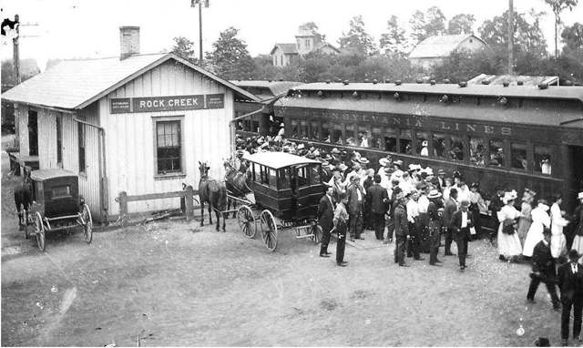
Photo: Ashtabula Archive, via Flickr and Wikimedia Commons, Public domain · Wikimedia Commons

Photo: Nyttend, via Wikimedia Commons, Public domain · Wikimedia Commons
Local history sources: en.wikipedia.org · en.wikipedia.org · en.wikipedia.org · conneautohio.us · commons.wikimedia.org · commons.wikimedia.org
Historic places
1 place in Rock Creek on the National Register of Historic Places. Press a pin or a name for its whole record.
-
Rock Creek SchoolBuilding · Rock Creek · listed 2005
- Address
- 2987 High St.
- Where
- Rock Creek, Ashtabula County · ZIP 44084
- What it is
- Building
- Listed on the National Register
- 2005
- NRIS reference number
- 05000023
- Coordinates
- 41.66290, -80.85804
National Register file (NPS) ↗ Search Wikipedia ↗ Street map and directions ↗ On the Cracked Buckeye map
Source: National Park Service, National Register of Historic Places point file. The listing year is shown where NPS's certification date agrees with the listing's reference number. Listing recognizes significance; it does not restrict a private owner.
Water
Mostly private wells The water here
- Roaming Shores Village59% of residentsLake Erie
- Rock Creek Village41% of residentsLake Erie
Hospitals, fire stations and more
Inside Rock Creek's boundary: 1 fire or EMS station, 1 public school, 1 library, 1 Superfund site and 2 Toxics Release Inventory facilities. Press a pin or a name for its whole record and its source.
Fire and EMS stations (1)
-
Morgan Hose Company Volunteer Fire DepartmentRock Creek
- Address
- 3033 East Water Street, Rock Creek, OH 44084
- Coordinates
- 41.66068, -80.85971
USGS National Map structures (source) ↗ Street map and directions ↗
Source: USGS National Map structures (most Ohio records last updated 2019 to 2022), checked against the Columbus and Cleveland station lists. The department that answers a call is set by jurisdiction and mutual aid, not by distance.
Public schools (1)
-
Rock Creek Elementary School3.5 of 5 stars · Rock Creek
- Address
- 3134 N Main St, Rock Creek, OH 44084
- School district
- Jefferson Area Local School District
- Kind (NCES)
- Regular School
- Students, 2023-24
- 305
- Teachers (full-time equivalent)
- 14.5
- Report card, 2025-26
- 3.5 of 5 stars
- Performance index
- 75.4%
- Ohio building IRN
- 032144
- NCES school ID
- 390458702373
NCES school record ↗ Ohio School Report Card ↗ Street map and directions ↗
Source: NCES EDGE public school locations 2024-25 and Common Core of Data 2023-24 (type, students, teachers); Ohio School Report Cards 2025-26 (Department of Education and Workforce), matched by name within the district.
Public libraries (1)
-
Rock Creek Public LibraryCentral library · Rock Creek
- Address
- 2988 High St., Rock Creek, OH 44084
- What it is
- Central library
- Library system
- Rock Creek Public Library
- Open
- 2,640 hours a year, 52 weeks
- Building
- 2,242 sq ft
- System's visits, FY2024
- 36,556
- System's loans, FY2024
- 39,217
- People the system serves
- 2,853
- Phone
- (440) 563-3340
IMLS Public Libraries Survey (source) ↗ Street map and directions ↗
Source: IMLS Public Libraries Survey FY2024 (outlets and their systems). Any Ohio resident can get a free card at any Ohio public library.
Superfund sites (1)
-
Old Mill NPLSuperfund, NPL · Rock Creek
- Address
- Mill Rd & Station, Rock Creek, OH 44084
- County
- Ashtabula County
- Status
- On the National Priorities List
- EPA program ID
- OHD980510200
- EPA registry ID
- 110060855579
EPA facility record ↗ EPA Facility Registry Service (source) ↗ Street map and directions ↗
Source: EPA Facility Registry Service, Superfund (SEMS) and National Priorities List sites. Many program sites were assessed and needed no cleanup.
Facilities reporting toxic releases (2)
-
Aleris Specialty Products Inc.- Rock Creek AluminumToxics Release Inventory · Rock Creek
- Address
- 2639 E. Water Street, Rock Creek, OH 44084
- County
- Ashtabula County
- Status
- Reports to the Toxics Release Inventory (active)
- EPA program ID
- 4408WLRSSP2639E
- EPA registry ID
- 110067130839
EPA facility record ↗ EPA Facility Registry Service (source) ↗ Street map and directions ↗
-
Rock Creek Aluminum IncToxics Release Inventory · Rock Creek
- Address
- 2639 E Water St, Rock Creek, OH 44084
- County
- Ashtabula County
- Status
- Reports to the Toxics Release Inventory (active)
- EPA program ID
- 44084RCKCR2639E
- EPA registry ID
- 110000386010
EPA facility record ↗ EPA Facility Registry Service (source) ↗ Street map and directions ↗
Source: EPA Facility Registry Service, Toxics Release Inventory reporters. Reporting a release is required of large users of listed chemicals; it is not by itself a violation.
Its ZIP codes
Each ZIP code that touches Rock Creek, with the share of its residents who live here and the same headline figures as the ZIP page.
| ZIP | Share | Water | Radon | Home value | Schools | Flood |
|---|---|---|---|---|---|---|
| 44084 Roaming Shores and Rock Creek | 18% | Mostly private wells | 2.6 pCi/L average radon | Parcel list only | Jefferson Area Local · 4.5 stars overall | 0.0% of residents in the 1% floodplain |
Local government
Who holds office in Rock Creek, how its elections and ballot issues came out, and the state auditor's record.
Money issues on the ballot since 2020: 3 of 3 passed.
Ballot issues
| Date | Issue | For | Against | Result |
|---|---|---|---|---|
| 2023-11-07 | 43: 43 Rock Creek Village 2M Roads (2.0 mills) | 118 | 61 | Passed (65.92% for) |
| 2023-11-07 | 48: 48 Sunday Sales Rock Creek Village VFW Post 4953 | 142 | 41 | Passed (77.6% for) |
| 2020-11-03 | 7: 7 Rock Creek Village 1.92M Operating Expenses (1.92 mills) | 189 | 81 | Passed (70.0% for) |
| 2020-11-03 | 8: 8 Rock Creek Village 2M Roads (2.0 mills) | 204 | 67 | Passed (75.28% for) |
Elections for office
| Date | Office | Candidates and votes |
|---|---|---|
| 2023-11-07 | Member of Council | James Hall 106, 36.81%; Suzanne Hayes 115, 39.93%; Robert Schultz 67, 23.26% |
| 2023-11-07 | Mayor | Shawnasee Burns 151, 100.0% |
| 2019-11-05 | Member of Council | James Hall 90, 36.89%; Suzanne Hayes 81, 33.2%; Barb Skytta 73, 29.92% |
| 2019-11-05 | Mayor | Shawn Burns 91, 59.48%; Robert Schultz 62, 40.52% |
Winners in bold. Results from the county board of elections' official canvass unless marked.
The county
Ashtabula County: 15 ZIP codes, 38 cities, villages and townships, 98,190 people.
Nearby places
Rain and snow
How much has actually fallen on Rock Creek, day by day, from 1893 to now. Daily totals, not averages.
- rain, last 30 days
- 1.18 in
- 2026-09-30 to 2026-10-29
- rain so far in 2026
- 33.0 in
- 4.5 in below normal for the date
- snow so far in 2026
- 64.9 in
- a normal year brings 85.8 in
- a normal year
- 44.7 in
- average of 30 years, 1991-2020
| Month | Rain (in) | Snow (in) | Days counted |
|---|---|---|---|
| October 2026 | 1.18 | — | 29 |
| September 2026 | 3.04 | — | 30 |
| August 2026 | 6.02 | — | 31 |
| July 2026 | 3.09 | — | 31 |
| June 2026 | 3.23 | — | 30 |
| May 2026 | 3.99 | 0.1 | 31 |
| April 2026 | 4.98 | 0.0 | 30 |
| March 2026 | 4.14 | 5.2 | 31 |
| February 2026 | 0.72 | 11.6 | 28 |
| January 2026 | 2.60 | 48.0 | 31 |
| December 2025 | 3.27 | 26.3 | 31 |
| November 2025 | 2.34 | 11.1 | 30 |
| Wettest year | 2011 — 64.9 in |
|---|---|
| Driest year | 1963 — 26.4 in |
| Snowiest year | 2005 — 128.8 in |
| Wettest day on record | 14 September 1979 — 4.76 in |
| Heaviest snowfall in a day | 17 January 2022 — 14.92 in |
| Deepest snow on the ground | 29 November 1950 — 25.57 in |
Estimated, not measured. No rain gauge has ever stood inside Rock Creek, so every figure here is worked out from the gauges around it - the nearest ones weighted most. Treat them as close estimates rather than readings.
48,542 days of records, 1893-01-01 to 2026-10-29. Source: NOAA NCEI GHCN-Daily, 3,240 gauges in and around Ohio. A day is "gauged" when a gauge standing inside the boundary reported it, and the value is the mean of those gauges. Otherwise it is interpolated by inverse distance from every gauge reporting within 50 miles. Nothing is carried forward, back-filled or smoothed. Against NOAA nClimDiv county monthly precipitation over 136,848 complete county-months (checked 2026-10-31): correlation 0.9515, median absolute difference 0.217 in a month. Built 2026-10-31 from the Cracked Buckeye precipitation archive. Snow is the softer number — snowfall is measured by hand with a ruler, no agency publishes a gridded county snowfall series, and blowing snow defeats every observer.
Environmental permits and filings
What Ohio EPA has on file for Rock Creek: permits, inspections, violations, cleanups and the state loans behind sewer and water work. Every line links to the agency's own document.
- facilities and sites on file
- 10
- those placed on the map inside Rock Creek
| Program | Facilities and sites |
|---|---|
| Contaminated-site cleanup | 3 |
| Hazardous waste | 2 |
| Wastewater and stormwater discharge | 2 |
| Air pollution | 1 |
| Public drinking water | 1 |
| Site assessment | 1 |
| Date | Facility or site | What |
|---|---|---|
| OLD MILL, ROCK CREEK | Contaminated-site cleanup cleanup response | |
| ROCK CREEK VILLAGE | Public drinking water inspection | |
| OLD MILL, ROCK CREEK | Contaminated-site cleanup cleanup response | |
| OLD MILL, ROCK CREEK | Contaminated-site cleanup cleanup cost recovery | |
| ROCK CREEK VILLAGE | Public drinking water compliance letter | |
| OLD MILL, ROCK CREEK | Contaminated-site cleanup cleanup response | |
| ROCK CREEK VILLAGE | Public drinking water violation resolved | |
| ROCK CREEK VILLAGE PWS | Public drinking water compliance letter | |
| OLD MILL, ROCK CREEK | Contaminated-site cleanup cleanup response | |
| OLD MILL, ROCK CREEK | Contaminated-site cleanup cleanup response | |
| OLD MILL, ROCK CREEK | Contaminated-site cleanup cleanup response | |
| ROCK CREEK VILLAGE | Public drinking water inspection | |
| ROCK CREEK VILLAGE | Public drinking water notice of violation | |
| ROCK CREEK VILLAGE PWS | Public drinking water inspection | |
| OLD MILL, ROCK CREEK | Contaminated-site cleanup cleanup response | |
| OLD MILL, ROCK CREEK | Contaminated-site cleanup cleanup response | |
| OLD MILL, ROCK CREEK | Contaminated-site cleanup cleanup response | |
| OLD MILL, ROCK CREEK | Contaminated-site cleanup cleanup response | |
| OLD MILL, ROCK CREEK | Contaminated-site cleanup cleanup response | |
| OLD MILL, ROCK CREEK | Contaminated-site cleanup cleanup response | |
| OLD MILL, ROCK CREEK | Contaminated-site cleanup cleanup response | |
| OLD MILL, ROCK CREEK | Contaminated-site cleanup cleanup response | |
| OLD MILL, ROCK CREEK | Contaminated-site cleanup cleanup response | |
| OLD MILL, ROCK CREEK | Contaminated-site cleanup cleanup response | |
| ROCK CREEK VILLAGE | Public drinking water report |
Source: Ohio EPA eDocument portal (edocpub.epa.ohio.gov), indexed 2026-10-14. Facilities are placed on the map from Ohio EPA's own map layers, EPA's Facility Registry, coordinates written in the filings, or a geocoded street address. A permit filed under a private person's name (most are household septic systems) is counted but never named, placed or linked; licenses for individual workers and open-burning notices are left out entirely.
Quick answers
What county is Rock Creek, Ohio in?
Rock Creek is a village in Ashtabula County, Ohio, with 667 residents.
When was Rock Creek, Ohio founded?
Rock Creek was settled 1798; incorporated April 5, 1849. Founders on record: Grew from the Morgan Township settlement at the Rock Creek-Grand River confluence. Source
How did Rock Creek, Ohio get its name?
The village takes its name from Rock Creek, the stream that joins the Grand River at this point. Source
What ZIP code is Rock Creek, Ohio?
Most of Rock Creek is in ZIP code 44084.
Where does Rock Creek, Ohio get its water?
The main water source for Rock Creek (Roaming Shores Village): Mostly private wells.
Cite this page
Cite this page as:
Cracked Buckeye, "Rock Creek, Ashtabula County", https://crackedbuckeye.com/place/rock-creek/, built 2026-10-31, accessed [date].
How to cite · Report a correction · Built 2026-10-31
