Local events in Olmsted Falls
31 events in the next 90 days from 2 public calendars. All local events in Olmsted Falls
Checked October 20; the events page is refreshed daily.
How Olmsted Falls began
James Geer planted corn on the township's land in 1814 and moved his family into a log house there in 1815, becoming the first settler of what was then Township 6, Range 15 of the Connecticut Western Reserve, land Aaron Olmsted, a sea captain from East Hartford, had bought nearly half of. Organized as Lenox Township in 1823, it was renamed Olmsted Township that year in Aaron Olmsted's honor, a gesture his son Charles Hyde Olmsted repaid by shipping about 500 books from Connecticut by oxcart -- the founding collection remembered as the Oxcart Library. The village incorporated in 1856, doubled in size annexing the hamlet of Plum Creek in 1857, merged with Westview in 1971, and became Ohio's 231st city in 1972; its historic business district at Bagley and Columbia roads, the Grand Pacific Junction, still centers on an 1855 hotel building.
Settled 1814-1815 (James Geer, first settler), incorporated village, April 7, 1856; city, 1972 (merged with Westview in 1971 first), by James Geer (first settler); Aaron Olmsted (principal land purchaser, namesake).
Where the name comes from
The township organized in 1823 as Lenox Township; a resident then suggested renaming it Olmsted Township to honor Aaron Olmsted, the East Hartford, Connecticut sea captain who had bought nearly half the township's land after Connecticut sold the Western Reserve to the Connecticut Land Company in 1795. Aaron's son Charles Hyde Olmsted responded to the honor by sending the community roughly 500 books from Connecticut by oxcart, the founding gift remembered locally as the Oxcart Library.
Before the town
No source we reviewed identifies a specific, named Native American village, mound, or treaty site within present Olmsted Falls. The township lies in the Rocky River watershed, land ceded to the United States by the 1795 Treaty of Greenville and opened by Connecticut's 1795 sale of the Western Reserve to the Connecticut Land Company, the same transaction that let Aaron Olmsted buy his township land.
Nations recorded here: Lenape (Delaware), Wyandot.
Timeline
- — Connecticut sells the Western Reserve, including the future Olmsted Township, to the Connecticut Land Company; sea captain Aaron Olmsted of East Hartford later buys nearly half the township.
- — James Geer plants corn on the township's land, across the border from where he was then living.
- — James Geer and his family move into a log house in Township 6, Range 15, becoming its first settlers.
- — The township organizes as Lenox Township, then is renamed Olmsted Township to honor Aaron Olmsted; his son Charles Hyde Olmsted sends about 500 books by oxcart, founding the Oxcart Library.
- — The rail line that becomes the CSX tracks through Olmsted Falls is built.
- — The rail line that becomes the Norfolk Southern tracks through Olmsted Falls is built.
- — The Grand Pacific Hotel is built at what is now 8112 Columbia Road, later the anchor of the Grand Pacific Junction historic district.
- — Olmsted Falls incorporates as a village.
- — The village doubles in size, annexing the unincorporated hamlet of Plum Creek to the north.
- — Olmsted Falls merges with the community of Westview.
- — Olmsted Falls becomes Ohio's 231st city, its population having passed 5,000.
Stories
A name change repaid with an oxcart of books
When the township organized in 1823 it first took the name Lenox, but a resident proposed renaming it for Aaron Olmsted, the East Hartford sea captain who had bought nearly half its land after Connecticut sold the Western Reserve in 1795. Aaron's son, Charles Hyde Olmsted, was moved enough by the honor to send the young community a gift out of proportion to its size: about 500 books, hauled overland from Connecticut by oxcart, that became the settlement's founding library and are remembered today as the Oxcart Library -- a small-town origin story about a family name repaid in books rather than money.
Photographs
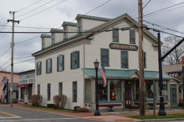
Photo: Nyttend (Wikimedia Commons), public domain · Wikimedia Commons
Local history sources: en.wikipedia.org · commons.wikimedia.org · en.wikipedia.org
Historic places
4 places in Olmsted Falls on the National Register of Historic Places. Press a pin or a name for its whole record.
-
Grand Pacific HotelBuilding · Olmsted Falls · listed 1975
- Address
- 8112 Columbia Rd.
- Where
- Olmsted Falls, Cuyahoga County · ZIP 44138
- What it is
- Building
- Listed on the National Register
- 1975
- NRIS reference number
- 75001369
- Coordinates
- 41.37427, -81.90196
National Register file (NPS) ↗ Search Wikipedia ↗ Street map and directions ↗ On the Cracked Buckeye map
-
Lay, Samuel, HouseBuilding · Olmsted Falls · listed 1979
- Address
- 7622 Columbia Rd.
- Where
- Olmsted Falls, Cuyahoga County · ZIP 44138
- What it is
- Building
- Listed on the National Register
- 1979
- NRIS reference number
- 79001814
- Coordinates
- 41.38011, -81.90348
National Register file (NPS) ↗ Search Wikipedia ↗ Street map and directions ↗ On the Cracked Buckeye map
-
Northrop, Julia Carter, HouseBuilding · Olmsted Falls · listed 1975
- Address
- 7872 Columbia Rd.
- Where
- Olmsted Falls, Cuyahoga County · ZIP 44138
- What it is
- Building
- Listed on the National Register
- 1975
- NRIS reference number
- 75001370
- Coordinates
- 41.37633, -81.90259
National Register file (NPS) ↗ Search Wikipedia ↗ Street map and directions ↗ On the Cracked Buckeye map
-
Olmsted Falls DepotBuilding · Olmsted Falls · listed 2000
- Address
- 25802 Garfield Rd.
- Where
- Olmsted Falls, Cuyahoga County · ZIP 44138
- What it is
- Building
- Listed on the National Register
- 2000
- NRIS reference number
- 00000963
- Coordinates
- 41.37487, -81.90580
National Register file (NPS) ↗ Search Wikipedia ↗ Street map and directions ↗ On the Cracked Buckeye map
Source: National Park Service, National Register of Historic Places point file. The listing year is shown where NPS's certification date agrees with the listing's reference number. Listing recognizes significance; it does not restrict a private owner.
Water
Lake Erie, through an 8-foot pipe running 2.5 miles offshore from the Westlake shoreline The water here
- Cleveland Public Water System92% of residentsLake Erie
- Rural Lorain Co. Water A8% of residentsMostly Lake Erie (bought from Avon Lake); some New London Reservoir and Ashland wells
Hospitals, fire stations and more
Inside Olmsted Falls's boundary: 2 nursing homes, 1 fire or EMS station, 1 public school, 1 private school, 1 library, 1 museum, 1 police station, 1 Toxics Release Inventory facility and 7 spill cases. Press a pin or a name for its whole record and its source.
Nursing homes (2)
-
Riverview Pointe Care Center5 of 5 stars · Olmsted Falls
- Address
- 9027 Columbia Road, Olmsted Falls, OH 44138
- Certified beds
- 124
- Residents on an average day
- 118
- Medicare overall rating
- 5 of 5 stars
- Health inspections
- 4 of 5 stars
- Staffing
- 2 of 5 stars
- Quality measures
- 5 of 5 stars
- Penalties since 2023
- none
- Ownership
- For profit - Corporation
- Chain
- FOUNDATIONS HEALTH SOLUTIONS
- Takes
- Medicare and Medicaid
- Phone
- (440) 427-8884
- Medicare ID
- 366180
Medicare Care Compare ↗ CMS nursing home data (source) ↗ Street map and directions ↗
-
Village of The Falls5 of 5 stars · Olmsted Falls
- Address
- 25920 Elm Street, Olmsted Falls, OH 44138
- Certified beds
- 36
- Residents on an average day
- 33
- Medicare overall rating
- 5 of 5 stars
- Health inspections
- 4 of 5 stars
- Staffing
- 2 of 5 stars
- Quality measures
- 5 of 5 stars
- Penalties since 2023
- none
- Ownership
- For profit - Corporation
- Chain
- SPRENGER HEALTH CARE SYSTEMS
- Takes
- Medicare and Medicaid
- Phone
- (440) 989-5200
- Medicare ID
- 366476
Medicare Care Compare ↗ CMS nursing home data (source) ↗ Street map and directions ↗
Source: CMS Care Compare nursing home provider and penalties files; Medicare star ratings run 1 to 5.
Fire and EMS stations (1)
-
Olmsted Falls Fire DepartmentOlmsted Falls
- Address
- 9274 Columbia Road, Olmsted Falls, OH 44138
- Coordinates
- 41.35825, -81.90448
USGS National Map structures (source) ↗ Street map and directions ↗
Source: USGS National Map structures (most Ohio records last updated 2019 to 2022), checked against the Columbus and Cleveland station lists. The department that answers a call is set by jurisdiction and mutual aid, not by distance.
Public schools (1)
-
Falls-Lenox Primary Elementary School4 of 5 stars · Olmsted Falls
- Address
- 26450 Bagley Rd, Olmsted Falls, OH 44138
- School district
- Olmsted Falls City School District
- Kind (NCES)
- Regular School
- Students, 2023-24
- 730
- Teachers (full-time equivalent)
- 34.25
- Report card, 2025-26
- 4 of 5 stars
- Performance index
- 83.9%
- Ohio building IRN
- 020164
- NCES school ID
- 390465702594
NCES school record ↗ Ohio School Report Card ↗ Street map and directions ↗
Source: NCES EDGE public school locations 2024-25 and Common Core of Data 2023-24 (type, students, teachers); Ohio School Report Cards 2025-26 (Department of Education and Workforce), matched by name within the district.
Private schools (1)
-
St Mary of The Falls SchoolPrivate, Catholic · Olmsted Falls
- Address
- 8262 Columbia Rd, Olmsted Falls, OH 44138
- Kind
- Catholic
- Students, 2023-24
- 219
- Teachers (full-time equivalent)
- 14
- Students per teacher
- 15.6429
- Phone
- (440) 235-4580
- NCES private school ID
- 01059246
Source: NCES Private School Survey 2023-24.
Public libraries (1)
-
Olmsted Falls Branch LibraryBranch · Olmsted Falls
- Address
- 8100 Mapleway Drive, Olmsted Falls, OH 44138
- What it is
- Branch
- Library system
- Cuyahoga County Public Library
- Open
- 3,489 hours a year, 52 weeks
- Building
- 6,000 sq ft
- System's visits, FY2024
- 3,917,784
- System's loans, FY2024
- 11,584,178
- People the system serves
- 626,288
- Phone
- (440) 235-1150
IMLS Public Libraries Survey (source) ↗ Street map and directions ↗
Source: IMLS Public Libraries Survey FY2024 (outlets and their systems). Any Ohio resident can get a free card at any Ohio public library.
Museums, historical societies, gardens and zoos (1)
-
Historical Society Of Olmsted FallsHistorical society · Olmsted Falls
- What it is
- Historical society
- City
- Olmsted Falls
- Coordinates
- 41.38509, -81.89561
Search Wikipedia ↗ IMLS Museum Data Files (source) ↗ Street map and directions ↗
The museum list is IMLS's 2018 file; a museum may have closed or moved since.
Source: IMLS Museum Data Files, 2018.
Police stations (1)
-
Olmsted Falls Police DepartmentOlmsted Falls
- Address
- 26100 Bagley Road, Olmsted Falls, OH 44138
- Coordinates
- 41.37314, -81.91056
USGS National Map structures (source) ↗ Street map and directions ↗
Source: USGS National Map structures, police stations, corrected and completed by hand (September 2026). The department that answers a call is set by jurisdiction, not by distance.
Facilities reporting toxic releases (1)
-
Blue Ridge Paper Products Llc Dba Evergreen PackagingToxics Release Inventory · Olmsted Falls
- Address
- 7920 Mapleway Drive, Olmsted Falls, OH 44138
- County
- Cuyahoga County
- Status
- Reports to the Toxics Release Inventory (active)
- EPA program ID
- 44138CHMPN7920M
- EPA registry ID
- 110001620345
EPA facility record ↗ EPA Facility Registry Service (source) ↗ Street map and directions ↗
Source: EPA Facility Registry Service, Toxics Release Inventory reporters. Reporting a release is required of large users of listed chemicals; it is not by itself a violation.
Spills reported since 2021 (7)
-
Fuel Diesel / Diesel Fuel (Vehicle On Or Off Road)2025-07-02 · Olmsted Falls
- Reported
- 2025-07-02
- What spilled
- Fuel Diesel / Diesel Fuel (Vehicle On Or Off Road)
- Largest amount reported
- 100 gallons
- Where
- Olmsted Falls, Cuyahoga County
- Ohio EPA district office
- NEDO
- Ohio EPA case number
- 2507EPA0001102
Ohio EPA spill reports (source) ↗ Street map and directions ↗
-
Fuel Gasoline ( 25% Ethanol Not E85)2024-10-17 · Olmsted Falls
- Reported
- 2024-10-17
- What spilled
- Fuel Gasoline ( 25% Ethanol Not E85)
- Where
- Olmsted Falls, Cuyahoga County
- Ohio EPA district office
- NEDO
- Ohio EPA case number
- 2410EPA0001758
Ohio EPA spill reports (source) ↗ Street map and directions ↗
-
Fuel Diesel / Diesel Fuel (Vehicle On Or Off Road)2023-09-02 · Olmsted Falls
- Reported
- 2023-09-02
- What spilled
- Fuel Diesel / Diesel Fuel (Vehicle On Or Off Road)
- Largest amount reported
- 10 gallons
- Where
- Olmsted Falls, Cuyahoga County
- Ohio EPA district office
- NEDO
- Ohio EPA case number
- 2309EPA0001554
Ohio EPA spill reports (source) ↗ Street map and directions ↗
-
Fuel Diesel / Diesel Fuel (Vehicle On Or Off Road)2023-06-04 · Olmsted Falls
- Reported
- 2023-06-04
- What spilled
- Fuel Diesel / Diesel Fuel (Vehicle On Or Off Road); Antifreeze Vehicle Cooling
- Largest amount reported
- 1 gallons
- Where
- Olmsted Falls, Cuyahoga County
- Ohio EPA district office
- NEDO
- Ohio EPA case number
- 2306EPA0000916
Ohio EPA spill reports (source) ↗ Street map and directions ↗
-
Sewage Human2021-07-30 · Olmsted Falls
- Reported
- 2021-07-30
- What spilled
- Sewage Human
- Largest amount reported
- 100 gallons
- Where
- Olmsted Falls, Cuyahoga County
- Ohio EPA district office
- NEDO
- Ohio EPA case number
- 2107EPA0001161
Ohio EPA spill reports (source) ↗ Street map and directions ↗
-
Waste Water Reached water2021-07-18 · Olmsted Falls
- Reported
- 2021-07-18
- What spilled
- Waste Water
- Reached a waterway
- 99 - Unnamed
- Where
- Olmsted Falls, Cuyahoga County
- Ohio EPA district office
- NEDO
- Ohio EPA case number
- 2107EPA0001075
Ohio EPA spill reports (source) ↗ Street map and directions ↗
-
Mercury / Quicksilver (Hg)2021-02-11 · Olmsted Falls
- Reported
- 2021-02-11
- What spilled
- Mercury / Quicksilver (Hg)
- Where
- Olmsted Falls, Cuyahoga County
- Ohio EPA district office
- NEDO
- Ohio EPA case number
- 2102EPA0000191
Ohio EPA spill reports (source) ↗ Street map and directions ↗
Source: Ohio EPA emergency response spill reports, 2021 to September 2026, one point per case where Ohio EPA placed it. A report is what the caller or responder recorded; amounts are often blank or estimated.
Its ZIP codes
Each ZIP code that touches Olmsted Falls, with the share of its residents who live here and the same headline figures as the ZIP page.
| ZIP | Share | Water | Radon | Home value | Schools | Flood |
|---|---|---|---|---|---|---|
| 44138 Olmsted Township and Olmsted Falls | 37% | Lake Erie, through an 8-foot pipe running 2.5 miles offshore from the Westlake shoreline | 3.4 pCi/L average radon | Median year built 1988 | Olmsted Falls City · 4.5 stars overall | 1.4% of residents in the 1% floodplain |
Local government
Who holds office in Olmsted Falls, how its elections and ballot issues came out, and the state auditor's record.
Auditor of State record
- No fiscal caution, watch or emergency on the Auditor of State's lists.
- Financial Health Indicators (the Auditor of State's 17 measures; critical / cautionary / positive): 2020 1 / 2 / 14; 2021 1 / 0 / 16; 2022 1 / 0 / 16; 2023 0 / 1 / 16; 2024 1 / 1 / 15; 2025 0 / 0 / 16.
- OP&F Examination, 2024, released 2026-05-19
- Financial Audit, 2024, released 2026-04-16
- Financial Audit, 2023, released 2024-08-27
The county
Cuyahoga County: 52 ZIP codes, 59 cities, villages and townships, 1,270,867 people.
Nearby places
Rain and snow
How much has actually fallen on Olmsted Falls, day by day, from 1871 to now. Daily totals, not averages.
- rain, last 30 days
- 2.45 in
- 2026-09-29 to 2026-10-28
- rain so far in 2026
- 33.8 in
- about normal for the date
- snow so far in 2026
- 34.2 in
- a normal year brings 60.5 in
- a normal year
- 41.2 in
- average of 30 years, 1991-2020
| Month | Rain (in) | Snow (in) | Days counted |
|---|---|---|---|
| October 2026 | 2.44 | — | 28 |
| September 2026 | 2.60 | — | 30 |
| August 2026 | 5.93 | — | 31 |
| July 2026 | 3.33 | — | 31 |
| June 2026 | 3.13 | — | 30 |
| May 2026 | 4.20 | — | 31 |
| April 2026 | 5.91 | 0.0 | 30 |
| March 2026 | 3.69 | 1.3 | 31 |
| February 2026 | 0.60 | 6.7 | 28 |
| January 2026 | 1.95 | 26.2 | 31 |
| December 2025 | 2.48 | 14.3 | 31 |
| November 2025 | 2.14 | 4.9 | 30 |
| Wettest year | 2011 — 64.6 in |
|---|---|
| Driest year | 1963 — 18.3 in |
| Snowiest year | 2005 — 100.5 in |
| Wettest day on record | 27 August 1903 — 5.06 in |
| Heaviest snowfall in a day | 25 November 1950 — 13.55 in |
| Deepest snow on the ground | 5 February 2009 — 20.02 in |
Estimated, not measured. No rain gauge has ever stood inside Olmsted Falls, so every figure here is worked out from the gauges around it - the nearest ones weighted most. Treat them as close estimates rather than readings.
56,914 days of records, 1871-01-01 to 2026-10-28. Source: NOAA NCEI GHCN-Daily, 3,240 gauges in and around Ohio. A day is "gauged" when a gauge standing inside the boundary reported it, and the value is the mean of those gauges. Otherwise it is interpolated by inverse distance from every gauge reporting within 50 miles. Nothing is carried forward, back-filled or smoothed. Against NOAA nClimDiv county monthly precipitation over 136,848 complete county-months (checked 2026-10-31): correlation 0.9515, median absolute difference 0.217 in a month. Built 2026-10-31 from the Cracked Buckeye precipitation archive. Snow is the softer number — snowfall is measured by hand with a ruler, no agency publishes a gridded county snowfall series, and blowing snow defeats every observer.
Environmental permits and filings
What Ohio EPA has on file for Olmsted Falls: permits, inspections, violations, cleanups and the state loans behind sewer and water work. Every line links to the agency's own document.
- facilities and sites on file
- 13
- those placed on the map inside Olmsted Falls
| Program | Facilities and sites |
|---|---|
| Wastewater and stormwater discharge | 3 |
| Wetland and stream fill | 3 |
| Air pollution | 2 |
| Hazardous waste | 2 |
| Sewer and water-line construction | 2 |
| Public drinking water | 1 |
| Date | Facility or site | What |
|---|---|---|
| COLUMBIA PARK WATER SYSTEM PWS | Public drinking water notice of violation | |
| COLUMBIA PRESERVE | Sewer and water-line construction permit | |
| COLUMBIA PARK WATER SYSTEM PWS | Public drinking water report | |
| COLUMBIA PRESERVE | Sewer and water-line construction permit | |
| HERITAGE STATION SINGLE FAMILY | Sewer and water-line construction permit | |
| HERITAGE STATION SINGLE FAMILY | Sewer and water-line construction permit | |
| HERITAGE STATION SINGLE FAMILY | Wastewater and stormwater discharge permit | |
| HERITAGE STATION SINGLE FAMILY | Sewer and water-line construction permit | |
| COLUMBIA PARK WATER SYSTEM PWS | Public drinking water monitoring results | |
| COLUMBIA PARK WATER SYSTEM PWS | Public drinking water inspection | |
| COLUMBIA PARK WATER SYSTEM PWS | Public drinking water notice of violation | |
| COLUMBIA PARK WATER SYSTEM PWS | Public drinking water letter | |
| COLUMBIA PRESERVE | Wetland and stream fill permit | |
| COLUMBIA PRESERVE | Wetland and stream fill permit | |
| HERITAGE STATION SINGLE FAMILY DEVELOPMENT | Wetland and stream fill permit | |
| COLUMBIA PARK WATER SYSTEM PWS | Public drinking water plan | |
| COLUMBIA PRESERVE | Wetland and stream fill permit | |
| COLUMBIA PARK WATER SYSTEM PWS | Public drinking water inspection | |
| HERITAGE STATION SINGLE FAMILY DEVELOPMENT | Wetland and stream fill permit | |
| COLUMBIA PARK WATER SYSTEM PWS | Public drinking water inspection | |
| HERITAGE STATION SINGLE FAMILY DEVELOPMENT | Wetland and stream fill permit | |
| COLUMBIA PRESERVE | Wetland and stream fill permit | |
| COLUMBIA PRESERVE | Wetland and stream fill permit | |
| HERITAGE STATION SINGLE FAMILY DEVELOPMENT | Wetland and stream fill permit | |
| COLUMBIA PRESERVE | Wetland and stream fill permit |
Source: Ohio EPA eDocument portal (edocpub.epa.ohio.gov), indexed 2026-10-14. Facilities are placed on the map from Ohio EPA's own map layers, EPA's Facility Registry, coordinates written in the filings, or a geocoded street address. A permit filed under a private person's name (most are household septic systems) is counted but never named, placed or linked; licenses for individual workers and open-burning notices are left out entirely.
Quick answers
What county is Olmsted Falls, Ohio in?
Olmsted Falls is a city in Cuyahoga County, Ohio, with 8,582 residents.
When was Olmsted Falls, Ohio founded?
Olmsted Falls was settled 1814-1815 (James Geer, first settler); incorporated village, April 7, 1856; city, 1972 (merged with Westview in 1971 first). Founders on record: James Geer (first settler); Aaron Olmsted (principal land purchaser, namesake). Source
How did Olmsted Falls, Ohio get its name?
The township organized in 1823 as Lenox Township; a resident then suggested renaming it Olmsted Township to honor Aaron Olmsted, the East Hartford, Connecticut sea captain who had bought nearly half the township's land after Connecticut sold the Western Reserve to the Connecticut Land Company in 1795. Source
What ZIP code is Olmsted Falls, Ohio?
Most of Olmsted Falls is in ZIP code 44138.
Where does Olmsted Falls, Ohio get its water?
The main water source for Olmsted Falls (Cleveland Public Water System): Lake Erie, through an 8-foot pipe running 2.5 miles offshore from the Westlake shoreline.
Cite this page
Cite this page as:
Cracked Buckeye, "Olmsted Falls, Cuyahoga County", https://crackedbuckeye.com/place/olmsted-falls/, built 2026-10-31, accessed [date].
How to cite · Report a correction · Built 2026-10-31
