Local events in Oakwood
14 events in the next 90 days from 1 public calendar. All local events in Oakwood
Checked October 20; the events page is refreshed daily.
Deep dives about Oakwood
Long reads built from maps, newspapers and public records. All deep dives
Notable people from Oakwood
Ohioans tied to this place, each with a sourced profile. All notable Ohioans
How Oakwood began
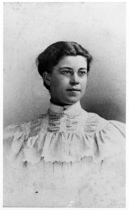
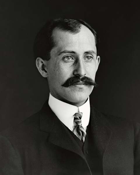
Oakwood began in 1804 as Colonel Robert Patterson's farm south of Dayton on high ground above the Great Miami River, was platted as a residential settlement of 94 lots in 1872 by Isaac Haas, Patterson Mitchell, William Dixon and Gabriel Harman, and grew slowly until National Cash Register founder John H. Patterson and the electrified streetcar drew Dayton commuters up the hill in the 1880s and 1890s. It incorporated as a village in 1908 with 67 homes, then boomed after the 1913 Dayton Flood as developers advertised its ground '275 feet higher than the intersection of Third and Main Streets,' becoming a city in 1931. It is best known today as the town where Orville Wright, his sister Katharine, and their father Bishop Milton Wright lived from 1914 at their estate Hawthorn Hill.
Settled 1804, platted 1872, incorporated 1908, by Isaac Haas, Patterson Mitchell, William Dixon and Gabriel Harman platted the settlement in 1872.
Where the name comes from
No known source we consulted gives a documented explanation of why the platted settlement was named Oakwood; the Oakwood Historical Society's own history does not address it.
Before the town
No Native American village, trail, mound or treaty site specific to Oakwood's own ground is documented in the sources checked. Oakwood sits on high ground above the Great Miami River just south of the site where Dayton's founding Thompson Party in 1796 found 'two small camps of Native Americans' near the river landing; the broader Great Miami valley was Shawnee and Miami (Myaamia) country, part of the land pushed west of the 1795 Treaty of Greenville boundary line.
Nations recorded here: Shawnee, Miami.
Timeline
- — Colonel Robert Patterson acquires land along the Great Miami River south of Dayton, on ground later part of Oakwood.
- — Ten taxpayers, including settler William Kramer with orchards, vineyards and flower gardens on 60 acres, own property in what is now Oakwood.
- — Isaac Haas, Patterson Mitchell, William Dixon and Gabriel Harman plat the settlement of Oakwood, laying out lots for 94 homes; only a few are built at first.
- — NCR founder John H. Patterson establishes the Sugar Camp training facility and Hills and Dales Park, driving Oakwood's growth as a National Cash Register suburb; the electrified streetcar reaches Five Points in 1895.
- — Oakwood incorporates as a village with 67 homes.
- — The Great Dayton Flood devastates downtown Dayton; real estate advertising afterward touts Oakwood property as '275 feet higher than the intersection of Third and Main Streets,' spurring a wave of building on higher ground.
- — Orville Wright, his sister Katharine, and their father Bishop Milton Wright move into Hawthorn Hill at the corner of Harman and Park Avenues in Oakwood.
- — Oakwood becomes a city.
- — Oakwood adopts a council/manager form of government, still in place.
- — Wright Memorial Public Library opens on Far Hills Avenue, a Tudor Revival building designed by Dayton firm Schenck and Williams.
- — Wright Memorial Library is listed on the National Register of Historic Places.
Stories
The Wrights move up the hill to Hawthorn Hill
In 1914 Orville Wright, his sister Katharine, and their father, Bishop Milton Wright, moved into a new home at Harman and Park Avenues in Oakwood, a brick Classical Revival house designed by the Dayton firm Schenck and Williams with Wilbur and Orville after the family's fame and fortune from the Flyer had grown beyond what the old Hawthorn Street house on Dayton's west side could hold. The Wrights named the estate Hawthorn Hill after the hawthorn trees on the property. He lived there until his death in 1948; the National Cash Register Company owned the house for decades afterward before donating it to the Wright Family Foundation on August 18, 2006. It sits within the same Oakwood that grew up as a hillside retreat from a flood-prone downtown, and remains the town's best-known address.
A quarry family's house becomes a landmark
When Isaac Haas, Patterson Mitchell, William Dixon and Gabriel Harman platted Oakwood in 1872, the west side of their new settlement turned out to be poor ground for farming, and it was worked instead as stone and gravel quarries. One of those quarrying operations was run by the Long and Romspert families, whose house at what is now 1947 Far Hills Avenue survives and is listed on the National Register of Historic Places, a trace of the industry that occupied Oakwood's low ground before the streetcar and the National Cash Register Company turned the hill into a commuter suburb.
Photographs
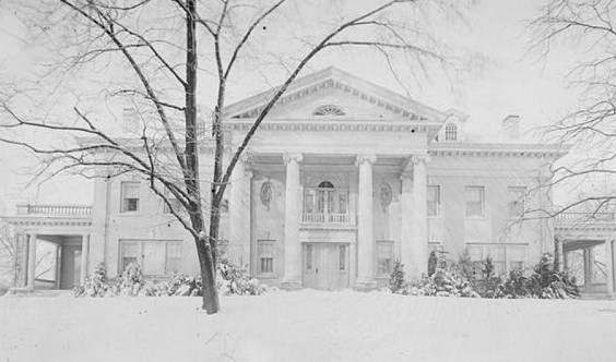
Photo: Papers of Wilbur and Orville Wright, public domain · Wikimedia Commons
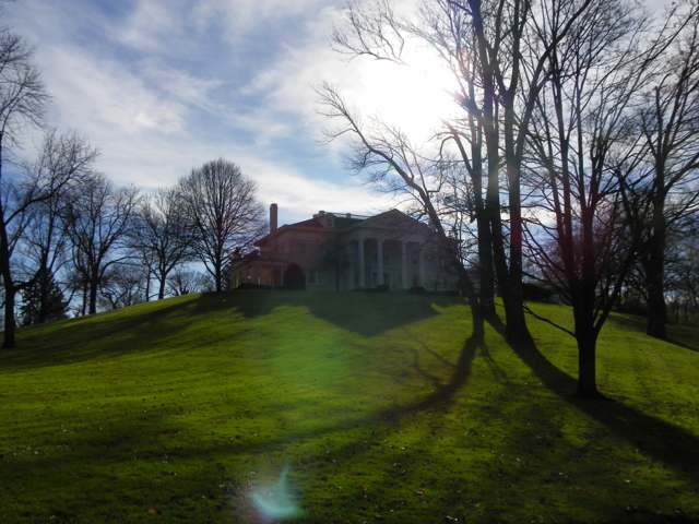
Photo: Zeist85, public domain · Wikimedia Commons
Local history sources: oakwoodhistory.org · en.wikipedia.org · en.wikipedia.org · en.wikipedia.org · daytondailynews.com · en.wikipedia.org · en.wikipedia.org · en.wikipedia.org · commons.wikimedia.org · commons.wikimedia.org
Historic places
4 places in Oakwood on the National Register of Historic Places, 1 of them National Historic Landmark. Press a pin or a name for its whole record.
-
Hawthorn Hill LandmarkBuilding · Oakwood · listed 1974
- Address
- Harman and Park Aves.
- Where
- Oakwood, Montgomery County · ZIP 45419
- What it is
- Building
- Listed on the National Register
- 1974
- National Historic Landmark
- Yes
- NRIS reference number
- 74001585
- Coordinates
- 39.72236, -84.17616
National Register file (NPS) ↗ Search Wikipedia ↗ Street map and directions ↗ On the Cracked Buckeye map
-
Long--Romspert HouseBuilding · Oakwood · listed 1987
- Address
- 1947 Far Hills Ave.
- Where
- Oakwood, Montgomery County · ZIP 45419
- What it is
- Building
- Listed on the National Register
- 1987
- NRIS reference number
- 87001522
- Coordinates
- 39.71398, -84.17224
National Register file (NPS) ↗ Search Wikipedia ↗ Street map and directions ↗ On the Cracked Buckeye map
-
Schantz, Adam Sr., HouseBuilding · Oakton · listed 1980
- Address
- 314-316 Schantz Ave.
- Where
- Oakton, Montgomery County · ZIP 45409
- What it is
- Building
- Listed on the National Register
- 1980
- NRIS reference number
- 80003178
- Coordinates
- 39.73192, -84.17641
National Register file (NPS) ↗ Search Wikipedia ↗ Street map and directions ↗ On the Cracked Buckeye map
-
Wright LibraryBuilding · Dayton · listed 2013
- Address
- 1776 Far Hills Ave.
- Where
- Dayton, Montgomery County · ZIP 45419
- What it is
- Building
- Listed on the National Register
- 2013
- NRIS reference number
- 13000981
- Coordinates
- 39.71558, -84.17124
National Register file (NPS) ↗ Search Wikipedia ↗ Street map and directions ↗ On the Cracked Buckeye map
Source: National Park Service, National Register of Historic Places point file. The listing year is shown where NPS's certification date agrees with the listing's reference number. Listing recognizes significance; it does not restrict a private owner.
Water
Groundwater from 8 municipal production wells scattered across Oakwood's small (about 2.2 sq mi) wellfield, feeding the shared Great Miami Buried Valley Aquifer system The water here
- Montgomery County Water Services 136% of residentsGreat Miami Buried Valley Aquifer wells (recharged by Great Miami & Mad Rivers)
- Oakwood City35% of residentsGreat Miami Buried Valley Aquifer (wells)
- Dayton Public Water System29% of residentsGreat Miami Buried Valley Aquifer wells (recharged by Great Miami & Mad Rivers)
Hospitals, fire stations and more
Inside Oakwood's boundary: 1 fire or EMS station, 4 public schools, 1 private school, 1 library, 1 museum, 3 public charging sites and 1 spill case. Press a pin or a name for its whole record and its source.
Fire and EMS stations (1)
-
Oakwood Safety DepartmentDayton
- Address
- 30 Park Avenue, Dayton, OH 45419
- Coordinates
- 39.72284, -84.17445
USGS National Map structures (source) ↗ Street map and directions ↗
Source: USGS National Map structures (most Ohio records last updated 2019 to 2022), checked against the Columbus and Cleveland station lists. The department that answers a call is set by jurisdiction and mutual aid, not by distance.
Public schools (4)
-
Harman Elementary School4.5 of 5 stars · Dayton
- Address
- 735 Harman Ave, Dayton, OH 45419
- School district
- Oakwood City School District
- Kind (NCES)
- Regular School
- Students, 2023-24
- 428
- Teachers (full-time equivalent)
- 27
- Report card, 2025-26
- 4.5 of 5 stars
- Performance index
- 96.9%
- Ohio building IRN
- 015289
- NCES school ID
- 390445801466
NCES school record ↗ Ohio School Report Card ↗ Street map and directions ↗
-
Oakwood High School5 of 5 stars · Dayton
- Address
- 1200 Far Hills Ave, Dayton, OH 45419
- School district
- Oakwood City School District
- Kind (NCES)
- Regular School
- Students, 2023-24
- 668
- Teachers (full-time equivalent)
- 35.14
- Report card, 2025-26
- 5 of 5 stars
- Performance index
- 99.9%
- Four-year graduation rate
- 98.8%
- Ohio building IRN
- 028373
- NCES school ID
- 390445801467
NCES school record ↗ Ohio School Report Card ↗ Street map and directions ↗
-
Oakwood Junior High School5 of 5 stars · Dayton
- Address
- 1200 Far Hills Ave, Dayton, OH 45419
- School district
- Oakwood City School District
- Kind (NCES)
- Regular School
- Students, 2023-24
- 305
- Teachers (full-time equivalent)
- 26.01
- Report card, 2025-26
- 5 of 5 stars
- Performance index
- 97.8%
- Ohio building IRN
- 093195
- NCES school ID
- 390445804264
NCES school record ↗ Ohio School Report Card ↗ Street map and directions ↗
-
Smith Elementary School5 of 5 stars · Dayton
- Address
- 1701 Shafor Blvd, Dayton, OH 45419
- School district
- Oakwood City School District
- Kind (NCES)
- Regular School
- Students, 2023-24
- 514
- Teachers (full-time equivalent)
- 31.52
- Report card, 2025-26
- 5 of 5 stars
- Performance index
- 97.7%
- Ohio building IRN
- 034694
- NCES school ID
- 390445801469
NCES school record ↗ Ohio School Report Card ↗ Street map and directions ↗
Source: NCES EDGE public school locations 2024-25 and Common Core of Data 2023-24 (type, students, teachers); Ohio School Report Cards 2025-26 (Department of Education and Workforce), matched by name within the district.
Private schools (1)
-
Hillel Academy of Greater DaytonPrivate, religious, denomination-affiliated · Dayton
- Address
- 305 Sugar Camp Cir, Dayton, OH 45409
- Kind
- religious, denomination-affiliated
- Students, 2023-24
- 32
- Teachers (full-time equivalent)
- 7.1
- Students per teacher
- 4.50704
- Phone
- (937) 277-8966
- NCES private school ID
- 01063809
Source: NCES Private School Survey 2023-24.
Public libraries (1)
-
Wright Memorial Public LibraryCentral library · Oakwood
- Address
- 1776 Far Hills Ave., Oakwood, OH 45419
- What it is
- Central library
- Library system
- Wright Memorial Public Library
- Open
- 3,432 hours a year, 52 weeks
- Building
- 24,180 sq ft
- System's visits, FY2024
- 125,112
- System's loans, FY2024
- 364,232
- People the system serves
- 9,547
- Phone
- (937) 294-7171
IMLS Public Libraries Survey (source) ↗ Street map and directions ↗
Source: IMLS Public Libraries Survey FY2024 (outlets and their systems). Any Ohio resident can get a free card at any Ohio public library.
Museums, historical societies, gardens and zoos (1)
-
Oakwood Historical SocietyHistorical society · Dayton
- What it is
- Historical society
- City
- Dayton
- Coordinates
- 39.71420, -84.17180
Search Wikipedia ↗ IMLS Museum Data Files (source) ↗ Street map and directions ↗
The museum list is IMLS's 2018 file; a museum may have closed or moved since.
Source: IMLS Museum Data Files, 2018.
Public EV charging (3)
-
Dorothy Lane Market Oakwood - Tesla Destination2 Level 2 · Dayton
- Address
- 2710 Far Hills Ave, Dayton, OH 45419
- Ports
- 2 Level 2
- Plugs
- J1772, Tesla (NACS)
- Network
- Tesla Destination
- Phone
- 877-798-3752
Station Locator (NREL) ↗ Alternative Fuels Data Center (source) ↗ Street map and directions ↗
-
Element Oakwood4 Level 2 · Dayton
- Address
- 310 Old River Trail, Dayton, OH 45409
- Ports
- 4 Level 2
- Plugs
- J1772
- Network
- FLO
- Hours
- 24 hours daily
- Phone
- 888-356-8911
Station Locator (NREL) ↗ Alternative Fuels Data Center (source) ↗ Street map and directions ↗
-
ORCHARD DR ORCHARD LOT2 Level 2 · Dayton
- Address
- 22 Orchard Dr, Dayton, OH 45419
- Ports
- 2 Level 2
- Plugs
- J1772
- Network
- ChargePoint Network
- Hours
- 24 hours daily
- Phone
- 888-758-4389
Station Locator (NREL) ↗ Alternative Fuels Data Center (source) ↗ Street map and directions ↗
Source: NREL Alternative Fuels Data Center station list (May 2026), public and open stations, the posts at one address counted as one site.
Spills reported since 2021 (1)
-
Material Blue2025-08-28 · Oakwood
- Reported
- 2025-08-28
- What spilled
- Material Blue
- Where
- Oakwood, Montgomery County
- Ohio EPA district office
- SWDO
- Ohio EPA case number
- 2508EPA0001462
Ohio EPA spill reports (source) ↗ Street map and directions ↗
Source: Ohio EPA emergency response spill reports, 2021 to September 2026, one point per case where Ohio EPA placed it. A report is what the caller or responder recorded; amounts are often blank or estimated.
Its ZIP codes
Each ZIP code that touches Oakwood, with the share of its residents who live here and the same headline figures as the ZIP page.
Local government
Who holds office in Oakwood, how its elections and ballot issues came out, and the state auditor's record.
Elections for office
| Date | Office | Candidates and votes |
|---|---|---|
| 2025-11-04 | Council Member (unofficial count) | Sam Dorf 1,814, 34.2%; Sarena Kelley 1,588, 29.94%; Leigh S. Turben 1,902, 35.86% |
Winners in bold. Results from the county board of elections' official canvass unless marked.
Auditor of State record
- No fiscal caution, watch or emergency on the Auditor of State's lists.
- Financial Health Indicators (the Auditor of State's 17 measures; critical / cautionary / positive): 2020 0 / 1 / 16; 2021 0 / 1 / 16; 2022 0 / 1 / 16; 2023 0 / 2 / 15; 2024 1 / 1 / 15; 2025 0 / 3 / 13.
- OP&F Examination, 2024, released 2026-05-14
- Financial Audit, 2024, released 2026-01-06
The county
Montgomery County: 33 ZIP codes, 27 cities, villages and townships, 531,614 people.
Nearby places
Rain and snow
How much has actually fallen on Oakwood, day by day, from 1893 to now. Daily totals, not averages.
- rain, last 30 days
- 0.89 in
- 2026-09-29 to 2026-10-28
- rain so far in 2026
- 50.7 in
- 13.2 in above normal for the date
- snow so far in 2026
- 18.0 in
- a normal year brings 15.6 in
- a normal year
- 44.3 in
- average of 30 years, 1991-2020
| Month | Rain (in) | Snow (in) | Days counted |
|---|---|---|---|
| October 2026 | 0.89 | — | 28 |
| September 2026 | 6.72 | — | 30 |
| August 2026 | 11.78 | — | 31 |
| July 2026 | 3.47 | — | 31 |
| June 2026 | 3.33 | — | 30 |
| May 2026 | 9.07 | — | 31 |
| April 2026 | 4.12 | — | 30 |
| March 2026 | 6.96 | 0.4 | 31 |
| February 2026 | 2.72 | 3.5 | 28 |
| January 2026 | 1.63 | 14.1 | 31 |
| December 2025 | 2.12 | 8.6 | 31 |
| November 2025 | 2.45 | 3.8 | 30 |
| Wettest year | 2011 — 65.5 in |
|---|---|
| Driest year | 1934 — 23.7 in |
| Snowiest year | 1978 — 39.7 in |
| Wettest day on record | 14 September 1979 — 4.69 in |
| Heaviest snowfall in a day | 6 January 2025 — 11.30 in |
| Deepest snow on the ground | 27 January 1978 — 18.94 in |
Mostly estimated. Only 6% of these days come from a gauge standing inside Oakwood - the rest are worked out from the nearest gauges around it, so read them as close estimates rather than readings.
48,192 days of records, 1893-06-02 to 2026-10-28. Source: NOAA NCEI GHCN-Daily, 3,240 gauges in and around Ohio. A day is "gauged" when a gauge standing inside the boundary reported it, and the value is the mean of those gauges. Otherwise it is interpolated by inverse distance from every gauge reporting within 50 miles. Nothing is carried forward, back-filled or smoothed. Against NOAA nClimDiv county monthly precipitation over 136,848 complete county-months (checked 2026-10-31): correlation 0.9515, median absolute difference 0.217 in a month. Built 2026-10-31 from the Cracked Buckeye precipitation archive. Snow is the softer number — snowfall is measured by hand with a ruler, no agency publishes a gridded county snowfall series, and blowing snow defeats every observer.
Environmental permits and filings
What Ohio EPA has on file for Oakwood: permits, inspections, violations, cleanups and the state loans behind sewer and water work. Every line links to the agency's own document.
- facilities and sites on file
- 1
- those placed on the map inside Oakwood
| Program | Facilities and sites |
|---|---|
| Wastewater and stormwater discharge | 1 |
| Date | Facility or site | What |
|---|---|---|
| RUNNYMEDE HILLS | Wastewater and stormwater discharge permit |
Source: Ohio EPA eDocument portal (edocpub.epa.ohio.gov), indexed 2026-10-14. Facilities are placed on the map from Ohio EPA's own map layers, EPA's Facility Registry, coordinates written in the filings, or a geocoded street address. A permit filed under a private person's name (most are household septic systems) is counted but never named, placed or linked; licenses for individual workers and open-burning notices are left out entirely.
Quick answers
What county is Oakwood, Ohio in?
Oakwood is a city in Montgomery County, Ohio, with 9,565 residents.
When was Oakwood, Ohio founded?
Oakwood was settled 1804; laid out 1872; incorporated 1908. Founders on record: Isaac Haas, Patterson Mitchell, William Dixon and Gabriel Harman platted the settlement in 1872. Source
How did Oakwood, Ohio get its name?
No known source we consulted gives a documented explanation of why the platted settlement was named Oakwood; the Oakwood Historical Society's own history does not address it.
What ZIP code is Oakwood, Ohio?
Oakwood is served by ZIP codes 45419 and 45409; 45419 holds the largest share of its residents.
Where does Oakwood, Ohio get its water?
The main water source for Oakwood (Montgomery County Water Services 1): Groundwater from 8 municipal production wells scattered across Oakwood's small (about 2.2 sq mi) wellfield, feeding the shared Great Miami Buried Valley Aquifer system.
Cite this page
Cite this page as:
Cracked Buckeye, "Oakwood, Montgomery County", https://crackedbuckeye.com/place/oakwood/, built 2026-10-31, accessed [date].
How to cite · Report a correction · Built 2026-10-31
