Local events in Norwood
34 events in the next 90 days from 4 public calendars. All local events in Norwood
Checked October 20; the events page is refreshed daily.
How Norwood began
Pioneer Peter Smith is believed to have settled on Duck Creek around 1794, and by 1809 Samuel D. Bowman's tavern and coach stop and John Sharp's country store had built up a community known as Sharpsburg. In 1869 developers platted a new subdivision on the site and, by most accounts at landowner Lemuel Bolles's wife Sarah's suggestion, named it Norwood; the post office and the town's own name followed in 1870. Norwood incorporated as a village in 1888 and a city in 1902, industrialized into what one 1909 account called the "Chicago" of Hamilton County, and from 1923 to 1987 hosted a General Motors assembly plant that at its 1970s peak employed nearly 9,000 workers and supplied a third of the city's operating budget. Norwood is today a small, dense independent city entirely surrounded by Cincinnati, still built around Water Tower Park, whose Adena-culture Norwood Mound an 1895 source called "the only Indian mound now remaining in the vicinity of Cincinnati."
Settled c. 1794 (Peter Smith, on Duck Creek); community known as Sharpsburg by 1809, platted 1869 (subdivision platted, renamed Norwood), incorporated village, May 14, 1888; city, 1902, by developers who platted the 1869 subdivision; name credited to Sarah Bolles.
Where the name comes from
The community was known as Sharpsburg, after storekeeper John Sharp, until an 1869 subdivision plat introduced the name Norwood, credited to Sarah Bolles, wife of landowner Lemuel Bolles. Sources give competing explanations for her choice: an abbreviation of "Northwood" for the wooded land north of Cincinnati, an echo of Henry Ward Beecher's 1869 novel "Norwood: or, Village Life in New England," or simply a blend of "North" and "Woods." The Cincinnati Enquirer reported in 1870 that "the old town of Sharpsburg has been changed to Norwood," the same year the post office was renamed.
Before the town
Norwood holds the Norwood Mound, an elliptical Adena-culture earthwork roughly 100 by 130 feet across and 15.5 feet high, built on what is now the highest ground in the city, 811 feet in elevation, inside Water Tower Park. There is no evidence the mound has ever been excavated. Early Norwood settlers collected relics from the surrounding area in the late 1800s that became the founding core of the Cincinnati Art Museum's Native American art collection, and in 1875 Norwood settler S. H. Parvin deeded the mound site itself to the village. An 1895 source called it the only Indian mound then remaining in the vicinity of Cincinnati; archaeologists believe it was used for religious ceremonies and possibly for signal fires, given its commanding elevation. It was listed on the National Register of Historic Places on May 2, 1974.
Nations recorded here: Adena culture.
- Norwood Mound (mound) — Water Tower Park, Norwood, at 811 feet elevation, the highest ground in the city, Adena culture (roughly 800 BC - AD 100) (en.wikipedia.org)
Timeline
- — Peter Smith is believed to settle on Duck Creek, one of the area's earliest residents.
- — Samuel D. Bowman opens a tavern and coach stop and John Sharp opens a country store, forming the community that becomes known as Sharpsburg.
- — Developers plat a subdivision on the site and rename it Norwood, credited to Sarah Bolles, wife of landowner Lemuel Bolles.
- — The Cincinnati Enquirer reports the old town of Sharpsburg has officially changed its name to Norwood, and the post office is renamed the same year.
- — Norwood settler S. H. Parvin deeds the Norwood Mound site to the Village of Norwood.
- — Norwood incorporates as a village on May 14.
- — Norwood becomes a city.
- — Norwood has 49 manufacturing enterprises, earning it description as the "Chicago" of Hamilton County.
- — Population reaches 16,185, a 150 percent jump from 1900 as industrialization and rail access draw workers.
- — General Motors opens its Norwood Assembly plant, a 3,000,000-square-foot facility on 50 acres purchased the year before.
- — City population peaks at 33,411.
- — The Norwood Mound is listed on the National Register of Historic Places on May 2.
- — GM announces the Norwood plant's closure on November 6, 1986, citing its landlocked, hard-to-modernize campus, and closes it in 1987, eliminating a third of the city's operating budget and about 1,000 resident jobs among 4,300 total.
- — The Ohio Supreme Court rules unanimously for homeowners in City of Norwood v. Horney, striking down the city's attempt to seize about 70 homes and businesses for private redevelopment and voiding a state eminent-domain statute as unconstitutionally vague.
Stories
The eminent-domain case that changed Ohio law
After General Motors closed its Norwood plant in 1987, the city spent nearly two decades looking for something to replace the tax base it had lost. In the early 2000s Norwood set its sights on a different neighborhood entirely, moving to condemn roughly 70 homes and businesses along Edwards Road to clear the way for a private retail, office, and condominium development. Homeowners Joe Horney, Carl and Joy Gamble, and Matthew and Sanae Burton refused to sell and sued, represented by the property-rights group the Institute for Justice, arguing the city had no right to take their homes just to hand the land to a different private owner who might pay more in taxes. The case reached the Ohio Supreme Court as City of Norwood v. Horney, and on July 26, 2006, the court ruled unanimously for the homeowners, holding that economic benefit alone could never justify eminent domain under the Ohio Constitution and striking down the state law that let cities condemn merely "deteriorating" areas as unconstitutionally vague. Coming a year after the U.S. Supreme Court's Kelo v. City of New London had gone the other way under federal law, Norwood v. Horney became one of the strongest state-level property-rights rulings in the country, and Norwood's own name now marks the case in law school casebooks nationwide.
The only mound left in Cincinnati's shadow
By 1895, an observer could already write that the earthen mound atop what is now Water Tower Park was "the only Indian mound now remaining in the vicinity of Cincinnati" -- every other one nearby had already been leveled by farming, quarrying, or the city's own growth. The Norwood Mound had survived because of its location: at 811 feet, it sits on the highest ground in what became Norwood, land not particularly good for building or farming but ideal, archaeologists believe, for the religious ceremonies and long-distance signal fires the Adena culture may have used it for a thousand years before Rome fell. Early Norwood settlers combing the surrounding fields for arrowheads and pottery in the late 1800s built a relic collection substantial enough to become the founding nucleus of the Cincinnati Art Museum's Native American art collection, while the mound itself passed into public hands in 1875, when settler S. H. Parvin deeded the site to the village. It has never been excavated, and it still stands, unopened, in a city park surrounded on every side by one of Ohio's largest cities.
Photographs
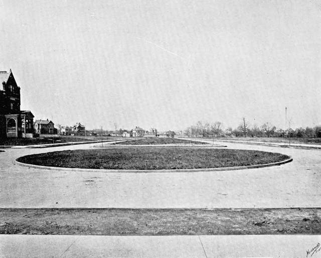
Photo: Ren Mulford Jr. and Werter G. Betty, "Norwood, Her Homes And Her People", public domain · Wikimedia Commons
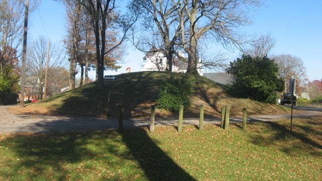
Photo: Nyttend, public domain · Wikimedia Commons
Local history sources: en.wikipedia.org · en.wikipedia.org · en.wikipedia.org · commons.wikimedia.org · commons.wikimedia.org
Historic places
2 places in Norwood on the National Register of Historic Places. Press a pin or a name for its whole record.
-
Cincinnati Street Gas LampsHistoric district · Cincinnati · listed 1978
- Address
- 1109 Street lamps at various locations throughout Cincinnati
- Where
- Cincinnati, Hamilton County · ZIP 45212
- What it is
- Historic district
- Listed on the National Register
- 1978
- NRIS reference number
- 78002073
- Coordinates
- 39.15447, -84.46041
National Register file (NPS) ↗ Search Wikipedia ↗ Street map and directions ↗ On the Cracked Buckeye map
-
Norwood Municipal BuildingBuilding · Norwood · listed 1980
- Address
- 4645 Montgomery Rd.
- Where
- Norwood, Hamilton County · ZIP 45212
- What it is
- Building
- Listed on the National Register
- 1980
- NRIS reference number
- 80003093
- Coordinates
- 39.16172, -84.45615
National Register file (NPS) ↗ Search Wikipedia ↗ Street map and directions ↗ On the Cracked Buckeye map
Source: National Park Service, National Register of Historic Places point file. The listing year is shown where NPS's certification date agrees with the listing's reference number. Listing recognizes significance; it does not restrict a private owner.
Water
Ohio River intake at the plant's riverfront on Kellogg Ave in the California neighborhood, east Cincinnati The water here
- Norwood City85% of residentsOhio River (Miller Plant, ~88%) plus Great Miami Buried Valley Aquifer wells (~12%)
- Cincinnati Public Water System15% of residentsOhio River (Miller Plant, ~88%) plus Great Miami Buried Valley Aquifer wells (~12%)
Hospitals, fire stations and more
Inside Norwood's boundary: 1 hospital, 2 dialysis centers, 1 nursing home, 1 fire or EMS station, 1 college, 7 public schools, 2 private schools, 2 poor-rated bridges, 1 library, 1 museum, 1 police station, 5 public charging sites, 3 Superfund sites, 13 Toxics Release Inventory facilities, 6 spill cases and 1 mound or earthwork. Press a pin or a name for its whole record and its source.
Hospitals (1)
-
Encompass Hlth. Rehab. Hsptl. of Cin. at NorwoodRehabilitation hospital · Cincinnati
- What it is
- Rehabilitation hospital
- Address
- 4953 Section Avenue, Cincinnati, OH 45212
- County
- Hamilton County
- Beds
- 40
- Ownership
- Proprietary
- Phone
- (513) 712-9200
Where HIFLD got this record ↗ HIFLD hospitals (source) ↗ Street map and directions ↗
Source: HIFLD hospitals inventory via FEMA (closed hospitals it still lists left out, hospitals opened since added), with Medicare Care Compare ratings matched by name and address.
Dialysis centers (2)
-
Davita Norwood DialysisDialysis · Cincinnati
- Address
- 2300 Wall Street, Cincinnati, OH 45212
- Dialysis stations
- 25
- Medicare star rating
- 3 of 5 stars
- Services
- in-center hemodialysis
- Ownership
- for profit
- Chain
- DaVita
- Medicare certified since
- 2009-08-26
- Phone
- (513) 531-2111
- Medicare ID
- 362742
Medicare Care Compare ↗ CMS dialysis facility list (source) ↗ Street map and directions ↗
-
Fmc - Liberty NorwoodDialysis · Norwood
- Address
- 2071 Sherman Avenue, Norwood, OH 45212
- Dialysis stations
- 24
- Medicare star rating
- 2 of 5 stars
- Services
- in-center hemodialysis, peritoneal dialysis, home hemodialysis training
- Ownership
- for profit
- Chain
- Fresenius Medical Care
- Medicare certified since
- 2009-11-19
- Phone
- (513) 841-1800
- Medicare ID
- 362747
Medicare Care Compare ↗ CMS dialysis facility list (source) ↗ Street map and directions ↗
Source: CMS dialysis facility list, September 2026, geocoded with the Census Bureau batch geocoder (an address it could not place sits at its ZIP center).
Nursing homes (1)
-
Norwood Towers Post-Acute2 of 5 stars · Cincinnati
- Address
- 1500 Sherman Avenue, Cincinnati, OH 45212
- Certified beds
- 120
- Residents on an average day
- 103
- Medicare overall rating
- 2 of 5 stars
- Health inspections
- 1 of 5 stars
- Staffing
- 1 of 5 stars
- Quality measures
- 5 of 5 stars
- Penalties since 2023
- 1 payment denial (latest 2025-12-16)
- Ownership
- For profit - Limited Liability company
- Chain
- PACS GROUP
- Takes
- Medicare and Medicaid
- Phone
- (513) 631-6800
- Medicare ID
- 366238
Medicare Care Compare ↗ CMS nursing home data (source) ↗ Street map and directions ↗
Source: CMS Care Compare nursing home provider and penalties files; Medicare star ratings run 1 to 5.
Fire and EMS stations (1)
-
Norwood Fire DepartmentNorwood
- Address
- 4725 Montgomery Road, Norwood, OH 45212
- Coordinates
- 39.16252, -84.45579
USGS National Map structures (source) ↗ Street map and directions ↗
Source: USGS National Map structures (most Ohio records last updated 2019 to 2022), checked against the Columbus and Cleveland station lists. The department that answers a call is set by jurisdiction and mutual aid, not by distance.
Colleges (1)
-
Ohio Media School-CincinnatiFor-profit career school · Norwood
- What it is
- For-profit career school
- City
- Norwood
- Students, 2023-24 (12-month count)
- 230
- IPEDS unit ID
- 418269
College Navigator (NCES) ↗ IPEDS data (source) ↗ Street map and directions ↗
Source: NCES IPEDS 2024 directory, 2023-24 enrollment and tuition, graduation rates for the 2017 (four-year) and 2020 (two-year) entering classes.
Public schools (7)
-
ChallengeU Ohio Community SchoolCincinnati
- Address
- 4030 Smith Rd Ste 200, Cincinnati, OH 45209
- Kind (NCES)
- Regular School
- Students, 2023-24
- 64
- Teachers (full-time equivalent)
- 1
- NCES school ID
- 391004810866
-
Norwood High School3.5 of 5 stars · Norwood
- Address
- 2020 Sherman Ave, Norwood, OH 45212
- School district
- Norwood City School District
- Kind (NCES)
- Regular School
- Students, 2023-24
- 448
- Teachers (full-time equivalent)
- 32.28
- Report card, 2025-26
- 3.5 of 5 stars
- Performance index
- 72.1%
- Four-year graduation rate
- 86.1%
- Ohio building IRN
- 028100
- NCES school ID
- 390445701461
NCES school record ↗ Ohio School Report Card ↗ Street map and directions ↗
-
Norwood Middle School3.5 of 5 stars · Norwood
- Address
- 2060 Sherman Ave, Norwood, OH 45212
- School district
- Norwood City School District
- Kind (NCES)
- Regular School
- Students, 2023-24
- 374
- Teachers (full-time equivalent)
- 27
- Report card, 2025-26
- 3.5 of 5 stars
- Performance index
- 67.6%
- Ohio building IRN
- 064857
- NCES school ID
- 390445701462
NCES school record ↗ Ohio School Report Card ↗ Street map and directions ↗
-
Norwood View Elementary School3 of 5 stars · Norwood
- Address
- 5328 Carthage Ave, Norwood, OH 45212
- School district
- Norwood City School District
- Kind (NCES)
- Regular School
- Students, 2023-24
- 264
- Teachers (full-time equivalent)
- 19.81
- Report card, 2025-26
- 3 of 5 stars
- Performance index
- 74.1%
- Ohio building IRN
- 028118
- NCES school ID
- 390445701463
NCES school record ↗ Ohio School Report Card ↗ Street map and directions ↗
-
Sharpsburg Elementary3 of 5 stars · Norwood
- Address
- 4400 Smith Rd, Norwood, OH 45212
- School district
- Norwood City School District
- Kind (NCES)
- Regular School
- Students, 2023-24
- 258
- Teachers (full-time equivalent)
- 16.48
- Report card, 2025-26
- 3 of 5 stars
- Performance index
- 76.1%
- Ohio building IRN
- 000471
- NCES school ID
- 390445701459
NCES school record ↗ Ohio School Report Card ↗ Street map and directions ↗
-
The Norwood Montessori School3.5 of 5 stars · Norwood
- Address
- 2060 Sherman Ave, Norwood, OH 45212
- School district
- Norwood City School District
- Kind (NCES)
- Regular School
- Students, 2023-24
- 93
- Teachers (full-time equivalent)
- 4.94
- Report card, 2025-26
- 3.5 of 5 stars
- Performance index
- 71.3%
- Ohio building IRN
- 019994
- NCES school ID
- 390445710846
NCES school record ↗ Ohio School Report Card ↗ Street map and directions ↗
-
Williams Avenue Elementary School4 of 5 stars · Norwood
- Address
- 2132 Williams Ave, Norwood, OH 45212
- School district
- Norwood City School District
- Kind (NCES)
- Regular School
- Students, 2023-24
- 243
- Teachers (full-time equivalent)
- 16.14
- Report card, 2025-26
- 4 of 5 stars
- Performance index
- 75.6%
- Ohio building IRN
- 041418
- NCES school ID
- 390445701465
NCES school record ↗ Ohio School Report Card ↗ Street map and directions ↗
Source: NCES EDGE public school locations 2024-25 and Common Core of Data 2023-24 (type, students, teachers); Ohio School Report Cards 2025-26 (Department of Education and Workforce), matched by name within the district.
Private schools (2)
-
Azalea Montessori SchoolPrivate, nonsectarian, special program · Cincinnati
- Address
- 4305 Floral Ave, Cincinnati, OH 45212
- Kind
- nonsectarian, special program
- Students, 2023-24
- 56
- Teachers (full-time equivalent)
- 7
- Students per teacher
- 8
- Phone
- (513) 476-9344
- NCES private school ID
- A2301896
-
Immaculate Conception AcademyPrivate, Catholic · Cincinnati
- Address
- 4510 Floral Ave, Cincinnati, OH 45212
- Kind
- Catholic
- Students, 2023-24
- 112
- Teachers (full-time equivalent)
- 16.6
- Students per teacher
- 6.74699
- Phone
- (513) 731-0154
- NCES private school ID
- BB170297
Source: NCES Private School Survey 2023-24.
Bridges rated poor (2)
-
Harris Avenue over Duck CreekPoor · built 1900
- Condition
- Poor: a deck, superstructure, substructure or culvert rated 4 or below on the 0 to 9 scale
- What it is
- Bridge
- Built
- 1900
- Length
- 12 ft
- Owner
- City
- Vehicles a day
- 200
- Coordinates
- 39.16165, -84.43787
National Bridge Inventory (source) ↗ Street map and directions ↗
-
Wesley Ave over SR 562Poor · built 1970
- Condition
- Poor: a deck, superstructure, substructure or culvert rated 4 or below on the 0 to 9 scale
- What it is
- Bridge
- Built
- 1970
- Length
- 54 ft
- Owner
- State
- Vehicles a day
- 1,949
- Coordinates
- 39.16397, -84.45135
National Bridge Inventory (source) ↗ Street map and directions ↗
Source: FHWA National Bridge Inventory 2025. "Poor" means one major part rated 4 or below on the 0 to 9 scale; it calls for repair, not closing, unless the state posts or closes the bridge.
Public libraries (1)
-
NorwoodBranch · Norwood
- Address
- 4325 Montgomery Rd., Norwood, OH 45212
- What it is
- Branch
- Library system
- Cincinnati and Hamilton County Public Library
- Open
- 2,808 hours a year, 52 weeks
- Building
- 12,570 sq ft
- System's visits, FY2024
- 4,091,256
- System's loans, FY2024
- 20,126,186
- People the system serves
- 830,639
- Phone
- (513) 369-6037
IMLS Public Libraries Survey (source) ↗ Street map and directions ↗
Source: IMLS Public Libraries Survey FY2024 (outlets and their systems). Any Ohio resident can get a free card at any Ohio public library.
Museums, historical societies, gardens and zoos (1)
-
Norwood Historical SocietyHistorical society · Norwood
- What it is
- Historical society
- City
- Norwood
- Coordinates
- 39.15596, -84.45200
Search Wikipedia ↗ IMLS Museum Data Files (source) ↗ Street map and directions ↗
The museum list is IMLS's 2018 file; a museum may have closed or moved since.
Source: IMLS Museum Data Files, 2018.
Police stations (1)
-
Norwood Police DepartmentNorwood
- Address
- 4701 Montgomery Road, Norwood, OH 45212
- Coordinates
- 39.16212, -84.45579
USGS National Map structures (source) ↗ Street map and directions ↗
Source: USGS National Map structures, police stations, corrected and completed by hand (September 2026). The department that answers a call is set by jurisdiction, not by distance.
Public EV charging (5)
-
CORNERSTONE STATION12 Level 2 · Cincinnati
- Address
- 4000 Smith Rd, Cincinnati, OH 45209
- Ports
- 2 Level 2
- Plugs
- J1772
- Network
- ChargePoint Network
- Hours
- 24 hours daily
- Phone
- 888-758-4389
Station Locator (NREL) ↗ Alternative Fuels Data Center (source) ↗ Street map and directions ↗
-
CORNERSTONE STATION22 Level 2 · Cincinnati
- Address
- 4030 Smith Rd, Cincinnati, OH 45209
- Ports
- 2 Level 2
- Plugs
- J1772
- Network
- ChargePoint Network
- Hours
- 24 hours daily
- Phone
- 888-758-4389
Station Locator (NREL) ↗ Alternative Fuels Data Center (source) ↗ Street map and directions ↗
-
ROOKWOOD TOWER STATION32 Level 2 · Cincinnati
- Address
- 3805 Edwards Rd, Cincinnati, OH 45208
- Ports
- 2 Level 2
- Plugs
- J1772
- Network
- ChargePoint Network
- Hours
- 24 hours daily
- Phone
- 888-758-4389
Station Locator (NREL) ↗ Alternative Fuels Data Center (source) ↗ Street map and directions ↗
-
Sherman Ave & Station Ave Parking Lot2 Level 2 · Norwood
- Address
- 2087 Sherman Ave, Norwood, OH 45212
- Ports
- 2 Level 2
- Plugs
- J1772
- Network
- AMPUP
- Hours
- 24 hours daily
- Phone
- 833-692-6787
Station Locator (NREL) ↗ Alternative Fuels Data Center (source) ↗ Street map and directions ↗
-
XAVIER COHEN2 Level 2 · Norwood, Ohio 45212
- Address
- 1658 Herald Ave, Norwood, Ohio 45212, OH 45212
- Ports
- 2 Level 2
- Plugs
- J1772
- Network
- ChargePoint Network
- Hours
- 24 hours daily
- Phone
- 888-758-4389
Station Locator (NREL) ↗ Alternative Fuels Data Center (source) ↗ Street map and directions ↗
Source: NREL Alternative Fuels Data Center station list (May 2026), public and open stations, the posts at one address counted as one site.
Superfund sites (3)
-
Norwood Radiator SiteSuperfund program · Norwood
- Address
- 5111 Globe Avenue, Norwood, OH 45212
- County
- Hamilton County
- Status
- Superfund program site, not on the National Priorities List
- EPA program ID
- OHN000508138
- EPA registry ID
- 110004663383
EPA facility record ↗ EPA Facility Registry Service (source) ↗ Street map and directions ↗
-
Perry & Derrick Paint SiteSuperfund program · Norwood
- Address
- 2511 Highland Avenue, Norwood, OH 45212
- County
- Hamilton County
- Status
- Superfund program site, not on the National Priorities List
- EPA program ID
- OHN000510588
- EPA registry ID
- 110043571015
EPA facility record ↗ EPA Facility Registry Service (source) ↗ Street map and directions ↗
-
Rose Exterminator Company WarehouseSuperfund program · Norwood
- Address
- 5421 Carthage Avenue, Norwood, OH 45212
- County
- Hamilton County
- Status
- Superfund program site, not on the National Priorities List
- EPA program ID
- OHN000510327
- EPA registry ID
- 110038761863
EPA facility record ↗ EPA Facility Registry Service (source) ↗ Street map and directions ↗
Source: EPA Facility Registry Service, Superfund (SEMS) and National Priorities List sites. Many program sites were assessed and needed no cleanup.
Facilities reporting toxic releases (13)
-
Cincinnati Varnish CoToxics Release Inventory · Cincinnati
- Address
- 1776 Mentor Ave, Cincinnati, OH 45212
- County
- Hamilton County
- Status
- Reports to the Toxics Release Inventory (active)
- EPA program ID
- 45242THCNC1776M
- EPA registry ID
- 110000849949
EPA facility record ↗ EPA Facility Registry Service (source) ↗ Street map and directions ↗
-
Cpc GroupToxics Release Inventory · Norwood
- Address
- 4726 Smith Road, Norwood, OH 45212
- County
- Hamilton County
- Status
- Reports to the Toxics Release Inventory (closed)
- EPA program ID
- 45212CPCGR4726S
- EPA registry ID
- 110001625117
EPA facility record ↗ EPA Facility Registry Service (source) ↗ Street map and directions ↗
-
J H Day CoToxics Release Inventory · Cincinnati
- Address
- 4932 Beech St., Cincinnati, OH 45212
- County
- Hamilton County
- Status
- Reports to the Toxics Release Inventory (active)
- EPA program ID
- 45212JHDYC4932B
- EPA registry ID
- 110002112990
EPA facility record ↗ EPA Facility Registry Service (source) ↗ Street map and directions ↗
-
Kdm Signs IncToxics Release Inventory · Cincinnati
- Address
- 2501 Norwood Ave, Cincinnati, OH 45212
- County
- Hamilton County
- Status
- Reports to the Toxics Release Inventory (active)
- EPA program ID
- 45212DSGNC2501N
- EPA registry ID
- 110039508725
EPA facility record ↗ EPA Facility Registry Service (source) ↗ Street map and directions ↗
-
Mcc-Norwood, Llc (1431370116)Toxics Release Inventory · Norwood
- Address
- 4500 Beech Street, Norwood, OH 45212
- County
- Hamilton County
- Status
- Reports to the Toxics Release Inventory (active)
- EPA program ID
- 45212DNGRPBEECH
- EPA registry ID
- 110000393057
EPA facility record ↗ EPA Facility Registry Service (source) ↗ Street map and directions ↗
-
Perry & Derrick CoToxics Release Inventory · Cincinnati
- Address
- 2510 Highland Avenue, Cincinnati, OH 45212
- County
- Hamilton County
- Status
- Reports to the Toxics Release Inventory (active)
- EPA program ID
- 45212THPRR2510H
- EPA registry ID
- 110000393119
EPA facility record ↗ EPA Facility Registry Service (source) ↗ Street map and directions ↗
-
Shepherd Chemical Co (1431370150)Toxics Release Inventory · Norwood
- Address
- 4900 Beech St, Norwood, OH 45212
- County
- Hamilton County
- Status
- Reports to the Toxics Release Inventory (open)
- EPA program ID
- 45212THSHP4900B
- EPA registry ID
- 110000393128
EPA facility record ↗ EPA Facility Registry Service (source) ↗ Street map and directions ↗
-
Shepherd Chemical CompanyToxics Release Inventory · Norwood
- Address
- 2803 Highland Ave, Norwood, OH 45212
- County
- Hamilton County
- Status
- Reports to the Toxics Release Inventory (***unchanged***)
- EPA program ID
- 4521WSHPHR283HI
- EPA registry ID
- 110070751055
EPA facility record ↗ EPA Facility Registry Service (source) ↗ Street map and directions ↗
-
Siemens Industry IncToxics Release Inventory · Cincinnati
- Address
- 4620 Forest Avenue, Cincinnati, OH 45212
- County
- Hamilton County
- Status
- Reports to the Toxics Release Inventory (active)
- EPA program ID
- 45212SMNSN4620F
- EPA registry ID
- 110001626535
EPA facility record ↗ EPA Facility Registry Service (source) ↗ Street map and directions ↗
-
Texo CorporationToxics Release Inventory · Cincinnati
- Address
- 2801 Highland Ave., Cincinnati, OH 45212
- County
- Hamilton County
- Status
- Reports to the Toxics Release Inventory (active)
- EPA program ID
- 45212TXCRP2801H
- EPA registry ID
- 110000497007
EPA facility record ↗ EPA Facility Registry Service (source) ↗ Street map and directions ↗
-
The C W Zumbiel CompanyToxics Release Inventory · Cincinnati
- Address
- 1743 Cleneay Avenue, Cincinnati, OH 45212
- County
- Hamilton County
- Status
- Reports to the Toxics Release Inventory (active)
- EPA program ID
- 45212CWZMB1743C
- EPA registry ID
- 110002112981
EPA facility record ↗ EPA Facility Registry Service (source) ↗ Street map and directions ↗
-
The C.W. Zumbiel Company - Harris Ave (1431370384)Toxics Release Inventory · Norwood
- Address
- 2339 Harris Avenue, Norwood, OH 45212
- County
- Hamilton County
- Status
- Reports to the Toxics Release Inventory (active)
- EPA program ID
- 45212THCWZ2339H
- EPA registry ID
- 110000814646
EPA facility record ↗ EPA Facility Registry Service (source) ↗ Street map and directions ↗
-
United Dairy FarmersToxics Release Inventory · Norwood
- Address
- 3955 Montgomery Road, Norwood, OH 45212
- County
- Hamilton County
- Status
- Reports to the Toxics Release Inventory (active)
- EPA program ID
- 45212NTDDR3955M
- EPA registry ID
- 110000550323
EPA facility record ↗ EPA Facility Registry Service (source) ↗ Street map and directions ↗
Source: EPA Facility Registry Service, Toxics Release Inventory reporters. Reporting a release is required of large users of listed chemicals; it is not by itself a violation.
Spills reported since 2021 (6)
-
Chemical(S) Unk Reached water2024-10-14 · Norwood
- Reported
- 2024-10-14
- What spilled
- Chemical(S) Unk
- Reached a waterway
- 31 - Ohio River
- Where
- Norwood, Hamilton County
- Ohio EPA district office
- SWDO
- Ohio EPA case number
- 2410EPA0001751
Ohio EPA spill reports (source) ↗ Street map and directions ↗
-
Sewage Human2024-10-14 · Norwood
- Reported
- 2024-10-14
- What spilled
- Sewage Human
- Where
- Norwood, Hamilton County
- Ohio EPA district office
- SWDO
- Ohio EPA case number
- 2410EPA0001743
Ohio EPA spill reports (source) ↗ Street map and directions ↗
-
Oil Motor / Lube Oil / Vehicle2024-01-02 · Norwood
- Reported
- 2024-01-02
- What spilled
- Oil Motor / Lube Oil / Vehicle; Fuel Gasoline ( 25% Ethanol Not E85); Antifreeze Vehicle Cooling
- Where
- Norwood, Hamilton County
- Ohio EPA district office
- SWDO
- Ohio EPA case number
- 2401EPA0000008
Ohio EPA spill reports (source) ↗ Street map and directions ↗
-
Oil Hydraulic Fluid(S)2022-12-12 · Norwood
- Reported
- 2022-12-12
- What spilled
- Oil Hydraulic Fluid(S)
- Largest amount reported
- 35 gallons
- Where
- Norwood, Hamilton County
- Ohio EPA district office
- SWDO
- Ohio EPA case number
- 2212EPA0001844
Ohio EPA spill reports (source) ↗ Street map and directions ↗
-
Waste Water2021-08-02 · Norwood
- Reported
- 2021-08-02
- What spilled
- Waste Water
- Where
- Norwood, Hamilton County
- Ohio EPA district office
- SWDO
- Ohio EPA case number
- 2108EPA0001170
Ohio EPA spill reports (source) ↗ Street map and directions ↗
-
Water (H20) Reached water2026-07-18 · Norwood
- Reported
- 2026-07-18
- What spilled
- Water (H20)
- Largest amount reported
- 500 gallons
- Reached a waterway
- 31 - Duck Creek
- Where
- Norwood, Hamilton County
- Ohio EPA district office
- SWDO
- Ohio EPA case number
- 2607EPA0001312
Ohio EPA spill reports (source) ↗ Street map and directions ↗
Source: Ohio EPA emergency response spill reports, 2021 to September 2026, one point per case where Ohio EPA placed it. A report is what the caller or responder recorded; amounts are often blank or estimated.
Mounds and earthworks (1)
-
Norwood MoundMound · Adena culture (roughly 800 BC - AD 100)
- What it is
- Mound
- Age
- Adena culture (roughly 800 BC - AD 100)
- Where
- Water Tower Park, Norwood, at 811 feet elevation, the highest ground in the city
- County
- Hamilton County
- Named in the history of
- Norwood (city), Hamilton County
- Map point
- from the site's Wikipedia article
Wikipedia article (point and source) ↗ Street map and directions ↗
Many mounds stand on private land; visit only those open to the public.
Source: the History records' native sites, each placed by its own Wikipedia article; sites no article places are named on the History card but not pinned.
Its ZIP codes
Each ZIP code that touches Norwood, with the share of its residents who live here and the same headline figures as the ZIP page.
| ZIP | Share | Water | Radon | Home value | Schools | Flood |
|---|---|---|---|---|---|---|
| 45212 Norwood and Cincinnati | 86% | Ohio River intake at the plant's riverfront on Kellogg Ave in the California neighborhood, east Cincinnati | 2.2 pCi/L average radon | Median year built 1916 | Norwood City · 3.5 stars overall | 0.0% of residents in the 1% floodplain |
| 45209 Cincinnati | 2% | Ohio River intake at the plant's riverfront on Kellogg Ave in the California neighborhood, east Cincinnati | 2.1 pCi/L average radon | Median year built 1922 | Cincinnati City · 3 stars overall | 0.0% of residents in the 1% floodplain |
Local government
Who holds office in Norwood, how its elections and ballot issues came out, and the state auditor's record.
Money issues on the ballot since 2021: 1 of 1 passed.
Ballot issues
| Date | Issue | For | Against | Result |
|---|---|---|---|---|
| 2024-11-05 | Issue 10: LOCAL LIQUOR OPTION FOR PARTICULAR USE AT BUSINESS LOCATION (BY PETITION) NORWOOD 3-A | 658 | 113 | Passed (85.34% for) |
| 2024-03-19 | Issue 2: LOCAL LIQUOR OPTION FOR PARTICULAR USE AT BUSINESS LOCATION (BY PETITION) NORWOOD 1-A | 44 | 24 | Passed (64.71% for) |
| 2024-03-19 | Issue 3: LOCAL LIQUOR OPTION FOR PARTICULAR USE AT BUSINESS LOCATION (BY PETITION) NORWOOD 3-B | 69 | 27 | Passed (71.88% for) |
| 2023-11-07 | Issue 29: LOCAL LIQUOR OPTION FOR PARTICULAR USE AT BUSINESS LOCATION (BY PETITION) NORWOOD 2-C | 442 | 79 | Passed (84.84% for) |
| 2022-11-08 | Issue 15: LOCAL LIQUOR OPTION FOR SALE OF INTOXICATING LIQUORS ON SUNDAY (BY PETITION) (NORWOOD 1-B) | 331 | 98 | Passed (77.16% for) |
| 2021-11-02 | Issue 8: PROPOSED TAX LEVY (RENEWAL) CITY OF NORWOOD | 1,519 | 912 | Passed (62.48% for) |
Elections for office
| Date | Office | Candidates and votes |
|---|---|---|
| 2025-11-04 | Treasurer (DEM primary) | James Bonsall (DEM) 2,415, 100.0% |
| 2025-11-04 | President of Council (DEM primary) | Joseph S. Geers (DEM) 2,472, 100.0% |
| 2025-11-04 | Member of Council at Large (REP primary) | Emily K. L. Franzen (DEM) 2,049, 24.85%; Susan Hoover (DEM) 1,944, 23.58%; Jason Provins (DEM) 1,872, 22.7%; Jon Atwood (REP) 1,210, 14.68%; Chad Eaton (REP) 1,170, 14.19% |
| 2025-11-04 | Member of Council (4th Ward) (REP primary) | Danielle Sullivan (DEM) 467, 65.87%; John Breadon (REP) 242, 34.13% |
| 2025-11-04 | Member of Council (3rd Ward) (REP primary) | Jeff Girton 515, 60.95%; Ryan Beck (REP) 330, 39.05% |
| 2025-11-04 | Member of Council (2nd Ward) (REP primary) | Jon Moore (DEM) 682, 69.1%; Patrick Dowling (REP) 305, 30.9% |
| 2025-11-04 | Member of Council (1st Ward) (DEM primary) | Sam Bowling (DEM) 467, 100.0% |
| 2023-11-07 | President of Council (NON primary) | Joseph S. Geers (DEM) 3,137, 60.18%; Maria Williams (NON) 2,076, 39.82% |
| 2023-11-07 | Member of Council at Large (REP primary) | Emily K. Franzen (DEM) 3,023, 20.82%; Susan Hoover (DEM) 2,991, 20.59%; Alexis Royse (DEM) 2,776, 19.11%; Jon Atwood (REP) 2,089, 14.38%; Mary Yeager (REP) 1,849, 12.73%; Tony Hooks (REP) 1,795, 12.36% |
| 2023-11-07 | Member of Council (4th Ward) (REP primary) | John Breadon (REP) 709, 100.0% |
| 2023-11-07 | Member of Council (3rd Ward) (REP primary) | Jeff Girton (DEM) 896, 58.79%; Robert Hill (REP) 628, 41.21% |
| 2023-11-07 | Member of Council (2nd Ward) (REP primary) | Candace Winterbauer (DEM) 964, 64.05%; Lisa Russ (REP) 541, 35.95% |
| 2023-11-07 | Member of Council (1st Ward) (REP primary) | Sam Bowling (DEM) 701, 61.33%; Chris Kelsch (REP) 442, 38.67% |
| 2023-11-07 | Mayor (REP primary) | Victor Schneider (REP) 3,617, 100.0% |
| 2023-11-07 | Director of Law (DEM primary) | Keith D. Moore (DEM) 3,996, 100.0% |
| 2023-11-07 | Auditor (REP primary) | Ken Miracle (REP) 3,505, 100.0% |
| 2021-11-02 | Treasurer | James Bonsall (DEM) 1,276, 54.46%; Patrick J. Dowling Jr. 1,067, 45.54% |
| 2021-11-02 | President of Council (REP primary) | Ken Miracle (REP) 1,523, 100.0% |
| 2021-11-02 | Member of Council at Large | Susan Hoover (DEM) 1,291, 26.6%; Emily Franzen (DEM) 1,265, 26.06%; Michael D. Gabbard 1,207, 24.87%; Matthew Geraci 1,091, 22.48% |
| 2021-11-02 | Member of Council (4th Ward) (REP primary) | John Breadon (REP) 323, 100.0% |
| 2021-11-02 | Member of Council (3rd Ward) (DEM primary) | Eric Thompson (DEM) 398, 100.0% |
| 2021-11-02 | Member of Council (2nd Ward) (REP primary) | Candace Colleen Winterbauer (DEM) 422, 60.81%; Donald Broughton (REP) 272, 39.19% |
| 2021-11-02 | Member of Council (1st Ward) (DEM primary) | Chris Kelsch (REP) 290, 53.31%; Alexis Royse (DEM) 254, 46.69% |
Winners in bold. Results from the county board of elections' official canvass unless marked.
Auditor of State record
- Fiscal emergency: declared 2016-10-06, still in effect. source
- Fiscal emergency: declared 1980-05-07, released 1982-10-01. source
- Fiscal watch: declared 2004-10-07, released 2016-10-06. source
- Financial Health Indicators (the Auditor of State's 17 measures; critical / cautionary / positive): 2019 4 / 2 / 10; 2020 4 / 2 / 11; 2021 5 / 4 / 8; 2022 4 / 3 / 10; 2023 4 / 1 / 12; 2024 4 / 1 / 11.
- Financial Audit, 2023, released 2024-10-17
The county
Hamilton County: 54 ZIP codes, 47 cities, villages and townships, 843,791 people.
Nearby places
Rain and snow
How much has actually fallen on Norwood, day by day, from 1905 to now. Daily totals, not averages.
- rain, last 30 days
- 0.73 in
- 2026-09-29 to 2026-10-28
- rain so far in 2026
- 46.6 in
- 7.5 in above normal for the date
- snow so far in 2026
- 12.8 in
- a normal year brings 17.4 in
- a normal year
- 46.2 in
- average of 30 years, 1991-2020
| Month | Rain (in) | Snow (in) | Days counted |
|---|---|---|---|
| October 2026 | 0.73 | — | 28 |
| September 2026 | 4.82 | — | 30 |
| August 2026 | 6.05 | — | 31 |
| July 2026 | 7.92 | — | 31 |
| June 2026 | 8.07 | — | 30 |
| May 2026 | 6.67 | — | 31 |
| April 2026 | 3.79 | — | 30 |
| March 2026 | 6.00 | 0.1 | 31 |
| February 2026 | 1.18 | 3.0 | 28 |
| January 2026 | 1.42 | 9.6 | 31 |
| December 2025 | 2.53 | 10.8 | 31 |
| November 2025 | 4.58 | 1.6 | 30 |
| Wettest year | 2011 — 67.7 in |
|---|---|
| Driest year | 1934 — 23.5 in |
| Snowiest year | 2010 — 46.4 in |
| Wettest day on record | 9 March 1964 — 4.63 in |
| Heaviest snowfall in a day | 8 December 1917 — 10.98 in |
| Deepest snow on the ground | 20 January 1978 — 15.38 in |
Mostly estimated. Only 3% of these days come from a gauge standing inside Norwood - the rest are worked out from the nearest gauges around it, so read them as close estimates rather than readings.
44,376 days of records, 1905-01-01 to 2026-10-28. Source: NOAA NCEI GHCN-Daily, 3,240 gauges in and around Ohio. A day is "gauged" when a gauge standing inside the boundary reported it, and the value is the mean of those gauges. Otherwise it is interpolated by inverse distance from every gauge reporting within 50 miles. Nothing is carried forward, back-filled or smoothed. Against NOAA nClimDiv county monthly precipitation over 136,848 complete county-months (checked 2026-10-31): correlation 0.9515, median absolute difference 0.217 in a month. Built 2026-10-31 from the Cracked Buckeye precipitation archive. Snow is the softer number — snowfall is measured by hand with a ruler, no agency publishes a gridded county snowfall series, and blowing snow defeats every observer.
Environmental permits and filings
What Ohio EPA has on file for Norwood: permits, inspections, violations, cleanups and the state loans behind sewer and water work. Every line links to the agency's own document.
- facilities and sites on file
- 115
- those placed on the map inside Norwood
| Program | Facilities and sites |
|---|---|
| Voluntary cleanup | 49 |
| Hazardous waste | 21 |
| Site assessment | 11 |
| Air pollution | 9 |
| Wastewater and stormwater discharge | 9 |
| Contaminated-site cleanup | 5 |
| State water loans | 4 |
| Brownfield | 2 |
| Public drinking water | 2 |
| Underground injection wells | 2 |
| Sewer and water-line construction | 1 |
| Date | Facility or site | What |
|---|---|---|
| RUMPKE IRON WORKS INC | Air pollution report | |
| INNOMOTICS LLC | Air pollution report | |
| NORWOOD CITY PWS | Public drinking water compliance letter | |
| MCC NORWOOD - SOUTH | Voluntary cleanup covenant | |
| NORWOOD CITY PWS | Public drinking water compliance letter | |
| NORWOOD CITY PWS | Public drinking water compliance letter | |
| MULTI-COLOR CORP | Voluntary cleanup inspection | |
| NORWOOD CITY PWS | Public drinking water compliance letter | |
| EMD MILLIPORE CORP | Hazardous waste director's orders | |
| EMD MILLIPORE CORP | Hazardous waste director's orders | |
| ROOKWOOD COMMONS, NORWOOD | Voluntary cleanup inspection | |
| NORWOOD CITY PWS | Public drinking water compliance letter | |
| NORWOOD CITY PWS | Public drinking water compliance letter | |
| NORWOOD CITY PWS | Public drinking water compliance letter | |
| MULTI-COLOR CORP | Voluntary cleanup inspection | |
| EMD MILLIPORE CORP | Hazardous waste notice of violation | |
| ARAMARK UNIFORM AND CARREER APPPAREL INC | Underground injection wells inspection | |
| MULTI-COLOR CORP | Voluntary cleanup covenant | |
| ARAMARK UNIFORM AND CARREER APPPAREL INC | Underground injection wells monitoring results | |
| SPEEDWAY 9576 | Wastewater and stormwater discharge permit | |
| PERRY & DERRICK CO | Brownfield assessment | |
| SPEEDWAY 9576 | Wastewater and stormwater discharge permit | |
| MULTI-COLOR CORP | Voluntary cleanup covenant | |
| NORWOOD CITY PWS | Public drinking water report | |
| PERRY & DERRICK CO | Brownfield assessment |
Source: Ohio EPA eDocument portal (edocpub.epa.ohio.gov), indexed 2026-10-14. Facilities are placed on the map from Ohio EPA's own map layers, EPA's Facility Registry, coordinates written in the filings, or a geocoded street address. A permit filed under a private person's name (most are household septic systems) is counted but never named, placed or linked; licenses for individual workers and open-burning notices are left out entirely.
Quick answers
What county is Norwood, Ohio in?
Norwood is a city in Hamilton County, Ohio, with 19,043 residents.
When was Norwood, Ohio founded?
Norwood was settled c. 1794 (Peter Smith, on Duck Creek); community known as Sharpsburg by 1809; laid out 1869 (subdivision platted, renamed Norwood); incorporated village, May 14, 1888; city, 1902. Founders on record: developers who platted the 1869 subdivision; name credited to Sarah Bolles. Source
How did Norwood, Ohio get its name?
The community was known as Sharpsburg, after storekeeper John Sharp, until an 1869 subdivision plat introduced the name Norwood, credited to Sarah Bolles, wife of landowner Lemuel Bolles. Source
What ZIP code is Norwood, Ohio?
Most of Norwood is in ZIP code 45212.
Where does Norwood, Ohio get its water?
The main water source for Norwood (Norwood City): Ohio River intake at the plant's riverfront on Kellogg Ave in the California neighborhood, east Cincinnati.
Cite this page
Cite this page as:
Cracked Buckeye, "Norwood, Hamilton County", https://crackedbuckeye.com/place/norwood/, built 2026-10-31, accessed [date].
How to cite · Report a correction · Built 2026-10-31
