Local events in North Olmsted
46 events in the next 90 days from 4 public calendars. All local events in North Olmsted
Checked October 20; the events page is refreshed daily.
Deep dives about North Olmsted
Long reads built from maps, newspapers and public records. All deep dives
How North Olmsted began
The land that became North Olmsted passed to sea captain Aaron Olmsted in an 1805 purchase from the Connecticut Land Company; the township, first called Plum Creek and then Kingston, organized in 1823 as Lenox before residents renamed it Olmsted in 1826 in exchange for a large donation of Aaron Olmsted's personal library from his son Charles Hyde Olmsted, the origin of the community's well-known 'Ox Cart Library.' North Olmsted incorporated as a city in 1909 and grew through the 20th century into a substantial Cleveland suburb of about 32,000. It holds one of the county's most unusual historic sites: Fort Hill, an ancient earthen fortification on a shale bluff above the Rocky River, listed on the National Register of Historic Places in 1974.
Settled 1815 (David Johnson, first settler), incorporated 1823 (Lenox Township); 1826 (renamed Olmsted); 1909 (city), by David Johnson, son of Vermont settler Elijah Stearns.
Where the name comes from
The township was first called Plum Creek (1807), then Kingston (1814), then organized as Lenox Township in 1823. In 1826 residents renamed it Olmsted after Aaron Olmsted, the Connecticut sea captain who had bought the underlying land tract in 1805, when his son Charles Hyde Olmsted offered to donate his late father's personal book collection to the town on the condition that it adopt the family name -- the collection became known locally as the Ox Cart Library. 'North' was added to distinguish the city from neighboring Olmsted Falls and Olmsted Township.
Before the town
North Olmsted holds Fort Hill, an earthen fortification of long walls and ditches on a shale bluff about 90 feet above the Rocky River, behind the Rocky River Nature Center off Valley Parkway. The city's own historical-sites page dates the earthworks to roughly a thousand years old, while Cleveland Metroparks' page for the site gives a broader estimate of about 2,000 years; neither source names the specific culture responsible, so it is given here as an unattributed prehistoric earthwork rather than assigned to Hopewell, Whittlesey or any other named culture, though its defensible bluff-top position over a river is consistent with the kind of site the county-level Whittlesey culture built elsewhere in the region. No other specific Native village, trail or burial site within present North Olmsted was found in the sources reviewed.
- Fort Hill (earthwork) — Rocky River Reservation, behind the Rocky River Nature Center off Valley Parkway, North Olmsted, Estimated 1,000 to 2,000 years old; culture not identified in sources reviewed (north-olmsted.com)
Timeline
- — Sea captain Aaron Olmsted buys the future township's land from the Connecticut Land Company for $30,000.
- — The township organizes as Lenox Township.
- — Residents rename the township Olmsted after Charles Hyde Olmsted donates his father Aaron's personal library, the future Ox Cart Library, on condition of the name change.
- — The First Universalist Church of Olmsted, the oldest surviving church in North Olmsted, is built by a congregation organized in 1834.
- — The First Universalist Society ordains a female minister, notably early for the period.
- — George S. Willet is elected North Olmsted's first mayor.
- — North Olmsted incorporates as a city.
- — North Olmsted Town Hall is completed in Colonial Revival style, serving as council chambers, offices, jail and community center.
- — The First Universalist Church building is relocated to allow the widening of Lorain Road.
- — Fort Hill and the North Olmsted Town Hall are both listed on the National Register of Historic Places.
- — The First Universalist Church of Olmsted is listed on the National Register of Historic Places.
Stories
The library that renamed a town
When Lenox Township residents decided in 1826 that their community needed a new identity, Charles Hyde Olmsted made them an offer: he would donate his late father Aaron's personal book collection -- Aaron having bought the township's underlying land back in 1805 -- if the town would take the Olmsted name. Residents agreed, and the books arrived, by local tradition, hauled in by ox cart, giving the collection its lasting name: the Ox Cart Library. It is remembered today as an early foundation of public library service on Cleveland's west side, and pieces of the original collection are still displayed in a glass case at the Cuyahoga County Public Library's North Olmsted branch -- a rare case of a whole town's name being traded for a stack of books.
The wall on the bluff
Behind North Olmsted's Rocky River Nature Center, a set of long earthen walls and ditches runs along a shale bluff some 90 feet above the Rocky River -- steep, exposed cliffs on one side and a commanding view of the valley on the other, the kind of defensible high ground people have valued for as long as they have lived along the river. The city's own account of the site dates it to roughly a thousand years old; Cleveland Metroparks, which now manages the surrounding Rocky River Reservation, gives a broader estimate of about two thousand. Neither source identifies which Native builders raised the walls, and no excavation report was found in the sources we checked, so Fort Hill remains one of Cuyahoga County's most visible and least explained ancient sites -- earned enough recognition, regardless, to be listed on the National Register of Historic Places in 1974 and to keep drawing hikers up its long staircase today.
Photographs
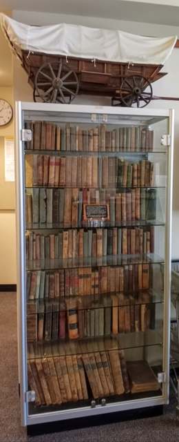
Photo: Tlb440 (Wikimedia Commons), CC BY-SA 4.0 · Wikimedia Commons
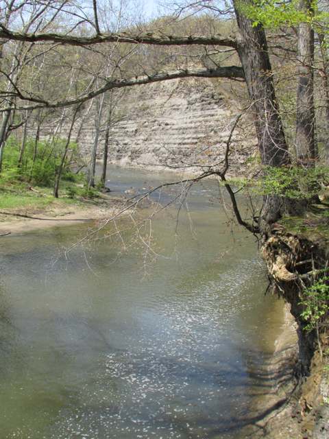
Photo: Chris Light (Wikimedia Commons), CC BY-SA 4.0 · Wikimedia Commons
Local history sources: en.wikipedia.org · north-olmsted.com · clevelandmetroparks.com · commons.wikimedia.org · commons.wikimedia.org
Historic places
3 places in North Olmsted on the National Register of Historic Places. Press a pin or a name for its whole record.
-
First Universalist Church of OlmstedBuilding · North Olmsted · listed 1980
- Address
- 5050 Porter Rd.
- Where
- North Olmsted, Cuyahoga County · ZIP 44070
- What it is
- Building
- Listed on the National Register
- 1980
- NRIS reference number
- 80002983
- Coordinates
- 41.41620, -81.92899
National Register file (NPS) ↗ Search Wikipedia ↗ Street map and directions ↗ On the Cracked Buckeye map
-
Fort HillSite · North Olmsted · listed 1974
- Address
- E of North Olmsted off OH 252
- Where
- North Olmsted, Cuyahoga County · ZIP 44070
- What it is
- Site
- Listed on the National Register
- 1974
- NRIS reference number
- 74001460
- Coordinates
- 41.40933, -81.88642
National Register file (NPS) ↗ Search Wikipedia ↗ Street map and directions ↗ On the Cracked Buckeye map
-
North Olmsted Town HallBuilding · North Olmsted · listed 1980
- Address
- 5186 Dover Center Rd.
- Where
- North Olmsted, Cuyahoga County · ZIP 44070
- What it is
- Building
- Listed on the National Register
- 1980
- NRIS reference number
- 80002984
- Coordinates
- 41.41408, -81.92393
National Register file (NPS) ↗ Search Wikipedia ↗ Street map and directions ↗ On the Cracked Buckeye map
Source: National Park Service, National Register of Historic Places point file. The listing year is shown where NPS's certification date agrees with the listing's reference number. Listing recognizes significance; it does not restrict a private owner.
Water
Lake Erie, through an 8-foot pipe running 2.5 miles offshore from the Westlake shoreline The water here
- Cleveland Public Water System100% of residentsLake Erie
Hospitals, fire stations and more
Inside North Olmsted's boundary: 3 nursing homes, 2 fire and EMS stations, 6 public schools, 1 private school, 2 poor-rated bridges, 1 library, 1 museum, 1 police station, 3 public charging sites and 10 spill cases. Press a pin or a name for its whole record and its source.
Nursing homes (3)
-
Gardens of North Olmsted2 of 5 stars · North Olmsted
- Address
- 23225 Lorain Rd, North Olmsted, OH 44070
- Certified beds
- 99
- Residents on an average day
- 84
- Medicare overall rating
- 2 of 5 stars
- Health inspections
- 1 of 5 stars
- Staffing
- 1 of 5 stars
- Quality measures
- 5 of 5 stars
- Penalties since 2023
- 1 payment denial (latest 2025-11-13)
- Ownership
- For profit - Partnership
- Takes
- Medicare and Medicaid
- Phone
- (440) 779-6900
- Medicare ID
- 365310
Medicare Care Compare ↗ CMS nursing home data (source) ↗ Street map and directions ↗
-
Joshua Tree Care Center4 of 5 stars · North Olmsted
- Address
- 27500 Mill Rd, North Olmsted, OH 44070
- Certified beds
- 36
- Residents on an average day
- 34
- Medicare overall rating
- 4 of 5 stars
- Health inspections
- 4 of 5 stars
- Staffing
- 2 of 5 stars
- Quality measures
- 4 of 5 stars
- Penalties since 2023
- none
- Ownership
- For profit - Individual
- Takes
- Medicare and Medicaid
- Phone
- (440) 777-8444
- Medicare ID
- 365533
Medicare Care Compare ↗ CMS nursing home data (source) ↗ Street map and directions ↗
-
O'Neill Healthcare North Olmsted4 of 5 stars · North Olmsted
- Address
- 4800 Clague Road, North Olmsted, OH 44070
- Certified beds
- 67
- Residents on an average day
- 49
- Medicare overall rating
- 4 of 5 stars
- Health inspections
- 3 of 5 stars
- Staffing
- 2 of 5 stars
- Quality measures
- 5 of 5 stars
- Penalties since 2023
- none
- Ownership
- For profit - Corporation
- Chain
- O'NEILL HEALTHCARE
- Continuing care retirement community
- Yes
- Takes
- Medicare and Medicaid
- Phone
- (440) 734-9933
- Medicare ID
- 366272
Medicare Care Compare ↗ CMS nursing home data (source) ↗ Street map and directions ↗
Source: CMS Care Compare nursing home provider and penalties files; Medicare star ratings run 1 to 5.
Fire and EMS stations (2)
-
North Olmsted Fire Department Station 1North Olmsted
- Address
- 24291 Lorain Road, North Olmsted, OH 44070
- Coordinates
- 41.42736, -81.89074
USGS National Map structures (source) ↗ Street map and directions ↗
-
North Olmsted Fire Department Station 2North Olmsted
- Address
- 29592 Lorain Road, North Olmsted, OH 44070
- Coordinates
- 41.40524, -81.94830
USGS National Map structures (source) ↗ Street map and directions ↗
Source: USGS National Map structures (most Ohio records last updated 2019 to 2022), checked against the Columbus and Cleveland station lists. The department that answers a call is set by jurisdiction and mutual aid, not by distance.
Public schools (6)
-
Birch Primary School4 of 5 stars · North Olmsted
- Address
- 24100 Palm Dr, North Olmsted, OH 44070
- School district
- North Olmsted City School District
- Kind (NCES)
- Regular School
- Students, 2023-24
- 355
- Teachers (full-time equivalent)
- 22.95
- Report card, 2025-26
- 4 of 5 stars
- Ohio building IRN
- 111062
- NCES school ID
- 390445204399
NCES school record ↗ Ohio School Report Card ↗ Street map and directions ↗
-
Chestnut Elementary School4 of 5 stars · North Olmsted
- Address
- 30395 Lorain Rd, North Olmsted, OH 44070
- School district
- North Olmsted City School District
- Kind (NCES)
- Regular School
- Students, 2023-24
- 376
- Teachers (full-time equivalent)
- 23.31
- Report card, 2025-26
- 4 of 5 stars
- Performance index
- 79.9%
- Ohio building IRN
- 006189
- NCES school ID
- 390445204542
NCES school record ↗ Ohio School Report Card ↗ Street map and directions ↗
-
Maple Elementary School4.5 of 5 stars · North Olmsted
- Address
- 24101 Maple Ridge Rd, North Olmsted, OH 44070
- School district
- North Olmsted City School District
- Kind (NCES)
- Regular School
- Students, 2023-24
- 364
- Teachers (full-time equivalent)
- 22.58
- Report card, 2025-26
- 4.5 of 5 stars
- Performance index
- 87%
- Ohio building IRN
- 022533
- NCES school ID
- 390445201431
NCES school record ↗ Ohio School Report Card ↗ Street map and directions ↗
-
North Olmsted High School3.5 of 5 stars · North Olmsted
- Address
- 27301 Butternut Ridge Rd, North Olmsted, OH 44070
- School district
- North Olmsted City School District
- Kind (NCES)
- Regular School
- Students, 2023-24
- 1,145
- Teachers (full-time equivalent)
- 58.79
- Report card, 2025-26
- 3.5 of 5 stars
- Performance index
- 81.4%
- Four-year graduation rate
- 96.4%
- Ohio building IRN
- 026302
- NCES school ID
- 390445201432
NCES school record ↗ Ohio School Report Card ↗ Street map and directions ↗
-
North Olmsted Middle School4 of 5 stars · North Olmsted
- Address
- 27401 Butternut Ridge Rd, North Olmsted, OH 44070
- School district
- North Olmsted City School District
- Kind (NCES)
- Regular School
- Students, 2023-24
- 800
- Teachers (full-time equivalent)
- 41.96
- Report card, 2025-26
- 4 of 5 stars
- Performance index
- 75.5%
- Ohio building IRN
- 026310
- NCES school ID
- 390445201433
NCES school record ↗ Ohio School Report Card ↗ Street map and directions ↗
-
Pine Intermediate School4 of 5 stars · North Olmsted
- Address
- 4267 Dover Center Rd, North Olmsted, OH 44070
- School district
- North Olmsted City School District
- Kind (NCES)
- Regular School
- Students, 2023-24
- 550
- Teachers (full-time equivalent)
- 24.59
- Report card, 2025-26
- 4 of 5 stars
- Performance index
- 83.7%
- Ohio building IRN
- 030023
- NCES school ID
- 390445201434
NCES school record ↗ Ohio School Report Card ↗ Street map and directions ↗
Source: NCES EDGE public school locations 2024-25 and Common Core of Data 2023-24 (type, students, teachers); Ohio School Report Cards 2025-26 (Department of Education and Workforce), matched by name within the district.
Private schools (1)
-
St Brendan Catholic SchoolPrivate, Catholic · North Olmsted
- Address
- 4242 Brendan Ln, North Olmsted, OH 44070
- Kind
- Catholic
- Students, 2023-24
- 129
- Teachers (full-time equivalent)
- 13.6
- Students per teacher
- 9.48529
- Phone
- (440) 777-8433
- NCES private school ID
- 01059304
Source: NCES Private School Survey 2023-24.
Bridges rated poor (2)
-
Cedar Point Rd 193 over Rocky RiverPoor · built 1929
- Condition
- Poor: a deck, superstructure, substructure or culvert rated 4 or below on the 0 to 9 scale
- What it is
- Bridge
- Built
- 1929
- Length
- 56 ft
- Owner
- County
- Vehicles a day
- 2,612
- Coordinates
- 41.40637, -81.88737
National Bridge Inventory (source) ↗ Street map and directions ↗
-
SR 252 over I-480 (grt Nrthrn Blvd)Poor · built 1980
- Condition
- Poor: a deck, superstructure, substructure or culvert rated 4 or below on the 0 to 9 scale
- What it is
- Bridge
- Built
- 1980
- Length
- 89 ft
- Owner
- State
- Vehicles a day
- 19,407
- Coordinates
- 41.41298, -81.90200
National Bridge Inventory (source) ↗ Street map and directions ↗
Source: FHWA National Bridge Inventory 2025. "Poor" means one major part rated 4 or below on the 0 to 9 scale; it calls for repair, not closing, unless the state posts or closes the bridge.
Public libraries (1)
-
North Olmsted Branch LibraryBranch · North Olmsted
- Address
- 27403 Lorain Rd, North Olmsted, OH 44070
- What it is
- Branch
- Library system
- Cuyahoga County Public Library
- Open
- 3,460 hours a year, 52 weeks
- Building
- 37,897 sq ft
- System's visits, FY2024
- 3,917,784
- System's loans, FY2024
- 11,584,178
- People the system serves
- 626,288
- Phone
- (440) 777-6211
IMLS Public Libraries Survey (source) ↗ Street map and directions ↗
Source: IMLS Public Libraries Survey FY2024 (outlets and their systems). Any Ohio resident can get a free card at any Ohio public library.
Museums, historical societies, gardens and zoos (1)
-
Olmsted Historical SocietyHistorical society · North Olmsted
- What it is
- Historical society
- City
- North Olmsted
- Coordinates
- 41.40634, -81.89259
Search Wikipedia ↗ IMLS Museum Data Files (source) ↗ Street map and directions ↗
The museum list is IMLS's 2018 file; a museum may have closed or moved since.
Source: IMLS Museum Data Files, 2018.
Police stations (1)
-
North Olmsted City Police DepartmentNorth Olmsted
- Address
- 27243 Lorain Road, North Olmsted, OH 44070
- Coordinates
- 41.41463, -81.92386
USGS National Map structures (source) ↗ Street map and directions ↗
Source: USGS National Map structures, police stations, corrected and completed by hand (September 2026). The department that answers a call is set by jurisdiction, not by distance.
Public EV charging (3)
-
24601 Country Club Blvd4 Level 2 · N Olmsted
- Address
- 24601 Country Club Blvd, N Olmsted, OH 44070
- Ports
- 4 Level 2
- Plugs
- J1772
- Network
- LOOP
- Hours
- 24 hours daily
- Price
- $1 activation fee; $0.46 per kWh
- Phone
- 888-385-6671
Station Locator (NREL) ↗ Alternative Fuels Data Center (source) ↗ Street map and directions ↗
-
La Quinta Inn & Suites by Wyndham Cleveland Airport West DC fast6 DC fast · North Olmsted
- Address
- 25105 Country Club Blvd, North Olmsted, OH 44070
- Ports
- 6 DC fast
- Plugs
- CCS
- Network
- UNIVERSAL
- Hours
- 24 Hours Daily
- Phone
- 866-350-2738
Station Locator (NREL) ↗ Alternative Fuels Data Center (source) ↗ Street map and directions ↗
-
R1 BENZ STATION 12 Level 2 · North Olmsted
- Address
- 28450 Lorain Rd, North Olmsted, OH 44070
- Ports
- 2 Level 2
- Plugs
- J1772
- Network
- ChargePoint Network
- Hours
- 24 hours daily
- Phone
- 888-758-4389
Station Locator (NREL) ↗ Alternative Fuels Data Center (source) ↗ Street map and directions ↗
Source: NREL Alternative Fuels Data Center station list (May 2026), public and open stations, the posts at one address counted as one site.
Spills reported since 2021 (10)
-
Oil Hydraulic Fluid(S)2025-12-18 · North Olmsted
- Reported
- 2025-12-18
- What spilled
- Oil Hydraulic Fluid(S)
- Largest amount reported
- 1 gallons
- Where
- North Olmsted, Cuyahoga County
- Ohio EPA district office
- NEDO
- Ohio EPA case number
- 2512EPA0002018
Ohio EPA spill reports (source) ↗ Street map and directions ↗
-
Tires2024-09-13 · North Olmsted
- Reported
- 2024-09-13
- What spilled
- Tires
- Where
- North Olmsted, Cuyahoga County
- Ohio EPA district office
- NEDO
- Ohio EPA case number
- 2409EPA0001577
Ohio EPA spill reports (source) ↗ Street map and directions ↗
-
Fuel Diesel / Diesel Fuel (Vehicle On Or Off Road)2024-01-09 · North Olmsted
- Reported
- 2024-01-09
- What spilled
- Fuel Diesel / Diesel Fuel (Vehicle On Or Off Road)
- Largest amount reported
- 40 gallons
- Where
- North Olmsted, Cuyahoga County
- Ohio EPA district office
- NEDO
- Ohio EPA case number
- 2401EPA0000052
Ohio EPA spill reports (source) ↗ Street map and directions ↗
-
Hydrochloric Acid / Muriatic Acid (Hcl)2023-10-18 · North Olmsted
- Reported
- 2023-10-18
- What spilled
- Hydrochloric Acid / Muriatic Acid (Hcl)
- Largest amount reported
- 8 gallons
- Where
- North Olmsted, Cuyahoga County
- Ohio EPA district office
- NEDO
- Ohio EPA case number
- 2310EPA0001793
Ohio EPA spill reports (source) ↗ Street map and directions ↗
-
Sheen Rainbow / Hydrocarbon Reached water2023-10-05 · North Olmsted
- Reported
- 2023-10-05
- What spilled
- Sheen Rainbow / Hydrocarbon; Oil Hydraulic Fluid(S)
- Reached a waterway
- 18 - Rocky River
- Where
- North Olmsted, Cuyahoga County
- Ohio EPA district office
- NEDO
- Ohio EPA case number
- 2310EPA0001723
Ohio EPA spill reports (source) ↗ Street map and directions ↗
-
Oil Hydraulic Fluid(S)2023-09-21 · North Olmsted
- Reported
- 2023-09-21
- What spilled
- Oil Hydraulic Fluid(S)
- Largest amount reported
- 45 gallons
- Where
- North Olmsted, Cuyahoga County
- Ohio EPA district office
- NEDO
- Ohio EPA case number
- 2309EPA0001648
Ohio EPA spill reports (source) ↗ Street map and directions ↗
-
Material White2022-08-02 · North Olmsted
- Reported
- 2022-08-02
- What spilled
- Material White
- Where
- North Olmsted, Cuyahoga County
- Ohio EPA district office
- NEDO
- Ohio EPA case number
- 2208EPA0001167
Ohio EPA spill reports (source) ↗ Street map and directions ↗
-
Sewage Human2021-08-14 · North Olmsted
- Reported
- 2021-08-14
- What spilled
- Sewage Human
- Where
- North Olmsted, Cuyahoga County
- Ohio EPA district office
- NEDO
- Ohio EPA case number
- 2108EPA0001252
Ohio EPA spill reports (source) ↗ Street map and directions ↗
-
Material Gray Reached water2026-07-17 · North Olmsted
- Reported
- 2026-07-17
- What spilled
- Material Gray
- Reached a waterway
- 18 - Rocky River
- Where
- North Olmsted, Cuyahoga County
- Ohio EPA district office
- NEDO
- Ohio EPA case number
- 2607EPA0001305
Ohio EPA spill reports (source) ↗ Street map and directions ↗
-
Oil Hydraulic Fluid(S)2026-04-27 · North Olmsted
- Reported
- 2026-04-27
- What spilled
- Oil Hydraulic Fluid(S)
- Largest amount reported
- 20 gallons
- Where
- North Olmsted, Cuyahoga County
- Ohio EPA district office
- NEDO
- Ohio EPA case number
- 2604EPA0000703
Ohio EPA spill reports (source) ↗ Street map and directions ↗
Source: Ohio EPA emergency response spill reports, 2021 to September 2026, one point per case where Ohio EPA placed it. A report is what the caller or responder recorded; amounts are often blank or estimated.
Its ZIP codes
Each ZIP code that touches North Olmsted, with the share of its residents who live here and the same headline figures as the ZIP page.
| ZIP | Share | Water | Radon | Home value | Schools | Flood |
|---|---|---|---|---|---|---|
| 44070 North Olmsted | 100% | Lake Erie, through an 8-foot pipe running 2.5 miles offshore from the Westlake shoreline | 3.7 pCi/L average radon | Median year built 1964 | North Olmsted City · 4 stars overall | 2.0% of residents in the 1% floodplain |
Local government
Who holds office in North Olmsted, how its elections and ballot issues came out, and the state auditor's record.
Who holds office
| Office | Name | Party | Term ends | Contact |
|---|---|---|---|---|
| Board President (North Olmsted City Schools) | Gina Lehmann | Gina.Lehmann@nolmsted.org | ||
| Board Vice President (North Olmsted City Schools) | Dan Rahm | Daniel.Rahm@nolmsted.org | ||
| Board Member (North Olmsted City Schools) | Mohammad Alhawawsha | Mohammad.Alhawawsha@nolmsted.org | ||
| Board Member (North Olmsted City Schools) | Terry Groden | Terry.Groden@nolmsted.org | ||
| Board Member (North Olmsted City Schools) | Megan Murphy | Megan.Murphy@nolmsted.org |
Roster as of 2026-09-18: county board of elections.
Auditor of State record
- No fiscal caution, watch or emergency on the Auditor of State's lists.
- Financial Health Indicators (the Auditor of State's 17 measures; critical / cautionary / positive): 2019 1 / 2 / 14; 2020 2 / 3 / 12; 2021 2 / 2 / 13; 2022 1 / 2 / 14; 2023 1 / 4 / 12; 2024 2 / 4 / 11.
- Financial Audit, 2025, released 2026-09-10
- OP&F Examination, 2024, released 2026-05-14
- Financial Audit, 2024, released 2025-08-26
- Compliance Examination, 2024, released 2025-07-22
- OPERS Examination, 2024, released 2025-05-08
The county
Cuyahoga County: 52 ZIP codes, 59 cities, villages and townships, 1,270,867 people.
Nearby places
No nearby place shares a ZIP code with North Olmsted in the atlas yet.
Rain and snow
How much has actually fallen on North Olmsted, day by day, from 1871 to now. Daily totals, not averages.
- rain, last 30 days
- 2.60 in
- 2026-10-01 to 2026-10-30
- rain so far in 2026
- 33.8 in
- about normal for the date
- snow so far in 2026
- 34.1 in
- a normal year brings 60.9 in
- a normal year
- 41.2 in
- average of 30 years, 1991-2020
| Month | Rain (in) | Snow (in) | Days counted |
|---|---|---|---|
| October 2026 | 2.60 | — | 30 |
| September 2026 | 2.41 | — | 30 |
| August 2026 | 6.00 | — | 31 |
| July 2026 | 3.52 | — | 31 |
| June 2026 | 3.05 | — | 30 |
| May 2026 | 4.14 | — | 31 |
| April 2026 | 5.88 | — | 30 |
| March 2026 | 3.65 | 1.3 | 31 |
| February 2026 | 0.55 | 6.4 | 28 |
| January 2026 | 1.95 | 26.4 | 31 |
| December 2025 | 2.42 | 13.8 | 31 |
| November 2025 | 2.10 | 4.6 | 30 |
| Wettest year | 2011 — 64.4 in |
|---|---|
| Driest year | 1963 — 18.4 in |
| Snowiest year | 2005 — 102.4 in |
| Wettest day on record | 7 September 1996 — 4.71 in |
| Heaviest snowfall in a day | 25 November 1950 — 13.29 in |
| Deepest snow on the ground | 5 February 2009 — 20.61 in |
Estimated, not measured. No rain gauge has ever stood inside North Olmsted, so every figure here is worked out from the gauges around it - the nearest ones weighted most. Treat them as close estimates rather than readings.
56,916 days of records, 1871-01-01 to 2026-10-30. Source: NOAA NCEI GHCN-Daily, 3,240 gauges in and around Ohio. A day is "gauged" when a gauge standing inside the boundary reported it, and the value is the mean of those gauges. Otherwise it is interpolated by inverse distance from every gauge reporting within 50 miles. Nothing is carried forward, back-filled or smoothed. Against NOAA nClimDiv county monthly precipitation over 136,848 complete county-months (checked 2026-11-01): correlation 0.9515, median absolute difference 0.217 in a month. Built 2026-11-01 from the Cracked Buckeye precipitation archive. Snow is the softer number — snowfall is measured by hand with a ruler, no agency publishes a gridded county snowfall series, and blowing snow defeats every observer.
Environmental permits and filings
What Ohio EPA has on file for North Olmsted: permits, inspections, violations, cleanups and the state loans behind sewer and water work. Every line links to the agency's own document.
- facilities and sites on file
- 45
- those placed on the map inside North Olmsted
| Program | Facilities and sites |
|---|---|
| Wastewater and stormwater discharge | 16 |
| Hazardous waste | 10 |
| Air pollution | 7 |
| Wetland and stream fill | 5 |
| State sewer loans | 4 |
| Contaminated-site cleanup | 1 |
| Sewer and water-line construction | 1 |
| Underground injection wells | 1 |
| Date | Facility or site | What |
|---|---|---|
| STEARNS RD SINGLE FAMILY HOME | Wetland and stream fill permit | |
| NORTH OLMSTED JEEP DEALERSHIP | Wastewater and stormwater discharge permit | |
| NORTH OLMSTED JEEP DEALERSHIP | Wastewater and stormwater discharge permit | |
| SHEETZ - NORTH OLMSTED | Wastewater and stormwater discharge permit | |
| WATER TOWER SQUARE | Hazardous waste assessment | |
| STEARNS RD SINGLE FAMILY HOME | Wetland and stream fill permit | |
| STEARNS RD SINGLE FAMILY HOME | Wetland and stream fill permit | |
| STEARNS RD SINGLE FAMILY HOME | Wetland and stream fill permit | |
| STEARNS RD SINGLE FAMILY HOME | Wetland and stream fill permit | |
| OFFICE WAREHOUSE BASIN RELOCATION | Wastewater and stormwater discharge permit | |
| STEARNS RD SINGLE FAMILY HOME | Wetland and stream fill permit | |
| STEARNS RD SINGLE FAMILY HOME | Wetland and stream fill permit | |
| CULVER'S - NORTH OLMSTED OH | Wastewater and stormwater discharge permit | |
| WATER TOWER SQUARE | Hazardous waste inspection | |
| SOUTH INTERCEPTOR EQUALIZATION TANK PROJECT | Wetland and stream fill permit | |
| JP MORGAN CHASE BANK - NORTH OLMSTED | Wastewater and stormwater discharge permit | |
| HALLEEN KIA - NORTH OLMSTED | Wastewater and stormwater discharge permit | |
| JL MOORE PROPERTY | Wastewater and stormwater discharge permit | |
| PIR 3960 – FITCH AND BUTTERNUT | Wastewater and stormwater discharge permit | |
| FOREST COMMONS | Wastewater and stormwater discharge permit | |
| SOUTH INTERCEPTOR EQUALIZATION FACILITY | Wastewater and stormwater discharge permit | |
| ROCKY RIVER NATURE CENTER SHORELINE PROTECTION | Wetland and stream fill permit | |
| N OLMSTED COMMUNITY PARK PHASE 2 IMPROVEMENTS | Wastewater and stormwater discharge permit | |
| SOUTH INTERCEPTOR EQUALIZATION FACILITY | Wastewater and stormwater discharge permit | |
| ROCKY RIVER NATURE CENTER SHORELINE PROTECTION | Wetland and stream fill permit |
Source: Ohio EPA eDocument portal (edocpub.epa.ohio.gov), indexed 2026-10-14. Facilities are placed on the map from Ohio EPA's own map layers, EPA's Facility Registry, coordinates written in the filings, or a geocoded street address. A permit filed under a private person's name (most are household septic systems) is counted but never named, placed or linked; licenses for individual workers and open-burning notices are left out entirely.
Quick answers
What county is North Olmsted, Ohio in?
North Olmsted is a city in Cuyahoga County, Ohio, with 32,442 residents.
When was North Olmsted, Ohio founded?
North Olmsted was settled 1815 (David Johnson, first settler); incorporated 1823 (Lenox Township); 1826 (renamed Olmsted); 1909 (city). Founders on record: David Johnson, son of Vermont settler Elijah Stearns. Source
How did North Olmsted, Ohio get its name?
The township was first called Plum Creek (1807), then Kingston (1814), then organized as Lenox Township in 1823. Source
What ZIP code is North Olmsted, Ohio?
Most of North Olmsted is in ZIP code 44070.
Where does North Olmsted, Ohio get its water?
The main water source for North Olmsted (Cleveland Public Water System): Lake Erie, through an 8-foot pipe running 2.5 miles offshore from the Westlake shoreline.
Cite this page
Cite this page as:
Cracked Buckeye, "North Olmsted, Cuyahoga County", https://crackedbuckeye.com/place/north-olmsted/, built 2026-10-31, accessed [date].
How to cite · Report a correction · Built 2026-10-31