Local events in North Hampton
Nothing is posted for North Hampton itself yet; here is what is on within 10 miles. All local events in North Hampton
Know a calendar we should watch? Send the link
Checked October 20; the events page is refreshed daily.
How North Hampton began
North Hampton sits in the eastern part of Pike Township in the northwest corner of Clark County, the only village Pike Township ever laid out. Peter Baisinger platted it on January 13, 1829, with sixteen original lots surveyed by Reuben Miller, and a post office followed in the 1830s. It grew slowly as a farm-trade crossroads village around mills on Donnels Creek and Honey Creek rather than as a railroad or industrial town, and it stayed small: 457 residents in 2020, about the same as a century earlier. Note: several National Register listings sometimes associated with North Hampton (Arcade Hotel, Brewer Log House, Lagonda Club, Lagonda National Bank, Main Street Buildings, Masonic Temple, Municipal Building, Old Enon Road Stone Arch Culvert) belong to ZIP 45502, which is Springfield's own downtown, not North Hampton village; they are not part of this village's history and are omitted below.
Platted 1829-01-13, by Peter Baisinger, who platted the village on January 13, 1829, with the survey and plat made by Reuben Miller.
Where the name comes from
No source found explains why the village was called North Hampton. It is not connected in the record to Northampton, Massachusetts, the way Northampton Township in Summit County is (that township's first settler, Simeon Prior, named it for his Massachusetts hometown). The 1881 county history, which names the platter (Peter Baisinger) and surveyor (Reuben Miller), gives no reasoning for the name, and no other source found does either; we have not guessed at one.
Before the town
Nothing specific to North Hampton village or Pike Township itself is recorded in the sources checked: no named village, mound, trail, or treaty line tied to this exact spot. The county-level picture is that Clark County lies on and near the Mad River, home to the historic Shawnee town the Shawnee called Piqua (also written Pickaway or Picawey), located roughly seven miles west of present Springfield in what is now Bethel Township. Piqua was the Shawnee capital and birthplace claimed by Tecumseh; on August 8, 1780, some 970 Kentucky militia under Gen. George Rogers Clark, retaliating for raids on Kentucky settlements, defeated Shawnee warriors led by Black Hoof (with Lenape, Wyandot, and Mingo allies) at Piqua, burned the town, and destroyed roughly 500 acres of standing corn; the Shawnee then resettled on the Great Miami River at a new town they also called Piqua (Peckuwe), giving today's city of Piqua its name. Pike Township, where North Hampton stands, is roughly 15-20 miles northwest of that battle site, within the broader area the Mad River Shawnee and their neighbors used, but no source found places a specific village, camp, or trail inside Pike Township's boundaries.
Nations recorded here: Shawnee.
- Piqua (Shawnee town, also Pickaway/Picawey) (village) — Mad River, about 7 miles west of Springfield, now Bethel Township, Clark County, destroyed August 8, 1780 (en.wikipedia.org)
Timeline
- — Clark County's commissioners organize Pike Township, in the county's northwest corner, as one of the original ten townships.
- — Peter Baisinger plats North Hampton, the only village ever laid out in Pike Township, with sixteen lots surveyed by Reuben Miller.
- — First merchant Joseph Smith, trading on $150 of capital, builds the village's first frame house on Lot 15; it is later moved to Lot 3 and used as a store and dwelling.
- — Alexander Johnston opens the township's first hotel at the southeast corner of North Hampton's cross streets; he dies of typhoid fever about 1843 during an outbreak in the township.
- — A post office opens at North Hampton with Daniel Raffensperger as first postmaster (Wikipedia gives 1839 for the post office's start; the 1881 county history, compiled closer to the event, gives 1835 — both are recorded here since the sources disagree).
- — Construction begins on the North Hampton and Donnelsville Turnpike, the first graveled road built from the village.
- — The German Reformed congregation dedicates its North Hampton church in November, organizing with 21 members that grew to 37 within days.
- — The rock band Vanilla Fudge is mistakenly routed to North Hampton instead of Northampton Township's Blossom Music Center for a scheduled concert and arrives four hours late by chartered plane after the mix-up is discovered.
- — The U.S. Census records 457 residents, down from 478 in 2010.
- — North Hampton's mayor's court processes 1,065 new cases, the third-busiest mayor's court per capita in Ohio, reflecting the village's long-standing reputation as a speed trap on its state-route frontage.
Stories
A village boxed in by its neighbors' fields
The 1881 county history says plainly that North Hampton "has always been circumscribed and dwarfed in growth by a lack of building lots, parties owning the adjoining farms not wishing to part with lots." Peter Baisinger's 1829 plat held only sixteen lots to begin with, and the farmers who owned the land ringing the village simply declined to sell more ground for expansion. By 1881 the population was still only about two hundred. That same stubbornness protected the town's original street pattern: the first frame store Joseph Smith built in 1830 on a $150 stake was still standing fifty years later, moved once but never replaced, doing duty as a dwelling under the ownership of a Mrs. Turner.
The wrong North Hampton
In 1969 the rock band Vanilla Fudge was booked to play Blossom Music Center, then new, in Northampton Township near Cleveland. According to band member Mark Stein, a promoter's confused directions sent their agent looking at a map for "Northampton" and landing instead on North Hampton, the small Clark County village near Dayton, more than a hundred miles from the real venue. The band and crew realized the mistake only after arriving in the wrong North Hampton, and had to charter a plane to reach Blossom, arriving four hours late for their own show. The story has stuck to the village ever since as its odd claim to national attention.
Photographs
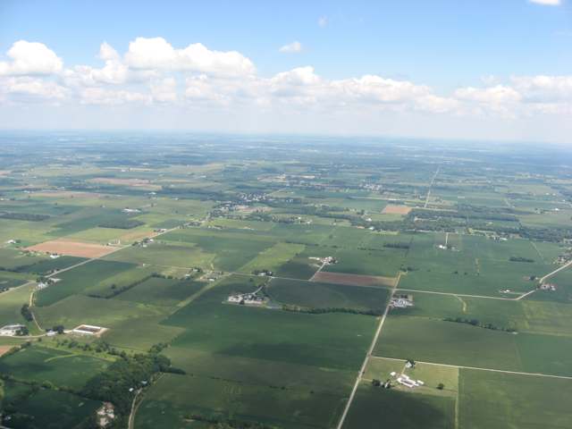
Photo: Nyttend, public domain · Wikimedia Commons
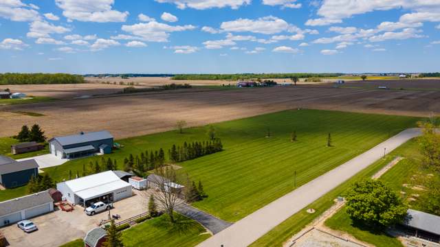
Photo: Logan Rickert (Flickr user loganrickert), CC BY 2.0 · Wikimedia Commons
Local history sources: en.wikipedia.org · en.wikipedia.org · archive.org · en.wikipedia.org · kids.kiddle.co · commons.wikimedia.org · commons.wikimedia.org
Water
Groundwater wells (2 wells) The water here
- North Hampton Village93% of residentsGroundwater wells (2 wells)
- Springfield City3% of residentsMad River Buried Valley Aquifer (12 wells)
- Clark County Northridge2% of residentsMad River Buried Valley Aquifer (12 wells)
- Clark County Lawrenceville1% of residentsGroundwater wells (2 wells)
- Chateau Estates MHP1% of residentsGroundwater wells (2 wells)
- Rolling Terrace MHP0% of residentsGroundwater wells (2 wells)
Hospitals, fire stations and more
Inside North Hampton's boundary: 1 police station. Press a pin or a name for its whole record and its source.
Police stations (1)
-
North Hampton Police DepartmentNorth Hampton
- Address
- 250 West Clark Street, North Hampton, OH 45349
- Coordinates
- 39.99119, -83.94854
USGS National Map structures (source) ↗ Street map and directions ↗
Source: USGS National Map structures, police stations, corrected and completed by hand (September 2026). The department that answers a call is set by jurisdiction, not by distance.
Its ZIP codes
Each ZIP code that touches North Hampton, with the share of its residents who live here and the same headline figures as the ZIP page.
| ZIP | Share | Water | Radon | Home value | Schools | Flood |
|---|---|---|---|---|---|---|
| 45349 North Hampton | 100% | Groundwater wells (2 wells) | 3.6 pCi/L average radon | Median year built 1911 | Northwestern Local · 3.5 stars overall | 0.0% of residents in the 1% floodplain |
| 45502 German Township and Springfield | 1% | Mostly private wells | 6.8 pCi/L average radon | Median year built 1976 | Northwestern Local · 3.5 stars overall | 1.4% of residents in the 1% floodplain |
Local government
Who holds office in North Hampton, how its elections and ballot issues came out, and the state auditor's record.
Money issues on the ballot since 2020: 1 of 1 passed.
Ballot issues
| Date | Issue | For | Against | Result |
|---|---|---|---|---|
| 2020-11-03 | Issue: VILLAGE OF NORTH HAMPTON | 160 | 94 | Passed (62.99% for) |
Elections for office
| Date | Office | Candidates and votes |
|---|---|---|
| 2019-11-05 | Mayor | David G. Young 46, 100.0% |
Winners in bold. Results from the county board of elections' official canvass unless marked.
Auditor of State record
- No fiscal caution, watch or emergency on the Auditor of State's lists.
- Financial Audit, 2022 to 2023, released 2024-11-07
The county
Clark County: 15 ZIP codes, 19 cities, villages and townships, 135,514 people.
Nearby places
Rain and snow
How much has actually fallen on North Hampton, day by day, from 1894 to now. Daily totals, not averages.
- rain, last 30 days
- 1.53 in
- 2026-09-30 to 2026-10-29
- rain so far in 2026
- 42.4 in
- 6.8 in above normal for the date
- snow so far in 2026
- 20.4 in
- a normal year brings 17.5 in
- a normal year
- 41.9 in
- average of 30 years, 1991-2020
| Month | Rain (in) | Snow (in) | Days counted |
|---|---|---|---|
| October 2026 | 1.53 | — | 29 |
| September 2026 | 4.50 | — | 30 |
| August 2026 | 7.00 | — | 31 |
| July 2026 | 3.02 | — | 31 |
| June 2026 | 3.54 | — | 30 |
| May 2026 | 9.23 | — | 31 |
| April 2026 | 3.19 | — | 30 |
| March 2026 | 6.90 | 1.5 | 31 |
| February 2026 | 1.76 | 4.3 | 28 |
| January 2026 | 1.74 | 14.5 | 31 |
| December 2025 | 2.19 | 8.3 | 31 |
| November 2025 | 1.99 | 2.7 | 30 |
| Wettest year | 2011 — 60.0 in |
|---|---|
| Driest year | 1934 — 24.6 in |
| Snowiest year | 1910 — 70.7 in |
| Wettest day on record | 26 June 1971 — 4.39 in |
| Heaviest snowfall in a day | 17 February 1910 — 14.49 in |
| Deepest snow on the ground | 21 January 1978 — 18.82 in |
Estimated, not measured. No rain gauge has ever stood inside North Hampton, so every figure here is worked out from the gauges around it - the nearest ones weighted most. Treat them as close estimates rather than readings.
47,749 days of records, 1894-04-01 to 2026-10-29. Source: NOAA NCEI GHCN-Daily, 3,240 gauges in and around Ohio. A day is "gauged" when a gauge standing inside the boundary reported it, and the value is the mean of those gauges. Otherwise it is interpolated by inverse distance from every gauge reporting within 50 miles. Nothing is carried forward, back-filled or smoothed. Against NOAA nClimDiv county monthly precipitation over 136,848 complete county-months (checked 2026-10-31): correlation 0.9515, median absolute difference 0.217 in a month. Built 2026-10-31 from the Cracked Buckeye precipitation archive. Snow is the softer number — snowfall is measured by hand with a ruler, no agency publishes a gridded county snowfall series, and blowing snow defeats every observer.
Quick answers
What county is North Hampton, Ohio in?
North Hampton is a village in Clark County, Ohio, with 457 residents.
When was North Hampton, Ohio founded?
North Hampton was laid out 1829-01-13. Founders on record: Peter Baisinger, who platted the village on January 13, 1829, with the survey and plat made by Reuben Miller. Source
What ZIP code is North Hampton, Ohio?
Most of North Hampton is in ZIP code 45349.
Where does North Hampton, Ohio get its water?
The main water source for North Hampton (North Hampton Village): Groundwater wells (2 wells).
Cite this page
Cite this page as:
Cracked Buckeye, "North Hampton, Clark County", https://crackedbuckeye.com/place/north-hampton/, built 2026-10-31, accessed [date].
How to cite · Report a correction · Built 2026-10-31
