Local events in Monroeville
16 events in the next 90 days from 3 public calendars. All local events in Monroeville
Checked October 20; the events page is refreshed daily.
How Monroeville began
Monroeville was laid out in 1817 as 'Monroe,' honoring President James Monroe, before postal authorities later changed the name to Monroeville to avoid confusion with other Ohio places called Monroe; the village incorporated in 1868. Three of its nineteenth-century buildings -- the 1813 Seth Brown House, the octagonal John Hosford House (c. 1856-62), and Zion Episcopal Church -- were all listed on the National Register of Historic Places on the same day, May 3, 1974. In 2025 the village completed a federally required Long-Term Control Plan, permanently sealing its last combined sewer overflow outfall, a long-running local infrastructure project reaching its finish.
Settled 1817, platted 1817 (as 'Monroe'), incorporated 1868.
Where the name comes from
The settlement was originally laid out and named 'Monroe' in 1817, for President James Monroe; postal authorities later changed the designation to Monroeville to distinguish it from other Ohio places named Monroe.
Before the town
No Native American village, trail, or site specific to Monroeville is documented in the sources consulted.
Timeline
- — The Seth Brown House, later listed on the National Register, is built -- among the oldest documented structures in the village.
- — The settlement is laid out as 'Monroe,' named for President James Monroe.
- — The octagonal John Hosford House is built.
- — Monroeville officially incorporates as a village.
- — The Seth Brown House, John Hosford House, and Zion Episcopal Church are all listed on the National Register of Historic Places on May 3.
- — Council passes rate-review ordinances 2025-09 (sewer, June 10) and 2025-10 (water, August 12), raising both utility rates in phases.
- — The village permanently seals its last combined sewer overflow outfall on November 14, completing its federally required Long-Term Control Plan.
Stories
An octagon house on Sandusky Street
The John Hosford House, built between about 1856 and 1862 at 64 Sandusky Street, follows the eight-sided floor plan that briefly swept the country in the 1850s after Orson Squire Fowler's book 'A Home for All' argued that octagon houses caught more light, wasted less interior space, and cost less to heat than conventional rectangular ones. Few of the octagon houses that fad produced survive intact; Monroeville's example does, and it was listed on the National Register of Historic Places in 1974 alongside two of the village's other nineteenth-century landmarks, the 1813 Seth Brown House and Zion Episcopal Church -- all three recognized on the same day, a rare cluster of listings for a village this small.
Photographs
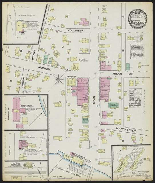
Photo: Sanborn Map Company, via Digital Public Library of America, Public domain · Wikimedia Commons
Local history sources: en.wikipedia.org · en.wikipedia.org · commons.wikimedia.org
Historic places
1 place in Monroeville on the National Register of Historic Places. Press a pin or a name for its whole record.
-
Hosford, John, HouseBuilding · Monroeville · listed 1974
- Address
- 64 Sandusky St.
- Where
- Monroeville, Huron County · ZIP 44847
- What it is
- Building
- Listed on the National Register
- 1974
- NRIS reference number
- 74001532
- Coordinates
- 41.24569, -82.69600
National Register file (NPS) ↗ Search Wikipedia ↗ Street map and directions ↗ On the Cracked Buckeye map
Source: National Park Service, National Register of Historic Places point file. The listing year is shown where NPS's certification date agrees with the listing's reference number. Listing recognizes significance; it does not restrict a private owner.
Water
Mostly private wells The water here
- Monroeville Village100% of residentsWest Branch Huron River, stored in Monroeville's reservoir
Hospitals, fire stations and more
Inside Monroeville's boundary: 1 fire or EMS station, 1 power plant, 2 public schools, 1 private school, 1 library and 1 police station. Press a pin or a name for its whole record and its source.
Fire and EMS stations (1)
-
Huron River Joint Fire DistrictMonroeville
- Address
- 155 Monroe Street, Monroeville, OH 44847
- Coordinates
- 41.24329, -82.70126
USGS National Map structures (source) ↗ Street map and directions ↗
Source: USGS National Map structures (most Ohio records last updated 2019 to 2022), checked against the Columbus and Cleveland station lists. The department that answers a call is set by jurisdiction and mutual aid, not by distance.
Power plants (1)
-
Monroeville RTO BTMPetroleum · 3 MW
- Capacity
- 3 MW
- Main source
- Petroleum
- Technology
- Petroleum Liquids
- Operator
- American Mun Power-Ohio, Inc
- Sector
- Electric Utility
- Where
- Monroeville, Huron County
- Generating units
- 1
- Built
- 2020
- EIA plant code
- 66434
EIA plant page ↗ EIA-860 (source) ↗ Street map and directions ↗
Source: EIA-860 power plant inventory via HIFLD (February 2025), with plant codes, units and years from EIA-860 2025.
Public schools (2)
-
Monroeville Elementary School3 of 5 stars · Monroeville
- Address
- 101 West St, Monroeville, OH 44847
- School district
- Monroeville Local School District
- Kind (NCES)
- Regular School
- Students, 2023-24
- 315
- Teachers (full-time equivalent)
- 18
- Report card, 2025-26
- 3 of 5 stars
- Performance index
- 76.5%
- Ohio building IRN
- 025353
- NCES school ID
- 390477102951
NCES school record ↗ Ohio School Report Card ↗ Street map and directions ↗
-
Monroeville High School4 of 5 stars · Monroeville
- Address
- 101 West St, Monroeville, OH 44847
- School district
- Monroeville Local School District
- Kind (NCES)
- Regular School
- Students, 2023-24
- 249
- Teachers (full-time equivalent)
- 20
- Report card, 2025-26
- 4 of 5 stars
- Performance index
- 76.7%
- Four-year graduation rate
- 98.1%
- Ohio building IRN
- 025361
- NCES school ID
- 390477102952
NCES school record ↗ Ohio School Report Card ↗ Street map and directions ↗
Source: NCES EDGE public school locations 2024-25 and Common Core of Data 2023-24 (type, students, teachers); Ohio School Report Cards 2025-26 (Department of Education and Workforce), matched by name within the district.
Private schools (1)
-
St Joseph Catholic SchoolPrivate, Catholic · Monroeville
- Address
- 79 Chapel St, Monroeville, OH 44847
- Kind
- Catholic
- Students, 2023-24
- 63
- Teachers (full-time equivalent)
- 8.3
- Students per teacher
- 7.59036
- Phone
- (419) 465-2625
- NCES private school ID
- 01061073
Source: NCES Private School Survey 2023-24.
Public libraries (1)
-
Monroeville Public LibraryCentral library · Monroeville
- Address
- 34 Monroe St., Monroeville, OH 44847
- What it is
- Central library
- Library system
- Monroeville Public Library
- Open
- 2,080 hours a year, 52 weeks
- Building
- 4,070 sq ft
- System's visits, FY2024
- 10,400
- System's loans, FY2024
- 21,904
- People the system serves
- 3,918
- Phone
- (419) 465-2035
IMLS Public Libraries Survey (source) ↗ Street map and directions ↗
Source: IMLS Public Libraries Survey FY2024 (outlets and their systems). Any Ohio resident can get a free card at any Ohio public library.
Police stations (1)
-
Monroeville Police DepartmentMonroeville
- Address
- 21 North Main Street, Monroeville, OH 44847
- Coordinates
- 41.24426, -82.69553
USGS National Map structures (source) ↗ Street map and directions ↗
Source: USGS National Map structures, police stations, corrected and completed by hand (September 2026). The department that answers a call is set by jurisdiction, not by distance.
Its ZIP codes
Each ZIP code that touches Monroeville, with the share of its residents who live here and the same headline figures as the ZIP page.
| ZIP | Share | Water | Radon | Home value | Schools | Flood |
|---|---|---|---|---|---|---|
| 44847 Monroeville | 37% | Mostly private wells | 9.8 pCi/L average radon | Median year built 1964 | Monroeville Local · 3.5 stars overall | 6.1% of residents in the 1% floodplain |
Local government
Who holds office in Monroeville, how its elections and ballot issues came out, and the state auditor's record.
Ballot issues
| Date | Issue | For | Against | Result |
|---|---|---|---|---|
| 2015-11-03 | Issue: MONROEVILLE VILL LOCAL LIQUOR OPTION | 260 | 59 | Passed (81.5% for) |
Elections for office
| Date | Office | Candidates and votes |
|---|---|---|
| 2023-07-20 | Member of Council | Mark W. Miller 238, 50.64%; Susan Rogers 232, 49.36% |
| 2023-07-20 | Mayor | Joseph Galea 319, 100.0% |
| 2021-11-02 | Member of Council | Bob Whitacre 151, 31.07%; Christina A. Raftery 123, 25.31%; Joseph Galea 112, 23.05%; Samuel C. Wiley 100, 20.58% |
| 2019-11-05 | MAYOR | Melissa M. Fries-Seip 152, 100.0% |
| 2019-11-05 | COUNCIL | Craig Thomas Franklin 119, 48.57%; Susan Rogers 126, 51.43% |
| 2017-11-07 | Member of Council | Bob Whitacre 180, 28.66%; Kevin Rasnick 151, 24.04%; Christina A. Raftery 149, 23.73%; Mark A. Rupp 148, 23.57% |
| 2017-11-07 | Mayor | Melissa Fries 205, 100.0% |
| 2015-11-03 | MAYOR | Withdrawn 0 |
Winners in bold. Results from the county board of elections' official canvass unless marked.
Auditor of State record
- No fiscal caution, watch or emergency on the Auditor of State's lists.
- Financial Audit, 2024, released 2026-01-15
- Financial Audit, 2023, released 2024-09-24
The county
Huron County: 10 ZIP codes, 30 cities, villages and townships, 60,416 people.
Nearby places
Rain and snow
How much has actually fallen on Monroeville, day by day, from 1893 to now. Daily totals, not averages.
- rain, last 30 days
- 2.29 in
- 2026-09-29 to 2026-10-28
- rain so far in 2026
- 35.5 in
- about normal for the date
- snow so far in 2026
- 19.8 in
- a normal year brings 32.4 in
- a normal year
- 39.8 in
- average of 30 years, 1991-2020
| Month | Rain (in) | Snow (in) | Days counted |
|---|---|---|---|
| October 2026 | 2.29 | — | 28 |
| September 2026 | 3.33 | — | 30 |
| August 2026 | 5.36 | — | 31 |
| July 2026 | 5.10 | — | 31 |
| June 2026 | 4.12 | — | 30 |
| May 2026 | 4.76 | — | 31 |
| April 2026 | 6.12 | — | 30 |
| March 2026 | 2.90 | 0.0 | 31 |
| February 2026 | 0.24 | 2.4 | 28 |
| January 2026 | 1.23 | 17.4 | 31 |
| December 2025 | 1.77 | 4.8 | 31 |
| November 2025 | 1.26 | 0.3 | 30 |
| Wettest year | 2011 — 55.4 in |
|---|---|
| Driest year | 1963 — 20.9 in |
| Snowiest year | 1910 — 80.3 in |
| Wettest day on record | 5 July 1969 — 8.49 in |
| Heaviest snowfall in a day | 14 February 2007 — 14.02 in |
| Deepest snow on the ground | 5 February 1978 — 21.80 in |
Estimated, not measured. No rain gauge has ever stood inside Monroeville, so every figure here is worked out from the gauges around it - the nearest ones weighted most. Treat them as close estimates rather than readings.
48,695 days of records, 1893-04-01 to 2026-10-28. Source: NOAA NCEI GHCN-Daily, 3,240 gauges in and around Ohio. A day is "gauged" when a gauge standing inside the boundary reported it, and the value is the mean of those gauges. Otherwise it is interpolated by inverse distance from every gauge reporting within 50 miles. Nothing is carried forward, back-filled or smoothed. Against NOAA nClimDiv county monthly precipitation over 136,848 complete county-months (checked 2026-10-31): correlation 0.9515, median absolute difference 0.217 in a month. Built 2026-10-31 from the Cracked Buckeye precipitation archive. Snow is the softer number — snowfall is measured by hand with a ruler, no agency publishes a gridded county snowfall series, and blowing snow defeats every observer.
Environmental permits and filings
What Ohio EPA has on file for Monroeville: permits, inspections, violations, cleanups and the state loans behind sewer and water work. Every line links to the agency's own document.
- facilities and sites on file
- 14
- those placed on the map inside Monroeville
| Program | Facilities and sites |
|---|---|
| State water loans | 5 |
| Hazardous waste | 4 |
| State sewer loans | 2 |
| Cessation Of Regulated Operations | 1 |
| Public drinking water | 1 |
| Wastewater and stormwater discharge | 1 |
| Date | Facility or site | What |
|---|---|---|
| MONROEVILLE WWTP | Wastewater and stormwater discharge report | |
| MONROEVILLE VILLAGE PWS | Public drinking water report | |
| MONROEVILLE WWTP | Wastewater and stormwater discharge inspection | |
| MONROEVILLE VILLAGE PWS | Public drinking water plan | |
| MONROEVILLE WWTP | Wastewater and stormwater discharge report | |
| MONROEVILLE VILLAGE PWS | Public drinking water inspection | |
| MONROEVILLE VILLAGE PWS | Public drinking water inspection | |
| MONROEVILLE WWTP | Wastewater and stormwater discharge permit | |
| MONROEVILLE VILLAGE PWS | Public drinking water inspection | |
| MONROEVILLE VILLAGE PWS | Public drinking water report | |
| MONROEVILLE WWTP | Wastewater and stormwater discharge report | |
| MONROEVILLE WWTP | Wastewater and stormwater discharge permit | |
| MONROEVILLE WWTP | Wastewater and stormwater discharge report | |
| MONROEVILLE WWTP | Wastewater and stormwater discharge report | |
| MONROEVILLE WWTP | Wastewater and stormwater discharge report | |
| MONROEVILLE VILLAGE PWS | Public drinking water compliance letter | |
| MONROEVILLE VILLAGE PWS | Public drinking water inspection | |
| MONROEVILLE VILLAGE PWS | Public drinking water inspection | |
| MONROEVILLE VILLAGE PWS | Public drinking water compliance letter | |
| MONROEVILLE WWTP | Wastewater and stormwater discharge report | |
| MONROEVILLE WWTP | Wastewater and stormwater discharge report | |
| MONROEVILLE VILLAGE PWS | Public drinking water report | |
| MONROEVILLE WWTP | Wastewater and stormwater discharge permit | |
| MONROEVILLE VILLAGE PWS | Public drinking water compliance letter | |
| MONROEVILLE VILLAGE PWS | Public drinking water plan |
Source: Ohio EPA eDocument portal (edocpub.epa.ohio.gov), indexed 2026-10-14. Facilities are placed on the map from Ohio EPA's own map layers, EPA's Facility Registry, coordinates written in the filings, or a geocoded street address. A permit filed under a private person's name (most are household septic systems) is counted but never named, placed or linked; licenses for individual workers and open-burning notices are left out entirely.
Quick answers
What county is Monroeville, Ohio in?
Monroeville is a village in Huron County, Ohio, with 1,300 residents.
When was Monroeville, Ohio founded?
Monroeville was settled 1817; laid out 1817 (as 'Monroe'); incorporated 1868. Source
How did Monroeville, Ohio get its name?
The settlement was originally laid out and named 'Monroe' in 1817, for President James Monroe; postal authorities later changed the designation to Monroeville to distinguish it from other Ohio places named Monroe. Source
What ZIP code is Monroeville, Ohio?
Most of Monroeville is in ZIP code 44847.
Where does Monroeville, Ohio get its water?
The main water source for Monroeville (Monroeville Village): Mostly private wells.
Cite this page
Cite this page as:
Cracked Buckeye, "Monroeville, Huron County", https://crackedbuckeye.com/place/monroeville/, built 2026-10-31, accessed [date].
How to cite · Report a correction · Built 2026-10-31
