Local events in Kenton
60 events in the next 90 days from 6 public calendars. All local events in Kenton
Checked October 20; the events page is refreshed daily.
History from Kenton
People and inventions tied to this place, each with its sources. All people · All inventions
How Kenton began
Kenton grew up around Fort McArthur, a War of 1812 stockade on the Scioto River, and was laid out in the early 1830s when the Ohio legislature picked the site to be the seat of the newly organized Hardin County. It was named for the frontiersman Simon Kenton rather than for anyone who lived there. The village was incorporated in 1845 and chartered as a city in 1886, and by the turn of the century it had grown into a courthouse town and manufacturing center, most famously as home to the Kenton Hardware Company's cast-iron toy works. Today it is Hardin County's county seat and largest city, with a Neoclassical 1913-1915 courthouse and a Carnegie library both on the National Register of Historic Places.
Settled 1812, platted 1833, incorporated 1845 (village); 1886 (city), by Ohio legislature/county commissioners, on the site of Fort McArthur.
Where the name comes from
Kenton was named for Simon Kenton (1755-1836), the Kentucky and Ohio frontiersman, scout, and Indian fighter who helped open the Ohio country to settlement; he was not a resident of the town but a figure the new county seat was named to honor.
Before the town
No village, camp, or burial site inside present Kenton is documented in the sources checked. The county's own account says Wyandot and Shawnee people were the area's first inhabitants and that the last Indian village in the county was abandoned in 1817, after which white settlement began around 1830 -- a county-wide statement, not one tied to the Kenton townsite itself. The nearest documented, site-specific feature is the Old Sandusky Trail and Shawnee Ford historical marker, which stands a short distance away in neighboring Dudley Township at the corner of County Road 265 and County Road 219: it marks a stretch of the trail connecting Wyandot villages at Upper Sandusky with Shawnee Mac-o-chee towns to the southwest, with wigwams recorded near a Scioto River ford used into the early 1800s. Fort McArthur, the 1812 stockade Kenton grew up around, was itself built as a supply post for General William Hull's army during the war against the British and their Native allies, which places Kenton's origin inside that conflict even though no specific Native town is recorded on the spot.
Nations recorded here: Wyandot, Shawnee.
- Old Sandusky Trail and Shawnee Ford (trail) — Dudley Township, Hardin County, at CR 265 and CR 219 (near, not inside, Kenton), late 1700s-early 1800s (remarkableohio.org)
Timeline
- — Fort McArthur, a stockade on the Scioto River, is built during the War of 1812 as a supply depot for the American army; the town that becomes Kenton later grows up on this ground.
- — Hardin County is created by the Ohio legislature, though it is not yet organized with its own government.
- — Hardin County is organized and the Ohio legislature directs that a new town be laid out on the north side of the Scioto River to serve as county seat; the town is named Kenton for frontiersman Simon Kenton.
- — Kenton is incorporated as a village.
- — Kenton is chartered as a city; the same year the Kenton Hardware Company (organized as the Kenton Lock Manufacturing Company in 1890, per company histories, though local sources also cite 1886 for related lock-making operations) begins the industrial growth that will define the town for the next 60 years.
- — The Kenton Hardware Company is organized (as the Kenton Lock Manufacturing Company) and grows into one of the world's largest makers of cast-iron toys, banks, and stoves.
- — The Kenton Public Library building is designed by the Columbus firm Richards, McCarty and Bulford, with a $20,000 gift from Andrew Carnegie funding construction.
- — The current Hardin County Courthouse, a Neoclassical building designed by Richards, McCarty and Bulford, is built (completed by 1915) at a cost of about $275,000.
- — The Kenton Public Library, previously a city library, opens its collection to all Hardin County residents.
- — The Kenton Hardware Company begins producing its immensely popular Gene Autry cap pistol.
- — The Kenton Hardware Company ceases production, ending the run of the toy works that had made the city's name nationally.
- — The Hardin County Courthouse is listed on the National Register of Historic Places.
- — The Kenton Public Library is listed on the National Register of Historic Places.
- — The runaway CSX locomotive 8888 (the 'Crazy Eights' incident), which ran uncontrolled for nearly two hours pulling 47 cars including hazardous-materials tankers, is finally halted at the Ohio Route 31 crossing just southeast of Kenton.
Stories
The toy works on Espy Street
First organized as the Kenton Lock Manufacturing Company in 1890, the Kenton Hardware Company became one of the world's largest cast-iron toy factories. Under the management of L. S. Bixler it turned out toy stoves, banks, fire company outfits, horse-drawn vehicles, automobiles and cap pistols, and in 1938 it began producing the immensely popular Gene Autry cap pistol. The company ceased production in 1952, but Kenton toys are still sought by collectors worldwide.
The runaway train that stopped near town
On May 15, 2001, a CSX freight locomotive numbered 8888 began rolling unmanned out of a rail yard near Toledo, eventually hauling 47 cars -- some carrying hazardous chemicals -- at speeds up to 53 miles an hour with no one at the controls. For nearly two hours it ran south across Ohio while crews scrambled to catch it. A two-man crew in a second locomotive, CSX 8392, finally caught up, coupled onto the runaway's rear car, and used the chase engine's brakes to slow it; once it had dropped to about 11 miles an hour, a trainmaster climbed aboard the moving locomotive and shut down the engine. The train was finally brought to a stop at the Ohio Route 31 crossing just southeast of Kenton, its brake shoes burned off by the two-hour ordeal. The incident, nicknamed 'Crazy Eights,' later inspired the 2010 movie Unstoppable.
A courthouse town built twice over
Kenton's public buildings tell the story of a county seat investing in itself at the turn of the twentieth century. In 1905 Andrew Carnegie gave $20,000 toward a public library, designed by the Columbus architectural firm Richards, McCarty and Bulford; the effort to start a library in Kenton had actually begun back in 1853, more than thirty years before one finally opened. The same architects went on to design the county's grand Neoclassical courthouse, built between 1913 and 1915 for about $275,000, replacing older county buildings on the square. Both structures still stand at the heart of downtown Kenton and are listed on the National Register of Historic Places -- the courthouse since 1979, the library since 1983.
Photographs
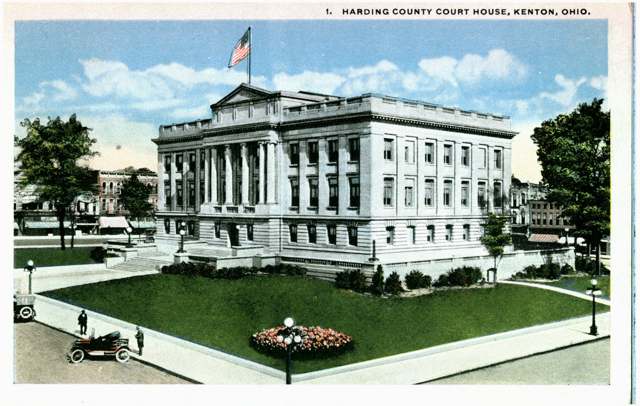
Photo: Columbus Metropolitan Library, via Digital Public Library of America / Ohio Digital Network, public domain · Wikimedia Commons
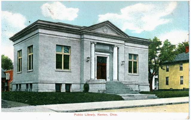
Photo: Columbus Metropolitan Library, via Digital Public Library of America / Ohio Digital Network, public domain · Wikimedia Commons
Local history sources: en.wikipedia.org · cityofkenton.com · hardincountyohio.gov · en.wikipedia.org · en.wikipedia.org · en.wikipedia.org · hmdb.org · en.wikipedia.org · remarkableohio.org · hmdb.org · commons.wikimedia.org · commons.wikimedia.org · commons.wikimedia.org
Historic places
2 places in Kenton on the National Register of Historic Places. Press a pin or a name for its whole record.
-
Hardin County CourthouseBuilding · Kenton · listed 1979
- Address
- Courthouse Sq.
- Where
- Kenton, Hardin County · ZIP 43326
- What it is
- Building
- Listed on the National Register
- 1979
- NRIS reference number
- 79001863
- Coordinates
- 40.64738, -83.60888
National Register file (NPS) ↗ Search Wikipedia ↗ Street map and directions ↗ On the Cracked Buckeye map
-
Kenton Public LibraryBuilding · Kenton · listed 1983
- Address
- 121 N. Detroit St.
- Where
- Kenton, Hardin County · ZIP 43326
- What it is
- Building
- Listed on the National Register
- 1983
- NRIS reference number
- 83004311
- Coordinates
- 40.64854, -83.60952
National Register file (NPS) ↗ Search Wikipedia ↗ Street map and directions ↗ On the Cracked Buckeye map
Source: National Park Service, National Register of Historic Places point file. The listing year is shown where NPS's certification date agrees with the listing's reference number. Listing recognizes significance; it does not restrict a private owner.
Water
Scioto River valley aquifer (local wells, low confidence) The water here
- Kenton City100% of residentsScioto River valley aquifer (local wells, low confidence)
Hospitals, fire stations and more
Inside Kenton's boundary: 1 hospital, 1 health center, 1 dialysis center, 1 nursing home, 1 fire or EMS station, 4 public schools, 1 private school, 1 poor-rated bridge, 1 library, 1 museum, 2 police stations, 6 Toxics Release Inventory facilities, 1 station or terminal and 5 spill cases. Press a pin or a name for its whole record and its source.
Hospitals (1)
-
Hardin Memorial HospitalGeneral hospital · Kenton
- What it is
- General hospital
- Address
- 921 E Franklin Street, Kenton, OH 43326
- County
- Hardin County
- Beds
- 25
- Helipad
- Yes
- Ownership
- Non-profit
- Medicare overall rating
- not rated
- Emergency department (Medicare)
- Yes
- Phone
- (419) 675-8139
- Medicare ID
- 361315
Medicare Care Compare ↗ Where HIFLD got this record ↗ HIFLD hospitals (source) ↗ Street map and directions ↗
Source: HIFLD hospitals inventory via FEMA (closed hospitals it still lists left out, hospitals opened since added), with Medicare Care Compare ratings matched by name and address.
Community health centers (1)
-
Kenton Community Health CenterHealth center · Kenton
- Run by
- a federally qualified health center
- Setting
- Clinic
- City
- Kenton
- Coordinates
- 40.64128, -83.60823
Find a Health Center (HRSA) ↗ HRSA data (source) ↗ Street map and directions ↗
Source: HRSA health center service delivery sites, active, September 2026 (school-based sites left out). Health centers see patients whether or not they have insurance, with fees on a sliding scale.
Dialysis centers (1)
-
Davita Kenton DialysisDialysis · Kenton
- Address
- 1207 E Columbus Street, Kenton, OH 43326
- Dialysis stations
- 10
- Medicare star rating
- 1 of 5 stars
- Services
- in-center hemodialysis, peritoneal dialysis, home hemodialysis training
- Ownership
- for profit
- Chain
- DaVita
- Medicare certified since
- 2013-12-10
- Phone
- (419) 675-4075
- Medicare ID
- 362805
Medicare Care Compare ↗ CMS dialysis facility list (source) ↗ Street map and directions ↗
Source: CMS dialysis facility list, September 2026, geocoded with the Census Bureau batch geocoder (an address it could not place sits at its ZIP center).
Nursing homes (1)
-
Kenton Nursing and Rehabilitation Center2 of 5 stars · Kenton
- Address
- 117 Jacob Parrott Boulevard, Kenton, OH 43326
- Certified beds
- 125
- Residents on an average day
- 89
- Medicare overall rating
- 2 of 5 stars
- Health inspections
- 2 of 5 stars
- Staffing
- 2 of 5 stars
- Quality measures
- 3 of 5 stars
- Penalties since 2023
- none
- Ownership
- For profit - Individual
- Chain
- AOM HEALTHCARE
- Takes
- Medicare and Medicaid
- Phone
- (419) 674-4197
- Medicare ID
- 365843
Medicare Care Compare ↗ CMS nursing home data (source) ↗ Street map and directions ↗
Source: CMS Care Compare nursing home provider and penalties files; Medicare star ratings run 1 to 5.
Fire and EMS stations (1)
-
Kenton Fire DepartmentKenton
- Address
- 225 South Main Street, Kenton, OH 43326
- Coordinates
- 40.64531, -83.60769
USGS National Map structures (source) ↗ Street map and directions ↗
Source: USGS National Map structures (most Ohio records last updated 2019 to 2022), checked against the Columbus and Cleveland station lists. The department that answers a call is set by jurisdiction and mutual aid, not by distance.
Public schools (4)
-
Hardin Community SchoolKenton
- Address
- 400 Decatur St, Kenton, OH 43326
- Kind (NCES)
- Regular School
- Students, 2023-24
- 34
- Teachers (full-time equivalent)
- 1
- NCES school ID
- 390142905652
-
Kenton Elementary School3 of 5 stars · Kenton
- Address
- 631 Silver Street, Kenton, OH 43326
- School district
- Kenton City School District
- Kind (NCES)
- Regular School
- Students, 2023-24
- 1,030
- Teachers (full-time equivalent)
- 65
- Report card, 2025-26
- 3 of 5 stars
- Performance index
- 74.9%
- Ohio building IRN
- 015131
- NCES school ID
- 391002501090
NCES school record ↗ Ohio School Report Card ↗ Street map and directions ↗
-
Kenton High School3 of 5 stars · Kenton
- Address
- 200 Harding Ave, Kenton, OH 43326
- School district
- Kenton City School District
- Kind (NCES)
- Regular School
- Students, 2023-24
- 547
- Teachers (full-time equivalent)
- 36
- Report card, 2025-26
- 3 of 5 stars
- Performance index
- 72.2%
- Four-year graduation rate
- 94.7%
- Ohio building IRN
- 018846
- NCES school ID
- 391002501091
NCES school record ↗ Ohio School Report Card ↗ Street map and directions ↗
-
Kenton Middle School2.5 of 5 stars · Kenton
- Address
- 300 Oriental St, Kenton, OH 43326
- School district
- Kenton City School District
- Kind (NCES)
- Regular School
- Students, 2023-24
- 266
- Teachers (full-time equivalent)
- 14
- Report card, 2025-26
- 2.5 of 5 stars
- Performance index
- 65.6%
- Ohio building IRN
- 018853
- NCES school ID
- 391002501092
NCES school record ↗ Ohio School Report Card ↗ Street map and directions ↗
Source: NCES EDGE public school locations 2024-25 and Common Core of Data 2023-24 (type, students, teachers); Ohio School Report Cards 2025-26 (Department of Education and Workforce), matched by name within the district.
Private schools (1)
-
Simon Kenton School/Hardin County Brd of DdPrivate, special education · Kenton
- Address
- 705 N Ida St, Kenton, OH 43326
- Kind
- special education
- Students, 2023-24
- 6
- Teachers (full-time equivalent)
- 1.1
- Students per teacher
- 5.45455
- Phone
- (937) 309-1343
- NCES private school ID
- A2103001
Source: NCES Private School Survey 2023-24.
Bridges rated poor (1)
-
Leighton Street over Scioto RiverPoor · built 1993
- Condition
- Poor: a deck, superstructure, substructure or culvert rated 4 or below on the 0 to 9 scale
- What it is
- Bridge
- Built
- 1993
- Length
- 47 ft
- Owner
- City
- Vehicles a day
- 1,463
- Coordinates
- 40.64416, -83.61347
National Bridge Inventory (source) ↗ Street map and directions ↗
Source: FHWA National Bridge Inventory 2025. "Poor" means one major part rated 4 or below on the 0 to 9 scale; it calls for repair, not closing, unless the state posts or closes the bridge.
Public libraries (1)
-
Mary Lou Johnson-Hardin Cnty PlCentral library · Kenton
- Address
- 325 E. Columbus St., Kenton, OH 44326
- What it is
- Central library
- Library system
- Mary Lou Johnson-Hardin Cnty Pl
- Open
- 3,120 hours a year, 52 weeks
- Building
- 18,000 sq ft
- System's visits, FY2024
- 54,808
- System's loans, FY2024
- 90,259
- People the system serves
- 11,458
- Phone
- (419) 673-2278
IMLS Public Libraries Survey (source) ↗ Street map and directions ↗
Source: IMLS Public Libraries Survey FY2024 (outlets and their systems). Any Ohio resident can get a free card at any Ohio public library.
Museums, historical societies, gardens and zoos (1)
-
Hardin County Historical MuseumsHistory museum · Kenton
- What it is
- History museum
- City
- Kenton
- Coordinates
- 40.64987, -83.60793
Search Wikipedia ↗ IMLS Museum Data Files (source) ↗ Street map and directions ↗
The museum list is IMLS's 2018 file; a museum may have closed or moved since.
Source: IMLS Museum Data Files, 2018.
Police stations (2)
-
Hardin County Sheriff's OfficeKenton
- Address
- 1025 South Main Street, Kenton, OH 43326
- Coordinates
- 40.63653, -83.60343
USGS National Map structures (source) ↗ Street map and directions ↗
-
Kenton Police DepartmentKenton
- Address
- 111 West Franklin Street, Kenton, OH 43326
- Coordinates
- 40.64697, -83.60852
USGS National Map structures (source) ↗ Street map and directions ↗
Source: USGS National Map structures, police stations, corrected and completed by hand (September 2026). The department that answers a call is set by jurisdiction, not by distance.
Facilities reporting toxic releases (6)
-
Andover IncToxics Release Inventory · Kenton
- Address
- 350 W Espy St, Kenton, OH 43326
- County
- Hardin County
- Status
- Reports to the Toxics Release Inventory (active)
- EPA program ID
- 43326NTDTC350WE
- EPA registry ID
- 110004597801
EPA facility record ↗ EPA Facility Registry Service (source) ↗ Street map and directions ↗
-
Chs Inc Kenton Lube PlantToxics Release Inventory · Kenton
- Address
- 728 Steiner Ave., Kenton, OH 43326
- County
- Hardin County
- Status
- Reports to the Toxics Release Inventory (active)
- EPA program ID
- 43326NVRSL728ST
- EPA registry ID
- 110001129458
EPA facility record ↗ EPA Facility Registry Service (source) ↗ Street map and directions ↗
-
Countrymark Inc Kenton Liquid PlantToxics Release Inventory · Kenton
- Address
- 14889 Bales Rd, Kenton, OH 43326
- County
- Hardin County
- Status
- Reports to the Toxics Release Inventory (active)
- EPA program ID
- 43326CNTRY14889
- EPA registry ID
- 110002109502
EPA facility record ↗ EPA Facility Registry Service (source) ↗ Street map and directions ↗
-
Graphic Packaging International, LlcToxics Release Inventory · Kenton
- Address
- 808 Fountain Street, Kenton, OH 43326
- County
- Hardin County
- Status
- Reports to the Toxics Release Inventory (active)
- EPA program ID
- 43326NTRNT88FNT
- EPA registry ID
- 110001627785
EPA facility record ↗ EPA Facility Registry Service (source) ↗ Street map and directions ↗
-
Kenton Iron Products IncToxics Release Inventory · Kenton
- Address
- 350 Vine St., Kenton, OH 43326
- County
- Hardin County
- Status
- Reports to the Toxics Release Inventory (active)
- EPA program ID
- 43326KNTNR350VI
- EPA registry ID
- 110000382988
EPA facility record ↗ EPA Facility Registry Service (source) ↗ Street map and directions ↗
-
King Ohio ForgeToxics Release Inventory · Kenton
- Address
- 820 Steiner Ave, Kenton, OH 43326
- County
- Hardin County
- Status
- Reports to the Toxics Release Inventory (closed)
- EPA program ID
- 43326BRDRC820ST
- EPA registry ID
- 110001627794
EPA facility record ↗ EPA Facility Registry Service (source) ↗ Street map and directions ↗
Source: EPA Facility Registry Service, Toxics Release Inventory reporters. Reporting a release is required of large users of listed chemicals; it is not by itself a violation.
Stations and terminals (1)
-
Marathon Gas StationIntercity bus stop · Greyhound Lines
- What it is
- Intercity bus stop
- Operator
- Greyhound Lines
- City
- Kenton
- Coordinates
- 40.64390, -83.60815
BTS Intermodal Passenger Connectivity Database (source) ↗ Street map and directions ↗
Source: BTS Intermodal Passenger Connectivity Database and National Transit Map (2025). Bus stops are counted on the card and drawn on the full map.
Spills reported since 2021 (5)
-
Oil Petroleum Not Otherwise Specified (Nos)2025-06-17 · Kenton
- Reported
- 2025-06-17
- What spilled
- Oil Petroleum Not Otherwise Specified (Nos)
- Largest amount reported
- 1 gallons
- Where
- Kenton, Hardin County
- Ohio EPA district office
- NWDO
- Ohio EPA case number
- 2506EPA0000996
Ohio EPA spill reports (source) ↗ Street map and directions ↗
-
Material White Reached water2025-04-24 · Kenton
- Reported
- 2025-04-24
- What spilled
- Material White
- Reached a waterway
- 33 - Scioto River
- Where
- Kenton, Hardin County
- Ohio EPA district office
- NWDO
- Ohio EPA case number
- 2504EPA0000627
Ohio EPA spill reports (source) ↗ Street map and directions ↗
-
Fuel Gasoline ( 25% Ethanol Not E85)2022-04-22 · Kenton
- Reported
- 2022-04-22
- What spilled
- Fuel Gasoline ( 25% Ethanol Not E85)
- Where
- Kenton, Hardin County
- Ohio EPA district office
- NWDO
- Ohio EPA case number
- 2204EPA0000559
Ohio EPA spill reports (source) ↗ Street map and directions ↗
-
Oil Hydraulic Fluid(S)2026-06-14 · Kenton
- Reported
- 2026-06-14
- What spilled
- Oil Hydraulic Fluid(S)
- Where
- Kenton, Hardin County
- Ohio EPA district office
- NWDO
- Ohio EPA case number
- 2606EPA0001055
Ohio EPA spill reports (source) ↗ Street map and directions ↗
-
Fuel Diesel / Diesel Fuel (Vehicle On Or Off Road)2026-05-17 · Kenton
- Reported
- 2026-05-17
- What spilled
- Fuel Diesel / Diesel Fuel (Vehicle On Or Off Road)
- Where
- Kenton, Hardin County
- Ohio EPA district office
- NWDO
- Ohio EPA case number
- 2605EPA0000826
Ohio EPA spill reports (source) ↗ Street map and directions ↗
Source: Ohio EPA emergency response spill reports, 2021 to September 2026, one point per case where Ohio EPA placed it. A report is what the caller or responder recorded; amounts are often blank or estimated.
Its ZIP codes
Each ZIP code that touches Kenton, with the share of its residents who live here and the same headline figures as the ZIP page.
| ZIP | Share | Water | Radon | Home value | Schools | Flood |
|---|---|---|---|---|---|---|
| 43326 Kenton | 60% | Scioto River valley aquifer (local wells, low confidence) | 4.2 pCi/L average radon | Median year built 1968 | Kenton City · 3 stars overall | 4.3% of residents in the 1% floodplain |
Local government
Who holds office in Kenton, how its elections and ballot issues came out, and the state auditor's record.
Elections for office
| Date | Office | Candidates and votes |
|---|---|---|
| 2021-11-02 | Ward 4 Council | Ray Lawrence (REP) 115, 100.0% |
| 2021-11-02 | Ward 3 Council | Antwilla Davis 202, 100.0% |
| 2021-11-02 | Ward 2 Council | David M. Beazley 361, 100.0% |
| 2021-11-02 | Ward 1 Council | Mary E. Burkett 168, 100.0% |
| 2021-11-02 | Treasurer | Terri L. Downey (REP) 989, 100.0% |
| 2021-11-02 | President of Council | Joel E. Althauser 946, 100.0% |
| 2021-11-02 | Council-at-Large | B.J. Hall 287, 9.92%; Robin Jones 850, 29.37%; Patricia A. Risner 353, 12.2%; Anda M. Tudor 586, 20.25%; Peggy Wren 818, 28.27% |
| 2019-11-05 | Ward 3 Council | Antwilla Davis (REP) 246, 100.0% |
| 2019-11-05 | Ward 2 Council | David M. Beazley (REP) 356, 100.0% |
| 2019-11-05 | Ward 1 Council | John P. McEntee (REP) 203, 100.0% |
| 2019-11-05 | President of Council | Joel E. Althauser 1,013, 100.0% |
| 2019-11-05 | Mayor | Joseph A. Hord (DEM) 181, 14.8%; Tim Leffler 173, 14.15%; Lynn Jones Webb (REP) 869, 71.05% |
| 2019-11-05 | Director of Law | John A. Schwemer 841, 100.0% |
| 2019-11-05 | Council-at-Large | B.J. Hall 194, 6.28%; Robin Jones 730, 23.65%; Patti Risner (REP) 734, 23.78%; Tom Taylor 643, 20.83%; Peggy Wren (REP) 786, 25.46% |
| 2019-11-05 | Auditor | Brian Hattery (REP) 1,015, 100.0% |
Winners in bold. Results from the county board of elections' official canvass unless marked.
Auditor of State record
- No fiscal caution, watch or emergency on the Auditor of State's lists.
- Financial Health Indicators (the Auditor of State's 17 measures; critical / cautionary / positive): 2020 0 / 2 / 13; 2021 0 / 0 / 15; 2022 0 / 1 / 14; 2023 0 / 1 / 14; 2024 0 / 2 / 13; 2025 1 / 2 / 11.
- Financial Audit, 2024, released 2026-01-27
- Financial Audit, 2023, released 2024-12-05
The county
Hardin County: 10 ZIP codes, 23 cities, villages and townships, 31,735 people.
Nearby places
Rain and snow
How much has actually fallen on Kenton, day by day, from 1893 to now. Daily totals, not averages.
- rain, last 30 days
- 1.00 in
- 2026-09-30 to 2026-10-29
- rain so far in 2026
- 41.6 in
- 8.7 in above normal for the date
- snow so far in 2026
- 15.3 in
- a normal year brings 27.3 in
- a normal year
- 38.6 in
- average of 30 years, 1991-2020
| Month | Rain (in) | Snow (in) | Days counted |
|---|---|---|---|
| October 2026 | 1.00 | — | 29 |
| September 2026 | 7.66 | — | 30 |
| August 2026 | 6.84 | — | 31 |
| July 2026 | 2.52 | — | 31 |
| June 2026 | 5.59 | — | 30 |
| May 2026 | 5.91 | — | 31 |
| April 2026 | 6.24 | — | 30 |
| March 2026 | 4.07 | 0.3 | 31 |
| February 2026 | 0.61 | 3.9 | 28 |
| January 2026 | 1.16 | 11.2 | 31 |
| December 2025 | 1.89 | 8.8 | 31 |
| November 2025 | 1.93 | 3.9 | 30 |
| Wettest year | 2011 — 56.5 in |
|---|---|
| Driest year | 1934 — 18.8 in |
| Snowiest year | 1895 — 84.4 in |
| Wettest day on record | 23 June 2016 — 4.15 in |
| Heaviest snowfall in a day | 23 December 2004 — 14.53 in |
| Deepest snow on the ground | 21 January 1978 — 17.01 in |
89% of these days are measurements from a gauge inside Kenton; the rest are estimated from the nearest gauges around it.
48,878 days of records, 1893-01-01 to 2026-10-29. Source: NOAA NCEI GHCN-Daily, 3,240 gauges in and around Ohio. A day is "gauged" when a gauge standing inside the boundary reported it, and the value is the mean of those gauges. Otherwise it is interpolated by inverse distance from every gauge reporting within 50 miles. Nothing is carried forward, back-filled or smoothed. Against NOAA nClimDiv county monthly precipitation over 136,848 complete county-months (checked 2026-10-31): correlation 0.9515, median absolute difference 0.217 in a month. Built 2026-10-31 from the Cracked Buckeye precipitation archive. Snow is the softer number — snowfall is measured by hand with a ruler, no agency publishes a gridded county snowfall series, and blowing snow defeats every observer.
Environmental permits and filings
What Ohio EPA has on file for Kenton: permits, inspections, violations, cleanups and the state loans behind sewer and water work. Every line links to the agency's own document.
- facilities and sites on file
- 67
- those placed on the map inside Kenton
| Program | Facilities and sites |
|---|---|
| Hazardous waste | 15 |
| State water loans | 14 |
| Wastewater and stormwater discharge | 10 |
| Voluntary cleanup | 8 |
| State sewer loans | 7 |
| Air pollution | 3 |
| Contaminated-site cleanup | 2 |
| Landfills | 2 |
| Public drinking water | 2 |
| Sewer and water-line construction | 2 |
| Composting | 1 |
| Municipal Solid Waste Transfer Facilities | 1 |
| Date | Facility or site | What |
|---|---|---|
| HARDIN COUNTY SOLID WASTE FACILITY | Municipal Solid Waste Transfer Facilities inspection | |
| HARDIN COUNTY SOLID WASTE FACILITY | Landfills inspection | |
| HARDIN COUNTY SOLID WASTE FACILITY | Landfills report | |
| KENTON CITY PWS | Public drinking water notice of violation | |
| KENTON WWTP | Wastewater and stormwater discharge inspection | |
| KENTON CITY PWS | State water loans | |
| HARDIN COUNTY SOLID WASTE FACILITY | Composting report | |
| KENTON WWTP | Wastewater and stormwater discharge report | |
| HARDIN COUNTY SOLID WASTE FACILITY | Landfills inspection | |
| KENTON CITY PWS | Public drinking water inspection | |
| KENTON CITY PWS | Public drinking water report | |
| KENTON CITY PWS | Public drinking water inspection | |
| GRAPHIC PACKAGING INTERNATIONAL LLC | Air pollution permit | |
| KENTON CITY PWS | Public drinking water violation resolved | |
| HARDIN COUNTY SOLID WASTE FACILITY | Landfills inspection | |
| HARDIN COUNTY SOLID WASTE FACILITY | Composting violation resolved | |
| HARDIN COUNTY SOLID WASTE FACILITY | Landfills report | |
| KENTON CITY PWS | Public drinking water inspection | |
| KENTON CITY PWS | State water loans | |
| HAR-67 SIDEWALKS IN KENTON | Wastewater and stormwater discharge permit | |
| HARDIN COUNTY SOLID WASTE FACILITY | Municipal Solid Waste Transfer Facilities report | |
| HARDIN COUNTY SOLID WASTE FACILITY | Landfills report | |
| HARDIN COUNTY SOLID WASTE FACILITY | Landfills report | |
| KENTON CITY PWS | State water loans | |
| GRAPHIC PACKAGING INTERNATIONAL LLC | Air pollution permit |
Source: Ohio EPA eDocument portal (edocpub.epa.ohio.gov), indexed 2026-10-14. Facilities are placed on the map from Ohio EPA's own map layers, EPA's Facility Registry, coordinates written in the filings, or a geocoded street address. A permit filed under a private person's name (most are household septic systems) is counted but never named, placed or linked; licenses for individual workers and open-burning notices are left out entirely.
Quick answers
What county is Kenton, Ohio in?
Kenton is a city in Hardin County, Ohio, with 7,947 residents.
When was Kenton, Ohio founded?
Kenton was settled 1812; laid out 1833; incorporated 1845 (village); 1886 (city). Founders on record: Ohio legislature/county commissioners, on the site of Fort McArthur. Source
How did Kenton, Ohio get its name?
Kenton was named for Simon Kenton (1755-1836), the Kentucky and Ohio frontiersman, scout, and Indian fighter who helped open the Ohio country to settlement; he was not a resident of the town but a figure the new county seat was named to honor. Source
What ZIP code is Kenton, Ohio?
Most of Kenton is in ZIP code 43326.
Where does Kenton, Ohio get its water?
The main water source for Kenton (Kenton City): Scioto River valley aquifer (local wells, low confidence).
Cite this page
Cite this page as:
Cracked Buckeye, "Kenton, Hardin County", https://crackedbuckeye.com/place/kenton/, built 2026-10-31, accessed [date].
How to cite · Report a correction · Built 2026-10-31
