Local events in Kelleys Island
Nothing is posted for Kelleys Island itself yet; here is what is on within 20 miles. All local events in Kelleys Island
Know a calendar we should watch? Send the link
Checked October 20; the events page is refreshed daily.
Deep dives about Kelleys Island
Long reads built from maps, newspapers and public records. All deep dives
- Fort Ancient and Serpent MoundOhio's Fort Ancient farmers built maize villages from about AD 1000-1650. Nearby, Serpent Mound's true age is still disputed: about 300 BC or AD 1070.
- Kelleys IslandKelleys Island, the largest American island in Lake Erie, was bought by Datus and Irad Kelley from 1833 and renamed in 1840. Its quarries employed 500 men by 1900.
- Ohio's deep timeOhio was once a tropical sea south of the Equator, home to giant trilobites and a toothless armored fish — and it has no dinosaur fossils at all.
- Ohio's Ice Age glaciersIce a mile thick once buried the Lake Erie basin. Three glaciations reshaped Ohio, rerouted its rivers, and left the farmland Ohioans still farm today.
How Kelleys Island began
Kelleys Island, the largest American island in Lake Erie, carried Native American names and occupants for centuries -- Algonquian and Iroquoian peoples, possibly including the Erie nation, fished from it until around 1656 -- before 18th-century maps called it Sandusky Island, an 1806 federal survey numbered it Island Number 6, and it was later known as Cunningham Island. Connecticut-born brothers Datus and Irad Kelley began buying land in 1833 and eventually owned the whole 3,000-acre island, renaming it for themselves in 1840 and building limestone quarrying, lime kilns and, from 1842, a grape and wine industry that by the early 1900s produced half a million gallons of wine a year. The island holds two of Ohio's most striking natural and cultural landmarks: Inscription Rock, a limestone slab carved with more than a hundred pre-Columbian petroglyphs on its south shore, and the Glacial Grooves, a 120-meter exposure of Devonian limestone scoured nine meters wide and four and a half meters deep by Ice Age glaciers.
Settled 1826 (first European American settlement); by 1656 for documented Native occupation, by Datus and Irad Kelley, who bought out the island's earlier landholders starting August 20, 1833.
Where the name comes from
Named for brothers Datus Kelley (born 1788) and Irad Kelley (born 1791), Connecticut natives who began purchasing land on the island in 1833 at $1.50 an acre and eventually owned all 3,000 acres, renaming it Kelleys Island in 1840. Earlier names included Sandusky Island (on late-18th-century maps), "Island Number 6" (an 1806 federal survey), and Cunningham Island.
Before the town
Algonquian and Iroquoian peoples, possibly including the Erie nation destroyed by the Iroquois in the Beaver Wars of the 1650s, fished from and occupied Kelleys Island until around 1656. The island's most direct physical evidence of that occupation is Inscription Rock, a limestone slab on the south shore carved with more than 100 images in a style similar to Haudenosaunee (Iroquois) petroglyphs in Canada; because the soft limestone erodes quickly, researchers generally believe the carvings are less than 1,000 years old. The Kelleys Island Historical Association has relied on an investigation by ethnologist Henry Rowe Schoolcraft dating the carvings to roughly 1643, and local tradition holds the people responsible for them were killed by Iroquois nations around 1665 -- a date that lines up closely with the documented destruction of the Erie people between about 1650 and 1656. A companion petroglyph once on the island's north shore, carved into granite, was destroyed by quarry workers who dynamited it; it no longer exists.
Nations recorded here: Erie (possible), Haudenosaunee (Iroquois).
- Inscription Rock (other) — south shore of Kelleys Island, c. 1643 (Schoolcraft dating) to 1665 (tradition) (en.wikipedia.org)
- North shore petroglyph (destroyed) (other) — north shore of Kelleys Island, dynamited by quarry workers, pre-1900s (destroyed) (en.wikipedia.org)
Timeline
- — The petroglyphs at Inscription Rock were carved, according to Schoolcraft's investigation and local tradition, by Native people later said to have been killed by Iroquois nations around 1665.
- — Documented Native American occupation of the island, by Algonquian and Iroquoian peoples possibly including the Erie nation, ended around this time.
- — A federal survey designated the island "Island Number 6"; it was later known as Cunningham Island.
- — The island's west shore served as a military rendezvous point under General William Henry Harrison during the War of 1812.
- — European American settlement of the island began.
- — John Clemons opened the island's first limestone quarry; six families lived on the island.
- — Brothers Datus and Irad Kelley began purchasing island land at $1.50 an acre.
- — Inscription Rock was found partially buried in sand.
- — The Kelley brothers, now owners of the entire 3,000-acre island, renamed it Kelleys Island; the population was 68.
- — Charles Carpenter began the island's grape-growing industry.
- — Colonel Eastman of the U.S. Army made detailed drawings of Inscription Rock's carvings, which he submitted to Shingwauk, a Native American with pictographic expertise, for interpretation.
- — The island was producing about 500,000 gallons of wine a year.
- — The Estes Schoolhouse was built for $15,000.
- — Inscription Rock was listed on the National Register of Historic Places.
- — 23 acres on the island's south shore were designated a historic district and listed on the National Register.
- — The historic district was renamed the Kelleys Island Historic District and expanded to cover the entire island.
Stories
A carved rock and a nation that vanished from Ohio
When settlers found Inscription Rock half-buried in the sand of Kelleys Island's south shore in 1833, they had uncovered more than a hundred images carved into soft limestone -- figures resembling the pictographic style of the Haudenosaunee (Iroquois) of Canada. In 1851 the Army sent Colonel Eastman to make careful drawings of the carvings, which he then handed to Shingwauk, a Native man versed in pictographic reading, for interpretation; decades later, ethnologist Henry Rowe Schoolcraft's investigation dated the carvings to around 1643. Local tradition holds that the people who carved them were killed by Iroquois nations around 1665 -- a date that fits closely with the documented destruction of the Erie confederacy, an Iroquoian-speaking people whose homeland lay along Lake Erie's south shore, in a series of Iroquois campaigns between about 1650 and 1656. Whether or not Inscription Rock's carvers were Erie themselves, Kelleys Island's own Wikipedia entry notes that Algonquian and Iroquoian peoples, possibly including the Erie, used the island until around 1656 -- meaning the rock likely records one of the last Native communities to occupy Ohio's Lake Erie shore before the Beaver Wars emptied the region of resident towns for nearly half a century. A second, granite petroglyph once stood on the island's north shore; quarry workers dynamited it sometime before the 20th century, and it survives today only in memory.
Two brothers buy an island
Datus Kelley, born in Connecticut in 1788, and his younger brother Irad, born in 1791, began buying up parcels of what was then called Cunningham Island in August 1833, paying $1.50 an acre. Within a few years they owned the entire 3,000-acre island and, in 1840, renamed it for themselves. Under Kelley ownership the island built sixteen limestone kilns, expanded its docks to ship out lime, fruit and red cedar lumber, and drew seasonal immigrant labor from Ireland, Poland, Eastern Europe and Italy to work the quarries. Charles Carpenter's 1842 grapevines turned into a second major industry, and by the early 1900s the island -- with a year-round population that had reached over 1,100 by 1900 -- was producing roughly half a million gallons of wine annually, a scale of production remarkable for a piece of land barely four and a half square miles in size.
Photographs
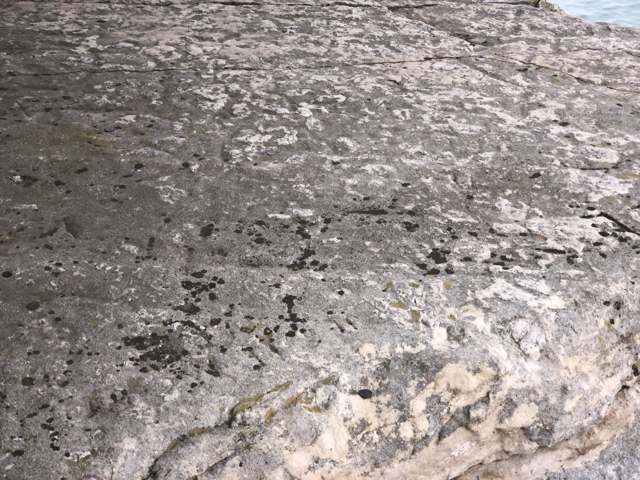
Photo: Mbrickn, via Wikimedia Commons, CC BY 4.0 · Wikimedia Commons
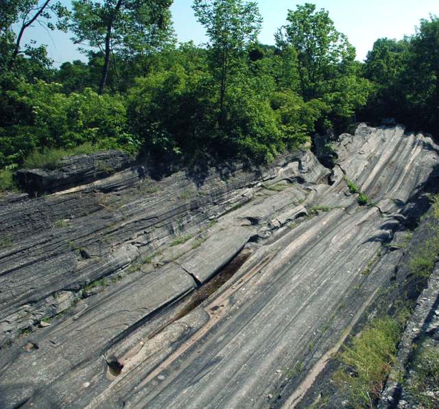
Photo: James St. John, via Wikimedia Commons, CC BY 2.0 · Wikimedia Commons
Local history sources: en.wikipedia.org · en.wikipedia.org · commons.wikimedia.org · commons.wikimedia.org
Historic places
2 places in Kelleys Island on the National Register of Historic Places. Press a pin or a name for its whole record.
-
Beatty, Louis, HouseBuilding · Kelleys Island · listed 1984
- Address
- South Shore Dr.
- Where
- Kelleys Island, Erie County · ZIP 43438
- What it is
- Building
- Listed on the National Register
- 1984
- NRIS reference number
- 84000106
- Coordinates
- 41.59495, -82.69762
National Register file (NPS) ↗ Search Wikipedia ↗ Street map and directions ↗ On the Cracked Buckeye map
-
Inscription RockObject · Kelleys Island · listed 1973
- Address
- Kelleys Island
- Where
- Kelleys Island, Erie County · ZIP 43438
- What it is
- Object
- Listed on the National Register
- 1973
- NRIS reference number
- 73001432
- Coordinates
- 41.59284, -82.70698
National Register file (NPS) ↗ Search Wikipedia ↗ Street map and directions ↗ On the Cracked Buckeye map
Source: National Park Service, National Register of Historic Places point file. The listing year is shown where NPS's certification date agrees with the listing's reference number. Listing recognizes significance; it does not restrict a private owner.
Water
Lake Erie The water here
- Kelleys Island Village100% of residentsLake Erie
Hospitals, fire stations and more
Inside Kelleys Island's boundary: 1 health center, 1 fire or EMS station, 2 public schools, 1 library, 1 museum, 1 police station, 1 station or terminal and 1 spill case. Press a pin or a name for its whole record and its source.
Community health centers (1)
-
KI Addison RoadHealth center · Kelleys Island
- Run by
- a federally qualified health center
- Setting
- Clinic
- City
- Kelleys Island
- Coordinates
- 41.59400, -82.70628
Find a Health Center (HRSA) ↗ HRSA data (source) ↗ Street map and directions ↗
Source: HRSA health center service delivery sites, active, September 2026 (school-based sites left out). Health centers see patients whether or not they have insurance, with fees on a sliding scale.
Fire and EMS stations (1)
-
Kelleys Island Fire DepartmentKelleys Island
- Address
- 121 Addison Road, Kelleys Island, OH 43438
- Coordinates
- 41.59457, -82.70619
USGS National Map structures (source) ↗ Street map and directions ↗
Source: USGS National Map structures (most Ohio records last updated 2019 to 2022), checked against the Columbus and Cleveland station lists. The department that answers a call is set by jurisdiction and mutual aid, not by distance.
Public schools (2)
-
Kelleys Island Elementary SchoolKelleys Island
- Address
- 528 Division St, Kelleys Island, OH 43438
- Kind (NCES)
- Regular School
- Students, 2023-24
- 0
- NCES school ID
- 390467910837
-
Kelleys Island High SchoolKelleys Island
- Address
- 528 Division St, Kelleys Island, OH 43438
- Kind (NCES)
- Regular School
- Students, 2023-24
- 7
- NCES school ID
- 390467904270
Source: NCES EDGE public school locations 2024-25 and Common Core of Data 2023-24 (type, students, teachers); Ohio School Report Cards 2025-26 (Department of Education and Workforce), matched by name within the district.
Public libraries (1)
-
Kelleys Island BranchBranch · Kelleys Island
- Address
- 528 Division St, Kelleys Island, OH 43438
- What it is
- Branch
- Library system
- Sandusky Library
- Open
- 352 hours a year, 35 weeks
- Building
- 3,500 sq ft
- System's visits, FY2024
- 110,760
- System's loans, FY2024
- 434,673
- People the system serves
- 44,878
- Phone
- (419) 746-2356
IMLS Public Libraries Survey (source) ↗ Street map and directions ↗
Source: IMLS Public Libraries Survey FY2024 (outlets and their systems). Any Ohio resident can get a free card at any Ohio public library.
Museums, historical societies, gardens and zoos (1)
-
Kelleys Island Historical AssociationHistorical society · Kelleys Island
- What it is
- Historical society
- City
- Kelleys Island
- Coordinates
- 41.59593, -82.72286
Search Wikipedia ↗ IMLS Museum Data Files (source) ↗ Street map and directions ↗
The museum list is IMLS's 2018 file; a museum may have closed or moved since.
Source: IMLS Museum Data Files, 2018.
Police stations (1)
-
Kelleys Island Police DepartmentKelleys Island
- Address
- 122 Division Street, Kelleys Island, OH 43438
- Coordinates
- 41.59478, -82.71060
USGS National Map structures (source) ↗ Street map and directions ↗
Source: USGS National Map structures, police stations, corrected and completed by hand (September 2026). The department that answers a call is set by jurisdiction, not by distance.
Stations and terminals (1)
-
Seaway MarinaFerry terminal · Kelleys Island
- What it is
- Ferry terminal
- City
- Kelleys Island
- Coordinates
- 41.59512, -82.72548
BTS Intermodal Passenger Connectivity Database (source) ↗ Street map and directions ↗
Source: BTS Intermodal Passenger Connectivity Database and National Transit Map (2025). Bus stops are counted on the card and drawn on the full map.
Spills reported since 2021 (1)
-
Sheen Rainbow / Hydrocarbon2024-09-22 · Kelleys Island
- Reported
- 2024-09-22
- What spilled
- Sheen Rainbow / Hydrocarbon
- Where
- Kelleys Island, Ottawa County
- Ohio EPA district office
- NWDO
- Ohio EPA case number
- 2409EPA0001622
Ohio EPA spill reports (source) ↗ Street map and directions ↗
Source: Ohio EPA emergency response spill reports, 2021 to September 2026, one point per case where Ohio EPA placed it. A report is what the caller or responder recorded; amounts are often blank or estimated.
Its ZIP codes
Each ZIP code that touches Kelleys Island, with the share of its residents who live here and the same headline figures as the ZIP page.
| ZIP | Share | Water | Radon | Home value | Schools | Flood |
|---|---|---|---|---|---|---|
| 43438 Kelleys Island | 100% | Lake Erie | 2.5 pCi/L average radon | Median year built 1988 | Kelleys Island Local · No 2025-26 report card | 23% of residents in the 1% floodplain |
Local government
Who holds office in Kelleys Island, how its elections and ballot issues came out, and the state auditor's record.
Money issues on the ballot since 2017: 6 of 8 passed; of those asking for new or higher taxes, 0 of 2.
Ballot issues
| Date | Issue | For | Against | Result |
|---|---|---|---|---|
| 2022-11-08 | Issue 10: Issue 10 Kelleys Island Village - Renewal Levy, Current Operating Expenses, 1.25 mills (1.25 mills, renewal) | 171 | 57 | Passed (75.0% for), unofficial |
| 2021-11-02 | 11: 11 Proposed Tax Levy (Renewal) - Kelleys Island Village (Current Expenses, 1.75 mills) (1.75 mills, renewal) | 184 | 52 | Passed (77.97% for) |
| 2021-11-02 | 12: 12 Proposed Tax Levy (Renewal with an Increase) - Kelleys Island Village (Emergency | 177 | 62 | Passed (74.06% for) |
| 2021-11-02 | 13: 13 Proposed Tax Levy (Additional) - Kelleys Island Village (Police, 0.36 mill) (0.36 mills, additional) | 119 | 120 | Failed (49.79% for) |
| 2019-11-05 | 16: 16 Kelleys Island Village Referendum (Clerk/Treasurer) | 36 | 154 | Failed (18.95% for) |
| 2019-11-05 | 17: 17 Kelleys Island Village Tax Levy (Fire, Ambulance, EMS) | 165 | 18 | Passed (90.16% for) |
| 2019-11-05 | 18: 18 Kelleys Island Village Tax Levy (Roads) | 157 | 26 | Passed (85.79% for) |
| 2017-11-07 | 9: #9 Kelleys Island Village Tax Levy Additional Police Protection | 114 | 126 | Failed (47.5% for) |
| 2017-11-07 | 10: #10 Kelleys Island Village Tax Levy Renewal Emergency Medical Services | 204 | 38 | Passed (84.3% for) |
Elections for office
| Date | Office | Candidates and votes |
|---|---|---|
| 2021-11-02 | Member of Council | Max Eaton 128, 16.52%; Mary Gaither 160, 20.65%; Eric Longbrake 105, 13.55%; Greg Ritchie 107, 13.81%; Scot A. Smith 118, 15.23%; Joe Wolfe 157, 20.26% |
| 2019-11-05 | Member of Council | Gary Finger 135, 45.61%; R. Russell Maust, III 161, 54.39% |
| 2019-11-05 | Mayor | Ronald E. Ehrbar 155, 100.0% |
| 2019-11-05 | Clerk-Treasurer | Rosalyn L. Ahner 18, 9.63%; Lisa M. Klonaris 169, 90.37% |
Winners in bold. Results from the county board of elections' official canvass unless marked.
Auditor of State record
- No fiscal caution, watch or emergency on the Auditor of State's lists.
- Agreed Upon Procedures, 2023 to 2024, released 2026-02-24
The county
Erie County: 7 ZIP codes, 15 cities, villages and townships, 78,997 people.
Nearby places
No nearby place shares a ZIP code with Kelleys Island in the atlas yet.
Rain and snow
How much has actually fallen on Kelleys Island, day by day, from 1893 to now. Daily totals, not averages.
- rain, last 30 days
- 1.73 in
- 2026-09-29 to 2026-10-28
- rain so far in 2026
- 35.1 in
- 4.8 in above normal for the date
- snow so far in 2026
- 16.1 in
- a normal year brings 26.4 in
- a normal year
- 35.4 in
- average of 30 years, 1991-2020
| Month | Rain (in) | Snow (in) | Days counted |
|---|---|---|---|
| October 2026 | 1.73 | — | 28 |
| September 2026 | 2.64 | — | 30 |
| August 2026 | 5.57 | — | 31 |
| July 2026 | 5.10 | — | 31 |
| June 2026 | 4.78 | — | 30 |
| May 2026 | 4.17 | — | 31 |
| April 2026 | 5.91 | — | 30 |
| March 2026 | 3.98 | 0.0 | 31 |
| February 2026 | 0.36 | 1.8 | 28 |
| January 2026 | 0.91 | 14.2 | 31 |
| December 2025 | 1.79 | 3.6 | 31 |
| November 2025 | 1.33 | 1.0 | 30 |
| Wettest year | 2011 — 58.1 in |
|---|---|
| Driest year | 1934 — 18.9 in |
| Snowiest year | 1910 — 68.7 in |
| Wettest day on record | 24 August 2023 — 5.20 in |
| Heaviest snowfall in a day | 14 February 2007 — 14.02 in |
| Deepest snow on the ground | 1 February 1978 — 21.03 in |
Estimated, not measured. No rain gauge has ever stood inside Kelleys Island, so every figure here is worked out from the gauges around it - the nearest ones weighted most. Treat them as close estimates rather than readings.
48,695 days of records, 1893-04-01 to 2026-10-28. Source: NOAA NCEI GHCN-Daily, 3,240 gauges in and around Ohio. A day is "gauged" when a gauge standing inside the boundary reported it, and the value is the mean of those gauges. Otherwise it is interpolated by inverse distance from every gauge reporting within 50 miles. Nothing is carried forward, back-filled or smoothed. Against NOAA nClimDiv county monthly precipitation over 136,848 complete county-months (checked 2026-10-31): correlation 0.9515, median absolute difference 0.217 in a month. Built 2026-10-31 from the Cracked Buckeye precipitation archive. Snow is the softer number — snowfall is measured by hand with a ruler, no agency publishes a gridded county snowfall series, and blowing snow defeats every observer.
Environmental permits and filings
What Ohio EPA has on file for Kelleys Island: permits, inspections, violations, cleanups and the state loans behind sewer and water work. Every line links to the agency's own document.
- facilities and sites on file
- 6
- those placed on the map inside Kelleys Island
| Program | Facilities and sites |
|---|---|
| Wastewater and stormwater discharge | 2 |
| Municipal Solid Waste Transfer Facilities | 1 |
| Public drinking water | 1 |
| Sewer and water-line construction | 1 |
| State water loans | 1 |
| Date | Facility or site | What |
|---|---|---|
| CAMP PATMOS PWS | Public drinking water notice of violation | |
| SCG KI 103 VALERIE TRAIL PROPERTY LLC | Wastewater and stormwater discharge permit | |
| SCG KI 103 VALERIE TRAIL PROPERTY LLC | Wastewater and stormwater discharge permit | |
| CAMP PATMOS PWS | Public drinking water inspection | |
| CAMP PATMOS PWS | Public drinking water report | |
| KELLEYS ISLAND TRANSFER FACILITY | Municipal Solid Waste Transfer Facilities report | |
| KELLEYS ISLAND TRANSFER FACILITY | Municipal Solid Waste Transfer Facilities permit | |
| KELLEYS ISLAND TRANSFER FACILITY | Municipal Solid Waste Transfer Facilities inspection | |
| CAMP PATMOS PWS | Public drinking water inspection | |
| CAMP PATMOS PWS | Public drinking water compliance letter | |
| KELLEYS ISLAND TRANSFER FACILITY | Municipal Solid Waste Transfer Facilities permit | |
| KELLEYS ISLAND TRANSFER FACILITY | Municipal Solid Waste Transfer Facilities permit | |
| CAMP PATMOS PWS | Public drinking water inspection | |
| KELLEYS ISLAND TRANSFER FACILITY | Municipal Solid Waste Transfer Facilities inspection | |
| CAMP PATMOS PWS | Public drinking water notice of violation | |
| VILLAGE OF KELLEYS ISLAND | Sewer and water-line construction permit | |
| CAMP PATMOS PWS | Public drinking water inspection | |
| CAMP PATMOS PWS | Public drinking water inspection | |
| CAMP PATMOS PWS | Public drinking water inspection | |
| CAMP PATMOS PWS | Public drinking water inspection | |
| CAMP PATMOS PWS | Public drinking water notice of violation | |
| CAMP PATMOS PWS | Public drinking water monitoring results | |
| CAMP PATMOS PWS | Public drinking water inspection | |
| CAMP PATMOS PWS | Public drinking water report | |
| KELLEYS ISLAND TRANSFER FACILITY | Municipal Solid Waste Transfer Facilities report |
Source: Ohio EPA eDocument portal (edocpub.epa.ohio.gov), indexed 2026-10-14. Facilities are placed on the map from Ohio EPA's own map layers, EPA's Facility Registry, coordinates written in the filings, or a geocoded street address. A permit filed under a private person's name (most are household septic systems) is counted but never named, placed or linked; licenses for individual workers and open-burning notices are left out entirely.
Quick answers
What county is Kelleys Island, Ohio in?
Kelleys Island is a village in Erie County, Ohio, with 256 residents.
When was Kelleys Island, Ohio founded?
Kelleys Island was settled 1826 (first European American settlement); by 1656 for documented Native occupation. Founders on record: Datus and Irad Kelley, who bought out the island's earlier landholders starting August 20, 1833. Source
How did Kelleys Island, Ohio get its name?
Named for brothers Datus Kelley (born 1788) and Irad Kelley (born 1791), Connecticut natives who began purchasing land on the island in 1833 at $1.50 an acre and eventually owned all 3,000 acres, renaming it Kelleys Island in 1840. Source
What ZIP code is Kelleys Island, Ohio?
Most of Kelleys Island is in ZIP code 43438.
Where does Kelleys Island, Ohio get its water?
The main water source for Kelleys Island (Kelleys Island Village): Lake Erie.
Cite this page
Cite this page as:
Cracked Buckeye, "Kelleys Island, Erie County", https://crackedbuckeye.com/place/kelleys-island/, built 2026-10-31, accessed [date].
How to cite · Report a correction · Built 2026-10-31
