Local events in Jamestown
20 events in the next 90 days from 1 public calendar. All local events in Jamestown
Checked October 20; the events page is refreshed daily.
How Jamestown began
Jamestown was surveyed in 1815 by Thomas P. Moorman and a Clinton County surveyor named Thomas, on land originally owned by Thomas Browder and Martin Mendenhall, then platted and recorded in 1816. It was named for James Browder, an early pioneer settler, and by tradition also echoes Jamestown, Virginia, the ancestral home of one of the first settlers. Straddling Silvercreek and Ross townships in eastern Greene County, it grew into a farming trade center known for its fairgrounds and, after a destructive 1884 cyclone, rebuilt itself around Washington and Limestone streets. Today it is a village of about 2,050 people anchored by its restored 1889 Opera House.
Settled 1815 (surveyed), platted 1816, by Thomas P. Moorman, surveyor; land owned by Thomas Browder and Martin Mendenhall.
Where the name comes from
County historians differ on the fine point: the 1908 county history says the village was named for James Browder, an early pioneer farmer on whose land it was laid out; a modern summary instead ties the name to Jamestown, Virginia, as the native home of one of the first settlers. Both point to the same Browder family origin.
Before the town
No village, camp, mound or trail specific to the Jamestown site itself turned up in the sources checked. The surrounding Silvercreek and Ross townships have no recorded Native American sites either; the nearest documented Shawnee towns (Old Chillicothe/Oldtown and the Mad River village near present Xenia and Yellow Springs) lie roughly 15 to 20 miles west.
Nations recorded here: Shawnee.
Timeline
- — Thomas P. Moorman and the Clinton County surveyor Thomas survey the townsite on land held by Thomas Browder and Martin Mendenhall.
- — Jamestown is platted and recorded, named for James Browder.
- — The Jamestown Fair begins; it later grows large enough to rival the Ohio State Fair before eventually closing.
- — Civil War veteran and Jamestown hardware merchant Albert Wickersham, back in Silvercreek Township since his 1864 discharge, builds his house on Washington Street across from the newly built Methodist church.
- — A cyclone in the spring destroys roughly a third of the town.
- — The Jamestown Opera House is built at 19 N. Limestone Street, designed by architect John W. McLean with Matthew Moorman & Sons; over its life it also serves as village hall, fire station, post office and library.
- — The Jamestown Opera House is listed on the National Register of Historic Places.
- — The Wickersham House is listed on the National Register of Historic Places.
Stories
The house Wickersham built
Albert Wickersham grew up in Silver Creek Township and came home to Jamestown after his Union Army discharge in June 1864. He built a hardware and agricultural implement business into a solid success, and about a decade later, in 1876, put up a house on Washington Street that showed it: a prominent lot a block from the commercial downtown, directly across from the town's newly built Methodist church. The house still stands as one of the village's clearest markers of a Civil War veteran turned local businessman making good, and it went on the National Register in 2018.
A town rebuilt after the storm, and a fair that rivaled the state's
In the spring of 1884 a cyclone tore through Jamestown and flattened roughly a third of the buildings in town. The village rebuilt, and within a few decades its economy leaned on two pillars: the farm trade that had always supported it, and the Jamestown Fair, started in 1860, which grew popular enough at its peak to rival the Ohio State Fair before it eventually closed. The 1889 Opera House, built downtown not long after the storm, became the town's civic anchor, doubling over the years as its village hall, fire station, post office and library before its restoration and 2007 National Register listing.
Photographs
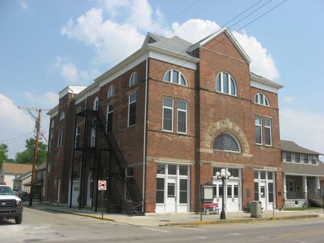
Photo: Nyttend, public domain · Wikimedia Commons
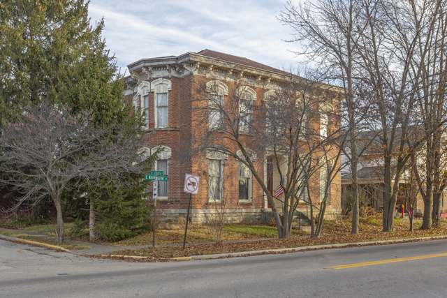
Photo: Christopher L. Riley, CC BY-SA 4.0 · Wikimedia Commons
Local history sources: ohiogenealogyexpress.com · en.wikipedia.org · en.wikipedia.org · hmdb.org · en.wikipedia.org · commons.wikimedia.org · commons.wikimedia.org
Historic places
2 places in Jamestown on the National Register of Historic Places. Press a pin or a name for its whole record.
-
Jamestown Opera HouseBuilding · Jamestown · listed 2007
- Address
- 19 N. Limestone St.
- Where
- Jamestown, Greene County · ZIP 45335
- What it is
- Building
- Listed on the National Register
- 2007
- NRIS reference number
- 07001093
- Coordinates
- 39.65903, -83.73451
National Register file (NPS) ↗ Search Wikipedia ↗ Street map and directions ↗ On the Cracked Buckeye map
-
Wickersham HouseBuilding · Jamestown
- Address
- 23 E Washington St.
- Where
- Jamestown, Greene County · ZIP 45335
- What it is
- Building
- Latest NPS certification action
- 2018
- NRIS reference number
- 100003208
- Coordinates
- 39.65631, -83.73354
National Register file (NPS) ↗ Search Wikipedia ↗ Street map and directions ↗ On the Cracked Buckeye map
Source: National Park Service, National Register of Historic Places point file. The listing year is shown where NPS's certification date agrees with the listing's reference number. Listing recognizes significance; it does not restrict a private owner.
Water
Mostly private wells The water here
- Jamestown Village99% of residentsGroundwater wells (3 wells)
- Western Water Company1% of residentsLittle Miami River valley wells (51%) plus Cincinnati Ohio River water (49%)
Hospitals, fire stations and more
Inside Jamestown's boundary: 1 fire or EMS station, 3 public schools, 1 poor-rated bridge, 1 library, 1 police station and 2 spill cases. Press a pin or a name for its whole record and its source.
Fire and EMS stations (1)
-
Silvercreek Township Fire DepartmentJamestown
- Address
- 28 East Xenia Street, Jamestown, OH 45335
- Coordinates
- 39.65876, -83.73182
USGS National Map structures (source) ↗ Street map and directions ↗
Source: USGS National Map structures (most Ohio records last updated 2019 to 2022), checked against the Columbus and Cleveland station lists. The department that answers a call is set by jurisdiction and mutual aid, not by distance.
Public schools (3)
-
Greeneview Elementary School3.5 of 5 stars · Jamestown
- Address
- 53 N Limestone St, Jamestown, OH 45335
- School district
- Greeneview Local School District
- Kind (NCES)
- Regular School
- Students, 2023-24
- 417
- Teachers (full-time equivalent)
- 24
- Report card, 2025-26
- 3.5 of 5 stars
- Performance index
- 83.6%
- Ohio building IRN
- 145987
- NCES school ID
- 390472604616
NCES school record ↗ Ohio School Report Card ↗ Street map and directions ↗
-
Greeneview High School3.5 of 5 stars · Jamestown
- Address
- 4710 Cottonville Rd, Jamestown, OH 45335
- School district
- Greeneview Local School District
- Kind (NCES)
- Regular School
- Students, 2023-24
- 411
- Teachers (full-time equivalent)
- 27
- Report card, 2025-26
- 3.5 of 5 stars
- Performance index
- 78.3%
- Four-year graduation rate
- 97.9%
- Ohio building IRN
- 014498
- NCES school ID
- 390472602822
NCES school record ↗ Ohio School Report Card ↗ Street map and directions ↗
-
Greeneview Middle School3.5 of 5 stars · Jamestown
- Address
- 4990 Cottonville Rd, Jamestown, OH 45335
- School district
- Greeneview Local School District
- Kind (NCES)
- Regular School
- Students, 2023-24
- 428
- Teachers (full-time equivalent)
- 25
- Report card, 2025-26
- 3.5 of 5 stars
- Performance index
- 82%
- Ohio building IRN
- 014480
- NCES school ID
- 390472602823
NCES school record ↗ Ohio School Report Card ↗ Street map and directions ↗
Source: NCES EDGE public school locations 2024-25 and Common Core of Data 2023-24 (type, students, teachers); Ohio School Report Cards 2025-26 (Department of Education and Workforce), matched by name within the district.
Bridges rated poor (1)
-
SR 72 over Caesar CreekPoor · built 1954
- Condition
- Poor: a deck, superstructure, substructure or culvert rated 4 or below on the 0 to 9 scale
- What it is
- Bridge
- Built
- 1954
- Length
- 18 ft
- Owner
- State
- Vehicles a day
- 4,311
- Coordinates
- 39.66089, -83.73467
National Bridge Inventory (source) ↗ Street map and directions ↗
Source: FHWA National Bridge Inventory 2025. "Poor" means one major part rated 4 or below on the 0 to 9 scale; it calls for repair, not closing, unless the state posts or closes the bridge.
Public libraries (1)
-
Jamestown Branch LibraryBranch · Jamestown
- Address
- 86 Seaman Dr, Jamestown, OH 45335
- What it is
- Branch
- Library system
- Greene County Public Library
- Open
- 2,860 hours a year, 52 weeks
- Building
- 4,000 sq ft
- System's visits, FY2024
- 427,596
- System's loans, FY2024
- 2,831,847
- People the system serves
- 167,966
- Phone
- (937) 352-4005
IMLS Public Libraries Survey (source) ↗ Street map and directions ↗
Source: IMLS Public Libraries Survey FY2024 (outlets and their systems). Any Ohio resident can get a free card at any Ohio public library.
Police stations (1)
-
Jamestown Police DepartmentJamestown
- Address
- 84 Seaman Drive, Jamestown, OH 45335
- Coordinates
- 39.65805, -83.74385
USGS National Map structures (source) ↗ Street map and directions ↗
Source: USGS National Map structures, police stations, corrected and completed by hand (September 2026). The department that answers a call is set by jurisdiction, not by distance.
Spills reported since 2021 (2)
-
Sewage Human2024-08-22 · Jamestown
- Reported
- 2024-08-22
- What spilled
- Sewage Human
- Where
- Jamestown, Greene County
- Ohio EPA district office
- SWDO
- Ohio EPA case number
- 2408EPA0001448
Ohio EPA spill reports (source) ↗ Street map and directions ↗
-
Material Unknown2026-08-06 · Jamestown
- Reported
- 2026-08-06
- What spilled
- Material Unknown
- Where
- Jamestown, Greene County
- Ohio EPA district office
- SWDO
- Ohio EPA case number
- 2608EPA0001433
Ohio EPA spill reports (source) ↗ Street map and directions ↗
Source: Ohio EPA emergency response spill reports, 2021 to September 2026, one point per case where Ohio EPA placed it. A report is what the caller or responder recorded; amounts are often blank or estimated.
Its ZIP codes
Each ZIP code that touches Jamestown, with the share of its residents who live here and the same headline figures as the ZIP page.
| ZIP | Share | Water | Radon | Home value | Schools | Flood |
|---|---|---|---|---|---|---|
| 45335 Jamestown | 29% | Mostly private wells | 3.7 pCi/L average radon | Median year built 1972 | Greeneview Local · 3.5 stars overall | 10% of residents in the 1% floodplain |
Local government
How its elections and ballot issues came out and the state auditor's record.
Money issues on the ballot since 2019: 4 of 4 passed.
Ballot issues
| Date | Issue | For | Against | Result |
|---|---|---|---|---|
| 2025-05-06 | Issue 3: 3 Proposed Tax Levy (Renewal) Village of Jamestown | 91 | 60 | Passed (60.26% for) |
| 2021-11-02 | Issue: Jamestown Village Streets-Roads-Bridges Tax Levy #14 (levy type not on the results report) | 205 | 145 | Passed (58.57% for) |
| 2021-11-02 | Issue: Jamestown Village Police Tax Levy #15 (levy type not on the results report) | 250 | 101 | Passed (71.23% for) |
| 2020-03-17 | Issue: Village of Jamestown Renewal #2 | 248 | 92 | Passed (72.94% for) |
| 2019-11-05 | Issue: Jamestown Village Police Tax Levy #10 | 259 | 109 | Passed (70.38% for) |
| 2019-05-07 | Issue: 9 Jamestown Vlg Police Add 1.8M (1.8 mills) | 67 | 73 | Failed (47.86% for) |
| 2017-11-07 | Issue: 5 - Village of Jamestown- Renewal - Streets Total | 227 | 103 | Passed (68.79% for) |
Elections for office
| Date | Office | Candidates and votes |
|---|---|---|
| 2021-11-02 | Member of Council | Joel Armlovich 204, 19.79%; Kyle Calhoun 177, 17.17%; Anita S. Chaney 242, 23.47%; Jonathan Crosswhite 234, 22.7%; Lefonda Sue McDaniel 174, 16.88% |
| 2019-11-05 | Mayor | Joshua Bradley 300, 100.0% |
| 2019-11-05 | Council | Joel Armlovich 145, 23.89%; Herbert Crosswhite 235, 38.71%; Jonathan D. Smith 227, 37.4% |
| 2019-11-05 | Board of Public Affairs | R. Michael Helling 276, 100.0% |
| 2017-11-07 | Council | Joel A. Armlovich 101, 9.48%; Anita S. Chaney 193, 18.12%; Leslie E. Cox 150, 14.08%; Jonathan Crosswhite 156, 14.65%; Brian Gale 78, 7.32%; Jeannie Sargent 182, 17.09%; Jeffrey Tudor 114, 10.7%; Michael L. Williams 91, 8.54% |
| 2017-11-07 | Board of Public Affairs | Rick Cook 216, 49.32%; Bob Roach 222, 50.68% |
Winners in bold. Results from the county board of elections' official canvass unless marked. The county's results on file run through 2025-05-06; later elections are not loaded yet.
Auditor of State record
- No fiscal caution, watch or emergency on the Auditor of State's lists.
- Financial Audit, 2023 to 2024, released 2026-07-21
On the November 3, 2026 ballot
Statewide question: State Issue 3: Voter ID
Local questions for Jamestown, Greene County and its school district:
- Greene County: Renews a 0.25-mill property tax levy for the bridges of Greene County for 5 years, beginning in 2026.
Races, candidates and every question for an address: your ballot. County offices and judges are on your county board's sample ballot.
The county
Greene County: 17 ZIP codes, 23 cities, villages and townships with pages here, 174,322 people (Census Bureau estimate, July 2025).
Nearby places
Rain and snow
How much has actually fallen on Jamestown, day by day, from 1893 to now. Daily totals, not averages.
- rain, last 30 days
- 0.77 in
- 2026-10-01 to 2026-10-30
- rain so far in 2026
- 45.0 in
- 8.1 in above normal for the date
- snow so far in 2026
- 19.7 in
- a normal year brings 22.4 in
- a normal year
- 43.3 in
- average of 30 years, 1991-2020
| Month | Rain (in) | Snow (in) | Days counted |
|---|---|---|---|
| October 2026 | 0.77 | — | 30 |
| September 2026 | 6.36 | — | 30 |
| August 2026 | 8.79 | — | 31 |
| July 2026 | 2.81 | — | 31 |
| June 2026 | 3.77 | — | 30 |
| May 2026 | 7.45 | — | 31 |
| April 2026 | 3.91 | — | 30 |
| March 2026 | 7.18 | 0.8 | 31 |
| February 2026 | 2.60 | 5.5 | 28 |
| January 2026 | 1.34 | 13.4 | 31 |
| December 2025 | 2.60 | 10.1 | 31 |
| November 2025 | 2.87 | 3.7 | 30 |
| Wettest year (estimated) | 2011 — 59.7 in |
|---|---|
| Driest year (estimated) | 1930 — 25.0 in |
| Snowiest year (estimated) | 1917 — 54.4 in |
| Wettest day (estimated) | 4 July 1975 — 4.10 in |
| Heaviest snowfall in a day (estimated) | 26 November 1950 — 14.04 in |
| Deepest snow on the ground (estimated) | 24 January 1918 — 22.01 in |
Estimated, not measured. No rain gauge has ever stood inside Jamestown, so every figure here is worked out from the gauges around it - the nearest ones weighted most. Treat them as close estimates rather than readings.
47,689 days of records, 1893-01-01 to 2026-10-30. Source: NOAA NCEI GHCN-Daily, 3,240 gauges in and around Ohio. A day is "gauged" when a gauge standing inside the boundary reported it, and the value is the mean of those gauges. Otherwise it is interpolated by inverse distance from every gauge reporting within 50 miles. Nothing is carried forward, back-filled or smoothed. Against NOAA nClimDiv county monthly precipitation over 136,848 complete county-months (checked 2026-11-01): correlation 0.9515, median absolute difference 0.217 in a month. Built 2026-11-01 from the Cracked Buckeye precipitation archive. Snow is the softer number — snowfall is measured by hand with a ruler, no agency publishes a gridded county snowfall series, and blowing snow defeats every observer.
Environmental permits and filings
What Ohio EPA has on file for Jamestown: permits, inspections, violations, cleanups and the state loans behind sewer and water work. Every line links to the agency's own document.
- facilities and sites on file
- 7
- those placed on the map inside Jamestown
| Program | Facilities and sites |
|---|---|
| Air pollution | 2 |
| Hazardous waste | 2 |
| Public drinking water | 1 |
| Sewer and water-line construction | 1 |
| Source-water protection | 1 |
| Date | Facility or site | What |
|---|---|---|
| JAMESTOWN VILLAGE PWS | Public drinking water plan | |
| JAMESTOWN VILLAGE PWS | Public drinking water compliance letter | |
| JAMESTOWN VILLAGE PWS | Public drinking water inspection | |
| JAMESTOWN VILLAGE PWS | Public drinking water compliance letter | |
| TWIST INC PLT 2 | Air pollution report | |
| JAMESTOWN VILLAGE PWS | Public drinking water plan | |
| JAMESTOWN VILLAGE PWS | Public drinking water inspection | |
| JAMESTOWN VILLAGE PWS | Public drinking water compliance letter | |
| JAMESTOWN VILLAGE PWS | Public drinking water plan | |
| JAMESTOWN VILLAGE PWS | Public drinking water inspection | |
| JAMESTOWN VILLAGE PWS | Public drinking water inspection | |
| JAMESTOWN VILLAGE PWS | Public drinking water compliance letter | |
| JAMESTOWN VILLAGE PWS | Public drinking water plan | |
| JAMESTOWN VILLAGE PWS | Public drinking water inspection | |
| JAMESTOWN VILLAGE PWS | Public drinking water plan | |
| JAMESTOWN VILLAGE PWS | Public drinking water notice of violation | |
| JAMESTOWN VILLAGE PWS | Public drinking water inspection | |
| JAMESTOWN VILLAGE PWS | Public drinking water compliance letter | |
| JAMESTOWN VILLAGE PWS | Public drinking water inspection | |
| JAMESTOWN VILLAGE PWS | Public drinking water compliance letter | |
| JAMESTOWN VILLAGE PWS | Public drinking water warning letter | |
| JAMESTOWN VILLAGE PWS | Public drinking water compliance letter | |
| TWIST INC PLT 2 | Hazardous waste compliance letter | |
| JAMESTOWN VILLAGE PWS | Public drinking water compliance letter | |
| JAMESTOWN VILLAGE PWS | Public drinking water violation resolved |
Source: Ohio EPA eDocument portal (edocpub.epa.ohio.gov), indexed 2026-10-14. Facilities are placed on the map from Ohio EPA's own map layers, EPA's Facility Registry, coordinates written in the filings, or a geocoded street address. A permit filed under a private person's name (most are household septic systems) is counted but never named, placed or linked; licenses for individual workers and open-burning notices are left out entirely.
Quick answers
What county is Jamestown, Ohio in?
Jamestown is a village in Greene County, Ohio, with 2,052 residents.
When was Jamestown, Ohio founded?
Jamestown was settled 1815 (surveyed); laid out 1816. Founders on record: Thomas P. Moorman, surveyor; land owned by Thomas Browder and Martin Mendenhall. Source
How did Jamestown, Ohio get its name?
County historians differ on the fine point: the 1908 county history says the village was named for James Browder, an early pioneer farmer on whose land it was laid out; a modern summary instead ties the name to Jamestown, Virginia, as the native home of one of the first settlers. Source
What ZIP code is Jamestown, Ohio?
Most of Jamestown is in ZIP code 45335.
Where does Jamestown, Ohio get its water?
The main water source for Jamestown (Jamestown Village): Mostly private wells.
Cite this page
Cite this page as:
Cracked Buckeye, "Jamestown, Greene County", https://crackedbuckeye.com/place/jamestown/, built 2026-10-31, accessed [date].
How to cite · Report a correction · Built 2026-10-31