Local events in Hiram
11 events in the next 90 days from 2 public calendars. All local events in Hiram
Checked October 20; the events page is refreshed daily.
Notable people from Hiram
Ohioans tied to this place, each with a sourced profile. All notable Ohioans
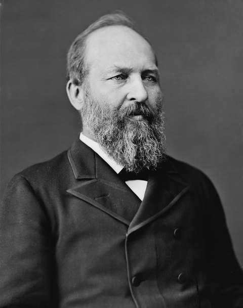

History from Hiram
People and inventions tied to this place, each with its sources. All people · All inventions
Videos about Hiram
Short videos we made from the old maps and records. All videos

How Hiram began
Hiram village was formed from portions of Hiram Township, home to Hiram College (founded 1850 as the Western Reserve Eclectic Institute); its post office was established in 1816. Future president James A. Garfield lived in the village from 1863 to 1876 while teaching at, then representing Ohio's 19th congressional district after leaving, the institute; his wife Lucretia later served as First Lady from March to September 1881, and sons Harry and James Rudolph both went on to prominent careers in education and government. The village's population has fluctuated sharply, from 144 in 1880 to a peak of 1,484 in 1970. Today, part of the Akron metropolitan area, it has 996 residents (2020).
Incorporated Formed from portions of Hiram Township.
Where the name comes from
Takes its name from the surrounding Hiram Township, itself named for Hiram I, the biblical king of Tyre.
Before the town
No Native American village, camp or mound site specific to the village of Hiram is documented in the sources consulted; Cayuga people are recorded camping near the Nelson Ledges close to the township.
Timeline
- — The Hiram post office is established.
- — The Western Reserve Eclectic Institute, later Hiram College, is founded in the village.
- — James A. Garfield, who had taught at and led the institute, resides in the village while serving in Congress.
- — The village's population stands at 144 residents.
- — Lucretia Garfield, whose family had lived in Hiram, serves as First Lady of the United States from March to September, following her husband's assassination that September.
- — The village's population reaches 659.
- — The village's population peaks at 1,484.
Stories
A president's village home
Before he was a general, a congressman or a president, James A. Garfield was a teacher and then the head of the Western Reserve Eclectic Institute in Hiram, and it was there, in the village itself, that he made his home from 1863 to 1876 while representing Ohio's 19th congressional district in Washington. His wife Lucretia shared that Hiram life with him, and their sons Harry and James Rudolph, raised partly in the village, both went on to substantial careers of their own — Harry eventually serving as president of Williams College, James Rudolph in federal government. When Garfield was assassinated in 1881 after less than a year as president, Lucretia's brief tenure as First Lady, from March to September that year, closed a chapter that had begun in this small Portage County village two decades earlier. Garfield's later, more famous home, Lawnfield, was built in Mentor, Ohio, not in Hiram — the village's claim on his story is this earlier, formative period.
Local history sources: en.wikipedia.org · en.wikipedia.org · en.wikipedia.org · en.wikipedia.org
Historic places
2 places in Hiram on the National Register of Historic Places. Press a pin or a name for its whole record.
-
Garfield, James A., HouseBuilding · Hiram
- Address
- 6825 Hinsdale St.
- Where
- Hiram, Portage County · ZIP 44234
- What it is
- Building
- Latest NPS certification action
- 1975
- NRIS reference number
- 09000098
- Coordinates
- 41.31295, -81.14545
National Register file (NPS) ↗ Search Wikipedia ↗ Street map and directions ↗ On the Cracked Buckeye map
-
Young, Thomas F., HouseBuilding · Hiram · listed 1976
- Address
- Wakefield and Garfield Sts.
- Where
- Hiram, Portage County · ZIP 44234
- What it is
- Building
- Listed on the National Register
- 1976
- NRIS reference number
- 76001511
- Coordinates
- 41.30971, -81.14425
National Register file (NPS) ↗ Search Wikipedia ↗ Street map and directions ↗ On the Cracked Buckeye map
Source: National Park Service, National Register of Historic Places point file. The listing year is shown where NPS's certification date agrees with the listing's reference number. Listing recognizes significance; it does not restrict a private owner.
Water
Mostly private wells The water here
- Hiram Village78% of residentsGroundwater wells (1 wells)
- Troy Oaks Homes13% of residentsGroundwater wells (6 wells)
- Nelson Ledges Estates MHP5% of residentsGroundwater wells (3 wells)
- Inn At the Pines Alf & Mc3% of residentsGroundwater wells (1 wells)
Hospitals, fire stations and more
Inside Hiram's boundary: 1 fire or EMS station, 1 college, 1 police station, 1 Toxics Release Inventory facility and 3 spill cases. Press a pin or a name for its whole record and its source.
Fire and EMS stations (1)
-
Hiram Fire DepartmentHiram
- Address
- 11617 Garfield Road, Hiram, OH 44234
- Coordinates
- 41.30832, -81.14521
USGS National Map structures (source) ↗ Street map and directions ↗
Source: USGS National Map structures (most Ohio records last updated 2019 to 2022), checked against the Columbus and Cleveland station lists. The department that answers a call is set by jurisdiction and mutual aid, not by distance.
Colleges (1)
-
Hiram CollegePrivate nonprofit college · Hiram
- What it is
- Private nonprofit college
- City
- Hiram
- Students, 2023-24 (12-month count)
- 1,049
- Tuition and fees, in state
- $26,265
- Graduation rate
- 59% of bachelor's students, within six years (a class of 257)
- IPEDS unit ID
- 203128
College Navigator (NCES) ↗ IPEDS data (source) ↗ Street map and directions ↗
Source: NCES IPEDS 2024 directory, 2023-24 enrollment and tuition, graduation rates for the 2017 (four-year) and 2020 (two-year) entering classes.
Police stations (1)
-
Hiram Police DepartmentHiram
- Address
- 11617 Garfield Road, Hiram, OH 44234
- Coordinates
- 41.30836, -81.14501
USGS National Map structures (source) ↗ Street map and directions ↗
Source: USGS National Map structures, police stations, corrected and completed by hand (September 2026). The department that answers a call is set by jurisdiction, not by distance.
Facilities reporting toxic releases (1)
-
Mantaline CorporationToxics Release Inventory · Hiram
- Address
- 6969 Constance Ave., Hiram, OH 44234
- County
- Portage County
- Status
- Reports to the Toxics Release Inventory (active)
- EPA program ID
- 44234PRTCH6969C
- EPA registry ID
- 110000388660
EPA facility record ↗ EPA Facility Registry Service (source) ↗ Street map and directions ↗
Source: EPA Facility Registry Service, Toxics Release Inventory reporters. Reporting a release is required of large users of listed chemicals; it is not by itself a violation.
Spills reported since 2021 (3)
-
Sludge (Non-Sewage)2025-02-12 · Hiram
- Reported
- 2025-02-12
- What spilled
- Sludge (Non-Sewage)
- Where
- Hiram, Portage County
- Ohio EPA district office
- NEDO
- Ohio EPA case number
- 2502EPA0000182
Ohio EPA spill reports (source) ↗ Street map and directions ↗
-
Sewage Human2023-06-06 · Hiram
- Reported
- 2023-06-06
- What spilled
- Sewage Human
- Where
- Hiram, Portage County
- Ohio EPA district office
- NEDO
- Ohio EPA case number
- 2306EPA0000931
Ohio EPA spill reports (source) ↗ Street map and directions ↗
-
Fat(S) / Oil / Grease / Tallow Food Types (Fog) Reached water2022-07-29 · Hiram
- Reported
- 2022-07-29
- What spilled
- Fat(S) / Oil / Grease / Tallow Food Types (Fog)
- Reached a waterway
- 67 - Eagle Creek
- Where
- Hiram, Portage County
- Ohio EPA district office
- NEDO
- Ohio EPA case number
- 2207EPA0001150
Ohio EPA spill reports (source) ↗ Street map and directions ↗
Source: Ohio EPA emergency response spill reports, 2021 to September 2026, one point per case where Ohio EPA placed it. A report is what the caller or responder recorded; amounts are often blank or estimated.
Its ZIP codes
Each ZIP code that touches Hiram, with the share of its residents who live here and the same headline figures as the ZIP page.
| ZIP | Share | Water | Radon | Home value | Schools | Flood |
|---|---|---|---|---|---|---|
| 44234 Hiram Township and Hiram | 26% | Mostly private wells | 3.5 pCi/L average radon | Parcel list only | Crestwood Local · 4 stars overall | 2.3% of residents in the 1% floodplain |
Local government
Who holds office in Hiram, how its elections and ballot issues came out, and the state auditor's record.
Auditor of State record
- No fiscal caution, watch or emergency on the Auditor of State's lists.
- Financial Audit, 2022 to 2023, released 2026-02-24
The county
Portage County: 15 ZIP codes, 29 cities, villages and townships, 169,745 people.
Nearby places
Rain and snow
How much has actually fallen on Hiram, day by day, from 1893 to now. Daily totals, not averages.
- rain, last 30 days
- 1.38 in
- 2026-09-30 to 2026-10-29
- rain so far in 2026
- 41.0 in
- 3.2 in above normal for the date
- snow so far in 2026
- 52.0 in
- a normal year brings 66.2 in
- a normal year
- 44.8 in
- average of 30 years, 1991-2020
| Month | Rain (in) | Snow (in) | Days counted |
|---|---|---|---|
| October 2026 | 1.38 | — | 29 |
| September 2026 | 4.14 | — | 30 |
| August 2026 | 6.20 | — | 31 |
| July 2026 | 4.94 | — | 31 |
| June 2026 | 1.71 | — | 30 |
| May 2026 | 5.95 | 1.0 | 31 |
| April 2026 | 7.79 | — | 30 |
| March 2026 | 4.74 | 4.2 | 31 |
| February 2026 | 1.17 | 9.2 | 28 |
| January 2026 | 2.95 | 37.5 | 31 |
| December 2025 | 2.94 | 24.8 | 31 |
| November 2025 | 2.79 | 19.3 | 30 |
| Wettest year | 2011 — 67.5 in |
|---|---|
| Driest year | 1953 — 25.6 in |
| Snowiest year | 2010 — 111.5 in |
| Wettest day on record | 14 September 1979 — 5.53 in |
| Heaviest snowfall in a day | 9 November 1913 — 17.01 in |
| Deepest snow on the ground | 26 November 1950 — 22.01 in |
Almost every day here is a measurement: 97% of them come from a rain gauge standing inside Hiram itself.
48,878 days of records, 1893-01-01 to 2026-10-29. Source: NOAA NCEI GHCN-Daily, 3,240 gauges in and around Ohio. A day is "gauged" when a gauge standing inside the boundary reported it, and the value is the mean of those gauges. Otherwise it is interpolated by inverse distance from every gauge reporting within 50 miles. Nothing is carried forward, back-filled or smoothed. Against NOAA nClimDiv county monthly precipitation over 136,848 complete county-months (checked 2026-10-31): correlation 0.9515, median absolute difference 0.217 in a month. Built 2026-10-31 from the Cracked Buckeye precipitation archive. Snow is the softer number — snowfall is measured by hand with a ruler, no agency publishes a gridded county snowfall series, and blowing snow defeats every observer.
Environmental permits and filings
What Ohio EPA has on file for Hiram: permits, inspections, violations, cleanups and the state loans behind sewer and water work. Every line links to the agency's own document.
- facilities and sites on file
- 9
- those placed on the map inside Hiram
| Program | Facilities and sites |
|---|---|
| Hazardous waste | 4 |
| State water loans | 2 |
| Composting | 1 |
| Public drinking water | 1 |
| Site assessment | 1 |
| Date | Facility or site | What |
|---|---|---|
| HIRAM VILLAGE PWS | Public drinking water compliance letter | |
| HIRAM VILLAGE PWS | Public drinking water report | |
| HIRAM VILLAGE PWS | Public drinking water notice of violation | |
| HIRAM VILLAGE PWS | Public drinking water letter | |
| HIRAM VILLAGE PWS | Public drinking water plan | |
| HIRAM VILLAGE PWS | Public drinking water compliance letter | |
| HIRAM VILLAGE PWS | Public drinking water notice of violation | |
| HIRAM VILLAGE PWS | Public drinking water inspection | |
| HIRAM VILLAGE PWS | Public drinking water notice of violation | |
| HIRAM VILLAGE PWS | Public drinking water report | |
| HIRAM VILLAGE PWS | Public drinking water notice of violation | |
| HIRAM VILLAGE PWS | Public drinking water inspection | |
| HIRAM VILLAGE PWS | Public drinking water report | |
| HIRAM VILLAGE PWS | Public drinking water compliance letter | |
| HIRAM VILLAGE PWS | Public drinking water compliance letter | |
| MANTALINE CORPORATION | Hazardous waste compliance letter | |
| HIRAM VILLAGE PWS | Public drinking water inspection | |
| HIRAM VILLAGE PWS | Public drinking water compliance letter | |
| HIRAM VILLAGE PWS | Public drinking water inspection | |
| HIRAM VILLAGE PWS | Public drinking water compliance letter | |
| HIRAM VILLAGE PWS | Public drinking water inspection | |
| HIRAM VILLAGE PWS | Public drinking water compliance letter | |
| HIRAM VILLAGE PWS | Public drinking water report | |
| HIRAM VILLAGE PWS | Public drinking water notice of violation | |
| HIRAM VILLAGE | Composting inspection |
Source: Ohio EPA eDocument portal (edocpub.epa.ohio.gov), indexed 2026-10-14. Facilities are placed on the map from Ohio EPA's own map layers, EPA's Facility Registry, coordinates written in the filings, or a geocoded street address. A permit filed under a private person's name (most are household septic systems) is counted but never named, placed or linked; licenses for individual workers and open-burning notices are left out entirely.
Quick answers
What county is Hiram, Ohio in?
Hiram is a village in Portage County, Ohio, with 996 residents.
When was Hiram, Ohio founded?
Hiram was incorporated Formed from portions of Hiram Township. Source
How did Hiram, Ohio get its name?
Takes its name from the surrounding Hiram Township, itself named for Hiram I, the biblical king of Tyre. Source
What ZIP code is Hiram, Ohio?
Most of Hiram is in ZIP code 44234.
Where does Hiram, Ohio get its water?
The main water source for Hiram (Hiram Village): Mostly private wells.
Cite this page
Cite this page as:
Cracked Buckeye, "Hiram, Portage County", https://crackedbuckeye.com/place/hiram/, built 2026-10-31, accessed [date].
How to cite · Report a correction · Built 2026-10-31
