Gnadenhutten
Village · Tuscarawas County · 1,233 residents · 1.5% municipal income tax
Local events in Gnadenhutten
Gnadenhutten itself has 1 event posted in the next 90 days; the others here are within 20 miles. All local events in Gnadenhutten
Checked October 20; the events page is refreshed daily.
Deep dives about Gnadenhutten
Long reads built from maps, newspapers and public records. All deep dives
History from Gnadenhutten
People and inventions tied to this place, each with its sources. All people · All inventions
How Gnadenhutten began
Gnadenhutten, on the Tuscarawas River south of New Philadelphia, was founded in October 1772 as a Moravian mission town of German missionaries and Christian Lenape (Delaware) and Mohican converts — one of the oldest continuously documented Euro-American-founded settlements in Ohio. It grew to about 200 residents by 1775 under the Christian Mohican chief Joshua before the Revolutionary War made the mission's professed neutrality impossible to sustain. On March 8, 1782, Pennsylvania militia killed 96 unarmed Lenape and Mohican men, women and children who had returned to the abandoned town to gather their harvest, then burned the settlement — one of the most notorious atrocities of the frontier war. The site has been marked and memorialized since 1872, and the modern village, ZIP 44629, had 1,240 residents at the 2020 census.
Settled October 1772, by Moravian missionaries (led by David Zeisberger) and Lenape (Delaware) converts, under the Christian Mohican chief Joshua.
Where the name comes from
Gnadenhutten is German for "tents of grace" (also rendered "huts of grace"), the name the Moravian missionaries gave the settlement when they founded it in October 1772 as their second mission town on the Tuscarawas River, downstream from Schoenbrunn.
Before the town
Gnadenhutten was a Christian Lenape (Delaware) and Mohican (Munsee/Mahican) mission town, founded October 1772 as converts of Moravian missionary David Zeisberger settled alongside Schoenbrunn a few miles upstream. Under the Christian Mohican chieftain Joshua (who died August 1, 1773), the town grew to roughly 200 residents by 1775, with about 60 log cabins. During the Revolutionary War the town's Lenape and Mohican residents tried to remain neutral, which left them distrusted by both American militia and British-allied Wyandot and Shawnee. In September 1781 British-allied warriors forcibly relocated most of the mission population to the Sandusky River. In early March 1782 a group of roughly 150 Lenape and Mohican returned to Gnadenhutten and the nearby mission towns to harvest corn left standing in the fields. A Pennsylvania militia column found them there, disarmed them under false pretenses, and on March 8, 1782 killed 96 of them — bound and struck down with mallets and hatchets in two mission buildings — then burned the town's approximately 60 cabins. Only two boys escaped. As partial indemnity, three tracts of 4,000 acres each were later reserved for the Lenape near the mission towns, though the Lenape relinquished title to them in 1823 and the land passed to settlers regardless. No organized Native community remained at Gnadenhutten after that.
Nations recorded here: Lenape (Delaware), Christian Mohican (Munsee/Mahican converts).
- Gnadenhutten Massacre Site (other) — village of Gnadenhutten, south of downtown on a county road, on the Tuscarawas River, founded October 1772; massacre March 8, 1782 (en.wikipedia.org)
- Mass grave of the massacre victims (burial) — Gnadenhutten Historical Park, on the massacre site, 1782 burial; marked since (commons.wikimedia.org)
Timeline
- — Moravian missionaries and Lenape converts, led by David Zeisberger, found Gnadenhutten ("tents of grace") in October, on the Tuscarawas River downstream from Schoenbrunn, under the Christian Mohican chief Joshua.
- — Chief Joshua, the Christian Mohican leader of the settlement, dies on August 1.
- — The town's population reaches about 200 residents.
- — In September, British-allied warriors forcibly relocate most of the mission Indian population from the Tuscarawas towns to the Sandusky River, suspecting them of aiding the Americans.
- — On March 8, Pennsylvania militia under Lieutenant Colonel David Williamson kill 96 unarmed Lenape and Mohican men, women and children who had returned to harvest corn, then burn the town's roughly 60 cabins; only two boys escape.
- — Missionary John Heckewelder builds the first European-American house at the site of Gnadenhutten as resettlement of the valley resumes.
- — The Lenape relinquish title to the three 4,000-acre tracts that had been reserved near the mission towns as indemnity for the massacre.
- — The Ohio and Erie Canal is built through Gnadenhutten, giving the village a route to market.
- — A monument to the massacre victims is dedicated at the village centennial on June 5.
- — A flood destroys the Ohio and Erie Canal at Gnadenhutten; it is never rebuilt.
- — A museum is established at the Gnadenhutten Historical Park.
- — A peace tree is dedicated at the massacre site.
- — The State of Ohio erects a memorial marker at the site calling the killings a "day of shame."
Stories
A morning in the fields, and what followed
By the winter of 1781-82 the Christian Lenape and Mohican of Gnadenhutten had been forced off their land, moved north to the Sandusky by warriors allied with the British who no longer trusted the mission Indians' neutrality. Their corn still stood unharvested in the fields at Gnadenhutten, and in early March 1782 roughly 150 of them walked back south to gather it before it spoiled. A column of about 160 Pennsylvania militiamen, hunting for the raiders responsible for recent attacks on frontier settlements, found them there. The militia told the Lenape and Mohican they would be taken to Fort Pitt for their own safety, disarmed them, and held a vote among themselves on what to do next. On the morning of March 8, 1782, the militia bound their prisoners and killed 96 of them — men, women and children — with mallets and hatchets inside two mission buildings, then burned the town's roughly 60 cabins to the ground. Two boys survived to tell what had happened. The killings, against a community that had taken no part in the war, discredited the American cause among Ohio's Native nations for years afterward.
Marking the ground, a century and more later
Ohio did not memorialize what happened at Gnadenhutten quickly. It took ninety years, until the village's 1872 centennial, for a monument to go up on the massacre ground, and the state did not add its own marker calling the killings a "day of shame" until 2003 — 221 years after the fact. In between, a museum opened at the site in 1963 to hold what could be gathered of the mission's history, and in 1988 a peace tree was planted there. Three tracts of land, 4,000 acres each, had been set aside near the ruined towns in the years after the massacre as a kind of indemnity to the Lenape, but the Lenape gave up title to that land in 1823 and it passed into the hands of settlers regardless. The mass grave of the ninety-six still lies at Gnadenhutten Historical Park, on the same ground where the mission buildings burned.
Photographs

Photo: Henry Howe (1816-1893), CC0 · Wikimedia Commons
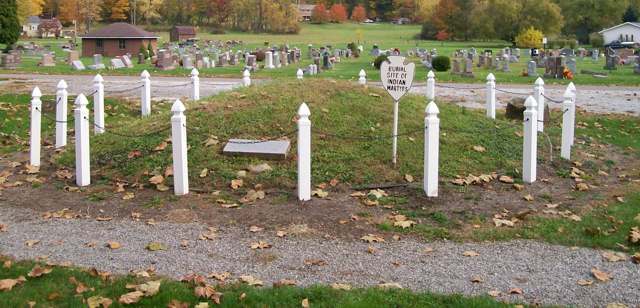
Photo: Wikimedia Commons contributor, 2009, CC BY 4.0 · Wikimedia Commons
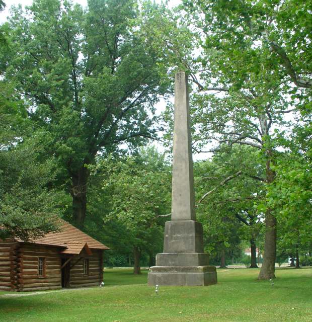
Photo: Kevin Myers, uploaded to Wikimedia Commons, public domain · Wikimedia Commons
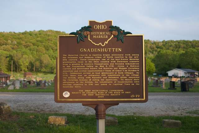
Photo: Flickr user "Michael" (34301961@N04), transferred to Commons, CC BY 2.0 · Wikimedia Commons
Local history sources: en.wikipedia.org · en.wikipedia.org · en.wikipedia.org · commons.wikimedia.org · commons.wikimedia.org · commons.wikimedia.org · commons.wikimedia.org
Historic places
1 place in Gnadenhutten on the National Register of Historic Places. Press a pin or a name for its whole record.
-
Gnadenhutten Massacre SiteSite · Gnadenhutten · listed 1970
- Address
- S of Gnadenhutten on county rte.
- Where
- Gnadenhutten, Tuscarawas County · ZIP 44629
- What it is
- Site
- Listed on the National Register
- 1970
- NRIS reference number
- 70000519
- Coordinates
- 40.35435, -81.43496
National Register file (NPS) ↗ Search Wikipedia ↗ Street map and directions ↗ On the Cracked Buckeye map
Source: National Park Service, National Register of Historic Places point file. The listing year is shown where NPS's certification date agrees with the listing's reference number. Listing recognizes significance; it does not restrict a private owner.
Water
Groundwater wells (2 wells) The water here
- Gnadenhutten96% of residentsGroundwater wells (2 wells)
- Tuscarawas Village4% of residentsGroundwater wells (2 wells)
Hospitals, fire stations and more
Inside Gnadenhutten's boundary: 1 fire or EMS station, 1 public school, 1 library, 1 museum, 1 police station, 1 Superfund site, 4 Toxics Release Inventory facilities and 4 spill cases. Press a pin or a name for its whole record and its source.
Fire and EMS stations (1)
-
Arrowhead Joint Fire DistrictGnadenhutten
- Address
- 131 South Walnut Street, Gnadenhutten, OH 44629
- Coordinates
- 40.35825, -81.43429
USGS National Map structures (source) ↗ Street map and directions ↗
Source: USGS National Map structures (most Ohio records last updated 2019 to 2022), checked against the Columbus and Cleveland station lists. The department that answers a call is set by jurisdiction and mutual aid, not by distance.
Public schools (1)
-
Indian Valley High School4.5 of 5 stars · Gnadenhutten
- Address
- 253 S Walnut St, Gnadenhutten, OH 44629
- School district
- Indian Valley Local School District
- Kind (NCES)
- Regular School
- Students, 2023-24
- 441
- Teachers (full-time equivalent)
- 30.5
- Report card, 2025-26
- 4.5 of 5 stars
- Performance index
- 83.4%
- Four-year graduation rate
- 98.5%
- Ohio building IRN
- 017426
- NCES school ID
- 390502803899
NCES school record ↗ Ohio School Report Card ↗ Street map and directions ↗
Source: NCES EDGE public school locations 2024-25 and Common Core of Data 2023-24 (type, students, teachers); Ohio School Report Cards 2025-26 (Department of Education and Workforce), matched by name within the district.
Public libraries (1)
-
Gnadenhuttenp.L./Indian Valley School Dist.Central library · Gnadenhutten
- Address
- 160 N. Walnut St., Gnadenhutten, OH 44629
- What it is
- Central library
- Library system
- Gnadenhuttenp.L./Indian Valley School Dist.
- Open
- 2,188 hours a year, 52 weeks
- Building
- 5,200 sq ft
- System's visits, FY2024
- 11,908
- System's loans, FY2024
- 19,354
- People the system serves
- 3,142
- Phone
- (740) 254-9224
IMLS Public Libraries Survey (source) ↗ Street map and directions ↗
Source: IMLS Public Libraries Survey FY2024 (outlets and their systems). Any Ohio resident can get a free card at any Ohio public library.
Museums, historical societies, gardens and zoos (1)
-
Gnadenhutten Historical SocietyHistorical society · Gnadenhutten
- What it is
- Historical society
- City
- Gnadenhutten
- Coordinates
- 40.35362, -81.43219
Search Wikipedia ↗ IMLS Museum Data Files (source) ↗ Street map and directions ↗
The museum list is IMLS's 2018 file; a museum may have closed or moved since.
Source: IMLS Museum Data Files, 2018.
Police stations (1)
-
Gnadenhutten Police DepartmentGnadenhutten
- Address
- 131 South Walnut Street, Gnadenhutten, OH 44629
- Coordinates
- 40.35824, -81.43413
USGS National Map structures (source) ↗ Street map and directions ↗
Source: USGS National Map structures, police stations, corrected and completed by hand (September 2026). The department that answers a call is set by jurisdiction, not by distance.
Superfund sites (1)
-
Alsco AnacondaSuperfund program · Gnadenhutten
- Address
- One Anaconda Dr, Gnadenhutten, OH 44629
- County
- Tuscarawas County
- Status
- Deleted from the National Priorities List (cleanup done)
- EPA program ID
- OHD057243610
- EPA registry ID
- 110060950699
EPA facility record ↗ EPA Facility Registry Service (source) ↗ Street map and directions ↗
Source: EPA Facility Registry Service, Superfund (SEMS) and National Priorities List sites. Many program sites were assessed and needed no cleanup.
Facilities reporting toxic releases (4)
-
Alsco AnacondaToxics Release Inventory · Gnadenhutten
- Address
- 1 Anaconda Drive, Gnadenhutten, OH 44629
- County
- Tuscarawas County
- Status
- Reports to the Toxics Release Inventory (active)
- EPA program ID
- 44629LSCXXONE1A
- EPA registry ID
- 110000766797
EPA facility record ↗ EPA Facility Registry Service (source) ↗ Street map and directions ↗
-
Progressive Foam Technologies (0679000327)Toxics Release Inventory · Gnadenhutten
- Address
- 1 Southern Gateway Dr, Gnadenhutten, OH 44629
- County
- Tuscarawas County
- Status
- Reports to the Toxics Release Inventory (closed)
- EPA program ID
- 44629PLYMT1SUTH
- EPA registry ID
- 110037143784
EPA facility record ↗ EPA Facility Registry Service (source) ↗ Street map and directions ↗
-
Quest Automotive ProductsToxics Release Inventory · Gnadenhutten
- Address
- 2290 Zimmerman Rd. S.E., Gnadenhutten, OH 44629
- County
- Tuscarawas County
- Status
- Reports to the Toxics Release Inventory (active)
- EPA program ID
- 44629CTLYSCOUNT
- EPA registry ID
- 110000390390
EPA facility record ↗ EPA Facility Registry Service (source) ↗ Street map and directions ↗
-
Tusco DisplayToxics Release Inventory · Gnadenhutten
- Address
- 239 South Chestnut Street, Gnadenhutten, OH 44629
- County
- Tuscarawas County
- Status
- Reports to the Toxics Release Inventory (active)
- EPA program ID
- 44629TSCMN239SC
- EPA registry ID
- 110002112044
EPA facility record ↗ EPA Facility Registry Service (source) ↗ Street map and directions ↗
Source: EPA Facility Registry Service, Toxics Release Inventory reporters. Reporting a release is required of large users of listed chemicals; it is not by itself a violation.
Spills reported since 2021 (4)
-
Other / All Other / Trade Name / Mixture / Solution Etc2025-03-17 · Gnadenhutten
- Reported
- 2025-03-17
- What spilled
- Other / All Other / Trade Name / Mixture / Solution Etc
- Largest amount reported
- 7,200 gallons
- Where
- Gnadenhutten, Tuscarawas County
- Ohio EPA district office
- SEDO
- Ohio EPA case number
- 2503EPA0000376
Ohio EPA spill reports (source) ↗ Street map and directions ↗
-
Sewage Human2022-09-05 · Gnadenhutten
- Reported
- 2022-09-05
- What spilled
- Sewage Human
- Where
- Gnadenhutten, Tuscarawas County
- Ohio EPA district office
- SEDO
- Ohio EPA case number
- 2209EPA0001356
Ohio EPA spill reports (source) ↗ Street map and directions ↗
-
Sewage Human2022-02-17 · Gnadenhutten
- Reported
- 2022-02-17
- What spilled
- Sewage Human
- Where
- Gnadenhutten, Tuscarawas County
- Ohio EPA district office
- SEDO
- Ohio EPA case number
- 2202EPA0000195
Ohio EPA spill reports (source) ↗ Street map and directions ↗
-
Foam2021-11-22 · Gnadenhutten
- Reported
- 2021-11-22
- What spilled
- Foam
- Where
- Gnadenhutten, Tuscarawas County
- Ohio EPA district office
- SEDO
- Ohio EPA case number
- 2111EPA0001772
Ohio EPA spill reports (source) ↗ Street map and directions ↗
Source: Ohio EPA emergency response spill reports, 2021 to September 2026, one point per case where Ohio EPA placed it. A report is what the caller or responder recorded; amounts are often blank or estimated.
Its ZIP codes
Each ZIP code that touches Gnadenhutten, with the share of its residents who live here and the same headline figures as the ZIP page.
| ZIP | Share | Water | Radon | Home value | Schools | Flood |
|---|---|---|---|---|---|---|
| 44629 Gnadenhutten | 58% | Groundwater wells (2 wells) | 8.4 pCi/L average radon | Median year built 1954 | Indian Valley Local · 4.5 stars overall | 8.8% of residents in the 1% floodplain |
Local government
Who holds office in Gnadenhutten, how its elections and ballot issues came out, and the state auditor's record.
Money issues on the ballot since 2019: 1 of 1 passed.
Ballot issues
| Date | Issue | For | Against | Result |
|---|---|---|---|---|
| 2019-11-05 | Issue: Village of Gnadenhutten Renewal Gnadenhutten Vlg | 235 | 77 | Passed (75.32% for) |
Auditor of State record
- No fiscal caution, watch or emergency on the Auditor of State's lists.
- Financial Audit, 2022 to 2023, released 2026-01-22
The county
Tuscarawas County: 17 ZIP codes, 40 cities, villages and townships, 92,903 people.
Nearby places
Rain and snow
How much has actually fallen on Gnadenhutten, day by day, from 1893 to now. Daily totals, not averages.
- rain, last 30 days
- 0.92 in
- 2026-10-01 to 2026-10-30
- rain so far in 2026
- 37.3 in
- 2.0 in above normal for the date
- snow so far in 2026
- 25.2 in
- a normal year brings 18.5 in
- a normal year
- 41.6 in
- average of 30 years, 1991-2020
| Month | Rain (in) | Snow (in) | Days counted |
|---|---|---|---|
| October 2026 | 0.92 | — | 30 |
| September 2026 | 3.28 | — | 30 |
| August 2026 | 6.84 | — | 31 |
| July 2026 | 3.98 | — | 31 |
| June 2026 | 3.73 | — | 30 |
| May 2026 | 4.87 | — | 31 |
| April 2026 | 4.72 | — | 30 |
| March 2026 | 5.60 | 1.8 | 31 |
| February 2026 | 1.46 | 3.0 | 28 |
| January 2026 | 1.94 | 20.4 | 31 |
| December 2025 | 2.41 | 10.6 | 31 |
| November 2025 | 2.19 | 0.1 | 30 |
| Wettest year | 2004 — 60.5 in |
|---|---|
| Driest year | 1930 — 25.2 in |
| Snowiest year | 1960 — 55.1 in |
| Wettest day on record | 5 July 1969 — 3.71 in |
| Heaviest snowfall in a day | 25 November 1950 — 11.03 in |
| Deepest snow on the ground | 27 November 1950 — 19.22 in |
Estimated, not measured. No rain gauge has ever stood inside Gnadenhutten, so every figure here is worked out from the gauges around it - the nearest ones weighted most. Treat them as close estimates rather than readings.
48,464 days of records, 1893-01-01 to 2026-10-30. Source: NOAA NCEI GHCN-Daily, 3,240 gauges in and around Ohio. A day is "gauged" when a gauge standing inside the boundary reported it, and the value is the mean of those gauges. Otherwise it is interpolated by inverse distance from every gauge reporting within 50 miles. Nothing is carried forward, back-filled or smoothed. Against NOAA nClimDiv county monthly precipitation over 136,848 complete county-months (checked 2026-11-01): correlation 0.9515, median absolute difference 0.217 in a month. Built 2026-11-01 from the Cracked Buckeye precipitation archive. Snow is the softer number — snowfall is measured by hand with a ruler, no agency publishes a gridded county snowfall series, and blowing snow defeats every observer.
Environmental permits and filings
What Ohio EPA has on file for Gnadenhutten: permits, inspections, violations, cleanups and the state loans behind sewer and water work. Every line links to the agency's own document.
- facilities and sites on file
- 9
- those placed on the map inside Gnadenhutten
| Program | Facilities and sites |
|---|---|
| Public drinking water | 2 |
| State water loans | 2 |
| Air pollution | 1 |
| Hazardous waste | 1 |
| Site assessment | 1 |
| State sewer loans | 1 |
| Wastewater and stormwater discharge | 1 |
| Date | Facility or site | What |
|---|---|---|
| GNADENHUTTEN PWS | Public drinking water warning letter | |
| GNADENHUTTEN PWS | Public drinking water report | |
| GNADENHUTTEN PWS | Public drinking water compliance letter | |
| GNADENHUTTEN PWS | Public drinking water compliance letter | |
| GNADENHUTTEN PWS | Public drinking water inspection | |
| GNADENHUTTEN PWS | Public drinking water plan | |
| GNADENHUTTEN PWS | Public drinking water inspection | |
| GNADENHUTTEN PWS | Public drinking water notice of violation | |
| GNADENHUTTEN PWS | Public drinking water notice of violation | |
| RUSH CHURCH OF THE NAZARENE PWS | Public drinking water notice of violation | |
| GNADENHUTTEN PWS | Public drinking water notice of violation | |
| GNADENHUTTEN PWS | Public drinking water compliance letter | |
| GNADENHUTTEN PWS | Public drinking water warning letter | |
| GNADENHUTTEN PWS | Public drinking water compliance letter | |
| GNADENHUTTEN PWS | Public drinking water violation resolved | |
| GNADENHUTTEN PWS | Public drinking water violation resolved | |
| GNADENHUTTEN PWS | Public drinking water compliance letter | |
| RUSH CHURCH OF THE NAZARENE PWS | Public drinking water inspection | |
| VILLAGE OF GNADENHUTTEN | Wastewater and stormwater discharge permit | |
| RUSH CHURCH OF THE NAZARENE PWS | Public drinking water inspection | |
| RUSH CHURCH OF THE NAZARENE PWS | Public drinking water notice of violation | |
| GNADENHUTTEN PWS | Public drinking water compliance letter | |
| RUSH CHURCH OF THE NAZARENE PWS | Public drinking water director's orders | |
| GNADENHUTTEN PWS | Public drinking water withdrawn | |
| GNADENHUTTEN PWS | Public drinking water notice of violation |
Source: Ohio EPA eDocument portal (edocpub.epa.ohio.gov), indexed 2026-10-14. Facilities are placed on the map from Ohio EPA's own map layers, EPA's Facility Registry, coordinates written in the filings, or a geocoded street address. A permit filed under a private person's name (most are household septic systems) is counted but never named, placed or linked; licenses for individual workers and open-burning notices are left out entirely.
Quick answers
What county is Gnadenhutten, Ohio in?
Gnadenhutten is a village in Tuscarawas County, Ohio, with 1,233 residents.
When was Gnadenhutten, Ohio founded?
Gnadenhutten was settled October 1772. Founders on record: Moravian missionaries (led by David Zeisberger) and Lenape (Delaware) converts, under the Christian Mohican chief Joshua. Source
How did Gnadenhutten, Ohio get its name?
Gnadenhutten is German for "tents of grace" (also rendered "huts of grace"), the name the Moravian missionaries gave the settlement when they founded it in October 1772 as their second mission town on the Tuscarawas River, downstream from Schoenbrunn. Source
What ZIP code is Gnadenhutten, Ohio?
Most of Gnadenhutten is in ZIP code 44629.
Where does Gnadenhutten, Ohio get its water?
The main water source for Gnadenhutten (Gnadenhutten): Groundwater wells (2 wells).
Cite this page
Cite this page as:
Cracked Buckeye, "Gnadenhutten, Tuscarawas County", https://crackedbuckeye.com/place/gnadenhutten/, built 2026-10-31, accessed [date].
How to cite · Report a correction · Built 2026-10-31