Local events in Eaton
10 events in the next 90 days from 3 public calendars. All local events in Eaton
Checked October 20; the events page is refreshed daily.
Lakes near Eaton
The history under the water: the valley before, the dam, the stories. All Ohio lakes
How Eaton began
Eaton was founded and platted in 1806 by William Bruce as the seat of newly organizing Preble County, on ground already marked by Fort St. Clair, a 1792 army supply post four miles to the north. It was named for William Eaton, U.S. Consul General to Tunis and the officer who led the overland march against Tripoli during the First Barbary War, and several of its streets (Barron, Decatur, Israel, Wadsworth, Somers) carry the names of other Barbary Wars figures. The town grew slowly as a county-seat market center, survived a cholera epidemic in 1849 and a destructive business-district fire in 1859, and by the early twentieth century had become a small industrial and farm-trade city. Eaton remains the Preble County seat, with a population of 8,375 at the 2020 census.
Platted 1806, by William Bruce.
Where the name comes from
Eaton was named for William Eaton (1764-1811), U.S. Consul General to Tunis from 1797 to 1803 and the U.S. Army officer who led the march of U.S. Marines and mercenaries from Egypt to Derna during the First Barbary War; several city streets (Barron, Decatur, Israel, Wadsworth, Somers) similarly honor Barbary Wars figures.
Before the town
The ground Eaton was platted on had been contested Miami and Shawnee territory a generation earlier. In March 1792, before the Treaty of Greenville opened the region to settlement, Lieutenant Colonel James Wilkinson ordered the construction of Fort St. Clair on this site as a supply and communication post between Fort Hamilton and Fort Jefferson, part of Governor Arthur St. Clair's effort to project U.S. power into Native territory after St. Clair's Defeat in November 1791. On November 6, 1792, Miami war leader Little Turtle led about 200 Miami and Shawnee warriors in an attack on a Kentucky militia supply convoy camped outside the fort, killing six militiamen, wounding five and capturing horses and supplies; it was the Kentucky militia's first battle in the campaign.
Nations recorded here: Miami, Shawnee.
- Fort St. Clair (battle) — north edge of Eaton, Preble County, built March 1792; battle November 6, 1792 (en.wikipedia.org)
Timeline
- — Lt. Col. James Wilkinson ordered the construction of Fort St. Clair on the site, to serve as a supply post between Fort Hamilton and Fort Jefferson.
- — Miami leader Little Turtle led about 200 Miami and Shawnee warriors against a Kentucky militia convoy camped outside Fort St. Clair, killing six militiamen and wounding five.
- — William Bruce platted the town of Eaton, naming it for William Eaton of the First Barbary War, as Preble County organized around it.
- — Eaton's population stood at 255.
- — Eaton's population passed 1,000 for the first time.
- — A cholera outbreak struck Eaton; about half the town's residents fled, and of the roughly 600 who remained, 120 died.
- — An incendiary fire destroyed thirteen business establishments in Eaton, with losses estimated at $40,000 to $50,000, and scorched the county courthouse.
- — Roberts Covered Bridge, built in 1829 about 2.5 miles south of Eaton, was listed on the National Register of Historic Places.
- — Roberts Covered Bridge, damaged by fire and vandalism in 1986, was relocated and restored in a city park in Eaton, where it still crosses Sevenmile Creek.
- — The Fort St. Clair site, previously a state memorial, became Fort St. Clair Park under the City of Eaton.
Stories
The fight outside Fort St. Clair
In the fall of 1792, four years before Eaton existed as a town, the ground it would be platted on held a small log fort built to keep soldiers alive between two larger posts. Fort St. Clair had gone up that March under orders from Lt. Col. James Wilkinson, part of a chain of supply stations the army needed after General Arthur St. Clair's catastrophic defeat the previous November. On the morning of November 6, 1792, a Kentucky militia detachment escorting a pack train was camped just outside the fort's walls when Miami leader Little Turtle led roughly 200 Miami and Shawnee warriors down on the camp. Six militiamen were killed, four went missing and five were wounded in the militia's first real fighting of the campaign; the warriors drove off horses and supplies before withdrawing, at a cost of two of their own. The fort itself held. Two centuries later the site became a city park, and Eaton now lights it with over two million Christmas bulbs every December -- ground once fought over now given over to a drive-through light show.
The bridge that survived a fire and moved into town
Roberts Covered Bridge went up in 1829, built by Orlistus Roberts and Joseph Campbell over Sevenmile Creek about two and a half miles south of Eaton, using a Burr arch-and-truss design and, unusually, a double-barreled (two-lane) deck. It is reckoned Ohio's oldest covered bridge and one of only a handful of double-barreled covered bridges left standing anywhere in the country. It was restored once in 1962 and repaired again in 1974, then vandalized and heavily damaged by fire in 1986 -- close to being lost outright. Instead of rebuilding it in place, Eaton moved the bridge in 1990 into a city park, where it still stands over the creek, now closed to traffic and kept as a monument to the crossings that once served every township road in the county.
Photographs
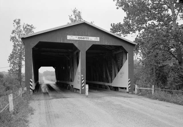
Photo: Jack E. Boucher, Historic American Buildings Survey, Library of Congress, public domain · Wikimedia Commons
Local history sources: en.wikipedia.org · en.wikipedia.org · en.wikipedia.org · commons.wikimedia.org
Historic places
3 places in Eaton on the National Register of Historic Places. Press a pin or a name for its whole record.
-
Acton HouseBuilding · Eaton · listed 1985
- Address
- 115 W. Main St.
- Where
- Eaton, Preble County · ZIP 45320
- What it is
- Building
- Listed on the National Register
- 1985
- NRIS reference number
- 85001944
- Coordinates
- 39.74383, -84.63699
National Register file (NPS) ↗ Search Wikipedia ↗ Street map and directions ↗ On the Cracked Buckeye map
-
Eaton High SchoolBuilding · Eaton · listed 2014
- Address
- 307 Cherry St.
- Where
- Eaton, Preble County · ZIP 45320
- What it is
- Building
- Listed on the National Register
- 2014
- NRIS reference number
- 14001052
- Coordinates
- 39.74552, -84.63576
National Register file (NPS) ↗ Search Wikipedia ↗ Street map and directions ↗ On the Cracked Buckeye map
-
St. Clair Street BridgeStructure · Eaton · listed 1978
- Address
- over Seven Mile Creek
- Where
- Eaton, Preble County · ZIP 45320
- What it is
- Structure
- Listed on the National Register
- 1978
- NRIS reference number
- 78002175
- Coordinates
- 39.73998, -84.63852
National Register file (NPS) ↗ Search Wikipedia ↗ Street map and directions ↗ On the Cracked Buckeye map
Source: National Park Service, National Register of Historic Places point file. The listing year is shown where NPS's certification date agrees with the listing's reference number. Listing recognizes significance; it does not restrict a private owner.
Water
Groundwater pumped from 8 wells from 3 wellfield sources (City of Eaton CCR wording). The CCR does not name the aquifer type. The water here
- Eaton Public Water System71% of residentsSand and gravel (Pleistocene) aquifer wells, Preble County
- Lakengren Water Authority29% of residentsGroundwater wells (3 wells)
- Gratis Village0% of residentsGroundwater wells (2 wells)
Hospitals, fire stations and more
Inside Eaton's boundary: 2 dialysis centers, 3 nursing homes, 2 fire and EMS stations, 4 public schools, 1 poor-rated bridge, 3 libraries, 2 police stations, 5 Toxics Release Inventory facilities and 5 spill cases. Press a pin or a name for its whole record and its source.
Dialysis centers (2)
-
Davita Eaton DialysisDialysis · Eaton
- Address
- 105 East Washington Jackson Road, Eaton, OH 45320
- Dialysis stations
- 12
- Medicare star rating
- 1 of 5 stars
- Services
- in-center hemodialysis, peritoneal dialysis
- Ownership
- for profit
- Chain
- DaVita
- Medicare certified since
- 2007-11-29
- Phone
- (937) 456-1174
- Medicare ID
- 362703
Medicare Care Compare ↗ CMS dialysis facility list (source) ↗ Street map and directions ↗
-
Fmc - Preble County Regional Dialysis, Inc.Dialysis · Eaton
- Address
- 450 D. Washington - Jackson Rd., Eaton, OH 45320
- Dialysis stations
- 15
- Medicare star rating
- 4 of 5 stars
- Services
- in-center hemodialysis
- Ownership
- for profit
- Chain
- Fresenius Medical Care
- Medicare certified since
- 2008-07-09
- Phone
- (937) 456-0400
- Medicare ID
- 362720
Medicare Care Compare ↗ CMS dialysis facility list (source) ↗ Street map and directions ↗
Source: CMS dialysis facility list, September 2026, geocoded with the Census Bureau batch geocoder (an address it could not place sits at its ZIP center).
Nursing homes (3)
-
Greenbriar Nursing Center5 of 5 stars · Eaton
- Address
- 501 West Lexington Road, Eaton, OH 45320
- Certified beds
- 74
- Residents on an average day
- 67
- Medicare overall rating
- 5 of 5 stars
- Health inspections
- 4 of 5 stars
- Staffing
- 2 of 5 stars
- Quality measures
- 5 of 5 stars
- Penalties since 2023
- 1 fine totalling $28,626 (latest 2025-04-11)
- Ownership
- For profit - Corporation
- Chain
- LIONSTONE CARE
- Takes
- Medicare and Medicaid
- Phone
- (937) 456-9535
- Medicare ID
- 365854
Medicare Care Compare ↗ CMS nursing home data (source) ↗ Street map and directions ↗
-
Maple Gardens Rehabilitiation and Nursing Center4 of 5 stars · Eaton
- Address
- 515 South Maple Street, Eaton, OH 45320
- Certified beds
- 85
- Residents on an average day
- 68
- Medicare overall rating
- 4 of 5 stars
- Health inspections
- 4 of 5 stars
- Staffing
- 1 of 5 stars
- Quality measures
- 5 of 5 stars
- Penalties since 2023
- none
- Ownership
- For profit - Limited Liability company
- Chain
- GARDEN HEALTHCARE GROUP
- Takes
- Medicare and Medicaid
- Phone
- (937) 456-5537
- Medicare ID
- 365557
Medicare Care Compare ↗ CMS nursing home data (source) ↗ Street map and directions ↗
-
Vancrest Health Care Center of Eaton3 of 5 stars · Eaton
- Address
- 1600 Park Avenue, Eaton, OH 45320
- Certified beds
- 81
- Residents on an average day
- 68
- Medicare overall rating
- 3 of 5 stars
- Health inspections
- 3 of 5 stars
- Staffing
- 3 of 5 stars
- Quality measures
- 4 of 5 stars
- Penalties since 2023
- none
- Ownership
- For profit - Limited Liability company
- Chain
- VANCREST HEALTH CARE CENTERS
- Takes
- Medicare and Medicaid
- Phone
- (937) 456-3010
- Medicare ID
- 366084
Medicare Care Compare ↗ CMS nursing home data (source) ↗ Street map and directions ↗
Source: CMS Care Compare nursing home provider and penalties files; Medicare star ratings run 1 to 5.
Fire and EMS stations (2)
-
Eaton Fire and EMS Division Station 1Eaton
- Address
- 328 North Maple Street, Eaton, OH 45320
- Coordinates
- 39.74739, -84.63267
USGS National Map structures (source) ↗ Street map and directions ↗
-
Eaton Fire and EMS Division Station 2Eaton
- Address
- 391 West Lexington Road, Eaton, OH 45320
- Coordinates
- 39.75807, -84.64132
USGS National Map structures (source) ↗ Street map and directions ↗
Source: USGS National Map structures (most Ohio records last updated 2019 to 2022), checked against the Columbus and Cleveland station lists. The department that answers a call is set by jurisdiction and mutual aid, not by distance.
Public schools (4)
-
Eaton High School3 of 5 stars · Eaton
- Address
- 600 Hillcrest Dr, Eaton, OH 45320
- School district
- Eaton Community Schools City School District
- Kind (NCES)
- Regular School
- Students, 2023-24
- 549
- Teachers (full-time equivalent)
- 35
- Report card, 2025-26
- 3 of 5 stars
- Performance index
- 77.8%
- Four-year graduation rate
- 94.3%
- Ohio building IRN
- 009803
- NCES school ID
- 390439300884
NCES school record ↗ Ohio School Report Card ↗ Street map and directions ↗
-
Eaton Middle School4 of 5 stars · Eaton
- Address
- 814 Camden Rd, Eaton, OH 45320
- School district
- Eaton Community Schools City School District
- Kind (NCES)
- Regular School
- Students, 2023-24
- 444
- Teachers (full-time equivalent)
- 29
- Report card, 2025-26
- 4 of 5 stars
- Performance index
- 82.8%
- Ohio building IRN
- 008557
- NCES school ID
- 390439300883
NCES school record ↗ Ohio School Report Card ↗ Street map and directions ↗
-
Hollingsworth East Elementary School1 of 5 stars · Eaton
- Address
- 506 Aukerman St, Eaton, OH 45320
- School district
- Eaton Community Schools City School District
- Kind (NCES)
- Regular School
- Students, 2023-24
- 427
- Teachers (full-time equivalent)
- 29
- Report card, 2025-26
- 1 of 5 stars
- Ohio building IRN
- 009282
- NCES school ID
- 390439300885
NCES school record ↗ Ohio School Report Card ↗ Street map and directions ↗
-
William Bruce Elementary School4 of 5 stars · Eaton
- Address
- 506-B Aukerman St, Eaton, OH 45320
- School district
- Eaton Community Schools City School District
- Kind (NCES)
- Regular School
- Students, 2023-24
- 437
- Teachers (full-time equivalent)
- 22
- Report card, 2025-26
- 4 of 5 stars
- Performance index
- 78.5%
- Ohio building IRN
- 003954
- NCES school ID
- 390439300882
NCES school record ↗ Ohio School Report Card ↗ Street map and directions ↗
Source: NCES EDGE public school locations 2024-25 and Common Core of Data 2023-24 (type, students, teachers); Ohio School Report Cards 2025-26 (Department of Education and Workforce), matched by name within the district.
Bridges rated poor (1)
-
St Clair Street over Trib To Seven Mile CreekPoor · built 1900
- Condition
- Poor: a deck, superstructure, substructure or culvert rated 4 or below on the 0 to 9 scale
- What it is
- Bridge
- Built
- 1900
- Length
- 33 ft
- Owner
- City
- Vehicles a day
- 463
- Coordinates
- 39.73995, -84.63857
National Bridge Inventory (source) ↗ Street map and directions ↗
Source: FHWA National Bridge Inventory 2025. "Poor" means one major part rated 4 or below on the 0 to 9 scale; it calls for repair, not closing, unless the state posts or closes the bridge.
Public libraries (3)
-
Brooke-Gould Memorial BranchBranch · Eaton
- Address
- 301 N. Barron St., Eaton, OH 45320
- What it is
- Branch
- Library system
- Preble County District Library
- Open
- 3,120 hours a year, 52 weeks
- Building
- 8,833 sq ft
- System's visits, FY2024
- 198,224
- System's loans, FY2024
- 222,960
- People the system serves
- 38,015
- Phone
- (937) 456-4331
IMLS Public Libraries Survey (source) ↗ Street map and directions ↗
-
Preble County Administrative BranchBranch · Eaton
- Address
- 450 S. Barron St., Eaton, OH 45320
- What it is
- Branch
- Library system
- Preble County District Library
- Open
- 1,976 hours a year, 52 weeks
- Building
- 500 sq ft
- System's visits, FY2024
- 198,224
- System's loans, FY2024
- 222,960
- People the system serves
- 38,015
- Phone
- (937) 456-4250
IMLS Public Libraries Survey (source) ↗ Street map and directions ↗
-
Preble County RoomBranch · Eaton
- Address
- 450 S. Barron St., Eaton, OH 45320
- What it is
- Branch
- Library system
- Preble County District Library
- Open
- 1,976 hours a year, 52 weeks
- Building
- 6,982 sq ft
- System's visits, FY2024
- 198,224
- System's loans, FY2024
- 222,960
- People the system serves
- 38,015
- Phone
- (937) 456-4970
IMLS Public Libraries Survey (source) ↗ Street map and directions ↗
Source: IMLS Public Libraries Survey FY2024 (outlets and their systems). Any Ohio resident can get a free card at any Ohio public library.
Police stations (2)
-
Eaton Police DivisionEaton
- Address
- 328 North Maple Street, Eaton, OH 45320
- Coordinates
- 39.74755, -84.63267
USGS National Map structures (source) ↗ Street map and directions ↗
-
Preble County Sheriff's OfficeEaton
- Address
- 1139 Preble Drive, Eaton, OH 45320
- Coordinates
- 39.76092, -84.64454
USGS National Map structures (source) ↗ Street map and directions ↗
Source: USGS National Map structures, police stations, corrected and completed by hand (September 2026). The department that answers a call is set by jurisdiction, not by distance.
Facilities reporting toxic releases (5)
-
Maxxim MedicalToxics Release Inventory · Eaton
- Address
- 1000 Us Route 35 West, Eaton, OH 45320
- County
- Preble County
- Status
- Reports to the Toxics Release Inventory (active)
- EPA program ID
- 45320BXTRHRT35W
- EPA registry ID
- 110000394010
EPA facility record ↗ EPA Facility Registry Service (source) ↗ Street map and directions ↗
-
Neaton Auto Products Manufacturing IncToxics Release Inventory · Eaton
- Address
- 975 South Franklin Street, Eaton, OH 45320
- County
- Preble County
- Status
- Reports to the Toxics Release Inventory (open)
- EPA program ID
- 45320NTNTP975SO
- EPA registry ID
- 110000394029
EPA facility record ↗ EPA Facility Registry Service (source) ↗ Street map and directions ↗
-
Parker Hannifin Corp. - Eaton Plant (0868030048)Toxics Release Inventory · Eaton
- Address
- 725 N Beech St, Eaton, OH 45320
- County
- Preble County County
- Status
- Reports to the Toxics Release Inventory (open)
- EPA program ID
- 45320PRKRH725NO
- EPA registry ID
- 110000394038
EPA facility record ↗ EPA Facility Registry Service (source) ↗ Street map and directions ↗
-
Silfex IncToxics Release Inventory · Eaton
- Address
- 950 S. Franklin St., Eaton, OH 45320
- County
- Preble County
- Status
- Reports to the Toxics Release Inventory (active)
- EPA program ID
- 45320BLLNL950SF
- EPA registry ID
- 110002113515
EPA facility record ↗ EPA Facility Registry Service (source) ↗ Street map and directions ↗
-
Timkensteel Corp - St Clair Precision Tubing Components PlantToxics Release Inventory · Eaton
- Address
- 401 Industrial Dr, Eaton, OH 45320
- County
- Preble County
- Status
- Reports to the Toxics Release Inventory (active)
- EPA program ID
- 45320TMKNC401IN
- EPA registry ID
- 110000394047
EPA facility record ↗ EPA Facility Registry Service (source) ↗ Street map and directions ↗
Source: EPA Facility Registry Service, Toxics Release Inventory reporters. Reporting a release is required of large users of listed chemicals; it is not by itself a violation.
Spills reported since 2021 (5)
-
Oil Hydraulic Fluid(S)2025-03-20 · Eaton
- Reported
- 2025-03-20
- What spilled
- Oil Hydraulic Fluid(S)
- Largest amount reported
- 3 gallons
- Where
- Eaton, Preble County
- Ohio EPA district office
- SWDO
- Ohio EPA case number
- 2503EPA0000403
Ohio EPA spill reports (source) ↗ Street map and directions ↗
-
Fuel Diesel / Diesel Fuel (Vehicle On Or Off Road)2023-09-27 · Eaton
- Reported
- 2023-09-27
- What spilled
- Fuel Diesel / Diesel Fuel (Vehicle On Or Off Road)
- Where
- Eaton, Preble County
- Ohio EPA district office
- SWDO
- Ohio EPA case number
- 2309EPA0001681
Ohio EPA spill reports (source) ↗ Street map and directions ↗
-
Oil Motor / Lube Oil / Vehicle2021-01-28 · Eaton
- Reported
- 2021-01-28
- What spilled
- Oil Motor / Lube Oil / Vehicle
- Largest amount reported
- 200 gallons
- Where
- Eaton, Preble County
- Ohio EPA district office
- SWDO
- Ohio EPA case number
- 2101EPA0000124
Ohio EPA spill reports (source) ↗ Street map and directions ↗
-
Other / All Other / Trade Name / Mixture / Solution Etc Reached water2021-01-04 · Eaton
- Reported
- 2021-01-04
- What spilled
- Other / All Other / Trade Name / Mixture / Solution Etc
- Reached a waterway
- 99 - Unnamed
- Where
- Eaton, Preble County
- Ohio EPA district office
- SWDO
- Ohio EPA case number
- 2101EPA0000008
Ohio EPA spill reports (source) ↗ Street map and directions ↗
-
Fuel Diesel / Diesel Fuel (Vehicle On Or Off Road)2026-08-12 · Eaton
- Reported
- 2026-08-12
- What spilled
- Fuel Diesel / Diesel Fuel (Vehicle On Or Off Road)
- Largest amount reported
- 50 gallons
- Where
- Eaton, Preble County
- Ohio EPA district office
- SWDO
- Ohio EPA case number
- 2608EPA0001486
Ohio EPA spill reports (source) ↗ Street map and directions ↗
Source: Ohio EPA emergency response spill reports, 2021 to September 2026, one point per case where Ohio EPA placed it. A report is what the caller or responder recorded; amounts are often blank or estimated.
Its ZIP codes
Each ZIP code that touches Eaton, with the share of its residents who live here and the same headline figures as the ZIP page.
| ZIP | Share | Water | Radon | Home value | Schools | Flood |
|---|---|---|---|---|---|---|
| 45320 Eaton | 54% | Groundwater pumped from 8 wells from 3 wellfield sources (City of Eaton CCR wording). The CCR does not name the aquifer type. | 3.7 pCi/L average radon | Parcel list only | Eaton Community Schools City · 3.5 stars overall | 1.5% of residents in the 1% floodplain |
Local government
Who holds office in Eaton, how its elections and ballot issues came out, and the state auditor's record.
Elections for office
| Date | Office | Candidates and votes |
|---|---|---|
| 2021-11-02 | Member of Council (unofficial count) | Christopher J. Carr 712, 27.89%; Brad R. Moore 933, 36.55%; Matthew S. Venable 908, 35.57% |
Winners in bold. Results from the county board of elections' official canvass unless marked.
Auditor of State record
- No fiscal caution, watch or emergency on the Auditor of State's lists.
- Financial Health Indicators (the Auditor of State's 17 measures; critical / cautionary / positive): 2020 0 / 2 / 15; 2021 0 / 0 / 17; 2022 0 / 1 / 16; 2023 0 / 1 / 16; 2024 0 / 2 / 15; 2025 0 / 2 / 15.
- Financial Audit, 2025, released 2026-08-04
- Financial Audit, 2024, released 2025-09-30
- Financial Audit, 2023, released 2024-10-01
The county
Preble County: 12 ZIP codes, 23 cities, villages and townships, 43,242 people.
Nearby places
Rain and snow
How much has actually fallen on Eaton, day by day, from 1893 to now. Daily totals, not averages.
- rain, last 30 days
- 0.86 in
- 2026-09-30 to 2026-10-29
- rain so far in 2026
- 49.0 in
- 12.5 in above normal for the date
- snow so far in 2026
- 17.7 in
- a normal year brings 19.1 in
- a normal year
- 43.1 in
- average of 30 years, 1991-2020
| Month | Rain (in) | Snow (in) | Days counted |
|---|---|---|---|
| October 2026 | 0.86 | — | 29 |
| September 2026 | 5.57 | — | 30 |
| August 2026 | 11.19 | — | 31 |
| July 2026 | 3.26 | — | 31 |
| June 2026 | 5.36 | — | 30 |
| May 2026 | 7.60 | — | 31 |
| April 2026 | 4.04 | — | 30 |
| March 2026 | 6.66 | 1.5 | 31 |
| February 2026 | 2.13 | 3.5 | 28 |
| January 2026 | 2.31 | 12.7 | 31 |
| December 2025 | 2.06 | 8.0 | 31 |
| November 2025 | 2.26 | 1.5 | 30 |
| Wettest year | 1950 — 58.4 in |
|---|---|
| Driest year | 1934 — 24.0 in |
| Snowiest year | 1918 — 66.7 in |
| Wettest day on record | 18 May 1991 — 4.28 in |
| Heaviest snowfall in a day | 15 January 1918 — 12.01 in |
| Deepest snow on the ground | 8 January 1996 — 19.02 in |
83% of these days are measurements from a gauge inside Eaton; the rest are estimated from the nearest gauges around it.
48,032 days of records, 1893-06-01 to 2026-10-29. Source: NOAA NCEI GHCN-Daily, 3,240 gauges in and around Ohio. A day is "gauged" when a gauge standing inside the boundary reported it, and the value is the mean of those gauges. Otherwise it is interpolated by inverse distance from every gauge reporting within 50 miles. Nothing is carried forward, back-filled or smoothed. Against NOAA nClimDiv county monthly precipitation over 136,848 complete county-months (checked 2026-10-31): correlation 0.9515, median absolute difference 0.217 in a month. Built 2026-10-31 from the Cracked Buckeye precipitation archive. Snow is the softer number — snowfall is measured by hand with a ruler, no agency publishes a gridded county snowfall series, and blowing snow defeats every observer.
Environmental permits and filings
What Ohio EPA has on file for Eaton: permits, inspections, violations, cleanups and the state loans behind sewer and water work. Every line links to the agency's own document.
- facilities and sites on file
- 41
- those placed on the map inside Eaton
| Program | Facilities and sites |
|---|---|
| Hazardous waste | 13 |
| State sewer loans | 11 |
| Wastewater and stormwater discharge | 10 |
| Air pollution | 7 |
| Date | Facility or site | What |
|---|---|---|
| KWCP-EATON | Wastewater and stormwater discharge permit | |
| KWCP-EATON | Wastewater and stormwater discharge permit | |
| KWCP-EATON | Wastewater and stormwater discharge permit | |
| NEATON AUTO PRODUCTS MANUFACTURING INC | Air pollution inspection | |
| PREBLE COUNTY WPCLF HSTS ASSISTANCE PROGRAM | State sewer loans | |
| WILLOW OAK CREMATORY LLC | Air pollution report | |
| CHEROKEE US 127 SOUTH | Wastewater and stormwater discharge permit | |
| NEATON AUTO PRODUCTS MANUFACTURING INC | Air pollution inspection | |
| PREBLE COUNTY WPCLF HSTS ASSISTANCE PROGRAM | State sewer loans | |
| PREBLE COUNTY WPCLF HSTS ASSISTANCE PROGRAM | State sewer loans | |
| PREBLE COUNTY US 35 EAST GLENWOOD AREA WWTP | State sewer loans | |
| MAPLE STREET PHASE 2 | Wastewater and stormwater discharge permit | |
| FUELING STATION - R&R TAKHAR | Wastewater and stormwater discharge notice of violation | |
| PRE MAPLE PH 2 (118523) | Wastewater and stormwater discharge permit | |
| PREBLE COUNTY US 35 EAST GLENWOOD AREA WWTP | State sewer loans | |
| PREBLE COUNTY WPCLF HSTS ASSISTANCE PROGRAM | State sewer loans | |
| METALLUS INC | Hazardous waste compliance letter | |
| PREBLE COUNTY WPCLF HSTS ASSISTANCE PROGRAM | State sewer loans | |
| COBBLESTONE - EATON | Wastewater and stormwater discharge inspection | |
| MAPLE STREET PHASE 2 | Wastewater and stormwater discharge permit | |
| METALLUS INC | Hazardous waste inspection | |
| PREBLE COUNTY WPCLF HSTS ASSISTANCE PROGRAM | State sewer loans | |
| PREBLE COUNTY WPCLF HSTS ASSISTANCE PROGRAM | State sewer loans | |
| EATON WWTP | State sewer loans | |
| PARKER HANNIFIN CORP EATON PLANT | Hazardous waste inspection |
Source: Ohio EPA eDocument portal (edocpub.epa.ohio.gov), indexed 2026-10-14. Facilities are placed on the map from Ohio EPA's own map layers, EPA's Facility Registry, coordinates written in the filings, or a geocoded street address. A permit filed under a private person's name (most are household septic systems) is counted but never named, placed or linked; licenses for individual workers and open-burning notices are left out entirely.
Quick answers
What county is Eaton, Ohio in?
Eaton is a city in Preble County, Ohio, with 8,375 residents.
When was Eaton, Ohio founded?
Eaton was laid out 1806. Founders on record: William Bruce. Source
How did Eaton, Ohio get its name?
Eaton was named for William Eaton (1764-1811), U.S. Source
What ZIP code is Eaton, Ohio?
Most of Eaton is in ZIP code 45320.
Where does Eaton, Ohio get its water?
The main water source for Eaton (Eaton Public Water System): Groundwater pumped from 8 wells from 3 wellfield sources (City of Eaton CCR wording). The CCR does not name the aquifer type.
Cite this page
Cite this page as:
Cracked Buckeye, "Eaton, Preble County", https://crackedbuckeye.com/place/eaton/, built 2026-10-31, accessed [date].
How to cite · Report a correction · Built 2026-10-31
