East Palestine
Village · Columbiana County · 4,746 residents · 1.5% municipal income tax
Local events in East Palestine
Nothing is posted for East Palestine itself yet; here is what is on within 10 miles. All local events in East Palestine
Know a calendar we should watch? Send the link
Checked October 20; the events page is refreshed daily.
Lakes near East Palestine
The history under the water: the valley before, the dam, the stories. All Ohio lakes
How East Palestine began
East Palestine was platted in 1828 by Thomas McCalla and William Grate as Mechanicsburg, then renamed in 1833 for the region of Palestine, part of a wave of biblically named towns in the area. It grew through the 19th and 20th centuries on ceramics and rubber manufacturing -- a pottery founded in 1880 became the W.S. George Pottery Company in 1904 and operated into the 1980s -- and peaked at nearly 5,750 residents in 1920 before a long, slow decline returned it to village status in 2011. The village became a name known nationwide on February 3, 2023, when a Norfolk Southern freight train derailed on its eastern edge and released hazardous chemicals, including vinyl chloride burned off in a controversial controlled release; the disaster's health, environmental and political fallout continues to define East Palestine's most recent chapter.
Settled 1828, platted 1828 (as Mechanicsburg), incorporated 1875, by Thomas McCalla and William Grate.
Where the name comes from
Platted in 1828 as Mechanicsburg, the village was renamed East Palestine in 1833 for the region of Palestine in West Asia, part of a broader pattern of biblical place-naming among the area's early settlers.
Before the town
No source we reviewed names a specific Native American village, camp or burial site within present East Palestine's boundaries. The GNIS historical-name record for the area lists only 'State Line,' an old post office or place name unrelated to Native settlement. The village was platted in 1828, more than three decades after the treaties that ceded this part of eastern Ohio (the 1785 Treaty of Fort McIntosh, confirmed by the 1795 Treaty of Greenville).
Timeline
- — Thomas McCalla and William Grate plat the village as Mechanicsburg.
- — The village is renamed East Palestine.
- — East Palestine incorporates.
- — A pottery is established that will grow into the W.S. George Pottery Company.
- — The pottery is reorganized as the W.S. George Pottery Company.
- — East Palestine's population peaks at 5,750.
- — The W.S. George Pottery plant ceases operation after a century in business.
- — East Palestine is reclassified from city back to village after its population fell below 5,000.
- — A Norfolk Southern freight train derails at 8:55 p.m. on the village's eastern edge after a wheel bearing overheats; 38 cars derail and 11 tank cars spill roughly 100,000 gallons of hazardous chemicals including vinyl chloride, benzene and butyl acrylate.
- — Officials conduct a controlled release and burn of vinyl chloride from five tank cars, later found by the NTSB chair to have been unnecessary; the burn releases phosgene and hydrogen chloride into the air.
- — The EPA reports removal of about 167,000 tons of contaminated soil from the derailment site.
Stories
The night the wheel bearing failed
At 8:55 p.m. on February 3, 2023, a Norfolk Southern freight train carrying hazardous chemicals derailed on the eastern edge of East Palestine after an overheated wheel bearing failed, sending 38 cars off the tracks. Eleven of the derailed tank cars carried hazardous materials, and roughly 100,000 gallons of chemicals including vinyl chloride, benzene and butyl acrylate spilled at the site. Three days later, worried the tanks could explode, officials conducted a controlled release and burn of vinyl chloride from five cars -- a decision NTSB Chair Jennifer Homendy later testified was not actually necessary, since the manufacturer had said the chemical was stable, and one that sent a black plume of phosgene and hydrogen chloride over the village. More than 43,000 aquatic animals died in nearby waterways, independent testing by Carnegie Mellon and Texas A&M later found chemicals above long-term exposure limits, and by October 2023 the EPA had hauled away some 167,000 tons of contaminated soil -- a single winter night that reshaped how the village of roughly 4,700 people is known nationally.
From Mechanicsburg to the Pottery works
East Palestine started in 1828 as Mechanicsburg, a plat laid out by Thomas McCalla and William Grate, and took its lasting name five years later as part of a local fashion for biblical place names. Its economic backbone through most of the 19th and 20th centuries was ceramics: a pottery works founded in 1880 grew into the W.S. George Pottery Company by 1904, one of several Columbiana County potteries riding the same clay deposits and river-and-rail access that made East Liverpool famous, and it kept firing kilns into the 1980s. Rubber manufacturers McGraw Tire & Rubber and National Tire & Rubber also operated in the village during its early-20th-century peak, when the population briefly touched 5,750 in 1920 -- a high-water mark East Palestine has not seen again.
Photographs
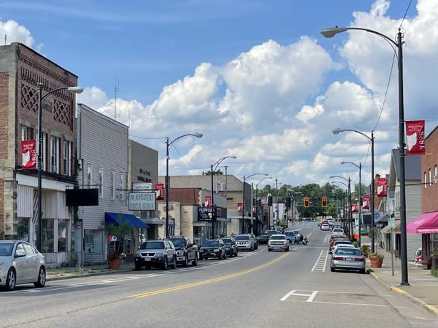
Photo: 636Buster (Wikimedia Commons), CC BY-SA 4.0 · Wikimedia Commons
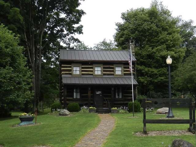
Photo: 636Buster (Wikimedia Commons), CC BY-SA 4.0 · Wikimedia Commons
Local history sources: en.wikipedia.org · en.wikipedia.org · commons.wikimedia.org · commons.wikimedia.org
Water
Groundwater wells (5 wells) The water here
- East Palestine Village100% of residentsGroundwater wells (5 wells)
Hospitals, fire stations and more
Inside East Palestine's boundary: 1 nursing home, 1 fire or EMS station, 3 public schools, 1 poor-rated bridge, 1 library, 2 museums, 1 police station, 1 Superfund site, 3 Toxics Release Inventory facilities and 10 spill cases. Press a pin or a name for its whole record and its source.
Nursing homes (1)
-
Covington Skilled Nursing & Rehab Center4 of 5 stars · East Palestine
- Address
- 100 Covington Drive, East Palestine, OH 44413
- Certified beds
- 65
- Residents on an average day
- 60
- Medicare overall rating
- 4 of 5 stars
- Health inspections
- 4 of 5 stars
- Staffing
- 2 of 5 stars
- Quality measures
- 4 of 5 stars
- Penalties since 2023
- none
- Ownership
- For profit - Corporation
- Chain
- MICHAEL SLYK
- Takes
- Medicare and Medicaid
- Phone
- (330) 426-2920
- Medicare ID
- 366378
Medicare Care Compare ↗ CMS nursing home data (source) ↗ Street map and directions ↗
Source: CMS Care Compare nursing home provider and penalties files; Medicare star ratings run 1 to 5.
Fire and EMS stations (1)
-
East Palestine Fire DepartmentEast Palestine
- Address
- 67 East Clark Street, East Palestine, OH 44413
- Coordinates
- 40.83594, -80.53880
USGS National Map structures (source) ↗ Street map and directions ↗
Source: USGS National Map structures (most Ohio records last updated 2019 to 2022), checked against the Columbus and Cleveland station lists. The department that answers a call is set by jurisdiction and mutual aid, not by distance.
Public schools (3)
-
East Palestine Elementary School4 of 5 stars · East Palestine
- Address
- 195 W Grant St, East Palestine, OH 44413
- School district
- East Palestine City School District
- Kind (NCES)
- Regular School
- Students, 2023-24
- 400
- Teachers (full-time equivalent)
- 28
- Report card, 2025-26
- 4 of 5 stars
- Performance index
- 77.4%
- Ohio building IRN
- 004838
- NCES school ID
- 390439200876
NCES school record ↗ Ohio School Report Card ↗ Street map and directions ↗
-
East Palestine High School3.5 of 5 stars · East Palestine
- Address
- 360 W Grant St, East Palestine, OH 44413
- School district
- East Palestine City School District
- Kind (NCES)
- Regular School
- Students, 2023-24
- 264
- Teachers (full-time equivalent)
- 20
- Report card, 2025-26
- 3.5 of 5 stars
- Performance index
- 70.5%
- Four-year graduation rate
- 94.3%
- Ohio building IRN
- 009134
- NCES school ID
- 390439200878
NCES school record ↗ Ohio School Report Card ↗ Street map and directions ↗
-
East Palestine Middle School3 of 5 stars · East Palestine
- Address
- 320 W Grant St, East Palestine, OH 44413
- School district
- East Palestine City School District
- Kind (NCES)
- Regular School
- Students, 2023-24
- 269
- Teachers (full-time equivalent)
- 18
- Report card, 2025-26
- 3 of 5 stars
- Performance index
- 72.2%
- Ohio building IRN
- 038844
- NCES school ID
- 390439200879
NCES school record ↗ Ohio School Report Card ↗ Street map and directions ↗
Source: NCES EDGE public school locations 2024-25 and Common Core of Data 2023-24 (type, students, teachers); Ohio School Report Cards 2025-26 (Department of Education and Workforce), matched by name within the district.
Bridges rated poor (1)
-
Hunston Rd 443 over Leslie RunPoor · built 1940
- Condition
- Poor: a deck, superstructure, substructure or culvert rated 4 or below on the 0 to 9 scale
- What it is
- Bridge
- Built
- 1940
- Length
- 12 ft
- Owner
- County
- Vehicles a day
- 1,561
- Coordinates
- 40.83395, -80.55269
National Bridge Inventory (source) ↗ Street map and directions ↗
Source: FHWA National Bridge Inventory 2025. "Poor" means one major part rated 4 or below on the 0 to 9 scale; it calls for repair, not closing, unless the state posts or closes the bridge.
Public libraries (1)
-
East Palestine Memorial Public LibraryCentral library · East Palestine
- Address
- 309 N. Market St., East Palestine, OH 44413
- What it is
- Central library
- Library system
- East Palestine Memorial Public Library
- Open
- 3,040 hours a year, 52 weeks
- Building
- 11,673 sq ft
- System's visits, FY2024
- 31,772
- System's loans, FY2024
- 53,087
- People the system serves
- 4,794
- Phone
- (330) 426-3778
IMLS Public Libraries Survey (source) ↗ Street map and directions ↗
Source: IMLS Public Libraries Survey FY2024 (outlets and their systems). Any Ohio resident can get a free card at any Ohio public library.
Museums, historical societies, gardens and zoos (2)
-
East Palestine Area Historical Society Unity & Middleton TownshipHistorical society · East Palestine
- What it is
- Historical society
- City
- East Palestine
- Coordinates
- 40.83271, -80.53679
Search Wikipedia ↗ IMLS Museum Data Files (source) ↗ Street map and directions ↗
The museum list is IMLS's 2018 file; a museum may have closed or moved since.
-
East Palestine Historical SocietyHistorical society · East Palestine
- What it is
- Historical society
- City
- East Palestine
- Coordinates
- 40.83909, -80.54573
Search Wikipedia ↗ IMLS Museum Data Files (source) ↗ Street map and directions ↗
The museum list is IMLS's 2018 file; a museum may have closed or moved since.
Source: IMLS Museum Data Files, 2018.
Police stations (1)
-
East Palestine Police DepartmentEast Palestine
- Address
- 75 East Main Street, East Palestine, OH 44413
- Coordinates
- 40.83248, -80.53835
USGS National Map structures (source) ↗ Street map and directions ↗
Source: USGS National Map structures, police stations, corrected and completed by hand (September 2026). The department that answers a call is set by jurisdiction, not by distance.
Superfund sites (1)
-
M & W FoundrySuperfund program · East Palestine
- Address
- 895 E Taggart St, East Palestine, OH 44413
- County
- Columbiana County
- Status
- Superfund program site, not on the National Priorities List
- EPA program ID
- OHN000510085
- EPA registry ID
- 110011388541
EPA facility record ↗ EPA Facility Registry Service (source) ↗ Street map and directions ↗
Source: EPA Facility Registry Service, Superfund (SEMS) and National Priorities List sites. Many program sites were assessed and needed no cleanup.
Facilities reporting toxic releases (3)
-
American Runner CoToxics Release Inventory · East Palestine
- Address
- 200 James St, East Palestine, OH 44413
- County
- Columbiana County
- Status
- Reports to the Toxics Release Inventory (active)
- EPA program ID
- 44413MRCNR200JA
- EPA registry ID
- 110002111697
EPA facility record ↗ EPA Facility Registry Service (source) ↗ Street map and directions ↗
-
East Palestine ChinaToxics Release Inventory · East Palestine
- Address
- 870 West Main St, East Palestine, OH 44413
- County
- Columbiana County
- Status
- Reports to the Toxics Release Inventory (active)
- EPA program ID
- 44413STPLS870WM
- EPA registry ID
- 110004716433
EPA facility record ↗ EPA Facility Registry Service (source) ↗ Street map and directions ↗
-
Kenmar Division of Ethan AllenToxics Release Inventory · East Palestine
- Address
- 795 E. Martin St., East Palestine, OH 44413
- County
- Columbiana County
- Status
- Reports to the Toxics Release Inventory (active)
- EPA program ID
- 44413THNLL795EA
- EPA registry ID
- 110002111704
EPA facility record ↗ EPA Facility Registry Service (source) ↗ Street map and directions ↗
Source: EPA Facility Registry Service, Toxics Release Inventory reporters. Reporting a release is required of large users of listed chemicals; it is not by itself a violation.
Spills reported since 2021 (10)
-
Material Gray Reached water2025-11-13 · East Palestine
- Reported
- 2025-11-13
- What spilled
- Material Gray
- Reached a waterway
- 99 - Unnamed
- Where
- East Palestine, Columbiana County
- Ohio EPA district office
- NEDO
- Ohio EPA case number
- 2511EPA0001858
Ohio EPA spill reports (source) ↗ Street map and directions ↗
-
Fuel Gasoline ( 25% Ethanol Not E85) Reached water2024-01-28 · East Palestine
- Reported
- 2024-01-28
- What spilled
- Fuel Gasoline ( 25% Ethanol Not E85)
- Largest amount reported
- 72 gallons
- Reached a waterway
- 15 - Sulphur Run
- Where
- East Palestine, Columbiana County
- Ohio EPA district office
- NEDO
- Ohio EPA case number
- 2401EPA0000145
Ohio EPA spill reports (source) ↗ Street map and directions ↗
-
Sheen Rainbow / Hydrocarbon Reached water2023-08-23 · East Palestine
- Reported
- 2023-08-23
- What spilled
- Sheen Rainbow / Hydrocarbon
- Reached a waterway
- 15 - Sulphur Run
- Where
- East Palestine, Columbiana County
- Ohio EPA district office
- NEDO
- Ohio EPA case number
- 2308EPA0001461
Ohio EPA spill reports (source) ↗ Street map and directions ↗
-
Soap Nos (Not Specified) Reached water2023-06-01 · East Palestine
- Reported
- 2023-06-01
- What spilled
- Soap Nos (Not Specified)
- Largest amount reported
- 2 gallons
- Reached a waterway
- 15 - Sulphur Run
- Where
- East Palestine, Columbiana County
- Ohio EPA district office
- NEDO
- Ohio EPA case number
- 2306EPA0000898
Ohio EPA spill reports (source) ↗ Street map and directions ↗
-
Sheen Rainbow / Hydrocarbon2023-04-07 · East Palestine
- Reported
- 2023-04-07
- What spilled
- Sheen Rainbow / Hydrocarbon
- Where
- East Palestine, Columbiana County
- Ohio EPA district office
- NEDO
- Ohio EPA case number
- 2304EPA0000535
Ohio EPA spill reports (source) ↗ Street map and directions ↗
-
Fuel Diesel / Diesel Fuel (Vehicle On Or Off Road)2023-01-04 · East Palestine
- Reported
- 2023-01-04
- What spilled
- Fuel Diesel / Diesel Fuel (Vehicle On Or Off Road)
- Largest amount reported
- 30 gallons
- Where
- East Palestine, Columbiana County
- Ohio EPA district office
- NEDO
- Ohio EPA case number
- 2301EPA0000021
Ohio EPA spill reports (source) ↗ Street map and directions ↗
-
Sewage Human2022-02-17 · East Palestine
- Reported
- 2022-02-17
- What spilled
- Sewage Human
- Where
- East Palestine, Columbiana County
- Ohio EPA district office
- NEDO
- Ohio EPA case number
- 2202EPA0000194
Ohio EPA spill reports (source) ↗ Street map and directions ↗
-
Sewage Human2021-05-09 · East Palestine
- Reported
- 2021-05-09
- What spilled
- Sewage Human
- Where
- East Palestine, Columbiana County
- Ohio EPA district office
- NEDO
- Ohio EPA case number
- 2105EPA0000639
Ohio EPA spill reports (source) ↗ Street map and directions ↗
-
Sewage Human2026-05-24 · East Palestine
- Reported
- 2026-05-24
- What spilled
- Sewage Human
- Where
- East Palestine, Columbiana County
- Ohio EPA district office
- NEDO
- Ohio EPA case number
- 2605EPA0000888
Ohio EPA spill reports (source) ↗ Street map and directions ↗
-
Oil Petroleum Not Otherwise Specified (Nos) Reached water2026-02-18 · East Palestine
- Reported
- 2026-02-18
- What spilled
- Oil Petroleum Not Otherwise Specified (Nos); Fuel Diesel / Diesel Fuel (Vehicle On Or Off Road)
- Reached a waterway
- 15 - Sulphur Run
- Where
- East Palestine, Columbiana County
- Ohio EPA district office
- NEDO
- Ohio EPA case number
- 2602EPA0000199
Ohio EPA spill reports (source) ↗ Street map and directions ↗
Source: Ohio EPA emergency response spill reports, 2021 to September 2026, one point per case where Ohio EPA placed it. A report is what the caller or responder recorded; amounts are often blank or estimated.
Its ZIP codes
Each ZIP code that touches East Palestine, with the share of its residents who live here and the same headline figures as the ZIP page.
| ZIP | Share | Water | Radon | Home value | Schools | Flood |
|---|---|---|---|---|---|---|
| 44413 East Palestine | 66% | Groundwater wells (5 wells) | 4.1 pCi/L average radon | Appraisal records without year built | East Palestine City · 3 stars overall | 5.8% of residents in the 1% floodplain |
Local government
Who holds office in East Palestine, how its elections and ballot issues came out, and the state auditor's record.
Money issues on the ballot since 2021: 4 of 5 passed.
Ballot issues
| Date | Issue | For | Against | Result |
|---|---|---|---|---|
| 2024-11-05 | Issue: Village of East Palestine Tax Levy Roads | 993 | 1,036 | Failed (48.94% for) |
| 2023-11-07 | Issue: East Palestine Village Tax Levy Fire | 882 | 532 | Passed (62.38% for) |
| 2022-11-08 | Issue: East Palestine Village Tax Levy Park 1.0 Mill (1.0 mills) | 949 | 519 | Passed (64.65% for) |
| 2022-11-08 | Issue: East Palestine Village Tax Levy Park 2.0 Mill (2.0 mills) | 899 | 571 | Passed (61.16% for) |
| 2021-11-02 | Issue: East Palestine Tax Levy Police | 561 | 206 | Passed (73.14% for) |
| 2021-11-02 | Issue: East Palestine Charter Amendment 1 | 664 | 96 | Passed (87.37% for) |
| 2021-11-02 | Issue: East Palestine Charter Amendment 2 | 605 | 148 | Passed (80.35% for) |
| 2021-11-02 | Issue: East PalestineCharter Amendment 4 | 636 | 108 | Passed (85.48% for) |
| 2021-11-02 | Issue: East Palestine Charter Amendment 5 | 538 | 195 | Passed (73.4% for) |
| 2021-11-02 | Issue: East Palestine Charter Amendment 6 | 582 | 151 | Passed (79.4% for) |
| 2021-11-02 | Issue: East Palestine Charter Amendment 7 | 573 | 148 | Passed (79.47% for) |
| 2021-11-02 | Issue: East Palestine Charter Amendment 8 | 282 | 454 | Failed (38.32% for) |
| 2021-11-02 | Issue: East Palestine Charter Amendment 9 | 619 | 107 | Passed (85.26% for) |
| 2021-11-02 | Issue: East Palestine Charter Amendment 10 | 504 | 229 | Passed (68.76% for) |
Elections for office
| Date | Office | Candidates and votes |
|---|---|---|
| 2023-11-07 | Member of Council | Timothy J. Blythe 862, 25.64%; Neko Figley 210, 6.25%; Lenny Glavan 759, 22.58%; Bruce Grope 203, 6.04%; Linda L. May 684, 20.35%; David R. Peters 644, 19.16% |
| 2023-11-07 | Mayor | Misti Allison 614, 43.42%; Trent R. Conaway 800, 56.58% |
| 2022-11-08 | Member of Council | Linda L. May 666, 51.35%; Amanda Smith 631, 48.65% |
| 2021-11-02 | Member of Council | Don Elzer 227, 13.08%; Thomas Anthony Povenski, Jr. 538, 30.99%; Jessica Rocco 523, 30.13%; Douglas Simpson 448, 25.81% |
Winners in bold. Results from the county board of elections' official canvass unless marked.
Auditor of State record
- No fiscal caution, watch or emergency on the Auditor of State's lists.
- Financial Audit, 2024, released 2025-10-14
- Financial Audit, 2023, released 2024-12-10
The county
Columbiana County: 20 ZIP codes, 33 cities, villages and townships, 106,075 people.
Nearby places
Rain and snow
How much has actually fallen on East Palestine, day by day, from 1892 to now. Daily totals, not averages.
- rain, last 30 days
- 1.85 in
- 2026-09-30 to 2026-10-29
- rain so far in 2026
- 40.7 in
- 5.8 in above normal for the date
- snow so far in 2026
- 33.2 in
- a normal year brings 25.9 in
- a normal year
- 41.1 in
- average of 30 years, 1991-2020
| Month | Rain (in) | Snow (in) | Days counted |
|---|---|---|---|
| October 2026 | 1.85 | — | 29 |
| September 2026 | 6.39 | — | 30 |
| August 2026 | 6.00 | — | 31 |
| July 2026 | 4.92 | — | 31 |
| June 2026 | 3.21 | — | 30 |
| May 2026 | 4.99 | — | 31 |
| April 2026 | 5.37 | — | 30 |
| March 2026 | 4.62 | 3.8 | 31 |
| February 2026 | 1.02 | 6.2 | 28 |
| January 2026 | 2.34 | 23.1 | 31 |
| December 2025 | 2.55 | 10.7 | 31 |
| November 2025 | 1.90 | 0.2 | 30 |
| Wettest year | 2018 — 56.7 in |
|---|---|
| Driest year | 1963 — 27.6 in |
| Snowiest year | 1978 — 71.6 in |
| Wettest day on record | 8 June 1897 — 4.24 in |
| Heaviest snowfall in a day | 25 November 1950 — 17.29 in |
| Deepest snow on the ground | 28 November 1950 — 26.66 in |
Estimated, not measured. No rain gauge has ever stood inside East Palestine, so every figure here is worked out from the gauges around it - the nearest ones weighted most. Treat them as close estimates rather than readings.
49,124 days of records, 1892-05-01 to 2026-10-29. Source: NOAA NCEI GHCN-Daily, 3,240 gauges in and around Ohio. A day is "gauged" when a gauge standing inside the boundary reported it, and the value is the mean of those gauges. Otherwise it is interpolated by inverse distance from every gauge reporting within 50 miles. Nothing is carried forward, back-filled or smoothed. Against NOAA nClimDiv county monthly precipitation over 136,848 complete county-months (checked 2026-10-31): correlation 0.9515, median absolute difference 0.217 in a month. Built 2026-10-31 from the Cracked Buckeye precipitation archive. Snow is the softer number — snowfall is measured by hand with a ruler, no agency publishes a gridded county snowfall series, and blowing snow defeats every observer.
Environmental permits and filings
What Ohio EPA has on file for East Palestine: permits, inspections, violations, cleanups and the state loans behind sewer and water work. Every line links to the agency's own document.
- facilities and sites on file
- 34
- those placed on the map inside East Palestine
| Program | Facilities and sites |
|---|---|
| Hazardous waste | 7 |
| State water loans | 6 |
| Wastewater and stormwater discharge | 5 |
| Brownfield | 4 |
| Air pollution | 3 |
| State sewer loans | 3 |
| Contaminated-site cleanup | 1 |
| Public drinking water | 1 |
| Scrap tires | 1 |
| Source-water protection | 1 |
| Voluntary cleanup | 1 |
| Wetland and stream fill | 1 |
| Date | Facility or site | What |
|---|---|---|
| EAST PALESTINE GOVERNMENT CENTER | Wastewater and stormwater discharge permit | |
| WALNUT ST FOUNDRY EAST PALESTINE | Contaminated-site cleanup assessment | |
| BROOKDALE AVENUE BRIDGE RELOCATION ASSIGNED | Wastewater and stormwater discharge permit | |
| JASAR RECYCLING INC | Brownfield assessment | |
| WALNUT ST FOUNDRY, EAST PALESTINE | Contaminated-site cleanup assessment | |
| EAST PALESTINE PARK | Wastewater and stormwater discharge permit | |
| JASAR RECYCLING INC | Brownfield assessment | |
| EAST PALESTINE CITY PWS | Public drinking water warning letter | |
| JASAR RECYCLING INC | Brownfield assessment | |
| EAST PALESTINE GOVERNMENT CENTER | Wetland and stream fill permit | |
| JASAR RECYCLING INC | Brownfield assessment | |
| EAST PALESTINE GOVERNMENT CENTER | Wetland and stream fill permit | |
| EAST PALESTINE CITY PWS | Public drinking water compliance letter | |
| E R ADVANCED CERAMICS INC | Air pollution report | |
| EAST PALESTINE CITY PWS | Public drinking water report | |
| EAST PALESTINE PARK | Wastewater and stormwater discharge permit | |
| EAST PALESTINE PARK | Wastewater and stormwater discharge permit | |
| BROOKDALE AVENUE BRIDGE RELOCATION ASSIGNED | Wastewater and stormwater discharge permit | |
| EAST PALESTINE CITY PWS | Public drinking water inspection | |
| EAST PALESTINE CITY PWS | Public drinking water letter | |
| EAST PALESTINE CITY PWS | Public drinking water plan | |
| EAST PALESTINE LEAKE OIL | Brownfield assessment | |
| EAST PALESTINE CITY PWS | Public drinking water inspection | |
| EAST PALESTINE LEAKE OIL | Brownfield assessment | |
| EAST PALESTINE CITY PWS | Public drinking water violation resolved |
Source: Ohio EPA eDocument portal (edocpub.epa.ohio.gov), indexed 2026-10-14. Facilities are placed on the map from Ohio EPA's own map layers, EPA's Facility Registry, coordinates written in the filings, or a geocoded street address. A permit filed under a private person's name (most are household septic systems) is counted but never named, placed or linked; licenses for individual workers and open-burning notices are left out entirely.
Quick answers
What county is East Palestine, Ohio in?
East Palestine is a village in Columbiana County, Ohio, with 4,746 residents.
When was East Palestine, Ohio founded?
East Palestine was settled 1828; laid out 1828 (as Mechanicsburg); incorporated 1875. Founders on record: Thomas McCalla and William Grate. Source
How did East Palestine, Ohio get its name?
Platted in 1828 as Mechanicsburg, the village was renamed East Palestine in 1833 for the region of Palestine in West Asia, part of a broader pattern of biblical place-naming among the area's early settlers. Source
What ZIP code is East Palestine, Ohio?
Most of East Palestine is in ZIP code 44413.
Where does East Palestine, Ohio get its water?
The main water source for East Palestine (East Palestine Village): Groundwater wells (5 wells).
Cite this page
Cite this page as:
Cracked Buckeye, "East Palestine, Columbiana County", https://crackedbuckeye.com/place/east-palestine/, built 2026-10-31, accessed [date].
How to cite · Report a correction · Built 2026-10-31
