Local events in Donnelsville
Nothing is posted for Donnelsville itself yet; here is what is on within 10 miles. All local events in Donnelsville
Know a calendar we should watch? Send the link
Checked October 20; the events page is refreshed daily.
How Donnelsville began
Donnelsville is a small village in the eastern part of Bethel Township, Clark County, on the National Road (U.S. 40) seven miles west of Springfield. It takes its name from the Donnel family: Jonathan Donnel, a Pennsylvania surveyor who came west in 1795 and with David Lowry made one of the county's first settlements on Mad River, after whom Donnel's Creek is named, and his younger brother James Donnel, who with Abraham Smith platted the village, in 1830 according to a 1908 county history or surveyed it in August 1836 according to an 1881 one. A saw-mill stood there by about 1829, a bridge by 1838 and a post office from 1840. Rev. Peter Smith, author of the first book of medicine published by a resident of the county, is buried there. The village had 195 residents in 1880, peaked at 304 in 2010, and had 255 in 2020. It is separate from New Carlisle, the larger town in the same township.
Settled 1795-97 (Jonathan Donnel and David Lowry in the surrounding township; Donnel's brother James came in 1797), platted 1830 (1908 county history) or August 1836 (1881 county history); additions 1844 (Abraham Smith) and 1859 (John Leffel), by James Donnel (and, in the 1881 account, Abraham Smith).
Where the name comes from
The 1881 county history says Donnel's Creek was named in honor of Jonathan Donnel, the early settler and surveyor, and that the village 'is supposed to have been so named also,' while noting that public records show it was surveyed by James Donnel and Abraham Smith in August 1836 and 'it may be that it was named on account of the latter Donnel.' The 1908 county history says the village was first platted in 1830 by James Donnel, 'from whom no doubt it received its name.' The 1922 history says David Lowry named the creek for his friend Jonathan Donnel.
Before the town
No Native American village, mound, or trail specific to Donnelsville itself was found in the sources consulted. But the surrounding township carries real weight: on August 8, 1780, General George Rogers Clark led about 970 Kentucky militia against Piqua (Pekowi), the principal Shawnee town on the Mad River, defended by Shawnee under Chief Black Hoof with Lenape, Wyandot, and Mingo support. Clark's forces used artillery from the river bluffs to break the town's stockade and afterward burned an estimated 500 acres of the Shawnee's cornfields; the battle is described as the largest fought west of the Alleghenies during the Revolutionary War. The defeat forced the Shawnee to abandon the Mad River valley for the Great Miami River, where they built a new town they called Peckuwe (the modern city of Piqua, Ohio, took this name). That battle site sits in Bethel Township itself, the same township as Donnelsville, some miles to the west near the Mad River — making this one of the township's most consequential events, even though it predates the village's platting by half a century or more and no source ties it to the exact ground Donnelsville occupies. The Mad River and Great Miami valleys more broadly served as Shawnee and Miami hunting grounds and travel corridors through the eighteenth century. County-level native history also includes the Adena/Hopewell mound-building era. White settlement of the township began right after the Treaty of Greenville (August 3, 1795): David Lowry came down the Ohio that spring with a boat-load of locust timber and met the surveyor Jonathan Donnel near Cincinnati, and the two took up land on Mad River, Donnel's on Section 33 of what became Bethel Township; the 1922 county history says Greenville was followed by immediate land purchases.
Nations recorded here: Shawnee, Lenape (Delaware), Wyandot, Mingo (Seneca-Cayuga), Miami.
- Piqua (Pekowi) / Battle of Piqua site (battle) — Bethel Township, Clark County, on the Mad River, roughly 7 miles west of Springfield, destroyed August 8, 1780 (en.wikipedia.org)
Timeline
- — General George Rogers Clark's Kentucky militia destroy the Shawnee town of Piqua on the Mad River in what is now Bethel Township, burning the cornfields; the 1922 county history says the township's history 'begins with' the battle.
- — The surveyor Jonathan Donnel, born in Lycoming County, Pennsylvania, comes west, meets David Lowry near Cincinnati and joins him in the first known settlement in this part of the county; Donnel selects part of Section 33 of what is now Bethel Township.
- — Jonathan Donnel returns to Pennsylvania and brings out his brother James, then eight years old, whom he raises.
- — Jonathan Donnel builds the first mill in Bethel Township, a log saw-mill on Donnel's Creek, which a freshet later sweeps away; David Lowry's grist-mill follows in 1808, and Donnel wins a damages suit over Lowry's dam, the two remaining friends.
- — Jonathan Donnel dies by his own hand in a spring-house in Springfield Township, after losing money supplying the army in the War of 1812; the 1881 history dates it 1815 or 1816, the 1922 history 1812.
- — Rev. Peter Smith, author of The Indian Doctor's Dispensatory (1813), dies and is buried at Donnelsville.
- — Major Abraham Smith builds a saw-mill in Donnelsville, where a mill still stood in 1881.
- — James Donnel platts the village with lots 1-36 on both sides of the National Road (date from the 1908 history).
- — The 1881 county history says the town was surveyed by James Donnel and Abraham Smith in this month.
- — A bridge is built at Donnelsville.
- — A post office named Donnelsville is established.
- — Abraham Smith makes an addition of lots 38-54 north of the first plat; John Leffel platts more lots in 1859.
- — The village records 196 residents in that year's federal census.
- — The Clark County Pomona Grange is first organized at Donnelsville; a Lutheran congregation that had met since about 1830 builds its church in the village.
- — The census bulletin counts 195 residents in Donnelsville village, within Bethel Township's 3,133.
- — Village population reaches its recorded peak of 304.
- — The census records 255 residents.
Stories
Jonathan Donnel and David Lowry
The creek and the village at Donnelsville carry the name of Jonathan Donnel, who came west from Lycoming County, Pennsylvania in the spring of 1795, the year of the Treaty of Greenville. Near Cincinnati he met David Lowry, a Scot's son who had come down the Ohio with a boat-load of locust timber, and the two went north together to Mad River; Lowry gave the creek on their claims Donnel's name. Donnel, an able surveyor and farmer who even made wine from his grapes, built the township's first mill, a log saw-mill, about 1804, and when Lowry's dam backed water onto it, Donnel sued, won damages in Urbana, and stayed Lowry's friend. After the War of 1812, in which he supplied the army, he lost much of his property, and ill health and exposure led to a fit of despair in which he took his own life in a spring-house. His gravestone lay in the loft for eighty years until it went to the Clark County Historical Society.
Father Smith and the Indian Doctor's Dispensatory
Rev. Peter Smith, born in Wales in 1753 and educated at Princeton, lived along Mad River as a minister and herb doctor and is buried at Donnelsville; he died on December 31, 1816. In 1813 he had a book printed for himself in Cincinnati, The Indian Doctor's Dispensatory, Being Father Smith's Advice Respecting Diseases and Their Cure, the oldest publication by a resident of what is now Clark County and, in Dr. John Uri Lloyd's judgment, the first materia medica published in the West. By the 1890s no copy seemed to survive. Lloyd, the Cincinnati pharmacist and antiquarian, learned in a casual conversation at Middle Bass Island that General J. Warren Keifer of Springfield, Smith's grandson, owned one, and Lloyd republished the book in 1898.
Photographs
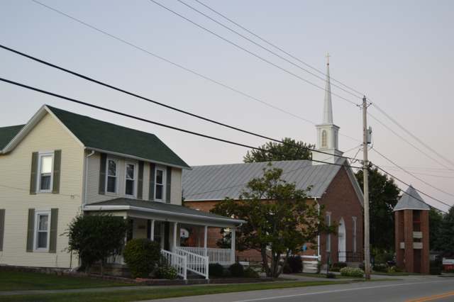
Photo: Nyttend, public domain · Wikimedia Commons
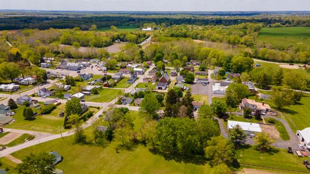
Photo: Logan Rickert, CC BY 2.0 · Wikimedia Commons
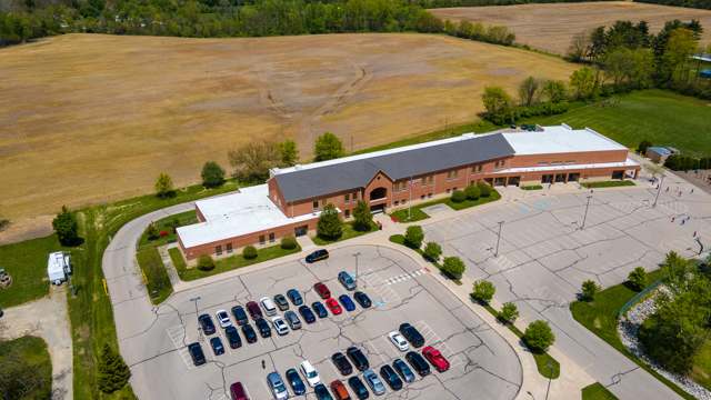
Photo: Logan Rickert, CC BY 2.0 · Wikimedia Commons
Local history sources: en.wikipedia.org · en.wikipedia.org · en.wikipedia.org · en.wikipedia.org · archive.org · archive.org · archive.org · en.wikipedia.org · commons.wikimedia.org · commons.wikimedia.org · commons.wikimedia.org
Water
No water-system data is linked to Donnelsville's ZIP codes yet.
Hospitals, fire stations and more
Inside Donnelsville's boundary: 1 fire or EMS station and 1 public school. Press a pin or a name for its whole record and its source.
Fire and EMS stations (1)
-
Bethel Township Fire Department Station 54Donnelsville
- Address
- 170 East Main Street, Donnelsville, OH 45319
- Coordinates
- 39.91860, -83.94239
USGS National Map structures (source) ↗ Street map and directions ↗
Source: USGS National Map structures (most Ohio records last updated 2019 to 2022), checked against the Columbus and Cleveland station lists. The department that answers a call is set by jurisdiction and mutual aid, not by distance.
Public schools (1)
-
Donnelsville Elementary School4.5 of 5 stars · Donnelsville
- Address
- 150 E. Main St, Donnelsville, OH 45319
- School district
- Tecumseh Local School District
- Kind (NCES)
- Regular School
- Students, 2023-24
- 353
- Teachers (full-time equivalent)
- 16
- Report card, 2025-26
- 4.5 of 5 stars
- Performance index
- 81.1%
- Ohio building IRN
- 008615
- NCES school ID
- 390462402478
NCES school record ↗ Ohio School Report Card ↗ Street map and directions ↗
Source: NCES EDGE public school locations 2024-25 and Common Core of Data 2023-24 (type, students, teachers); Ohio School Report Cards 2025-26 (Department of Education and Workforce), matched by name within the district.
Its ZIP codes
Each ZIP code that touches Donnelsville, with the share of its residents who live here and the same headline figures as the ZIP page.
| ZIP | Share | Water | Radon | Home value | Schools | Flood |
|---|---|---|---|---|---|---|
| 45319 Donnelsville | 88% | Mostly private wells | 10.1 pCi/L average radon | Median year built 1926 | Tecumseh Local · 3 stars overall | 9.1% of residents in the 1% floodplain |
Local government
Who holds office in Donnelsville, how its elections and ballot issues came out, and the state auditor's record.
Auditor of State record
- No fiscal caution, watch or emergency on the Auditor of State's lists.
- Agreed Upon Procedures, 2023 to 2024, released 2025-12-23
The county
Clark County: 15 ZIP codes, 19 cities, villages and townships, 135,514 people.
Nearby places
Rain and snow
How much has actually fallen on Donnelsville, day by day, from 1893 to now. Daily totals, not averages.
- rain, last 30 days
- 1.58 in
- 2026-09-30 to 2026-10-29
- rain so far in 2026
- 42.7 in
- 7.1 in above normal for the date
- snow so far in 2026
- 19.6 in
- a normal year brings 18.6 in
- a normal year
- 41.8 in
- average of 30 years, 1991-2020
| Month | Rain (in) | Snow (in) | Days counted |
|---|---|---|---|
| October 2026 | 1.58 | — | 29 |
| September 2026 | 4.57 | — | 30 |
| August 2026 | 7.33 | — | 31 |
| July 2026 | 2.67 | — | 31 |
| June 2026 | 3.59 | — | 30 |
| May 2026 | 9.06 | — | 31 |
| April 2026 | 3.47 | — | 30 |
| March 2026 | 6.83 | 1.2 | 31 |
| February 2026 | 2.01 | 4.1 | 28 |
| January 2026 | 1.60 | 14.2 | 31 |
| December 2025 | 2.34 | 8.4 | 31 |
| November 2025 | 2.09 | 2.7 | 30 |
| Wettest year | 2011 — 60.9 in |
|---|---|
| Driest year | 1934 — 24.3 in |
| Snowiest year | 1917 — 47.2 in |
| Wettest day on record | 26 June 1971 — 4.63 in |
| Heaviest snowfall in a day | 23 December 2004 — 12.15 in |
| Deepest snow on the ground | 21 January 1978 — 18.92 in |
Estimated, not measured. No rain gauge has ever stood inside Donnelsville, so every figure here is worked out from the gauges around it - the nearest ones weighted most. Treat them as close estimates rather than readings.
47,688 days of records, 1893-01-01 to 2026-10-29. Source: NOAA NCEI GHCN-Daily, 3,240 gauges in and around Ohio. A day is "gauged" when a gauge standing inside the boundary reported it, and the value is the mean of those gauges. Otherwise it is interpolated by inverse distance from every gauge reporting within 50 miles. Nothing is carried forward, back-filled or smoothed. Against NOAA nClimDiv county monthly precipitation over 136,848 complete county-months (checked 2026-10-31): correlation 0.9515, median absolute difference 0.217 in a month. Built 2026-10-31 from the Cracked Buckeye precipitation archive. Snow is the softer number — snowfall is measured by hand with a ruler, no agency publishes a gridded county snowfall series, and blowing snow defeats every observer.
Environmental permits and filings
What Ohio EPA has on file for Donnelsville: permits, inspections, violations, cleanups and the state loans behind sewer and water work. Every line links to the agency's own document.
- facilities and sites on file
- 4
- those placed on the map inside Donnelsville
| Program | Facilities and sites |
|---|---|
| Public drinking water | 3 |
| Source-water protection | 1 |
| Date | Facility or site | What |
|---|---|---|
| DONNELSVILLE ELEMENTARY CAMPUS PWS | Public drinking water compliance letter | |
| ARISE IN CHRIST PWS | Public drinking water inspection | |
| DONNELSVILLE ELEMENTARY CAMPUS PWS | Public drinking water inspection | |
| ARISE IN CHRIST PWS | Public drinking water inspection | |
| ARISE IN CHRIST PWS | Public drinking water notice of violation | |
| ARISE IN CHRIST PWS | Public drinking water inspection | |
| DONNELSVILLE ELEMENTARY CAMPUS PWS | Public drinking water compliance letter | |
| DONNELSVILLE ELEMENTARY CAMPUS PWS | Source-water protection report | |
| ARISE IN CHRIST PWS | Public drinking water notice of violation | |
| ARISE IN CHRIST PWS | Public drinking water notice of violation | |
| ARISE IN CHRIST PWS | Public drinking water notice of violation | |
| ARISE IN CHRIST PWS | Public drinking water inspection | |
| ARISE IN CHRIST PWS | Public drinking water notice of violation | |
| ARISE IN CHRIST PWS | Public drinking water notice of violation | |
| ARISE IN CHRIST PWS | Public drinking water director's orders | |
| DONNELSVILLE ELEMENTARY CAMPUS PWS | Public drinking water monitoring results | |
| DONNELSVILLE ELEMENTARY CAMPUS PWS | Public drinking water compliance letter | |
| ARISE IN CHRIST PWS | Public drinking water director's orders | |
| ARISE IN CHRIST PWS | Public drinking water notice of violation | |
| ARISE IN CHRIST PWS | Public drinking water notice of violation | |
| ARISE IN CHRIST PWS | Public drinking water inspection | |
| ARISE IN CHRIST PWS | Public drinking water monitoring results | |
| ARISE IN CHRIST PWS | Public drinking water notice of violation | |
| ARISE IN CHRIST PWS | Public drinking water warning letter | |
| ARISE IN CHRIST PWS | Public drinking water inspection |
Source: Ohio EPA eDocument portal (edocpub.epa.ohio.gov), indexed 2026-10-14. Facilities are placed on the map from Ohio EPA's own map layers, EPA's Facility Registry, coordinates written in the filings, or a geocoded street address. A permit filed under a private person's name (most are household septic systems) is counted but never named, placed or linked; licenses for individual workers and open-burning notices are left out entirely.
Quick answers
What county is Donnelsville, Ohio in?
Donnelsville is a village in Clark County, Ohio, with 255 residents.
When was Donnelsville, Ohio founded?
Donnelsville was settled 1795-97 (Jonathan Donnel and David Lowry in the surrounding township; Donnel's brother James came in 1797); laid out 1830 (1908 county history) or August 1836 (1881 county history); additions 1844 (Abraham Smith) and 1859 (John Leffel). Founders on record: James Donnel (and, in the 1881 account, Abraham Smith). Source
How did Donnelsville, Ohio get its name?
The 1881 county history says Donnel's Creek was named in honor of Jonathan Donnel, the early settler and surveyor, and that the village 'is supposed to have been so named also,' while noting that public records show it was surveyed by James Donnel and Abraham Smith in August 1836 and 'it may be that it was named on account of the latter Donnel.' The 1908 county history says the village was first platted in 1830 by James Donnel, 'from whom no doubt it received its name.' The 1922 history says David Lowry named the creek for his friend Jonathan Donnel. Source
What ZIP code is Donnelsville, Ohio?
Most of Donnelsville is in ZIP code 45319.
Where does Donnelsville, Ohio get its water?
The main water source for Donnelsville: Mostly private wells.
Cite this page
Cite this page as:
Cracked Buckeye, "Donnelsville, Clark County", https://crackedbuckeye.com/place/donnelsville/, built 2026-10-31, accessed [date].
How to cite · Report a correction · Built 2026-10-31
