Local events in Danbury Township, Ottawa County
Nothing is posted for Danbury Township itself yet; here is what is on within 10 miles. All local events in Danbury Township, Ottawa County
Know a calendar we should watch? Send the link
Checked October 20; the events page is refreshed daily.
Deep dives about Danbury Township, Ottawa County
Long reads built from maps, newspapers and public records. All deep dives
- Johnson's IslandJohnson's Island in Sandusky Bay held Confederate officers from April 1862 to September 1865, up to about 3,200 at a time. A 1910 Moses Ezekiel statue marks its cemetery.
- Lakeside ChautauquaLakeside began as a Methodist camp meeting on the Marblehead Peninsula in August 1873. Speakers there included Susan B. Anthony in 1895 and Eleanor Roosevelt in 1940.
- Marblehead LighthouseMarblehead Lighthouse was built of local limestone in 1821 and first lit in 1822. It is the oldest lighthouse in continuous operation on the Great Lakes.
How Danbury Township, Ottawa County began
Danbury Township covers the eastern Marblehead peninsula and was organized as part of Huron County in 1809, before Ottawa County itself existed; it was named for Danbury, Connecticut, home town of many of its first settlers, who arrived under Connecticut's Firelands grant. The township takes in the village of Marblehead, the Chautauqua community of Lakeside founded in 1873, and Johnson's Island in Sandusky Bay, where the Union Army held more than 15,000 Confederate officers as prisoners of war during the Civil War. Its shoreline also carries a War of 1812 battle site and the grave and house of Benajah Wolcott, the Revolutionary War veteran who became the first keeper of the Marblehead Lighthouse.
Incorporated 1809 (organized within Huron County, before Ottawa County's 1840 creation).
Where the name comes from
Named for Danbury, Connecticut, described as the native home of a large share of the township's first settlers, many of whom arrived as part of the Firelands (Sufferers' Lands) settlement granted to residents of Connecticut towns burned during the Revolutionary War.
Before the town
Danbury Township's ground was part of the Firelands tract ceded under the 1805 Treaty of Fort Industry; no source found names a specific Native village, trail, or burial site within the township, and the county is named for the Ottawa (Odawa) people. The township's War of 1812 battle site, listed on the National Register, commemorates fighting between American and British/Native forces on the peninsula rather than a Native settlement as such; no source consulted gives further detail on which action it marks or which nations' warriors were engaged.
- War of 1812 Battle Site (battle) — Danbury Township, Marblehead peninsula, 1812-1815 (en.wikipedia.org)
Timeline
- — Huron County was created by the Ohio General Assembly, and the future Danbury Township's land was organized as part of it, well before Ottawa County existed.
- — Marblehead Lighthouse was built at the peninsula's tip; Revolutionary War veteran Benajah Wolcott became its first keeper, and after his death in 1832 his wife Rachel succeeded him.
- — The Union Army opened a prisoner-of-war camp on Johnson's Island in Sandusky Bay, within the township, to hold Confederate officers.
- — Johnson's Island prison closed after more than three years of operation and over 15,000 prisoners passed through it; about 200 died there and are buried in its Confederate cemetery.
- — The Methodist Church founded the Lakeside Chautauqua community on the township's Lake Erie shore.
- — The township's War of 1812 Battle Site was listed on the National Register of Historic Places.
- — The Benajah Wolcott House, southwest of Marblehead, was listed on the National Register of Historic Places.
- — Johnson's Island was designated a National Historic Landmark.
Stories
One of the Civil War's gentler prisons
Johnson's Island sits in Sandusky Bay within Danbury Township's boundary, a 300-acre lump of land the Union Army fenced with a 15-foot stockade in 1862 to hold captured Confederate officers rather than enlisted men. Over the prison's three years of operation more than 15,000 men passed through its gates, guarded through Ohio winters that a Southern-raised officer would have found brutal even with adequate fuel and food, which were not always guaranteed. Roughly 200 prisoners died of cold, hunger, and disease, and are buried in the island's Confederate cemetery -- a real toll, but by Civil War prison-camp standards a comparatively low one; other camps on both sides killed prisoners at far higher rates. By 1865 the garrison had added Fort Johnson and Fort Hill to deter escape, though the war ended before either saw serious use. The cemetery and Fort Hill are open to the public today, and Heidelberg University runs annual archaeological digs on the site, still turning up traces of the camp beneath the field.
Photographs
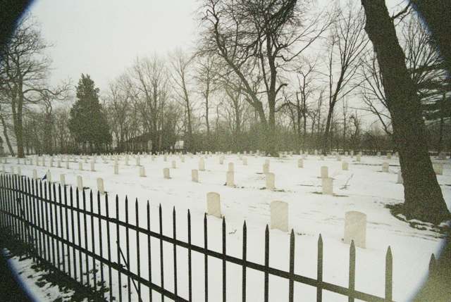
Photo: Jrbouldin, via Wikimedia Commons, public domain · Wikimedia Commons
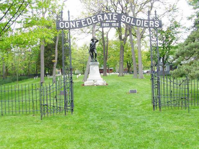
Photo: Chris Light, via Wikimedia Commons, CC BY-SA 3.0 · Wikimedia Commons
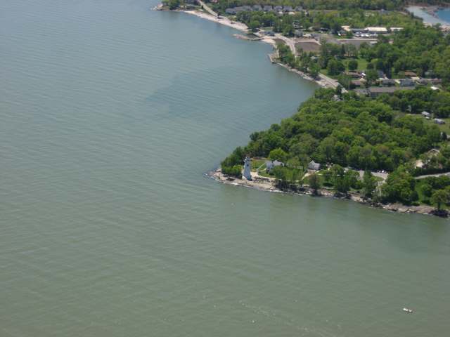
Photo: Nyttend, via Wikimedia Commons, public domain · Wikimedia Commons
Local history sources: en.wikipedia.org · en.wikipedia.org · en.wikipedia.org · en.wikipedia.org · en.wikipedia.org · en.wikipedia.org
Historic places
2 places in Danbury Township, Ottawa County on the National Register of Historic Places. Press a pin or a name for its whole record.
-
War Of 1812 Battle SiteStructure · Mineyahta-on-the-Bay · listed 1972
- Address
- East Bay Shore Rd., 1 mi. W of jct. with T-142
- Where
- Mineyahta-on-the-Bay, Ottawa County · ZIP 43440
- What it is
- Structure
- Listed on the National Register
- 1972
- NRIS reference number
- 72001038
- Coordinates
- 41.51418, -82.74518
National Register file (NPS) ↗ Search Wikipedia ↗ Street map and directions ↗ On the Cracked Buckeye map
-
Wolcott, Benajah, HouseBuilding · Lakeside--Marblehead · listed 1991
- Address
- 9999 E. Bay Shore Rd.
- Where
- Lakeside--Marblehead, Ottawa County · ZIP 43440
- What it is
- Building
- Listed on the National Register
- 1991
- NRIS reference number
- 91000251
- Coordinates
- 41.51440, -82.74818
National Register file (NPS) ↗ Search Wikipedia ↗ Street map and directions ↗ On the Cracked Buckeye map
Source: National Park Service, National Register of Historic Places point file. The listing year is shown where NPS's certification date agrees with the listing's reference number. Listing recognizes significance; it does not restrict a private owner.
Water
Mostly private wells The water here
- Marblehead Village55% of residentsLake Erie
- Ottawa County Regional Water District40% of residentsLake Erie
- Port Clinton City6% of residentsLake Erie
- Greenwood Mobile Home Park0% of residentsGroundwater wells (1 wells)
Hospitals, fire stations and more
Inside Danbury Township, Ottawa County's boundary: 1 nursing home, 3 fire and EMS stations, 3 public schools, 3 museums, 1 police station and 10 spill cases. Press a pin or a name for its whole record and its source.
Nursing homes (1)
-
Otterbein North Shore5 of 5 stars · Lakeside
- Address
- 9400 North Shore Blvd, Lakeside, OH 43440
- Certified beds
- 20
- Residents on an average day
- 19
- Medicare overall rating
- 5 of 5 stars
- Health inspections
- 4 of 5 stars
- Staffing
- 5 of 5 stars
- Quality measures
- 4 of 5 stars
- Penalties since 2023
- none
- Ownership
- Non profit - Corporation
- Chain
- OTTERBEIN SENIORLIFE
- Continuing care retirement community
- Yes
- Takes
- Medicare and Medicaid
- Phone
- (419) 798-8203
- Medicare ID
- 366358
Medicare Care Compare ↗ CMS nursing home data (source) ↗ Street map and directions ↗
Source: CMS Care Compare nursing home provider and penalties files; Medicare star ratings run 1 to 5.
Fire and EMS stations (3)
-
Danbury Township Fire Department Station 1Marblehead
- Address
- 9551 East Harbor Road, Marblehead, OH 43440
- Coordinates
- 41.53718, -82.75266
USGS National Map structures (source) ↗ Street map and directions ↗
-
Danbury Township Fire Department Station 2Marblehead
- Address
- 150 South Bridge Road, Marblehead, OH 43440
- Coordinates
- 41.52887, -82.83037
USGS National Map structures (source) ↗ Street map and directions ↗
-
Marblehead Fire Department Station 2Marblehead
- Address
- 1525 South Danbury Road, Marblehead, OH 43440
- Coordinates
- 41.50829, -82.82864
USGS National Map structures (source) ↗ Street map and directions ↗
Source: USGS National Map structures (most Ohio records last updated 2019 to 2022), checked against the Columbus and Cleveland station lists. The department that answers a call is set by jurisdiction and mutual aid, not by distance.
Public schools (3)
-
Danbury Elementary School4 of 5 stars · Lakeside Marblehead
- Address
- 9451 E Harbor Rd, Lakeside Marblehead, OH 43440
- School district
- Danbury Local School District
- Kind (NCES)
- Regular School
- Students, 2023-24
- 261
- Teachers (full-time equivalent)
- 13
- Report card, 2025-26
- 4 of 5 stars
- Performance index
- 93%
- Ohio building IRN
- 008045
- NCES school ID
- 390489303456
NCES school record ↗ Ohio School Report Card ↗ Street map and directions ↗
-
Danbury High School4.5 of 5 stars · Lakeside Marblehead
- Address
- 9451 E Harbor Rd, Lakeside Marblehead, OH 43440
- School district
- Danbury Local School District
- Kind (NCES)
- Regular School
- Students, 2023-24
- 163
- Teachers (full-time equivalent)
- 14
- Report card, 2025-26
- 4.5 of 5 stars
- Performance index
- 87%
- Four-year graduation rate
- 100%
- Ohio building IRN
- 008052
- NCES school ID
- 390489303457
NCES school record ↗ Ohio School Report Card ↗ Street map and directions ↗
-
Danbury Middle School5 of 5 stars · Lakeside
- Address
- 9451 E Harbor Rd, Lakeside, OH 43440
- School district
- Danbury Local School District
- Kind (NCES)
- Regular School
- Students, 2023-24
- 120
- Teachers (full-time equivalent)
- 8
- Report card, 2025-26
- 5 of 5 stars
- Performance index
- 89.8%
- Ohio building IRN
- 010244
- NCES school ID
- 390489305486
NCES school record ↗ Ohio School Report Card ↗ Street map and directions ↗
Source: NCES EDGE public school locations 2024-25 and Common Core of Data 2023-24 (type, students, teachers); Ohio School Report Cards 2025-26 (Department of Education and Workforce), matched by name within the district.
Museums, historical societies, gardens and zoos (3)
-
African Safari Wildlife ParkZoo, aquarium or wildlife conservation · Port Clinton
- What it is
- Zoo, aquarium or wildlife conservation
- City
- Port Clinton
- Coordinates
- 41.51966, -82.85169
Search Wikipedia ↗ IMLS Museum Data Files (source) ↗ Street map and directions ↗
The museum list is IMLS's 2018 file; a museum may have closed or moved since.
-
Johnsons Island Preservation SocietyHistorical society · Marblehead
- What it is
- Historical society
- City
- Marblehead
- Coordinates
- 41.52916, -82.76225
Search Wikipedia ↗ IMLS Museum Data Files (source) ↗ Street map and directions ↗
The museum list is IMLS's 2018 file; a museum may have closed or moved since.
-
Lakeside Heritage SocietyHistorical society · Lakeside
- What it is
- Historical society
- City
- Lakeside
- Coordinates
- 41.54451, -82.75087
Search Wikipedia ↗ IMLS Museum Data Files (source) ↗ Street map and directions ↗
The museum list is IMLS's 2018 file; a museum may have closed or moved since.
Source: IMLS Museum Data Files, 2018.
Police stations (1)
-
Danbury Township Police DepartmentLakeside Marblehead
- Address
- 419 South Bridge Road, Lakeside Marblehead, OH 43440
- Coordinates
- 41.52858, -82.83024
USGS National Map structures (source) ↗ Street map and directions ↗
Source: USGS National Map structures, police stations, corrected and completed by hand (September 2026). The department that answers a call is set by jurisdiction, not by distance.
Spills reported since 2021 (10)
-
Fuel Gasoline ( 25% Ethanol Not E85)2025-07-05 · Danbury Twp
- Reported
- 2025-07-05
- What spilled
- Fuel Gasoline ( 25% Ethanol Not E85)
- Largest amount reported
- 200 gallons
- Where
- Danbury Twp, Ottawa County
- Ohio EPA district office
- NWDO
- Ohio EPA case number
- 2507EPA0001117
Ohio EPA spill reports (source) ↗ Street map and directions ↗
-
Oil Transformer Non Pcb2025-04-03 · Danbury Twp
- Reported
- 2025-04-03
- What spilled
- Oil Transformer Non Pcb
- Largest amount reported
- 30 gallons
- Where
- Danbury Twp, Ottawa County
- Ohio EPA district office
- NWDO
- Ohio EPA case number
- 2504EPA0000482
Ohio EPA spill reports (source) ↗ Street map and directions ↗
-
Material Unknown Reached water2024-09-20 · Danbury Twp
- Reported
- 2024-09-20
- What spilled
- Material Unknown
- Reached a waterway
- 99 - Unnamed
- Where
- Danbury Twp, Ottawa County
- Ohio EPA district office
- NWDO
- Ohio EPA case number
- 2409EPA0001612
Ohio EPA spill reports (source) ↗ Street map and directions ↗
-
Sheen Organic Reached water2024-07-20 · Danbury Twp
- Reported
- 2024-07-20
- What spilled
- Sheen Organic
- Reached a waterway
- 62 - Lake Erie
- Where
- Danbury Twp, Ottawa County
- Ohio EPA district office
- NWDO
- Ohio EPA case number
- 2407EPA0001237
Ohio EPA spill reports (source) ↗ Street map and directions ↗
-
Fuel Diesel / Diesel Fuel (Vehicle On Or Off Road)2024-02-27 · Danbury Twp
- Reported
- 2024-02-27
- What spilled
- Fuel Diesel / Diesel Fuel (Vehicle On Or Off Road)
- Where
- Danbury Twp, Ottawa County
- Ohio EPA district office
- NWDO
- Ohio EPA case number
- 2402EPA0000299
Ohio EPA spill reports (source) ↗ Street map and directions ↗
-
Fuel Diesel / Diesel Fuel (Vehicle On Or Off Road)2023-11-09 · Danbury Twp
- Reported
- 2023-11-09
- What spilled
- Fuel Diesel / Diesel Fuel (Vehicle On Or Off Road)
- Largest amount reported
- 30 gallons
- Where
- Danbury Twp, Ottawa County
- Ohio EPA district office
- NWDO
- Ohio EPA case number
- 2311EPA0001909
Ohio EPA spill reports (source) ↗ Street map and directions ↗
-
Fuel Diesel / Diesel Fuel (Vehicle On Or Off Road)2023-09-28 · Danbury Twp
- Reported
- 2023-09-28
- What spilled
- Fuel Diesel / Diesel Fuel (Vehicle On Or Off Road)
- Largest amount reported
- 40 gallons
- Where
- Danbury Twp, Ottawa County
- Ohio EPA district office
- NWDO
- Ohio EPA case number
- 2309EPA0001691
Ohio EPA spill reports (source) ↗ Street map and directions ↗
-
Fuel Diesel / Diesel Fuel (Vehicle On Or Off Road)2022-08-04 · Danbury Twp
- Reported
- 2022-08-04
- What spilled
- Fuel Diesel / Diesel Fuel (Vehicle On Or Off Road)
- Largest amount reported
- 150 gallons
- Where
- Danbury Twp, Ottawa County
- Ohio EPA district office
- NWDO
- Ohio EPA case number
- 2208EPA0001175
Ohio EPA spill reports (source) ↗ Street map and directions ↗
-
Sheen Organic Reached water2022-07-16 · Danbury Twp
- Reported
- 2022-07-16
- What spilled
- Sheen Organic
- Reached a waterway
- 62 - Lake Erie
- Where
- Danbury Twp, Ottawa County
- Ohio EPA district office
- NWDO
- Ohio EPA case number
- 2207EPA0001078
Ohio EPA spill reports (source) ↗ Street map and directions ↗
-
Oil Motor / Lube Oil / Vehicle2021-07-02 · Danbury Twp
- Reported
- 2021-07-02
- What spilled
- Oil Motor / Lube Oil / Vehicle
- Where
- Danbury Twp, NULL County
- Ohio EPA district office
- NWDO
- Ohio EPA case number
- 2107EPA0000984
Ohio EPA spill reports (source) ↗ Street map and directions ↗
Source: Ohio EPA emergency response spill reports, 2021 to September 2026, one point per case where Ohio EPA placed it. A report is what the caller or responder recorded; amounts are often blank or estimated.
Its ZIP codes
Each ZIP code that touches Danbury Township, Ottawa County, with the share of its residents who live here and the same headline figures as the ZIP page.
| ZIP | Share | Water | Radon | Home value | Schools | Flood |
|---|---|---|---|---|---|---|
| 43440 Danbury Township and Lakeside Marblehead | 81% | Mostly private wells | 4.8 pCi/L average radon | Median year built 1980 | Danbury Local · 4.5 stars overall | 16% of residents in the 1% floodplain |
| 43452 Port Clinton | 2% | Lake Erie, via a submerged intake crib serving the county's regional plant near Port Clinton (precise offshore crib coordinates not documented) | 3.6 pCi/L average radon | Median year built 1968 | Port Clinton City · 4.5 stars overall | 19% of residents in the 1% floodplain |
Local government
Who holds office in Danbury Township, Ottawa County, how its elections and ballot issues came out, and the state auditor's record.
Who holds office
| Office | Name | Party | Term ends | Contact |
|---|---|---|---|---|
| Fiscal Officer | Stacey K. Stetler | 2028-03-31 | 5725 E Port Clinton Eastern Rd Marblehead, OH 43440 | |
| Trustee | Dianne M. Rozak | 2027-12-31 | 5725 E Port Clinton Eastern Rd Marblehead, OH 43440 | |
| Trustee | David Hirt | 2029-12-31 | 5725 E Port Clinton Eastern Rd Marblehead, OH 43440 | |
| Trustee | John Paul Dress | 2029-12-31 | 5725 E Port Clinton Eastern Rd Marblehead, OH 43440 |
Roster as of 2026-04-10: county board of elections.
Money issues on the ballot since 2016: 4 of 5 passed; of those asking for new or higher taxes, 0 of 1.
Ballot issues
| Date | Issue | For | Against | Result |
|---|---|---|---|---|
| 2022-11-08 | Issue: Danbury Township Tax Levy Current Expenses | 1,764 | 1,034 | Passed (63.05% for) |
| 2022-11-08 | Issue: Danbury Township Tax Levy Fire | 1,957 | 860 | Passed (69.47% for) |
| 2020-11-03 | Issue: Danbury Township Tax Levy (Fire) Danbury Township | 2,216 | 1,105 | Passed (66.73% for) |
| 2020-03-17 | Issue: Danbury Township Police Tax Levy | 681 | 171 | Passed (79.93% for) |
| 2016-11-08 | Issue: Danbury Twp. (Unincorporated) Tax Levy Additional Danbury Township Hall | 1,121 | 1,235 | Failed (47.58% for) |
Elections for office
| Date | Office | Candidates and votes |
|---|---|---|
| 2025-11-04 | Trustee | John Paul Dress 907, 51.89%; Dave Hirt 841, 48.11% |
| 2025-11-04 | Fiscal Officer | Stacey Kay Stetler 562, 50.68%; Brinkley Paul 547, 49.32% |
| 2023-11-07 | Trustee | Dianne M. Rozak 1,975, 100.0% |
| 2023-11-07 | Fiscal Officer | Carolyn S. Adams 1,841, 100.0% |
Winners in bold. Results from the county board of elections' official canvass unless marked.
Auditor of State record
- No fiscal caution, watch or emergency on the Auditor of State's lists.
- Financial Audit, 2023 to 2024, released 2026-07-02
- Financial Audit, 2021 to 2022, released 2024-12-24
The county
Ottawa County: 15 ZIP codes, 19 cities, villages and townships, 38,204 people.
Nearby places
Quick answers
What county is Danbury Township, Ohio in?
Danbury Township, Ottawa County is a township in Ottawa County, Ohio, with 4,047 residents.
When was Danbury Township, Ohio founded?
Danbury Township, Ottawa County was incorporated 1809 (organized within Huron County, before Ottawa County's 1840 creation). Source
How did Danbury Township, Ohio get its name?
Named for Danbury, Connecticut, described as the native home of a large share of the township's first settlers, many of whom arrived as part of the Firelands (Sufferers' Lands) settlement granted to residents of Connecticut towns burned during the Revolutionary War. Source
What ZIP code is Danbury Township, Ohio?
Most of Danbury Township, Ottawa County is in ZIP code 43440.
Where does Danbury Township, Ohio get its water?
The main water source for Danbury Township, Ottawa County (Marblehead Village): Mostly private wells.
Cite this page
Cite this page as:
Cracked Buckeye, "Danbury Township, Ottawa County", https://crackedbuckeye.com/place/danbury-township-ottawa-county/, built 2026-10-31, accessed [date].
How to cite · Report a correction · Built 2026-10-31
