Local events in Corning
Nothing is posted for Corning itself yet; here is what is on within 10 miles. All local events in Corning
Know a calendar we should watch? Send the link
Checked October 20; the events page is refreshed daily.
How Corning began
Corning was laid out in 1878 by Joseph Rodgers and grew into a coal camp after 1879, when Rodgers sold over 8,000 acres along Sunday Creek to the Ohio Central Coal Company and New York investors moved in behind the Atlantic and Lake Erie Railway's new Moxahala tunnel. A post office opened in 1880 and the population exploded from 270 that year to 1,551 by 1890. The boom years produced two of the county's sharpest stories: an 1880 clash between the Ohio National Guard and white miners over newly hired Black miners, and an 1895 civil-rights case against the town's hotel. The 2020 population was 488, a fraction of the 1890 peak.
Platted 1878, by Joseph Rodgers.
Where the name comes from
No source read explains the name Corning. Wikipedia says the town was first called Ferrara and later renamed, but the 1883 county history it cites for that says Corning was laid out in 1878 by Joseph Rodgers, while Ferrara was a separate town laid out in 1871 by Nelson Rodgers and James Taylor, between Corning and Rendville.
Before the town
No source found documents a Native village, camp, or named site specifically at Corning. The place sits along Sunday Creek in the coal-mining district of southern Perry County; the 1883 county history's discussion of Native trails and settlement centers on the Monongahela and Shawnee Run trails to the west and the Moxahala Trail (Zanesville to Lancaster through Sego, Somerset, and Rushville) well to the north, neither of which is placed at this site in the sources checked. The county-wide picture includes Perry County's Shawnee, Wyandot, and Delaware context and its mound and earthwork sites.
Timeline
- — Joseph Rodgers laid out the town of Corning on Sunday Creek.
- — By 1880 Joseph Rodgers had sold over 8,000 acres along Sunday Creek to the Ohio Central Coal Company, and New York investors were building up the coal camp.
- — The Atlantic and Lake Erie Railway completed the Moxahala tunnel, opening rail access to the site.
- — A post office opened at Corning; population was 270.
- — The Ohio National Guard was called out to stop white coal miners from forcing out newly arrived African American miners, the first time the Guard shed blood defending the state.
- — The 'Corning Church War,' a feud between Catholic priest Father Bernard O'Boylan and saloonkeeper Andy McDevitt, drew national newspaper attention.
- — Population reached 1,551, near the town's peak.
- — Black labor organizer Richard L. Davis was refused service at Corning's Mercer Hotel; the hotel became the first Ohio business punished under the state's new anti-discrimination law.
- — Population was 488.
Stories
The Battle of Corning, 1880
When the Ohio Central Coal Company began hiring African American miners at Corning in 1880, white miners tried to drive them out, and the confrontation turned violent enough that Ohio's governor sent in the National Guard. Troops fired on the crowd trying to force the new miners out, and the clash is remembered locally as the first time the Ohio National Guard shed blood in defense of the state. The episode set the tone for a decade of racially mixed coal camps across the Little Cities of Black Diamonds district, of which nearby Rendville, with Ohio's first Black mayor, is the best-known example.
Richard L. Davis and the Mercer Hotel
Richard L. Davis was a Black coal miner and organizer for the United Mine Workers who traveled the Hocking Valley coalfield building interracial locals. In January 1895 he was turned away from Corning's Mercer Hotel because of his race. Ohio had passed a civil rights law barring discrimination in public accommodations, and Davis's case against the hotel went forward under it; the Mercer Hotel became the first business in the state punished under that statute. The case is a rare documented instance of Ohio's post-Reconstruction civil rights law actually being enforced, in a coalfield where Black and white, and immigrant, miners worked the same shafts.
Photographs
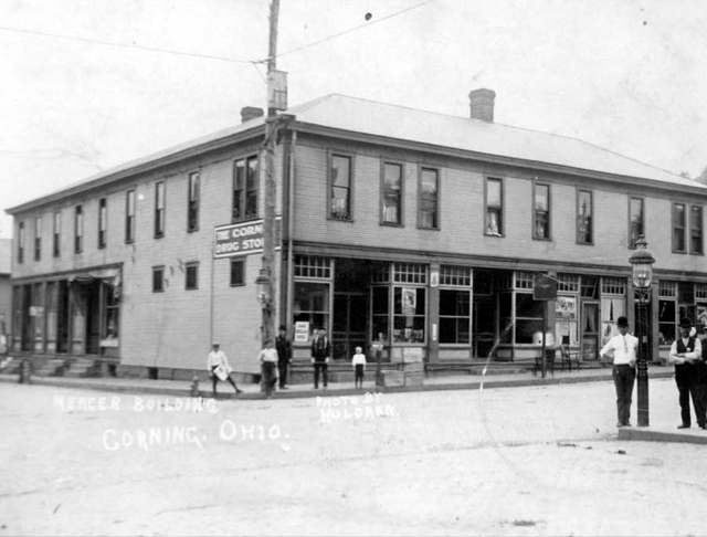
Photo: unknown photographer, local historical society collection, public domain (PD-1923) · Wikimedia Commons
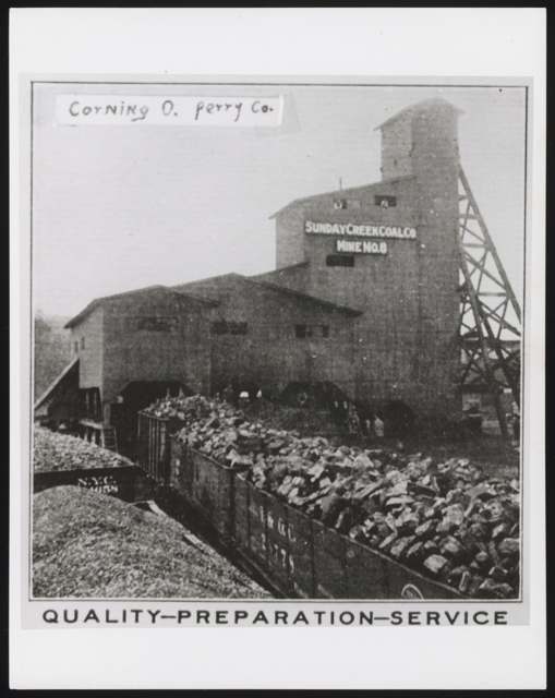
Photo: Frank Buhla Collection, Ohio University Libraries, via Digital Public Library of America, no known copyright restrictions · Wikimedia Commons
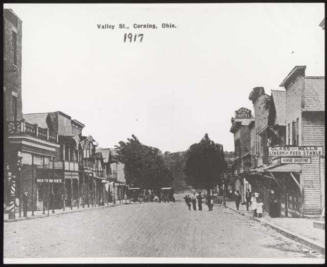
Photo: Ohio University Libraries, via Digital Public Library of America, no known copyright restrictions · Wikimedia Commons
Local history sources: en.wikipedia.org · archive.org · commons.wikimedia.org · commons.wikimedia.org · commons.wikimedia.org · archive.org
Water
Mostly private wells The water here
- Corning, Village Of47% of residentsHocking River Buried Valley Aquifer (wells)
- Southern Perry Co-hemlock20% of residentsHocking River Buried Valley Aquifer (wells)
- Southern Perry Co-buckingham15% of residentsHocking River Buried Valley Aquifer (wells)
- Southern Perry Co-congo10% of residentsHocking River Buried Valley Aquifer (wells)
- Portersville East Branch Water Co.6% of residentsHocking River Buried Valley Aquifer (wells)
- Oakdale Water District3% of residentsHocking River Buried Valley Aquifer (wells)
Hospitals, fire stations and more
Inside Corning's boundary: 1 fire or EMS station, 1 library, 1 police station and 1 spill case. Press a pin or a name for its whole record and its source.
Fire and EMS stations (1)
-
Corning Fire DepartmentCorning
- Address
- 107 East Main Street, Corning, OH 43730
- Coordinates
- 39.60235, -82.08755
USGS National Map structures (source) ↗ Street map and directions ↗
Source: USGS National Map structures (most Ohio records last updated 2019 to 2022), checked against the Columbus and Cleveland station lists. The department that answers a call is set by jurisdiction and mutual aid, not by distance.
Public libraries (1)
-
Corning BranchBranch · Corning
- Address
- 113 Eleventh Hill St, Corning, OH 43730
- What it is
- Branch
- Library system
- Perry County District Library
- Open
- 1,040 hours a year, 52 weeks
- Building
- 2,197 sq ft
- System's visits, FY2024
- 84,708
- System's loans, FY2024
- 194,470
- People the system serves
- 34,633
- Phone
- (740) 347-4763
IMLS Public Libraries Survey (source) ↗ Street map and directions ↗
Source: IMLS Public Libraries Survey FY2024 (outlets and their systems). Any Ohio resident can get a free card at any Ohio public library.
Police stations (1)
-
Corning Village Police DepartmentCorning
- Address
- 115 Corning Avenue, Corning, OH 43730
- Coordinates
- 39.60090, -82.08599
USGS National Map structures (source) ↗ Street map and directions ↗
Source: USGS National Map structures, police stations, corrected and completed by hand (September 2026). The department that answers a call is set by jurisdiction, not by distance.
Spills reported since 2021 (1)
-
Solid Waste Nos (Not Specified)2026-07-25 · Corning
- Reported
- 2026-07-25
- What spilled
- Solid Waste Nos (Not Specified)
- Where
- Corning, Perry County
- Ohio EPA district office
- SEDO
- Ohio EPA case number
- 2607EPA0001358
Ohio EPA spill reports (source) ↗ Street map and directions ↗
Source: Ohio EPA emergency response spill reports, 2021 to September 2026, one point per case where Ohio EPA placed it. A report is what the caller or responder recorded; amounts are often blank or estimated.
Its ZIP codes
Each ZIP code that touches Corning, with the share of its residents who live here and the same headline figures as the ZIP page.
| ZIP | Share | Water | Radon | Home value | Schools | Flood |
|---|---|---|---|---|---|---|
| 43730 Monroe Township and Corning | 21% | Mostly private wells | Too few radon tests | Median year built 1968 | Southern Local · 3.5 stars overall | 2.0% of residents in the 1% floodplain |
The county
Perry County: 11 ZIP codes, 26 cities, villages and townships, 38,855 people.
Nearby places
Rain and snow
How much has actually fallen on Corning, day by day, from 1887 to now. Daily totals, not averages.
- rain, last 30 days
- 1.90 in
- 2026-09-30 to 2026-10-29
- rain so far in 2026
- 47.6 in
- 11.0 in above normal for the date
- snow so far in 2026
- 17.9 in
- a normal year brings 17.8 in
- a normal year
- 43.0 in
- average of 30 years, 1991-2020
| Month | Rain (in) | Snow (in) | Days counted |
|---|---|---|---|
| October 2026 | 1.90 | — | 29 |
| September 2026 | 7.78 | — | 30 |
| August 2026 | 10.73 | — | 31 |
| July 2026 | 4.75 | — | 31 |
| June 2026 | 4.41 | — | 30 |
| May 2026 | 5.42 | — | 31 |
| April 2026 | 3.30 | — | 30 |
| March 2026 | 6.27 | 3.7 | 31 |
| February 2026 | 0.95 | 3.5 | 28 |
| January 2026 | 2.10 | 10.7 | 31 |
| December 2025 | 2.09 | 8.2 | 31 |
| November 2025 | 2.58 | 0.8 | 30 |
| Wettest year | 2018 — 61.8 in |
|---|---|
| Driest year | 1930 — 21.7 in |
| Snowiest year | 1917 — 54.0 in |
| Wettest day on record | 9 September 2004 — 4.25 in |
| Heaviest snowfall in a day | 14 January 1968 — 14.30 in |
| Deepest snow on the ground | 15 January 1968 — 21.80 in |
Estimated, not measured. No rain gauge has ever stood inside Corning, so every figure here is worked out from the gauges around it - the nearest ones weighted most. Treat them as close estimates rather than readings.
49,720 days of records, 1887-08-01 to 2026-10-29. Source: NOAA NCEI GHCN-Daily, 3,240 gauges in and around Ohio. A day is "gauged" when a gauge standing inside the boundary reported it, and the value is the mean of those gauges. Otherwise it is interpolated by inverse distance from every gauge reporting within 50 miles. Nothing is carried forward, back-filled or smoothed. Against NOAA nClimDiv county monthly precipitation over 136,848 complete county-months (checked 2026-10-31): correlation 0.9515, median absolute difference 0.217 in a month. Built 2026-10-31 from the Cracked Buckeye precipitation archive. Snow is the softer number — snowfall is measured by hand with a ruler, no agency publishes a gridded county snowfall series, and blowing snow defeats every observer.
Environmental permits and filings
What Ohio EPA has on file for Corning: permits, inspections, violations, cleanups and the state loans behind sewer and water work. Every line links to the agency's own document.
- facilities and sites on file
- 4
- those placed on the map inside Corning
| Program | Facilities and sites |
|---|---|
| Public drinking water | 4 |
| Date | Facility or site | What |
|---|---|---|
| SOUTHERN PERRY CO-MILLERTOWN PWS | Public drinking water report | |
| SOUTHERN PERRY CO-BUCKINGHAM PWS | Public drinking water report | |
| SOUTHERN PERRY CO-HEMLOCK PWS | Public drinking water report | |
| SOUTHERN PERRY CO-CONGO PWS | Public drinking water report | |
| SOUTHERN PERRY CO-CONGO PWS | Public drinking water plan | |
| SOUTHERN PERRY CO-CONGO PWS | Public drinking water plan | |
| SOUTHERN PERRY CO-CONGO PWS | Public drinking water report | |
| SOUTHERN PERRY CO-CONGO PWS | Public drinking water notice of violation | |
| SOUTHERN PERRY CO-CONGO PWS | Public drinking water plan | |
| SOUTHERN PERRY CO-CONGO PWS | Public drinking water plan | |
| SOUTHERN PERRY CO-MILLERTOWN PWS | Public drinking water report | |
| SOUTHERN PERRY CO-HEMLOCK PWS | Public drinking water report | |
| SOUTHERN PERRY CO-CONGO PWS | Public drinking water report | |
| SOUTHERN PERRY CO-BUCKINGHAM PWS | Public drinking water report | |
| SOUTHERN PERRY CO-CONGO PWS | Public drinking water plan | |
| SOUTHERN PERRY CO-CONGO PWS | Public drinking water plan | |
| SOUTHERN PERRY CO-CONGO PWS | Public drinking water plan | |
| SOUTHERN PERRY CO-CONGO PWS | Public drinking water plan | |
| SOUTHERN PERRY CO-MILLERTOWN PWS | Public drinking water compliance letter | |
| SOUTHERN PERRY CO-HEMLOCK PWS | Public drinking water compliance letter | |
| SOUTHERN PERRY CO-CONGO PWS | Public drinking water compliance letter | |
| SOUTHERN PERRY CO-BUCKINGHAM PWS | Public drinking water compliance letter | |
| SOUTHERN PERRY CO-MILLERTOWN PWS | Public drinking water inspection | |
| SOUTHERN PERRY CO-HEMLOCK PWS | Public drinking water inspection | |
| SOUTHERN PERRY CO-BUCKINGHAM PWS | Public drinking water inspection |
Source: Ohio EPA eDocument portal (edocpub.epa.ohio.gov), indexed 2026-10-14. Facilities are placed on the map from Ohio EPA's own map layers, EPA's Facility Registry, coordinates written in the filings, or a geocoded street address. A permit filed under a private person's name (most are household septic systems) is counted but never named, placed or linked; licenses for individual workers and open-burning notices are left out entirely.
Quick answers
What county is Corning, Ohio in?
Corning is a village in Perry County, Ohio, with 488 residents.
When was Corning, Ohio founded?
Corning was laid out 1878. Founders on record: Joseph Rodgers. Source
What ZIP code is Corning, Ohio?
Most of Corning is in ZIP code 43730.
Where does Corning, Ohio get its water?
The main water source for Corning (Corning, Village Of): Mostly private wells.
Cite this page
Cite this page as:
Cracked Buckeye, "Corning, Perry County", https://crackedbuckeye.com/place/corning/, built 2026-10-31, accessed [date].
How to cite · Report a correction · Built 2026-10-31
