Local events in Chatfield
Nothing is posted for Chatfield itself yet; here is what is on within 20 miles. All local events in Chatfield
Know a calendar we should watch? Send the link
Checked October 20; the events page is refreshed daily.
How Chatfield began
Chatfield was founded by pioneers Silas and Oliver Chatfield in the 1820s along the Sandusky Turnpike in northwestern Crawford County, on land that had been Wyandot hunting ground and included a large cranberry bog to the east. Growth was slow — the settlement was not really a community until around 1825 — and the surrounding swamp forest was later drained into the farmland that surrounds the village today. A state historical marker commemorating the village was placed in 1976.
Settled c. 1820, by Silas and Oliver Chatfield.
Where the name comes from
Named for pioneer settlers Silas and Oliver Chatfield, who established the settlement in the 1820s.
Before the town
For centuries before settlement, the area that became Chatfield was used by Native people as a hunting ground; Indian hunting camps are recorded on the headwaters of Sycamore Creek nearby. A large cranberry bog covered much of the land to the east, within a swamp forest of elm, ash, beech, pin oak and maple that shaped both Native use of the land and its slow settlement afterward. No specific village, trail or mound at Chatfield itself is named in the sources checked; the historic nation associated with hunting in this part of Crawford County is the Wyandot.
Nations recorded here: Wyandot.
Timeline
- — Crawford County opened to settlement (Maumee Valley land opened February 20, 1820); the nucleus settlement at Chatfield dates to this period.
- — The Chatfield settlement, founded by Silas and Oliver Chatfield along the Sandusky Turnpike, grew large enough to be considered a community.
- — Silas and Oliver Chatfield, English-descended brothers after whom the township was probably named, though the 1881 history says this is not definitely known, build cabins on the Columbus & Sandusky Turnpike.
- — Settlers, mostly of English descent from eastern counties, enter land along the Sandusky Turnpike, among them Richard Davidson, David Tipton, John Robinson, John Hamilton, David Clute and Ichabod Smith; the road gives them an outlet north and south.
- — Richard Frisbee and Nathan Anthony open separate taverns on the turnpike about a mile north of Richville, serving droves of hogs and cattle and wagons of grain bound for the lake ports; Garton Frisbee follows in 1833.
- — Silas Chatfield is elected a township trustee and Oliver treasurer; on November 11 the trustees divide the township into three school districts.
- — Settlers from Germany begin arriving in numbers about now, taking up all the township's land within about half a dozen years.
- — Chatfield's school district merged with Tiro and New Washington to form Buckeye Central Local School District.
- — A historical marker commemorating the village of Chatfield was erected by the Crawford County Historical Foundation and the Ohio Historical Society.
- — The census counts 218 people in Chatfield, 189 in 2010 and 205 in 2020.
Stories
A bog, a turnpike, and two brothers
Before the 1820s, the land where Chatfield now sits was a swamp forest of elm, ash, beech, pin oak and maple, with a cranberry bog to the east that stood under water most of the year, and it served as hunting ground worked by Native people camped along the headwaters of Sycamore Creek. Pioneers Silas and Oliver Chatfield settled the spot along the new Sandusky Turnpike in the 1820s, but growth came slowly; the marker placed on the site in 1976 records that it took roughly five years, until about 1825, before the little settlement could really call itself a community. Later generations drained the swamp and the bog into the flat, productive farmland that surrounds the village today.
Photographs
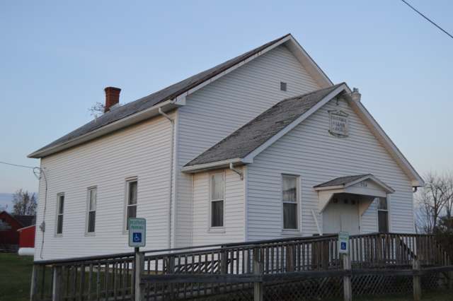
Photo: Nyttend, public domain · Wikimedia Commons
Local history sources: remarkableohio.org · en.wikipedia.org · en.wikipedia.org · commons.wikimedia.org · archive.org
Water
Mostly private wells The water here
- Bloomville Village100% of residentsGroundwater wells (2 wells)
Hospitals, fire stations and more
Inside Chatfield's boundary: 1 fire or EMS station. Press a pin or a name for its whole record and its source.
Fire and EMS stations (1)
-
Chatfield Fire DepartmentBloomville
- Address
- 3550 Chatfield Center Road, Bloomville, OH 44818
- Coordinates
- 40.95063, -82.94203
USGS National Map structures (source) ↗ Street map and directions ↗
Source: USGS National Map structures (most Ohio records last updated 2019 to 2022), checked against the Columbus and Cleveland station lists. The department that answers a call is set by jurisdiction and mutual aid, not by distance.
Its ZIP codes
Each ZIP code that touches Chatfield, with the share of its residents who live here and the same headline figures as the ZIP page.
| ZIP | Share | Water | Radon | Home value | Schools | Flood |
|---|---|---|---|---|---|---|
| 44825 Chatfield | 100% | Mostly private wells | Too few radon tests | Median year built 1928 | Buckeye Central Local · 4 stars overall | 0.0% of residents in the 1% floodplain |
| 44818 Bloomville | 2% | Mostly private wells | 10.1 pCi/L average radon | Median year built 1920 | Buckeye Central Local · 4 stars overall | 2.0% of residents in the 1% floodplain |
Local government
Who holds office in Chatfield, how its elections and ballot issues came out, and the state auditor's record.
Ballot issues
| Date | Issue | For | Against | Result |
|---|---|---|---|---|
| 2024-11-05 | Issue 4: VILLAGE OF CHATFIELD | 50 | 25 | Passed (66.67% for), unofficial |
| 2020-11-03 | Issue 1: VILLAGE OF CHATFIELD (RENEWAL) | 48 | 21 | Passed (69.57% for) |
Elections for office
| Date | Office | Candidates and votes |
|---|---|---|
| 2023-11-07 | Member of Council | Norman Garland 52, 51.49%; Robert E. Schiefer 49, 48.51% |
| 2023-11-07 | Mayor | Scott Bishop 54, 100.0% |
| 2023-11-07 | Clerk-Treasurer | Jamie Bishop 54, 100.0% |
| 2021-11-02 | Member of Council | Michael Alonzo 32, 35.16%; Charles M. Brose 31, 34.07%; Donna Peterman 28, 30.77% |
| 2019-11-05 | Member of Council | Robert E. Schiefer 21, 80.77%; Write-In: Norman Garland 5, 19.23% |
| 2019-11-05 | Mayor | Scott Bishop 21, 100.0% |
| 2019-11-05 | Clerk-Treasurer | Jamie Bishop 22, 100.0% |
Winners in bold. Results from the county board of elections' official canvass unless marked.
Auditor of State record
- No fiscal caution, watch or emergency on the Auditor of State's lists.
- Basic Audit, 2024 to 2025, released 2026-08-13
- Basic Audit, 2022 to 2023, released 2024-08-13
The county
Crawford County: 8 ZIP codes, 22 cities, villages and townships, 43,874 people.
Nearby places
Rain and snow
How much has actually fallen on Chatfield, day by day, from 1892 to now. Daily totals, not averages.
- rain, last 30 days
- 1.31 in
- 2026-09-30 to 2026-10-29
- rain so far in 2026
- 36.9 in
- 2.9 in above normal for the date
- snow so far in 2026
- 21.0 in
- a normal year brings 29.3 in
- a normal year
- 40.0 in
- average of 30 years, 1991-2020
| Month | Rain (in) | Snow (in) | Days counted |
|---|---|---|---|
| October 2026 | 1.31 | — | 29 |
| September 2026 | 4.72 | — | 30 |
| August 2026 | 5.40 | — | 31 |
| July 2026 | 2.68 | — | 31 |
| June 2026 | 4.14 | — | 30 |
| May 2026 | 5.46 | — | 31 |
| April 2026 | 7.30 | — | 30 |
| March 2026 | 4.13 | 0.5 | 31 |
| February 2026 | 0.56 | 4.1 | 28 |
| January 2026 | 1.21 | 16.5 | 31 |
| December 2025 | 2.39 | 9.4 | 31 |
| November 2025 | 1.54 | 1.9 | 30 |
| Wettest year | 2011 — 56.8 in |
|---|---|
| Driest year | 1963 — 23.4 in |
| Snowiest year | 1893 — 76.0 in |
| Wettest day on record | 21 August 2007 — 5.89 in |
| Heaviest snowfall in a day | 23 December 2004 — 13.17 in |
| Deepest snow on the ground | 27 March 1896 — 19.02 in |
Estimated, not measured. No rain gauge has ever stood inside Chatfield, so every figure here is worked out from the gauges around it - the nearest ones weighted most. Treat them as close estimates rather than readings.
48,794 days of records, 1892-12-01 to 2026-10-29. Source: NOAA NCEI GHCN-Daily, 3,240 gauges in and around Ohio. A day is "gauged" when a gauge standing inside the boundary reported it, and the value is the mean of those gauges. Otherwise it is interpolated by inverse distance from every gauge reporting within 50 miles. Nothing is carried forward, back-filled or smoothed. Against NOAA nClimDiv county monthly precipitation over 136,848 complete county-months (checked 2026-10-31): correlation 0.9515, median absolute difference 0.217 in a month. Built 2026-10-31 from the Cracked Buckeye precipitation archive. Snow is the softer number — snowfall is measured by hand with a ruler, no agency publishes a gridded county snowfall series, and blowing snow defeats every observer.
Quick answers
What county is Chatfield, Ohio in?
Chatfield is a village in Crawford County, Ohio, with 205 residents.
When was Chatfield, Ohio founded?
Chatfield was settled c. 1820. Founders on record: Silas and Oliver Chatfield. Source
How did Chatfield, Ohio get its name?
Named for pioneer settlers Silas and Oliver Chatfield, who established the settlement in the 1820s. Source
What ZIP code is Chatfield, Ohio?
Most of Chatfield is in ZIP code 44825.
Where does Chatfield, Ohio get its water?
The main water source for Chatfield (Bloomville Village): Mostly private wells.
Cite this page
Cite this page as:
Cracked Buckeye, "Chatfield, Crawford County", https://crackedbuckeye.com/place/chatfield/, built 2026-10-31, accessed [date].
How to cite · Report a correction · Built 2026-10-31
