Local events in Cedarville
104 events in the next 90 days from 2 public calendars. All local events in Cedarville
Checked October 20; the events page is refreshed daily.
Notable Ohioans tied to Cedarville
Born, lived, worked or buried here, each with a sourced profile. All notable Ohioans
History from Cedarville
People and inventions tied to this place, each with its sources. All people · All inventions
How Cedarville began
Cedarville grew up on Massie's Creek in what became Cedarville Township, first settled by Kentucky and South Carolina families (many of them Covenanter Presbyterians who left slave states on principle) starting around 1801. A mill owner named Jesse Newport platted the town in 1816 and first called it Milford, but the name clashed with another Ohio Milford and was changed to Cedarville, for the cedars lining the creek, when the village got its first post office in the 1830s-40s. Limestone quarrying and lime manufacture were the township's chief industries by 1880. Cedarville College, chartered in 1887 by the New Light Reformed Presbyterian Church, later merged with a Baptist institute in 1953 and is today Cedarville University, the village's dominant employer and identity.
Settled 1799 per Wikipedia; the 1881 county history dates the township's first permanent white settlement (the Townsley brothers on Massie's Creek, first corn crop) to 1801, platted 1816, by Jesse Newport, by Jesse Newport (proprietor who platted the village).
Where the name comes from
The village was first called Milford by Newport because he had a mill close by, but with another Milford already in Ohio the post office could not be established under that name. The 1881 county history says the village was renamed Cedarville in 1834, for the cedar trees lining the banks of Massie's Creek, at about the time it got its own post office (first postmaster John Paris). Wikipedia instead dates a post office called 'Massies Creek' to 1837 and says the name Cedarville was adopted in 1843 - the two sources disagree on the exact year.
Before the town
Cedarville Township sits at the headwaters reach of Massie's Creek, a Little Miami tributary, in territory that lay within the Shawnee and Wyandot hunting range before the 1795 Treaty of Greenville opened most of this part of Ohio to American settlement. The 1881 county history records that when Alexander McCoy settled just west of the future village site in 1802, his six hundred acres were 'full of bears, wolves, deer, and nearly all kinds of small game, together with a tribe of Indians who had a camp upon the place,' adding that this group was peaceable and 'the first settlers never received at their hands anything but the kindest, and most humane treatment' - the tribe is not named. The same source repeats a local tradition that General Nathaniel Massie, for whom the creek is named, drove Native people 'under the famous chief Tecumseh' across the cliffs below Cedarville village years before white settlement; this claim is unverified, undated, and hard to reconcile with Tecumseh's own biography (he was a child in the 1770s-80s when Massie was surveying), so it should be treated as local legend rather than established fact. The one concrete, dated Native site in the area is Williamson Mound, a large Adena burial mound off U.S. Route 42 west of the village, now within Indian Mound Reserve; an 1881 description of an oval mound 'about forty feet high' in an open field a quarter mile below the Falls of Massie's Creek almost certainly refers to the same mound, though the source does not use the name Williamson. No other named villages, trails, or treaty lines specific to Cedarville were found.
Nations recorded here: Shawnee, Wyandot, Adena culture.
- Williamson Mound (Williamson Mound State Memorial / Indian Mound Reserve) (mound) — Off U.S. Route 42, west of Cedarville, Cedarville Township, Adena culture, roughly 500 BC - AD 100 (en.wikipedia.org)
Timeline
- — The Townsley brothers, John and Thomas, emigrate from Kentucky and settle on Massie's Creek, harvesting the township's first crop of corn raised by a white settler.
- — Alexander McCoy settles just west of the future village site; his land includes a peaceable Native encampment, unnamed in the record.
- — Jesse Newport plats the village, initially naming it Milford after his nearby mill.
- — The village is renamed Cedarville and gets its first post office, with John Paris as postmaster, per the 1881 county history (Wikipedia instead gives 1837 for a post office called Massies Creek and 1843 for the Cedarville name).
- — Cedarville Township is organized from portions of Xenia, Miami, and Ross townships.
- — Cedarville College is chartered by the New Light Reformed Presbyterian Church.
- — The Cedarville Opera House is built on Main Street, later housing the mayor, council, jail, fire and police departments, and waterworks offices on its ground floor.
- — The Harper Mausoleum and its Egyptian Revival memorial entrance are built in North Cemetery for George W. Harper, a wealthy Cedarville banker and landowner.
- — The Baptist Bible Institute of Cleveland relocates to Cedarville's campus, merging with the Presbyterian college and shifting it to Baptist affiliation.
- — Williamson Mound is listed on the National Register of Historic Places as Williamson Mound State Memorial.
- — The Whitelaw Reid House, birthplace of the journalist and diplomat, is listed on the National Register of Historic Places.
- — Cedarville College is elevated to university status, becoming Cedarville University.
Stories
The farm boy who edited the New York Tribune
Whitelaw Reid was born October 27, 1837, on his family's farm southwest of Cedarville, in a house built in 1823 that still stands at 2587 Conley Road. He attended Xenia Academy and graduated with honors from Miami University in 1856. Reid joined Horace Greeley's New-York Tribune in 1868 and became managing editor within a year; when Greeley died in 1872, Reid bought the paper and ran it until his own death. He served as U.S. Minister to France (1889-1892) and ran as Benjamin Harrison's vice-presidential candidate in 1892, then closed out his career as ambassador to the United Kingdom from 1905 until he died in London on December 15, 1912. His boyhood home, remodeled by Reid himself into a Queen Anne showpiece, was listed on the National Register in 1973 and later became the home of Ohio governor Mike DeWine.
A mound that outlasted its excavators
An 1881 description of the ground below the Falls of Massie's Creek, west of Cedarville, tells of an oval earthen mound about forty feet high, its slopes carrying trees a century old, from which a viewer could see for miles in every direction. The writer guessed it had been built by ancient people to watch for approaching enemies, and admitted plainly that 'to unravel the mystery of this earthen mound belongs to him who has made the study of pre-historic ages his life work.' Archaeologists later attributed such mounds in the region to the Adena culture, which built earthworks over burned mortuary structures as part of elaborate burial rites between roughly 500 BC and AD 100. The mound matching this description and location, now called Williamson Mound, sits in Indian Mound Reserve off U.S. 42 and was listed on the National Register of Historic Places in 1971.
From cattle drover to Egyptian Revival mausoleum
George W. Harper's family came to Greene County from Harpers Ferry, Virginia, in 1812, when he was still an infant. At eighteen he went into the cattle business in Illinois and built a fortune, then returned to Cedarville, married in 1860, and became one of the township's largest landowners, with roughly 1,100 acres by 1881. He ran the George W. Harper Banking Company until it was bought out in 1896, and around 1900 he and his wife gave $5,000 to endow an economics chair at Cedarville College. When Harper died, his family commissioned an Egyptian Revival mausoleum and matching cemetery gate from the George Dodd & Sons Granite Co., completed in 1915, with sphinxes, palm-leaf column capitals, a vulture-and-sun-disk cornice, and bronze doors cast with lotus flowers. Both structures were listed on the National Register of Historic Places in 1988.
Photographs
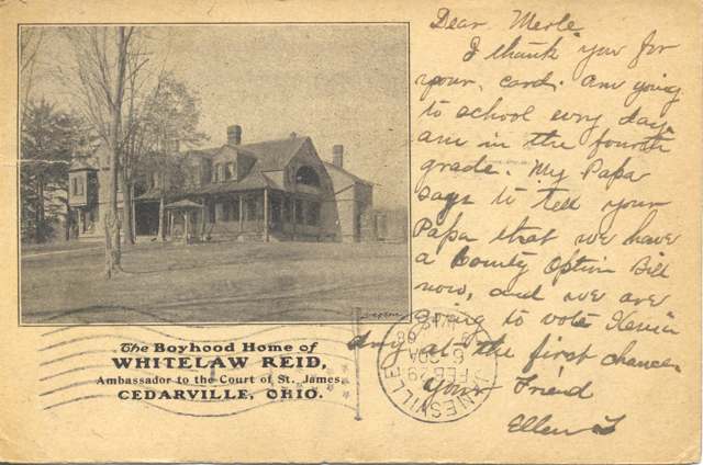
Photo: Miami University Libraries Digital Collections (Bowden Postcard Collection), via Flickr Commons, no known copyright restrictions · Wikimedia Commons
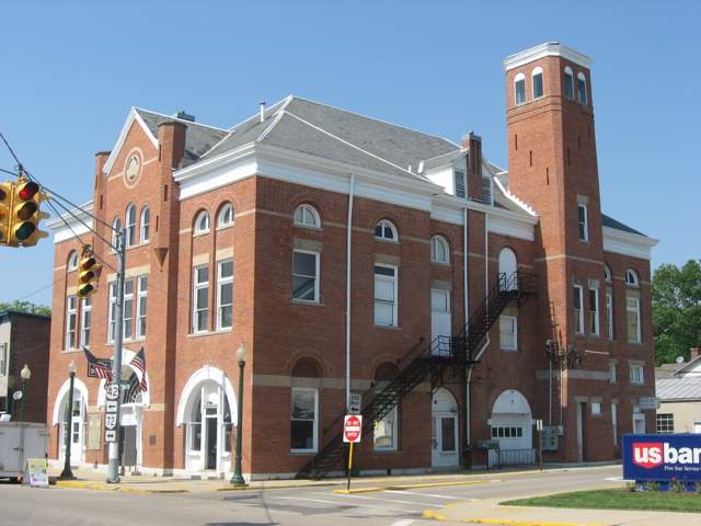
Photo: Nyttend, public domain · Wikimedia Commons
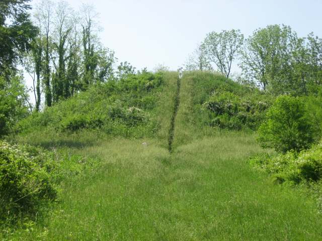
Photo: Nyttend, public domain · Wikimedia Commons
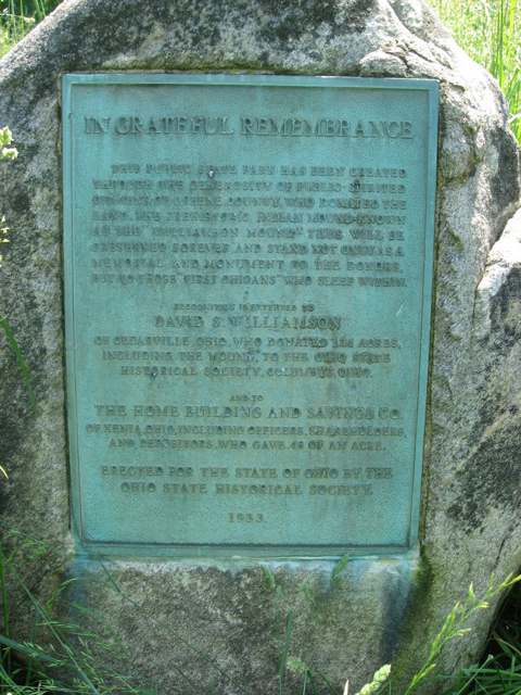
Photo: Nyttend, public domain · Wikimedia Commons
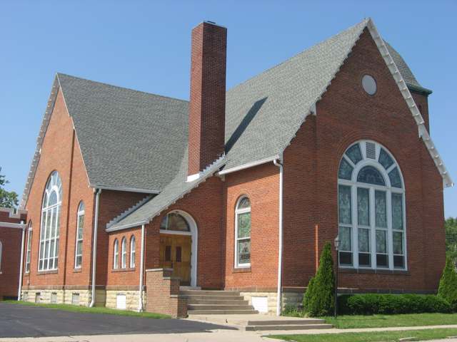
Photo: Nyttend, public domain · Wikimedia Commons
Local history sources: en.wikipedia.org · en.wikipedia.org · en.wikipedia.org · en.wikipedia.org · en.wikipedia.org · en.wikipedia.org · en.wikipedia.org · en.wikipedia.org · archive.org · commons.wikimedia.org · commons.wikimedia.org · commons.wikimedia.org · commons.wikimedia.org · commons.wikimedia.org
Historic places
2 places in Cedarville on the National Register of Historic Places. Press a pin or a name for its whole record.
-
Cedarville Opera HouseBuilding · Cedarville · listed 1984
- Address
- 78 N. Main St.
- Where
- Cedarville, Greene County · ZIP 45314
- What it is
- Building
- Listed on the National Register
- 1984
- NRIS reference number
- 84003697
- Coordinates
- 39.74187, -83.80682
National Register file (NPS) ↗ Search Wikipedia ↗ Street map and directions ↗ On the Cracked Buckeye map
-
Harper Mausoleum and Harper, George W., Memorial EntranceStructure · Cedarville · listed 1988
- Address
- North Cemetery, OH 72
- Where
- Cedarville, Greene County · ZIP 45314
- What it is
- Structure
- Listed on the National Register
- 1988
- NRIS reference number
- 88000115
- Coordinates
- 39.75417, -83.81228
National Register file (NPS) ↗ Search Wikipedia ↗ Street map and directions ↗ On the Cracked Buckeye map
Source: National Park Service, National Register of Historic Places point file. The listing year is shown where NPS's certification date agrees with the listing's reference number. Listing recognizes significance; it does not restrict a private owner.
Water
Groundwater wells (8 wells) The water here
- Cedarville University100% of residentsGroundwater wells (8 wells)
Hospitals, fire stations and more
Inside Cedarville's boundary: 1 fire or EMS station, 1 college, 1 power plant, 1 high-hazard dam, 2 public schools, 1 library, 1 police station, 1 public charging site and 1 Toxics Release Inventory facility. Press a pin or a name for its whole record and its source.
Fire and EMS stations (1)
-
Cedarville Township Volunteer Fire and Emergency Medical Services DepartmentCedarville
- Address
- 19 South Street, Cedarville, OH 45314
- Coordinates
- 39.74357, -83.80519
USGS National Map structures (source) ↗ Street map and directions ↗
Source: USGS National Map structures (most Ohio records last updated 2019 to 2022), checked against the Columbus and Cleveland station lists. The department that answers a call is set by jurisdiction and mutual aid, not by distance.
Colleges (1)
-
Cedarville UniversityPrivate nonprofit college · Cedarville
- What it is
- Private nonprofit college
- City
- Cedarville
- Students, 2023-24 (12-month count)
- 5,744
- Tuition and fees, in state
- $36,078
- Graduation rate
- 74% of bachelor's students, within six years (a class of 867)
- IPEDS unit ID
- 201654
College Navigator (NCES) ↗ IPEDS data (source) ↗ Street map and directions ↗
Source: NCES IPEDS 2024 directory, 2023-24 enrollment and tuition, graduation rates for the 2017 (four-year) and 2020 (two-year) entering classes.
Power plants (1)
-
CU Solar PlantSolar · 2 MW
- Capacity
- 2 MW
- Main source
- Solar
- Technology
- Solar Photovoltaic
- Operator
- CU Solar LLC
- Sector
- IPP Non-CHP
- Where
- Cedarville, Greene County
- Generating units
- 1
- Built
- 2013
- EIA plant code
- 58386
EIA plant page ↗ EIA-860 (source) ↗ Street map and directions ↗
Source: EIA-860 power plant inventory via HIFLD (February 2025), with plant codes, units and years from EIA-860 2025.
High-hazard dams (1)
-
Cedarville Upground Reservoir PoorMassies Creek - Offstream · condition: poor
- Hazard class
- High: a failure would probably cost a life
- Condition
- Poor (assessed 01/14/2025)
- River or stream
- Massies Creek - Offstream
- Type
- Earth
- Height
- 15 ft
- Storage
- 72 acre-feet
- Completed
- 1963
- Owner type
- Local Government
- County
- Greene County
- Nearest town (NID)
- Cedarville
- Last inspection
- 05/23/2024
- Emergency action plan
- No
- NID ID
- OH00807
National Inventory of Dams record ↗ National Inventory of Dams (source) ↗ Street map and directions ↗
Source: U.S. Army Corps of Engineers National Inventory of Dams, August 2026. "High hazard" rates what a failure would cost downstream, not how likely one is; the condition is the state's assessment.
Public schools (2)
-
Cedarville Elementary School4.5 of 5 stars · Cedarville
- Address
- 194 Walnut St, Cedarville, OH 45314
- School district
- Cedar Cliff Local School District
- Kind (NCES)
- Regular School
- Students, 2023-24
- 253
- Teachers (full-time equivalent)
- 16.03
- Report card, 2025-26
- 4.5 of 5 stars
- Performance index
- 93.3%
- Ohio building IRN
- 005165
- NCES school ID
- 390472502820
NCES school record ↗ Ohio School Report Card ↗ Street map and directions ↗
-
Cedarville High School4.5 of 5 stars · Cedarville
- Address
- 194 Walnut St, Cedarville, OH 45314
- School district
- Cedar Cliff Local School District
- Kind (NCES)
- Regular School
- Students, 2023-24
- 329
- Teachers (full-time equivalent)
- 15.76
- Report card, 2025-26
- 4.5 of 5 stars
- Performance index
- 86.2%
- Four-year graduation rate
- 95.6%
- Ohio building IRN
- 005173
- NCES school ID
- 390472502821
NCES school record ↗ Ohio School Report Card ↗ Street map and directions ↗
Source: NCES EDGE public school locations 2024-25 and Common Core of Data 2023-24 (type, students, teachers); Ohio School Report Cards 2025-26 (Department of Education and Workforce), matched by name within the district.
Public libraries (1)
-
Cedarville Branch LibraryBranch · Cedarville
- Address
- 20 S. Miller St., Cedarville, OH 45314
- What it is
- Branch
- Library system
- Greene County Public Library
- Open
- 2,860 hours a year, 52 weeks
- Building
- 5,000 sq ft
- System's visits, FY2024
- 427,596
- System's loans, FY2024
- 2,831,847
- People the system serves
- 167,966
- Phone
- (937) 352-4006
IMLS Public Libraries Survey (source) ↗ Street map and directions ↗
Source: IMLS Public Libraries Survey FY2024 (outlets and their systems). Any Ohio resident can get a free card at any Ohio public library.
Police stations (1)
-
Cedarville Police DepartmentCedarville
- Address
- 14 East Xenia Avenue, Cedarville, OH 45314
- Coordinates
- 39.74181, -83.80693
USGS National Map structures (source) ↗ Street map and directions ↗
Source: USGS National Map structures, police stations, corrected and completed by hand (September 2026). The department that answers a call is set by jurisdiction, not by distance.
Public EV charging (1)
-
Cedarville University - Wood Hall4 Level 2 · Cedarville
- Address
- 251 N Main St, Cedarville, OH 45314
- Ports
- 4 Level 2
- Plugs
- J1772
- Network
- Non-Networked
- Hours
- 24 hours daily
- Phone
- 937-766-7700
Station Locator (NREL) ↗ Alternative Fuels Data Center (source) ↗ Street map and directions ↗
Source: NREL Alternative Fuels Data Center station list (May 2026), public and open stations, the posts at one address counted as one site.
Facilities reporting toxic releases (1)
-
Pyrograf Products IncToxics Release Inventory · Cedarville
- Address
- 154 W Xenia Ave, Cedarville, OH 45314
- County
- Greene County
- Status
- Reports to the Toxics Release Inventory
- EPA program ID
- 4531WPYRGR154WX
- EPA registry ID
- 110019898850
EPA facility record ↗ EPA Facility Registry Service (source) ↗ Street map and directions ↗
Source: EPA Facility Registry Service, Toxics Release Inventory reporters. Reporting a release is required of large users of listed chemicals; it is not by itself a violation.
Its ZIP codes
Each ZIP code that touches Cedarville, with the share of its residents who live here and the same headline figures as the ZIP page.
| ZIP | Share | Water | Radon | Home value | Schools | Flood |
|---|---|---|---|---|---|---|
| 45314 Cedarville | 68% | Groundwater wells (8 wells) | 5.9 pCi/L average radon | Median year built 1972 | Cedar Cliff Local · 4.5 stars overall | 4.6% of residents in the 1% floodplain |
Local government
How its elections and ballot issues came out and the state auditor's record.
Money issues on the ballot since 2017: 3 of 3 passed.
Ballot issues
| Date | Issue | For | Against | Result |
|---|---|---|---|---|
| 2023-05-02 | Issue: 11-Village of Cedarville #1 | 49 | 22 | Passed (69.01% for) |
| 2023-05-02 | Issue: 12-Village of Cedarville - Electrical Aggregation | 51 | 20 | Passed (71.83% for) |
| 2023-05-02 | Issue: 13-Village of Cedarville - Natural Gas Aggregation | 50 | 21 | Passed (70.42% for) |
| 2021-11-02 | Issue: Cedarville Village Current Tax Levy #16 (levy type not on the results report) | 195 | 56 | Passed (77.69% for) |
| 2020-11-03 | Issue: Cedarville Village – Income Tax #2 | 547 | 288 | Passed (65.51% for) |
| 2017-11-07 | Issue: 6 - Cedarville Village Income Tax | 280 | 93 | Passed (75.07% for) |
Elections for office
| Date | Office | Candidates and votes |
|---|---|---|
| 2021-11-02 | Member of Council | John Cody Jr. 184, 32.74%; Guy Darren Dawes 181, 32.21%; Harold L. Stancliff 197, 35.05% |
| 2019-11-05 | Mayor | Tony Pergram 213, 100.0% |
| 2019-11-05 | Council | David Brooks 158, 40.2%; Matthew McNelly 108, 27.48%; Michael Terrell 127, 32.32% |
| 2017-11-07 | Council | Douglas W. Chisholm 302, 30.69%; Richard C. Fouts 166, 16.87%; Marilyn L. Ware 294, 29.88% |
Winners in bold. Results from the county board of elections' official canvass unless marked. The county's results on file run through 2025-05-06; later elections are not loaded yet.
Auditor of State record
- No fiscal caution, watch or emergency on the Auditor of State's lists.
- Agreed Upon Procedures, 2023 to 2024, released 2025-11-06
On the November 3, 2026 ballot
Statewide question: State Issue 3: Voter ID
Local questions for Cedarville, Greene County and its school district:
- Cedarville Village: Renews a 2.6-mill property tax levy for the current expenses of Cedarville Village for 5 years, beginning in 2026.
- Greene County: Renews a 0.25-mill property tax levy for the bridges of Greene County for 5 years, beginning in 2026.
Races, candidates and every question for an address: your ballot. County offices and judges are on your county board's sample ballot.
The county
Greene County: 17 ZIP codes, 23 cities, villages and townships with pages here, 174,322 people (Census Bureau estimate, July 2025).
Nearby places
Rain and snow
How much has actually fallen on Cedarville, day by day, from 1893 to now. Daily totals, not averages.
- rain, last 30 days
- 0.86 in
- 2026-10-02 to 2026-10-31
- rain so far in 2026
- 44.6 in
- 7.5 in above normal for the date
- snow so far in 2026
- 18.7 in
- a normal year brings 20.9 in
- a normal year
- 43.0 in
- average of 29 years, 1991-2020
| Month | Rain (in) | Snow (in) | Days counted |
|---|---|---|---|
| October 2026 | 0.86 | — | 31 |
| September 2026 | 6.15 | — | 30 |
| August 2026 | 8.84 | — | 31 |
| July 2026 | 2.35 | — | 31 |
| June 2026 | 3.52 | — | 30 |
| May 2026 | 8.35 | — | 31 |
| April 2026 | 3.89 | — | 30 |
| March 2026 | 6.76 | 0.6 | 31 |
| February 2026 | 2.64 | 4.1 | 28 |
| January 2026 | 1.27 | 14.1 | 31 |
| December 2025 | 2.55 | 9.5 | 31 |
| November 2025 | 2.50 | 3.6 | 30 |
| Wettest year (estimated) | 2011 — 63.0 in |
|---|---|
| Driest year (estimated) | 1901 — 24.8 in |
| Snowiest year (estimated) | 1920 — 51.7 in |
| Wettest day (estimated) | 4 July 1975 — 4.84 in |
| Heaviest snowfall in a day (estimated) | 19 March 1896 — 12.01 in |
| Deepest snow on the ground (estimated) | 21 January 1978 — 22.01 in |
Estimated, not measured. No rain gauge has ever stood inside Cedarville, so every figure here is worked out from the gauges around it - the nearest ones weighted most. Treat them as close estimates rather than readings.
47,689 days of records, 1893-01-01 to 2026-10-31. Source: NOAA NCEI GHCN-Daily, 3,240 gauges in and around Ohio. A day is "gauged" when a gauge standing inside the boundary reported it, and the value is the mean of those gauges. Otherwise it is interpolated by inverse distance from every gauge reporting within 50 miles. Nothing is carried forward, back-filled or smoothed. Against NOAA nClimDiv county monthly precipitation over 136,848 complete county-months (checked 2026-11-02): correlation 0.9515, median absolute difference 0.217 in a month. Built 2026-11-02 from the Cracked Buckeye precipitation archive. Snow is the softer number — snowfall is measured by hand with a ruler, no agency publishes a gridded county snowfall series, and blowing snow defeats every observer.
Environmental permits and filings
What Ohio EPA has on file for Cedarville: permits, inspections, violations, cleanups and the state loans behind sewer and water work. Every line links to the agency's own document.
- facilities and sites on file
- 9
- those placed on the map inside Cedarville
| Program | Facilities and sites |
|---|---|
| Hazardous waste | 2 |
| Wastewater and stormwater discharge | 2 |
| Air pollution | 1 |
| Composting | 1 |
| Landfills | 1 |
| Public drinking water | 1 |
| Sewer and water-line construction | 1 |
| Date | Facility or site | What |
|---|---|---|
| CEDARVILLE LANDFILL | Landfills monitoring results | |
| CEDARVILLE UNIVERSITY PWS | Public drinking water compliance letter | |
| CEDARVILLE LANDFILL | Landfills plan | |
| CEDARVILLE LANDFILL | Landfills inspection | |
| CEDARVILLE UNIVERSITY PWS | Public drinking water monitoring results | |
| CEDARVILLE LANDFILL | Landfills report | |
| CEDARVILLE LANDFILL | Landfills inspection | |
| CEDARVILLE LANDFILL | Landfills plan | |
| CEDARVILLE LANDFILL | Landfills inspection | |
| CEDARVILLE LANDFILL | Landfills report | |
| CEDARVILLE UNIVERSITY PWS | Public drinking water report | |
| CEDARVILLE UNIVERSITY PWS | Public drinking water plan | |
| CEDARVILLE UNIVERSITY PWS | Public drinking water inspection | |
| CEDARVILLE COMPOSTING FACILITY | Composting inspection | |
| CEDARVILLE LANDFILL | Landfills inspection | |
| CEDARVILLE COMPOSTING FACILITY | Composting report | |
| CEDARVILLE LANDFILL | Landfills report | |
| CEDARVILLE LANDFILL | Landfills inspection | |
| CEDARVILLE LANDFILL | Landfills report | |
| CEDARVILLE LANDFILL | Landfills compliance letter | |
| CEDARVILLE UNIVERSITY PWS | Public drinking water notice of violation | |
| CEDARVILLE UNIVERSITY PWS | Public drinking water inspection | |
| CEDARVILLE LANDFILL | Landfills inspection | |
| CEDARVILLE LANDFILL | Landfills inspection | |
| CEDARVILLE LANDFILL | Landfills plan |
Source: Ohio EPA eDocument portal (edocpub.epa.ohio.gov), indexed 2026-10-14. Facilities are placed on the map from Ohio EPA's own map layers, EPA's Facility Registry, coordinates written in the filings, or a geocoded street address. A permit filed under a private person's name (most are household septic systems) is counted but never named, placed or linked; licenses for individual workers and open-burning notices are left out entirely.
Quick answers
What county is Cedarville, Ohio in?
Cedarville is a village in Greene County, Ohio, with 4,257 residents.
When was Cedarville, Ohio founded?
Cedarville was settled 1799 per Wikipedia; the 1881 county history dates the township's first permanent white settlement (the Townsley brothers on Massie's Creek, first corn crop) to 1801; laid out 1816, by Jesse Newport. Founders on record: Jesse Newport (proprietor who platted the village). Source
How did Cedarville, Ohio get its name?
The village was first called Milford by Newport because he had a mill close by, but with another Milford already in Ohio the post office could not be established under that name. Source
What ZIP code is Cedarville, Ohio?
Most of Cedarville is in ZIP code 45314.
Where does Cedarville, Ohio get its water?
The main water source for Cedarville (Cedarville University): Groundwater wells (8 wells).
Cite this page
Cite this page as:
Cracked Buckeye, "Cedarville, Greene County", https://crackedbuckeye.com/place/cedarville/, built 2026-11-02, accessed [date].
How to cite · Report a correction · Built 2026-11-02