Local events in Blakeslee
Nothing is posted for Blakeslee itself yet; here is what is on within 10 miles. All local events in Blakeslee
Know a calendar we should watch? Send the link
Checked October 20; the events page is refreshed daily.
How Blakeslee began
Blakeslee is a railroad town in southern Florence Township. In November 1880, John Boman, who had lived on the site since 1853, laid out fifty-six lots there and named the village for Schuyler E. Blakeslee, a Bryan lawyer. The post office opened that May, and residents gave the railroad depot grounds, right of way and about $1,000 to secure a station on what became the Wabash line southwest of Montpelier. The village incorporated in 1894 and reached its peak of 239 people in 1900. The 1920 county history remembers it as the last place in Williams County with an open saloon. The 2020 census counted 104 residents.
Settled 1853 (John Boman on the village site), platted November 1880, incorporated 1894, by John Boman.
Where the name comes from
Named by John Boman for S. E. (Schuyler E.) Blakeslee, whom the 1882 county history calls a lawyer and 'distinguished citizen' of Bryan. The same Blakeslee defended Andrew J. Tyler at the 1848 trial for the murder of David Schamp, a case recounted in the Jefferson Township file.
Before the town
No Native village, trail or treaty site inside Blakeslee is recorded in the sources checked. For Florence Township, the 1920 county history records that Margaret Singer, an early settler, said that for three years after she and her husband settled she saw no other white person and their only visitors were Native people. The 1817 Treaty of the Maumee Rapids had transferred Indian title to this part of northwestern Ohio to the United States more than six decades before Blakeslee was platted.
Timeline
- — In April, John Boman begins living on the land that becomes the village.
- — St. Joseph Catholic Church is built north of the future village for about $4,000 by a congregation that starts with seven families. The 1882 history dates it about seventeen years earlier.
- — On May 4, the Blakeslee post office is established with John N. Chilcote as first postmaster.
- — In November, John Boman lays out fifty-six lots on Section 34 of Florence Township and names the village for S. E. Blakeslee of Bryan. J. N. Chilcote builds the second house in October and has the first stock of goods.
- — Chilcote and Somerlott build a sawmill in February, and James Fitzgerald opens a lumber yard. Residents give the railroad company depot grounds, right of way and about $1,000.
- — The first school term in the village is taught in the summer in Peter Hewart's building. Each pupil pays the teacher 75 cents for the three-month term.
- — Additions of eighteen lots in December and Conrad Sachar's thirty-six lots in November enlarge the plat.
- — An arsonist burns St. Joseph Catholic Church and is sent to the penitentiary for fifteen years. By 1882 the parish, now about fifty families, is building a brick church on the site expected to cost about $8,000.
- — Blakeslee incorporates as a village.
- — The Blakeslee town plat is printed on sheet 20 of the Atlas of Williams County, Ohio.
- — Population peaks at 239. The 1905 county history describes Blakeslee as a trade center on the Wabash railroad ten miles southwest of Montpelier.
- — The county history records that the open saloon had been banished from Blakeslee, the last place in the county to have one.
- — The census records 104 residents, a 56 percent decline from the village's 1900 peak.
Stories
A depot bought by the village
Blakeslee existed because of the railroad. John Boman had farmed the site since 1853, and in November 1880 he laid out fifty-six lots and named them for the Bryan lawyer S. E. Blakeslee. Within a year the village had J. N. Chilcote's store, Theodore Long's store, two groceries, a hotel kept by J. F. Snyder, a sawmill and a lumber yard. To secure a station, residents gave the railroad company the depot grounds and right of way and raised about $1,000 in cash. By 1882 G. H. Meredith was station agent. The 1905 county history places the village on the Wabash, ten miles southwest of Montpelier.
The last oasis
The 1920 county history says Edon was among the first 'dry' communities in Williams County, while Blakeslee was the last 'oasis in the desert.' People came from many miles to Blakeslee's saloons, and according to that history, citizens grew tired of seeing so much drunkenness on the county's roads. Blakeslee stayed 'on the map of the wet world' after the dry towns were no longer destinations for drinkers, until the open saloon was finally banished there too. The history does not give the year.
Photographs
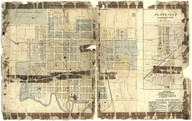
Photo: J. M. Lathrop and John C. Grim; Library of Congress, Geography and Map Division, public domain · Wikimedia Commons
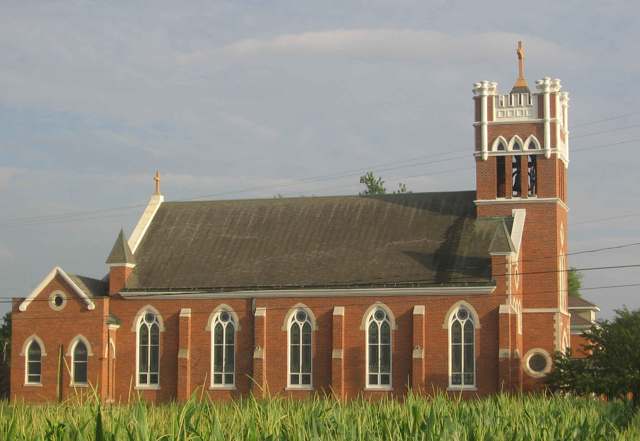
Photo: MrHarman, CC BY-SA 3.0 · Wikimedia Commons
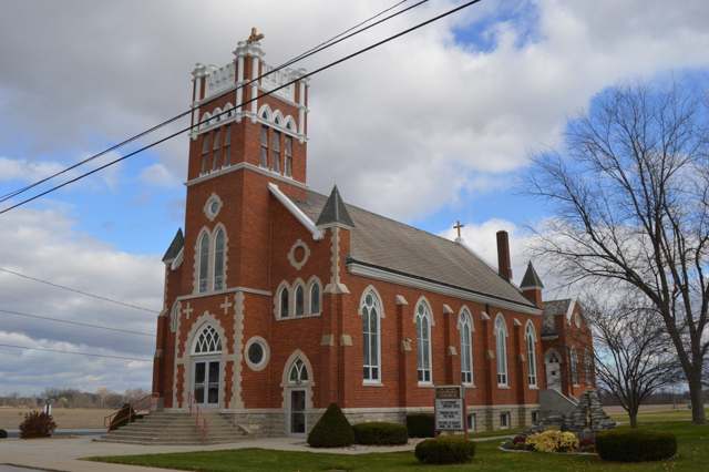
Photo: Nyttend, public domain · Wikimedia Commons
Local history sources: en.wikipedia.org · archive.org · archive.org · archive.org · en.wikipedia.org · commons.wikimedia.org · commons.wikimedia.org · commons.wikimedia.org
Water
No water-system data is linked to Blakeslee's ZIP codes yet.
Its ZIP codes
Each ZIP code that touches Blakeslee, with the share of its residents who live here and the same headline figures as the ZIP page.
| ZIP | Share | Water | Radon | Home value | Schools | Flood |
|---|---|---|---|---|---|---|
| 43505 Blakeslee | 100% | Mostly private wells | Too few radon tests | Median year built 1920 | Edon-Northwest Local · 3.5 stars overall | No digital FEMA flood map for this county |
Local government
Who holds office in Blakeslee, how its elections and ballot issues came out, and the state auditor's record.
Who holds office
| Office | Name | Party | Term ends | Contact |
|---|---|---|---|---|
| Fiscal Officer | Courtny Osborne | |||
| Member of Council | Robert J. Mohre | 2029-12-31 | 513 Washington St | |
| Member of Council | Nicholas Reed | 2029-12-31 | 425 Madison St. | |
| Member of Council | Linda L. Muehlfeld | 2029-12-31 | 130 Washington St. | |
| Member of Council | Virgil Green | 2027-12-31 | 203 Dearborn St. | |
| Member of Council | Shelly Cox | 2027-12-31 | 500 Washington St. | |
| Mayor | Eric Jenkins | 2027-12-31 | 124 Washington St, Pob 231 | |
| Clerk-Treasurer | John Lehner |
Roster as of 2026-07-06: county board of elections.
Auditor of State record
- No fiscal caution, watch or emergency on the Auditor of State's lists.
- Basic Audit, 2024 to 2025, released 2026-06-18
The county
Williams County: 10 ZIP codes, 22 cities, villages and townships, 38,264 people.
Nearby places
No nearby place shares a ZIP code with Blakeslee in the atlas yet.
Rain and snow
How much has actually fallen on Blakeslee, day by day, from 1893 to now. Daily totals, not averages.
- rain, last 30 days
- 2.48 in
- 2026-09-30 to 2026-10-29
- rain so far in 2026
- 33.1 in
- about normal for the date
- snow so far in 2026
- 17.1 in
- a normal year brings 30.6 in
- a normal year
- 37.2 in
- average of 30 years, 1991-2020
| Month | Rain (in) | Snow (in) | Days counted |
|---|---|---|---|
| October 2026 | 2.48 | — | 29 |
| September 2026 | 4.25 | — | 30 |
| August 2026 | 4.67 | — | 31 |
| July 2026 | 2.08 | — | 31 |
| June 2026 | 2.73 | — | 30 |
| May 2026 | 2.17 | — | 31 |
| April 2026 | 7.27 | — | 30 |
| March 2026 | 5.58 | 0.8 | 31 |
| February 2026 | 0.77 | 4.4 | 28 |
| January 2026 | 1.16 | 11.8 | 31 |
| December 2025 | 1.99 | 7.7 | 31 |
| November 2025 | 1.95 | 10.6 | 30 |
| Wettest year | 2011 — 51.3 in |
|---|---|
| Driest year | 1963 — 21.8 in |
| Snowiest year | 2014 — 67.0 in |
| Wettest day on record | 21 June 1937 — 3.77 in |
| Heaviest snowfall in a day | 27 February 1900 — 14.43 in |
| Deepest snow on the ground | 9 February 1982 — 23.12 in |
Estimated, not measured. No rain gauge has ever stood inside Blakeslee, so every figure here is worked out from the gauges around it - the nearest ones weighted most. Treat them as close estimates rather than readings.
48,794 days of records, 1893-01-01 to 2026-10-29. Source: NOAA NCEI GHCN-Daily, 3,240 gauges in and around Ohio. A day is "gauged" when a gauge standing inside the boundary reported it, and the value is the mean of those gauges. Otherwise it is interpolated by inverse distance from every gauge reporting within 50 miles. Nothing is carried forward, back-filled or smoothed. Against NOAA nClimDiv county monthly precipitation over 136,848 complete county-months (checked 2026-10-31): correlation 0.9515, median absolute difference 0.217 in a month. Built 2026-10-31 from the Cracked Buckeye precipitation archive. Snow is the softer number — snowfall is measured by hand with a ruler, no agency publishes a gridded county snowfall series, and blowing snow defeats every observer.
Environmental permits and filings
What Ohio EPA has on file for Blakeslee: permits, inspections, violations, cleanups and the state loans behind sewer and water work. Every line links to the agency's own document.
- facilities and sites on file
- 2
- those placed on the map inside Blakeslee
| Program | Facilities and sites |
|---|---|
| Hazardous waste | 1 |
| Public drinking water | 1 |
| Date | Facility or site | What |
|---|---|---|
| SAMS PLACE TAVERN PWS | Public drinking water compliance letter | |
| SAMS PLACE TAVERN PWS | Public drinking water compliance letter | |
| SAMS PLACE TAVERN PWS | Public drinking water permit | |
| SAMS PLACE TAVERN PWS | Public drinking water violation resolved | |
| SAMS PLACE TAVERN PWS | Public drinking water notice of violation | |
| SAMS PLACE TAVERN PWS | Public drinking water inspection | |
| SAMS PLACE TAVERN PWS | Public drinking water inspection | |
| SAMS PLACE TAVERN PWS | Public drinking water inspection | |
| SAMS PLACE TAVERN PWS | Public drinking water inspection | |
| SAMS PLACE TAVERN | Public drinking water compliance letter | |
| SAMS PLACE TAVERN | Public drinking water compliance letter | |
| SAMS PLACE TAVERN | Public drinking water inspection | |
| SAMS PLACE TAVERN PWS | Public drinking water inspection |
Source: Ohio EPA eDocument portal (edocpub.epa.ohio.gov), indexed 2026-10-14. Facilities are placed on the map from Ohio EPA's own map layers, EPA's Facility Registry, coordinates written in the filings, or a geocoded street address. A permit filed under a private person's name (most are household septic systems) is counted but never named, placed or linked; licenses for individual workers and open-burning notices are left out entirely.
Quick answers
What county is Blakeslee, Ohio in?
Blakeslee is a village in Williams County, Ohio, with 104 residents.
When was Blakeslee, Ohio founded?
Blakeslee was settled 1853 (John Boman on the village site); laid out November 1880; incorporated 1894. Founders on record: John Boman. Source
How did Blakeslee, Ohio get its name?
Named by John Boman for S. Source
What ZIP code is Blakeslee, Ohio?
Most of Blakeslee is in ZIP code 43505.
Where does Blakeslee, Ohio get its water?
The main water source for Blakeslee: Mostly private wells.
Cite this page
Cite this page as:
Cracked Buckeye, "Blakeslee, Williams County", https://crackedbuckeye.com/place/blakeslee/, built 2026-10-31, accessed [date].
How to cite · Report a correction · Built 2026-10-31
