Plays from YouTube when you press play.
Deep dives · 2026-09-30
The lost valley under Salt Fork Lake: covered bridges, Clio and a stone house #shorts
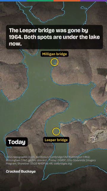
Before Salt Fork Dam closed in 1967, the valley north of Cambridge, Ohio held farms, the crossroads of Clio with its store, post office and 1849 Armstrong Mill covered bridge (moved to Cambridge City Park in 1966, still standing), and the Gunn covered bridge, left in place as the water rose; its frame stood in the lake until the early 1980s. Plus the Kennedy Stone House, 1837, now the park museum. 1962 vs today maps and aerials, an April 1960 survey photo, and the bare valley behind the dam in December 1967. Did your family know the valley?
Maps and aerials: USGS topos 1961-62/1993-94 and aerial April 1960 (public domain); OGRIP Ohio Statewide Imagery Program. Photos: Columbus Metropolitan Library; bettyshinn.com (Marilyn McCormick Murphy, Nancy Ankrum); lostbridges.org (Todd Clark Collection; Henry Davidson, Richard E. Roy Collection, NSPCB Archives); TrekOhio; The Daily Jeffersonian via Guernsey County Historical Society; Bwsmith84 via Wikimedia Commons, CC BY 3.0.
Narration: AI voice.
Watch on YouTube. Follow us on YouTube, TikTok, Facebook, Instagram.
More videos
 What's Coming to Frazeysburg? 4 Million Square Feet for a "Confidential End User"
 What Ohio lost, and what came back: 200 years of wildlife
 Amlin, Ohio: the railroad village Dublin grew around
 The valley under Alum Creek Lake: Africa, Ohio and the Underground Railroad
 The Kahiki: Columbus's lost tiki palace (1961-2000)
 Big Muskie: The Biggest Machine That Ever Walked Ohio (and What Killed It)
Cite this page
Cite this page as:
Cracked Buckeye, "The lost valley under Salt Fork Lake: covered bridges, Clio and a stone house #shorts", https://crackedbuckeye.com/videos/salt-fork-lake/, built 2026-10-04, accessed [date].
How to cite · Report a correction · Built 2026-10-04