Local events in Vanlue
Nothing is posted for Vanlue itself yet; here is what is on within 10 miles. All local events in Vanlue
Know a calendar we should watch? Send the link
Checked October 20; the events page is refreshed daily.
How Vanlue began
Vanlue was platted in May 1847 by William Vanlue on land in Amanda Township near where Thomas Thompson, the township's first settler, had built a cabin and planted the county's first crop a quarter-century earlier. The village grew into a substantial grain market after the railroad reached it, and a post office opened in 1850. Its population has swung between roughly 340 and 540 over the last century and a half, peaking in 1970. About two miles east, just across the county line, lies Sheriden Cave, one of Ohio's most important Paleo-Indian sites, where tools and animal remains dated to 11,000-12,000 years ago were found in a sinkhole. Vanlue remains a small farm-market village in eastern Hancock County today.
Settled 1822-1823 (Thomas Thompson settles nearby, the area's first entry and crop), platted May 1847, by William Vanlue, with an initial forty-four lots, by William Vanlue.
Where the name comes from
The village is named for its founder, William Vanlue, who platted it in 1847.
Before the town
No named Native village, mound, or treaty reserve is recorded within the site of Vanlue itself in the sources checked. About two miles east of the village, across the Hancock-Wyandot county line in Ridge Township, Wyandot County, is Sheriden Cave, a karst sinkhole where excavations beginning in the 1990s recovered radiocarbon-dated bone tools, a fluted Clovis-culture spear point, and remains of extinct Ice Age animals including giant short-faced bear and stag moose, showing human use of the area roughly 11,000 to 12,000 years ago -- among the earliest and best-documented evidence of human presence anywhere in Ohio. The cave is outside Hancock County and is not itself a Vanlue site, but its closeness marks the surrounding Blanchard's Fork valley as long-inhabited ground. No historic-era (1700s-1800s) Native village or reserve specific to Vanlue was found in the sources reviewed.
- Sheriden Cave (near, not within, Vanlue) (other) — Ridge Township, Wyandot County, Ohio, about 2 miles east of Vanlue, Paleo-Indian, roughly 11,000-12,000 years before present (radiocarbon dated) (en.wikipedia.org)
Timeline
- — William Vanlue plats the village with an initial forty-four lots.
- — A post office opens at Vanlue.
- — Thomas Thompson, Amanda Township's first settler and first Justice of the Peace, dies at Vanlue.
- — Vanlue's population is recorded as 364 in that year's federal census, its earliest census figure.
- — The county history notes Vanlue 'was a very considerable grain market for a number of years after the completion of the railroad.'
- — Vanlue's population peaks at 539, a 39.6% jump from 1960.
- — A bulldozer exposes Sheriden Cave, near Vanlue across the county line, and Kent State University archaeologist Kenneth Tankersley begins excavations that uncover Paleo-Indian tools and Ice Age animal remains.
Stories
A grain town built on a founder's own name
William Vanlue laid out his namesake village in May 1847 on Amanda Township ground that Thomas Thompson had first claimed twenty-five years earlier, in 1822, when he built a cabin near the Big Springs and planted what the county history counts as the township's first crop. Vanlue the village took a generation to become more than a crossroads, but once a railroad reached it the difference was dramatic: the 1881 county history records it as 'a very considerable grain market for a number of years after the completion of the railroad,' as wheat and corn from Amanda Township's farms funneled through its elevators. The village's population has risen and fallen with the fortunes of small-town Ohio ever since, from 364 residents at its first census in 1880 to a high of 539 in 1970 before settling near 340 in recent counts.
Ice-Age hunters two miles from the grain elevator
A short drive east of Vanlue, a bulldozer clearing ground in 1995 broke into a sinkhole that turned out to hold one of the most important Paleo-Indian sites in the eastern United States. Kenneth Tankersley of Kent State University led excavations there for about three years starting in 1997, recovering bone spear points, a flint hide-scraper, a fluted Clovis-culture point, and even preserved plant matter and human waste, alongside the bones of extinct Ice Age animals -- a giant short-faced bear, a stag moose, a flat-headed peccary, a giant beaver. Radiocarbon dating put the material at 11,000 to 12,000 years old, meaning people were camping and hunting in this stretch of the Blanchard's Fork valley roughly ten thousand years before William Vanlue platted his village, in weather and with wildlife almost unrecognizable from the farm country that surrounds Vanlue today.
Photographs
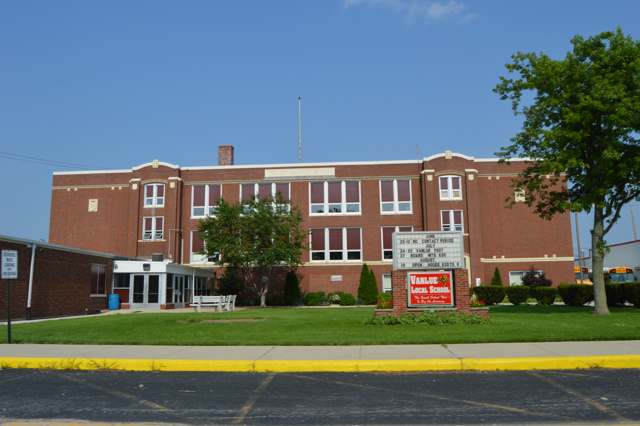
Photo: Nyttend, Public domain · Wikimedia Commons
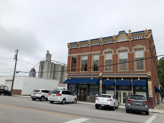
Photo: Mbrickn, CC BY 4.0 · Wikimedia Commons
Local history sources: ohiogenealogyexpress.com · en.wikipedia.org · en.wikipedia.org · en.wikipedia.org · commons.wikimedia.org · commons.wikimedia.org
Water
Mostly private wells The water here
- Vanlue Village100% of residentsGroundwater wells (3 wells)
Hospitals, fire stations and more
Inside Vanlue's boundary: 1 fire or EMS station and 2 public schools. Press a pin or a name for its whole record and its source.
Fire and EMS stations (1)
-
Vanlue Fire DepartmentVanlue
- Address
- 396 South Blanchard Street, Vanlue, OH 45890
- Coordinates
- 40.97257, -83.48616
USGS National Map structures (source) ↗ Street map and directions ↗
Source: USGS National Map structures (most Ohio records last updated 2019 to 2022), checked against the Columbus and Cleveland station lists. The department that answers a call is set by jurisdiction and mutual aid, not by distance.
Public schools (2)
-
Vanlue Elementary School2.5 of 5 stars · Vanlue
- Address
- 301 S. East St, Vanlue, OH 45890
- School district
- Vanlue Local School District
- Kind (NCES)
- Regular School
- Students, 2023-24
- 53
- Teachers (full-time equivalent)
- 9.5
- Report card, 2025-26
- 2.5 of 5 stars
- Performance index
- 66.5%
- Ohio building IRN
- 038281
- NCES school ID
- 390474702901
NCES school record ↗ Ohio School Report Card ↗ Street map and directions ↗
-
Vanlue High School4 of 5 stars · Vanlue
- Address
- 301 S. East St, Vanlue, OH 45890
- School district
- Vanlue Local School District
- Kind (NCES)
- Regular School
- Students, 2023-24
- 98
- Teachers (full-time equivalent)
- 5.5
- Report card, 2025-26
- 4 of 5 stars
- Performance index
- 70.7%
- Four-year graduation rate
- 100%
- Ohio building IRN
- 038299
- NCES school ID
- 390474702902
NCES school record ↗ Ohio School Report Card ↗ Street map and directions ↗
Source: NCES EDGE public school locations 2024-25 and Common Core of Data 2023-24 (type, students, teachers); Ohio School Report Cards 2025-26 (Department of Education and Workforce), matched by name within the district.
Its ZIP codes
Each ZIP code that touches Vanlue, with the share of its residents who live here and the same headline figures as the ZIP page.
| ZIP | Share | Water | Radon | Home value | Schools | Flood |
|---|---|---|---|---|---|---|
| 45890 Amanda Township and Vanlue | 44% | Mostly private wells | 3.2 pCi/L average radon | Parcel list only | Vanlue Local · 3.5 stars overall | 0.0% of residents in the 1% floodplain |
Local government
Who holds office in Vanlue, how its elections and ballot issues came out, and the state auditor's record.
Who holds office
| Office | Name | Party | Term ends | Contact |
|---|---|---|---|---|
| Mayor | Robert Wells | 567-208-3722 · website |
Roster as of 2026 edition (Directory of Officials): county board of elections.
Elections for office
| Date | Office | Candidates and votes |
|---|---|---|
| 2025-11-04 | Mayor | Robert Wells 37, 100.0% |
| 2023-11-07 | Council | Ann Louise Burrell 102, 100.0% |
| 2021-11-02 | Council | Melissa A. Caudill 58, 0.47%; Robert Greene 62, 0.51%; Rebecca Nye 64, 0.52%; Melissa Sunderhaus 40, 0.33%; Amy Wiseley 78, 0.64%; Nancy N. George 4,107, 33.59%; Mark Gleason 3,894, 31.84%; John D. Oman 4,227, 34.57% |
| 2019-11-05 | Mayor | Louis W. Abraham 47, 37.6%; Robert Brooks 78, 62.4% |
| 2019-11-05 | Council | Ann Louise Burrell 99, 52.38%; Jeri R. Wenger 90, 47.62% |
Winners in bold. Results from the county board of elections' official canvass unless marked.
Auditor of State record
- No fiscal caution, watch or emergency on the Auditor of State's lists.
- Financial Audit, 2023 to 2024, released 2025-11-25
The county
Hancock County: 12 ZIP codes, 26 cities, villages and townships, 68,477 people.
Nearby places
Rain and snow
How much has actually fallen on Vanlue, day by day, from 1893 to now. Daily totals, not averages.
- rain, last 30 days
- 0.96 in
- 2026-09-29 to 2026-10-28
- rain so far in 2026
- 31.9 in
- about normal for the date
- snow so far in 2026
- 11.6 in
- a normal year brings 26.7 in
- a normal year
- 37.4 in
- average of 30 years, 1991-2020
| Month | Rain (in) | Snow (in) | Days counted |
|---|---|---|---|
| October 2026 | 0.96 | — | 28 |
| September 2026 | 3.85 | — | 30 |
| August 2026 | 4.18 | — | 31 |
| July 2026 | 3.19 | — | 31 |
| June 2026 | 3.52 | — | 30 |
| May 2026 | 4.36 | — | 31 |
| April 2026 | 6.11 | — | 30 |
| March 2026 | 4.07 | 0.2 | 31 |
| February 2026 | 0.40 | 2.3 | 28 |
| January 2026 | 1.23 | 9.0 | 31 |
| December 2025 | 1.79 | 7.9 | 31 |
| November 2025 | 1.27 | 2.3 | 30 |
| Wettest year | 2011 — 54.6 in |
|---|---|
| Driest year | 1934 — 22.7 in |
| Snowiest year | 1910 — 62.7 in |
| Wettest day on record | 21 August 2007 — 5.03 in |
| Heaviest snowfall in a day | 23 December 2004 — 10.01 in |
| Deepest snow on the ground | 6 February 1978 — 19.75 in |
Estimated, not measured. No rain gauge has ever stood inside Vanlue, so every figure here is worked out from the gauges around it - the nearest ones weighted most. Treat them as close estimates rather than readings.
48,819 days of records, 1893-01-01 to 2026-10-28. Source: NOAA NCEI GHCN-Daily, 3,240 gauges in and around Ohio. A day is "gauged" when a gauge standing inside the boundary reported it, and the value is the mean of those gauges. Otherwise it is interpolated by inverse distance from every gauge reporting within 50 miles. Nothing is carried forward, back-filled or smoothed. Against NOAA nClimDiv county monthly precipitation over 136,848 complete county-months (checked 2026-10-31): correlation 0.9515, median absolute difference 0.217 in a month. Built 2026-10-31 from the Cracked Buckeye precipitation archive. Snow is the softer number — snowfall is measured by hand with a ruler, no agency publishes a gridded county snowfall series, and blowing snow defeats every observer.
Environmental permits and filings
What Ohio EPA has on file for Vanlue: permits, inspections, violations, cleanups and the state loans behind sewer and water work. Every line links to the agency's own document.
- facilities and sites on file
- 2
- those placed on the map inside Vanlue
| Program | Facilities and sites |
|---|---|
| Public drinking water | 2 |
| Date | Facility or site | What |
|---|---|---|
| VANLUE VILLAGE PWS | Public drinking water compliance letter | |
| VANLUE VILLAGE PWS | Public drinking water inspection | |
| VANLUE VILLAGE PWS | Public drinking water violation resolved | |
| VANLUE VILLAGE PWS | Public drinking water report | |
| VANLUE VILLAGE PWS | Public drinking water notice of violation | |
| VANLUE VILLAGE PWS | Public drinking water inspection | |
| VANLUE VILLAGE PWS | Public drinking water compliance letter | |
| VANLUE VILLAGE PWS | Public drinking water notice of violation | |
| VANLUE VILLAGE PWS | Public drinking water report | |
| VANLUE VILLAGE PWS | Public drinking water violation resolved | |
| VANLUE VILLAGE PWS | Public drinking water notice of violation | |
| VANLUE VILLAGE PWS | Public drinking water plan | |
| VANLUE VILLAGE PWS | Public drinking water notice of violation | |
| VANLUE VILLAGE PWS | Public drinking water notice of violation | |
| VANLUE VILLAGE PWS | Public drinking water notice of violation | |
| VANLUE VILLAGE PWS | Public drinking water compliance letter | |
| VANLUE VILLAGE PWS | Public drinking water notice of violation | |
| VANLUE VILLAGE PWS | Public drinking water report | |
| VANLUE VILLAGE PWS | Public drinking water compliance letter | |
| VANLUE VILLAGE PWS | Public drinking water inspection | |
| VANLUE VILLAGE PWS | Public drinking water inspection | |
| VANLUE VILLAGE PWS | Public drinking water violation resolved | |
| VANLUE VILLAGE PWS | Public drinking water notice of violation | |
| VANLUE VILLAGE PWS | Public drinking water report | |
| VANLUE VILLAGE PWS | Public drinking water violation resolved |
Source: Ohio EPA eDocument portal (edocpub.epa.ohio.gov), indexed 2026-10-14. Facilities are placed on the map from Ohio EPA's own map layers, EPA's Facility Registry, coordinates written in the filings, or a geocoded street address. A permit filed under a private person's name (most are household septic systems) is counted but never named, placed or linked; licenses for individual workers and open-burning notices are left out entirely.
Quick answers
What county is Vanlue, Ohio in?
Vanlue is a village in Hancock County, Ohio, with 289 residents.
When was Vanlue, Ohio founded?
Vanlue was settled 1822-1823 (Thomas Thompson settles nearby, the area's first entry and crop); laid out May 1847, by William Vanlue, with an initial forty-four lots. Founders on record: William Vanlue. Source
How did Vanlue, Ohio get its name?
The village is named for its founder, William Vanlue, who platted it in 1847. Source
What ZIP code is Vanlue, Ohio?
Most of Vanlue is in ZIP code 45890.
Where does Vanlue, Ohio get its water?
The main water source for Vanlue (Vanlue Village): Mostly private wells.
Cite this page
Cite this page as:
Cracked Buckeye, "Vanlue, Hancock County", https://crackedbuckeye.com/place/vanlue/, built 2026-10-31, accessed [date].
How to cite · Report a correction · Built 2026-10-31
