Local events in Tiltonsville
Nothing is posted for Tiltonsville itself yet; here is what is on within 20 miles. All local events in Tiltonsville
Know a calendar we should watch? Send the link
Checked October 20; the events page is refreshed daily.
How Tiltonsville began
Tiltonsville was founded in 1806 by John Tilton, who had bought the full 900-acre Section No. 22 at a Pittsburgh federal land auction on November 25, 1796 for $3,623.76 -- a deed signed by President John Adams and dated November 20, 1797. Tilton and Charles Kimball had already been in the area since about 1784-85, part of Warren Township's earliest settlement wave. A post office opened in 1852 as 'Tiltonville,' and residents changed the spelling to 'Tiltonsville' in 1875. The village holds Hodgen's Cemetery Mound, an intact, never-formally-excavated Adena culture burial mound listed on the National Register of Historic Places since 1975; Tiltonsville's population peaked at 2,454 in 1960 and had fallen to 1,259 by the 2020 census.
Settled c. 1784-85 (John Tilton and Charles Kimball), platted 1806, incorporated date not found in sources reviewed, by John Tilton.
Where the name comes from
Named for John Tilton, who purchased the 900-acre section on which the village stands at a Pittsburgh federal land auction in 1796 and platted the village in 1806.
Before the town
Tiltonsville holds one of the few site-specific, physically confirmed Native American sites we found documented in Jefferson County: Hodgen's Cemetery Mound, a roughly one-acre, cone-shaped Adena culture burial mound along the Ohio River shoreline, built sometime between about 500 BC and AD 500. The mound has never been formally excavated, but erosion has exposed human remains including a skull showing artificial cranial deformation, a documented Adena and Hopewell-era practice. It sits inside a 19th-century cemetery later established by Tiltonsville's white residents, and has been listed on the National Register of Historic Places since September 25, 1975. Separately, the township's own settlement-era history records that Jack Tilton, a boy of twelve to fourteen believed to be a relative of the village's founder John Tilton, was killed by a Native war party near Short Creek sometime between 1789 and 1794, before the village existed.
Nations recorded here: Adena culture.
- Hodgen's Cemetery Mound (mound) — Hodgen's Cemetery, off Walden Avenue, Tiltonsville, Adena culture, c. 500 BC - AD 500 (en.wikipedia.org)
Timeline
- — John Tilton buys the full 900-acre Section No. 22 at a Pittsburgh federal land auction on November 25 for $3,623.76.
- — Tilton's deed to the land, signed by President John Adams, is dated November 20.
- — John Tilton establishes the village that takes his name.
- — A post office opens under the name 'Tiltonville.'
- — Residents change the spelling of the post office and village name to 'Tiltonsville.'
- — Village population peaks at 2,454.
- — Hodgen's Cemetery Mound is listed on the National Register of Historic Places on September 25.
Stories
A mound that erosion excavated, not archaeologists
Hodgen's Cemetery Mound has never been formally excavated, yet it has given up some of its secrets anyway. Nineteenth-century Tiltonsville residents built their own cemetery around and partly on top of the roughly one-acre, cone-shaped Adena mound along the Ohio River shoreline, and over the following century natural erosion of the hillside has periodically exposed human remains -- including, at one point, a skull showing artificial cranial deformation, a burial practice documented among Adena and Hopewell-era peoples elsewhere in Ohio. Modern grave-digging on the mound's southwestern side has disturbed it further, but its general conical shape survives, and it has stood on the National Register of Historic Places since 1975 -- a rare case, in this stretch of the county, of a specific, physically locatable prehistoric Native site rather than only a documented history of the historic-era nations who arrived later.
Photographs
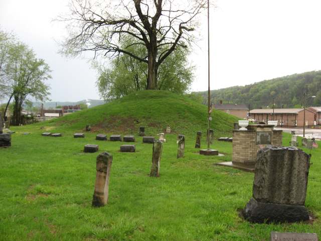
Photo: Nyttend, Wikimedia Commons, public domain · Wikimedia Commons
Local history sources: en.wikipedia.org · en.wikipedia.org · ohiogenealogyexpress.com
Water
Groundwater wells (2 wells) The water here
- Tiltonsville100% of residentsGroundwater wells (2 wells)
Hospitals, fire stations and more
Inside Tiltonsville's boundary: 1 fire or EMS station, 1 public school, 1 library and 1 mound or earthwork. Press a pin or a name for its whole record and its source.
Fire and EMS stations (1)
-
Tiltonsville Volunteer Fire DepartmentTiltonsville
- Address
- 123B Grandview Avenue, Tiltonsville, OH 43963
- Coordinates
- 40.16858, -80.69730
USGS National Map structures (source) ↗ Street map and directions ↗
Source: USGS National Map structures (most Ohio records last updated 2019 to 2022), checked against the Columbus and Cleveland station lists. The department that answers a call is set by jurisdiction and mutual aid, not by distance.
Public schools (1)
-
Buckeye South Elementary School2.5 of 5 stars · Tiltonsville
- Address
- 100 Walden Ave, Tiltonsville, OH 43963
- School district
- Buckeye Local School District
- Kind (NCES)
- Regular School
- Students, 2023-24
- 313
- Teachers (full-time equivalent)
- 23.56
- Report card, 2025-26
- 2.5 of 5 stars
- Performance index
- 70%
- Ohio building IRN
- 042515
- NCES school ID
- 390477802981
NCES school record ↗ Ohio School Report Card ↗ Street map and directions ↗
Source: NCES EDGE public school locations 2024-25 and Common Core of Data 2023-24 (type, students, teachers); Ohio School Report Cards 2025-26 (Department of Education and Workforce), matched by name within the district.
Public libraries (1)
-
Tiltonsville BranchBranch · Tiltonsville
- Address
- 702 Walden Ave, Tiltonsville, OH 43963
- What it is
- Branch
- Library system
- Steubenville & Jefferson County, Pl Of
- Open
- 2,225 hours a year, 52 weeks
- Building
- 3,000 sq ft
- System's visits, FY2024
- 130,624
- System's loans, FY2024
- 358,384
- People the system serves
- 65,249
- Phone
- (740) 314-4280
IMLS Public Libraries Survey (source) ↗ Street map and directions ↗
Source: IMLS Public Libraries Survey FY2024 (outlets and their systems). Any Ohio resident can get a free card at any Ohio public library.
Mounds and earthworks (1)
-
Hodgen's Cemetery MoundMound · Adena culture
- What it is
- Mound
- Age
- Adena culture, c. 500 BC - AD 500
- Where
- Hodgen's Cemetery, off Walden Avenue, Tiltonsville
- County
- Jefferson County
- Named in the history of
- Tiltonsville (village), Jefferson County
- Map point
- from the site's Wikipedia article
Wikipedia article (point and source) ↗ Street map and directions ↗
Many mounds stand on private land; visit only those open to the public.
Source: the History records' native sites, each placed by its own Wikipedia article; sites no article places are named on the History card but not pinned.
Its ZIP codes
Each ZIP code that touches Tiltonsville, with the share of its residents who live here and the same headline figures as the ZIP page.
| ZIP | Share | Water | Radon | Home value | Schools | Flood |
|---|---|---|---|---|---|---|
| 43963 Tiltonsville | 100% | Groundwater wells (2 wells) | 5.8 pCi/L average radon | Median year built 1938 | Buckeye Local · 3 stars overall | 8.2% of residents in the 1% floodplain |
Local government
Who holds office in Tiltonsville, how its elections and ballot issues came out, and the state auditor's record.
Money issues on the ballot since 2020: 2 of 2 passed.
Ballot issues
| Date | Issue | For | Against | Result |
|---|---|---|---|---|
| 2021-11-02 | Issue 13: Tiltonsville Marihuana Ordinance | 168 | 156 | Passed (51.85% for) |
| 2020-11-03 | Issue 13: Tiltonsville-Renewal-Current Expenses-3 mills (3.0 mills, renewal) | 446 | 231 | Passed (65.88% for) |
| 2020-11-03 | Issue 14: Tiltonsville-Renewal-Police Protection-4.9 mills (4.9 mills, renewal) | 425 | 251 | Passed (62.87% for) |
Elections for office
| Date | Office | Candidates and votes |
|---|---|---|
| 2023-11-07 | Member of Council | Kristine S. Prati 177, 24.45%; Brandon Staats 142, 19.61%; Stacy Totterdale 215, 29.7%; Ricky Verardi 190, 26.24% |
| 2023-11-07 | Mayor | Kelly J. Klubert 171, 39.04%; Jason Staskey 267, 60.96% |
| 2021-11-02 | Member of Council | Dennis Ray Gorlock Jr. 132, 21.67%; Susan Gorlock 121, 19.87%; Kelly J. Klubert 172, 28.24%; Kimberly Malechowski 184, 30.21% |
Winners in bold. Results from the county board of elections' official canvass unless marked.
Auditor of State record
- No fiscal caution, watch or emergency on the Auditor of State's lists.
- Financial Audit, 2023 to 2024, released 2025-10-14
The county
Jefferson County: 21 ZIP codes, 33 cities, villages and townships, 67,859 people.
Nearby places
No nearby place shares a ZIP code with Tiltonsville in the atlas yet.
Rain and snow
How much has actually fallen on Tiltonsville, day by day, from 1878 to now. Daily totals, not averages.
- rain, last 30 days
- 2.14 in
- 2026-09-30 to 2026-10-29
- rain so far in 2026
- 41.9 in
- 7.4 in above normal for the date
- snow so far in 2026
- 19.6 in
- a normal year brings 17.3 in
- a normal year
- 40.6 in
- average of 30 years, 1991-2020
| Month | Rain (in) | Snow (in) | Days counted |
|---|---|---|---|
| October 2026 | 2.14 | — | 29 |
| September 2026 | 5.10 | — | 30 |
| August 2026 | 10.15 | — | 31 |
| July 2026 | 3.09 | — | 31 |
| June 2026 | 3.26 | — | 30 |
| May 2026 | 4.78 | — | 31 |
| April 2026 | 4.14 | 0.0 | 30 |
| March 2026 | 6.80 | 2.4 | 31 |
| February 2026 | 0.72 | 2.5 | 28 |
| January 2026 | 1.65 | 14.7 | 31 |
| December 2025 | 1.89 | 11.4 | 31 |
| November 2025 | 2.36 | — | 30 |
| Wettest year | 2018 — 62.6 in |
|---|---|
| Driest year | 1930 — 24.6 in |
| Snowiest year | 1910 — 63.3 in |
| Wettest day on record | 18 September 2004 — 5.24 in |
| Heaviest snowfall in a day | 25 November 1950 — 16.70 in |
| Deepest snow on the ground | 29 November 1950 — 24.52 in |
Estimated, not measured. No rain gauge has ever stood inside Tiltonsville, so every figure here is worked out from the gauges around it - the nearest ones weighted most. Treat them as close estimates rather than readings.
51,214 days of records, 1878-02-01 to 2026-10-29. Source: NOAA NCEI GHCN-Daily, 3,240 gauges in and around Ohio. A day is "gauged" when a gauge standing inside the boundary reported it, and the value is the mean of those gauges. Otherwise it is interpolated by inverse distance from every gauge reporting within 50 miles. Nothing is carried forward, back-filled or smoothed. Against NOAA nClimDiv county monthly precipitation over 136,848 complete county-months (checked 2026-10-31): correlation 0.9515, median absolute difference 0.217 in a month. Built 2026-10-31 from the Cracked Buckeye precipitation archive. Snow is the softer number — snowfall is measured by hand with a ruler, no agency publishes a gridded county snowfall series, and blowing snow defeats every observer.
Environmental permits and filings
What Ohio EPA has on file for Tiltonsville: permits, inspections, violations, cleanups and the state loans behind sewer and water work. Every line links to the agency's own document.
- facilities and sites on file
- 10
- those placed on the map inside Tiltonsville
| Program | Facilities and sites |
|---|---|
| Air pollution | 5 |
| Contaminated-site cleanup | 1 |
| Hazardous waste | 1 |
| Site assessment | 1 |
| State sewer loans | 1 |
| State water loans | 1 |
| Date | Facility or site | What |
|---|---|---|
| TILTONSVILLE WWTP | State sewer loans | |
| TILTONSVILLE PWS | State water loans | |
| TILTONSVILLE PWS | State water loans | |
| WARRENTON RIVER TERMINAL LLC | Air pollution report | |
| WALDEN INDUSTRIES | Air pollution report | |
| TILTONSVILLE PWS | State water loans | |
| TILTONSVILLE PWS | State water loans | |
| TILTONSVILLE WWTP | State sewer loans | |
| TILTONSVILLE PWS | State water loans | |
| SMITH CONCRETE PLANT #05456 | Air pollution permit | |
| WARRENTON RIVER TERMINAL LLC | Air pollution permit | |
| WALDEN INDUSTRIES | Air pollution permit | |
| WALDEN INDUSTRIES INC | Air pollution permit | |
| SMITH CONCRETE PLANT #05456 | Air pollution permit | |
| TECHNISAND, INC. TILTONSVILLE TERMINAL | Air pollution violation resolved | |
| TECHNISAND, INC. TILTONSVILLE TERMINAL | Air pollution notice of violation | |
| MARTIN MARIETTA MATERIALS INC | Air pollution permit |
Source: Ohio EPA eDocument portal (edocpub.epa.ohio.gov), indexed 2026-10-14. Facilities are placed on the map from Ohio EPA's own map layers, EPA's Facility Registry, coordinates written in the filings, or a geocoded street address. A permit filed under a private person's name (most are household septic systems) is counted but never named, placed or linked; licenses for individual workers and open-burning notices are left out entirely.
Quick answers
What county is Tiltonsville, Ohio in?
Tiltonsville is a village in Jefferson County, Ohio, with 1,259 residents.
When was Tiltonsville, Ohio founded?
Tiltonsville was settled c. 1784-85 (John Tilton and Charles Kimball); laid out 1806; incorporated date not found in sources reviewed. Founders on record: John Tilton. Source
How did Tiltonsville, Ohio get its name?
Named for John Tilton, who purchased the 900-acre section on which the village stands at a Pittsburgh federal land auction in 1796 and platted the village in 1806. Source
What ZIP code is Tiltonsville, Ohio?
Most of Tiltonsville is in ZIP code 43963.
Where does Tiltonsville, Ohio get its water?
The main water source for Tiltonsville (Tiltonsville): Groundwater wells (2 wells).
Cite this page
Cite this page as:
Cracked Buckeye, "Tiltonsville, Jefferson County", https://crackedbuckeye.com/place/tiltonsville/, built 2026-10-31, accessed [date].
How to cite · Report a correction · Built 2026-10-31
