Local events in Shawnee
Nothing is posted for Shawnee itself yet; here is what is on within 20 miles. All local events in Shawnee
Know a calendar we should watch? Send the link
Checked October 20; the events page is refreshed daily.
How Shawnee began
Shawnee was platted in 1872 by investor T.J. Davis on the former Israel Gordon farm after the railroad reached the site, and incorporated as a village in 1874 at the start of a coal, clay, and oil boom. It took its name from the Shawnee people, who had a village along Shawnee Run before removal. Welsh, Irish, and Eastern European immigrant miners poured in through the 1890s and 1900s, pushing the population past 3,000; the 1890 census counted 3,266. Coal's long decline through the 20th century cut that by about 85 percent, to 505 residents by 2020, leaving a business district still built for a much larger town.
Platted 1872, incorporated 1874, by T.J. Davis, on the former Israel Gordon farm.
Where the name comes from
Named for the Shawnee people, whose village stood on Shawnee Run, the creek the town sits along in Salt Lick Township.
Before the town
The 1883 History of Perry County records that early European settlers found no permanent Native towns in the county itself, only trails and hunting ground shared by the Shawnee (Scioto River towns), Wyandot (Sandusky), and Delaware (Muskingum) nations. One of those routes, the Shawnee Run Trail, ran from the Monongahela Trail through Monroe Township along Indian Creek to a documented Shawnee village at the site that became the town of Shawnee, then continued to 'the old saltlick' near present McCuneville. The county history states plainly that a Shawnee village stood here before white settlement, which is also the source of the town's name; it gives no further detail on the people who lived there or when they left. No treaty cession, mound, or earthwork is recorded at this specific site; the wider county's mounds and forts lie mostly to the north, around Glenford.
Nations recorded here: Shawnee.
- Shawnee village site (Shawnee Run) (village) — at or near present-day Shawnee, on Shawnee Run, pre-1800s, exact dates not recorded (archive.org)
Timeline
- — The railroad reached the site; investor T.J. Davis platted the town of Shawnee on the former Israel Gordon farm.
- — Shawnee was incorporated as a village as coal, clay, and oil development took off.
- — Population reached 2,770 as the coal boom accelerated.
- — The census recorded 3,266 residents, near the town's peak, with Welsh, Irish, and Eastern European immigrant miners filling the workforce.
- — The Improved Order of Red Men built a four-story hall on Main Street, with storefronts below and a theater above.
- — The Red Men's Hall theater closed and was abandoned; a roof fire later caused major water damage inside.
- — Local citizens saved the former Red Men's Hall from demolition, renamed it the Tecumseh Theater, and Shawnee's business district was listed on the National Register of Historic Places.
- — Population stood at 505, about 15 percent of its 1890 peak, after a century of coal decline.
Stories
The Red Men's Hall becomes the Tecumseh Theater
In 1907-08 the Improved Order of Red Men, a fraternal lodge that took its rituals and imagery from Native American culture, built a four-story hall on Shawnee's Main Street. The ground floor held a confectionery, a bowling alley, a barber shop, and a movie theater that opened silent and was wired for sound in 1930 as the 'New' Linda Theater. Upstairs, a second hall billed as 'The Indian Theater' hosted vaudeville troupes, boxing matches, basketball games, and the high school's plays. The building closed in 1960 and sat empty until a roof fire let water into the interior and ruined much of it. In 1976, with Shawnee's business district headed for a National Register listing, local citizens bought the hall back from the wrecking ball and renamed it the Tecumseh Theater. A library moved into part of the ground floor in 1992, and federal Save America's Treasures money paid for brick and window restoration around 2008; the building, now called Tecumseh Commons, still hosts events.
A coal boomtown built by immigrant labor
Shawnee's population multiplied more than tenfold in two decades after the 1872 railroad and the coal, clay, and oil strikes that followed. Mine operators recruited heavily from Wales, Ireland, and Eastern Europe, and by 1890 the village held 3,266 people, part of a cluster of coal towns across Perry, Athens, and Hocking counties later nicknamed the Little Cities of Black Diamonds, with Shawnee sometimes called their 'Main Street.' The Cincinnati Reds even played an exhibition game there in 1906. But underground mining is a finite resource; as the coal thinned and mechanized, work-and-people left. By 2020 the population had fallen to 505, about 15 percent of the 1890 figure, and much of the town's surviving commercial architecture, built for thousands, now serves a few hundred.
Photographs
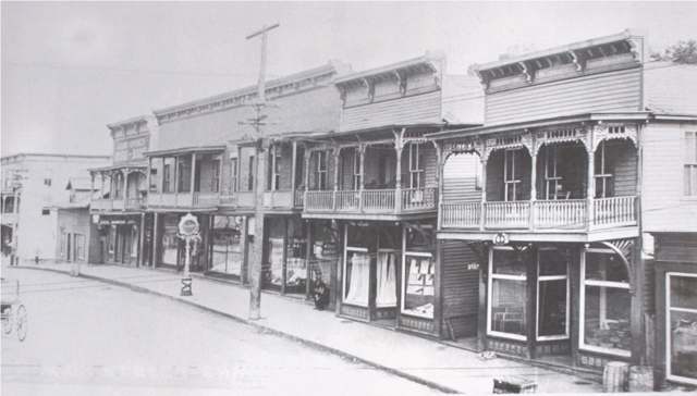
Photo: ssobachek, via Panoramio/Wikimedia Commons, CC BY-SA 3.0 · Wikimedia Commons
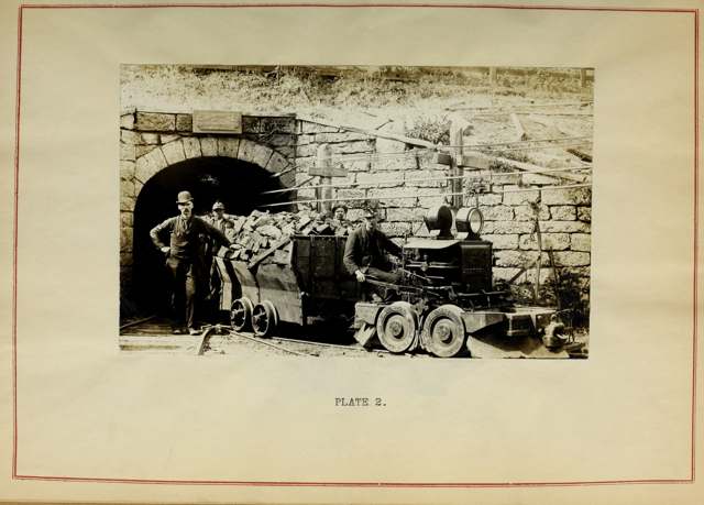
Photo: Bureau of Mines / Wikimedia Commons, no known copyright restrictions · Wikimedia Commons
Local history sources: en.wikipedia.org · archive.org · tecumsehtheater.org · commons.wikimedia.org · commons.wikimedia.org
Historic places
1 place in Shawnee on the National Register of Historic Places. Press a pin or a name for its whole record.
-
I.O. of R.M. BuildingBuilding · Shawnee · listed 1976
- Address
- Both sides of Main St., 2nd St. to Walnut St.
- Where
- Shawnee, Perry County · ZIP 43782
- What it is
- Building
- Listed on the National Register
- 1976
- NRIS reference number
- 76001507
- Coordinates
- 39.60411, -82.21236
National Register file (NPS) ↗ Search Wikipedia ↗ Street map and directions ↗ On the Cracked Buckeye map
Source: National Park Service, National Register of Historic Places point file. The listing year is shown where NPS's certification date agrees with the listing's reference number. Listing recognizes significance; it does not restrict a private owner.
Water
Six wells (4 MGD combined) in a sand-and-gravel aquifer in the Hocking River Buried Valley aquifer system, Dover Township, Athens County (2025 CCR). Ohio EPA's May 2012 source water assessment rates the source highly susceptible to contamination (thin clay cover, aquifer less than 20 ft deep). The water here
- Shawnee, Village Of100% of residentsHocking River Buried Valley Aquifer (wells)
Hospitals, fire stations and more
Inside Shawnee's boundary: 1 fire or EMS station and 1 spill case. Press a pin or a name for its whole record and its source.
Fire and EMS stations (1)
-
Shawnee Fire DepartmentShawnee
- Address
- 7970 Iron Point Road, Shawnee, OH 43782
- Coordinates
- 39.60486, -82.20547
USGS National Map structures (source) ↗ Street map and directions ↗
Source: USGS National Map structures (most Ohio records last updated 2019 to 2022), checked against the Columbus and Cleveland station lists. The department that answers a call is set by jurisdiction and mutual aid, not by distance.
Spills reported since 2021 (1)
-
Material White2025-05-04 · Shawnee
- Reported
- 2025-05-04
- What spilled
- Material White
- Where
- Shawnee, Perry County
- Ohio EPA district office
- SEDO
- Ohio EPA case number
- 2505EPA0000698
Ohio EPA spill reports (source) ↗ Street map and directions ↗
Source: Ohio EPA emergency response spill reports, 2021 to September 2026, one point per case where Ohio EPA placed it. A report is what the caller or responder recorded; amounts are often blank or estimated.
Its ZIP codes
Each ZIP code that touches Shawnee, with the share of its residents who live here and the same headline figures as the ZIP page.
Local government
Who holds office in Shawnee, how its elections and ballot issues came out, and the state auditor's record.
Auditor of State record
- No fiscal caution, watch or emergency on the Auditor of State's lists.
- Financial Audit, 2022 to 2023, released 2024-12-03
The county
Perry County: 11 ZIP codes, 26 cities, villages and townships, 38,855 people.
Nearby places
Rain and snow
How much has actually fallen on Shawnee, day by day, from 1887 to now. Daily totals, not averages.
- rain, last 30 days
- 1.39 in
- 2026-09-30 to 2026-10-29
- rain so far in 2026
- 47.2 in
- 10.9 in above normal for the date
- snow so far in 2026
- 16.3 in
- a normal year brings 16.4 in
- a normal year
- 42.7 in
- average of 30 years, 1991-2020
| Month | Rain (in) | Snow (in) | Days counted |
|---|---|---|---|
| October 2026 | 1.39 | — | 29 |
| September 2026 | 7.92 | — | 30 |
| August 2026 | 10.68 | — | 31 |
| July 2026 | 4.75 | — | 31 |
| June 2026 | 4.23 | — | 30 |
| May 2026 | 5.32 | — | 31 |
| April 2026 | 3.46 | — | 30 |
| March 2026 | 6.39 | 2.9 | 31 |
| February 2026 | 1.04 | 3.0 | 28 |
| January 2026 | 2.02 | 10.4 | 31 |
| December 2025 | 2.19 | 8.1 | 31 |
| November 2025 | 2.70 | 0.4 | 30 |
| Wettest year | 2018 — 60.3 in |
|---|---|
| Driest year | 1930 — 21.7 in |
| Snowiest year | 1960 — 56.0 in |
| Wettest day on record | 9 September 2004 — 4.27 in |
| Heaviest snowfall in a day | 14 January 1968 — 13.89 in |
| Deepest snow on the ground | 14 January 1968 — 21.63 in |
Estimated, not measured. No rain gauge has ever stood inside Shawnee, so every figure here is worked out from the gauges around it - the nearest ones weighted most. Treat them as close estimates rather than readings.
49,645 days of records, 1887-08-01 to 2026-10-29. Source: NOAA NCEI GHCN-Daily, 3,240 gauges in and around Ohio. A day is "gauged" when a gauge standing inside the boundary reported it, and the value is the mean of those gauges. Otherwise it is interpolated by inverse distance from every gauge reporting within 50 miles. Nothing is carried forward, back-filled or smoothed. Against NOAA nClimDiv county monthly precipitation over 136,848 complete county-months (checked 2026-10-31): correlation 0.9515, median absolute difference 0.217 in a month. Built 2026-10-31 from the Cracked Buckeye precipitation archive. Snow is the softer number — snowfall is measured by hand with a ruler, no agency publishes a gridded county snowfall series, and blowing snow defeats every observer.
Environmental permits and filings
What Ohio EPA has on file for Shawnee: permits, inspections, violations, cleanups and the state loans behind sewer and water work. Every line links to the agency's own document.
- facilities and sites on file
- 3
- those placed on the map inside Shawnee
| Program | Facilities and sites |
|---|---|
| State water loans | 2 |
| Wastewater and stormwater discharge | 1 |
| Date | Facility or site | What |
|---|---|---|
| BLACK DIAMOND TINY HOME VILLAGE | Wastewater and stormwater discharge inspection | |
| BLACK DIAMOND TINY HOME VILLAGE | Wastewater and stormwater discharge permit | |
| BLACK DIAMOND TINY HOME VILLAGE | Wastewater and stormwater discharge inspection | |
| BLACK DIAMOND TINY HOME VILLAGE | Wastewater and stormwater discharge permit | |
| SHAWNEE, VILLAGE OF | State water loans |
Source: Ohio EPA eDocument portal (edocpub.epa.ohio.gov), indexed 2026-10-14. Facilities are placed on the map from Ohio EPA's own map layers, EPA's Facility Registry, coordinates written in the filings, or a geocoded street address. A permit filed under a private person's name (most are household septic systems) is counted but never named, placed or linked; licenses for individual workers and open-burning notices are left out entirely.
Quick answers
What county is Shawnee, Ohio in?
Shawnee is a village in Perry County, Ohio, with 505 residents.
When was Shawnee, Ohio founded?
Shawnee was laid out 1872; incorporated 1874. Founders on record: T.J. Davis, on the former Israel Gordon farm. Source
How did Shawnee, Ohio get its name?
Named for the Shawnee people, whose village stood on Shawnee Run, the creek the town sits along in Salt Lick Township. Source
What ZIP code is Shawnee, Ohio?
Most of Shawnee is in ZIP code 43782.
Where does Shawnee, Ohio get its water?
The main water source for Shawnee (Shawnee, Village Of): Six wells (4 MGD combined) in a sand-and-gravel aquifer in the Hocking River Buried Valley aquifer system, Dover Township, Athens County (2025 CCR). Ohio EPA's May 2012 source water assessment rates the source highly susceptible to contamination (thin clay cover, aquifer less than 20 ft deep).
Cite this page
Cite this page as:
Cracked Buckeye, "Shawnee, Perry County", https://crackedbuckeye.com/place/shawnee/, built 2026-10-31, accessed [date].
How to cite · Report a correction · Built 2026-10-31
