Local events in Payne
Nothing is posted for Payne itself yet; here is what is on within 20 miles. All local events in Payne
Know a calendar we should watch? Send the link
Checked October 20; the events page is refreshed daily.
How Payne began
Payne was platted in 1872 as Flatrock City by W. C. Hedges of Tiffin along the line of the 'Continental' railroad then being graded, and was renamed Malottville after additions made in 1878 by James Malott and Peter Lehman. Its active growth began in 1882 with the Nickel Plate railroad, and it was incorporated in 1883 under the name Payne, the name of a post office that had existed in the neighborhood since 1858 and, according to Wikipedia, of Ohio senator Henry B. Payne. The 1892 county atlas places it in both Harrison and Benton townships, the larger part in Harrison, and by 1890 it had 1,146 residents and stave, hoop and lumber factories. It has held roughly 1,000 to 1,600 residents since the early twentieth century and today is served by the Wayne Trace Local School District and a branch of the Paulding County Library.
Platted 1872, incorporated 1883, by W. C. Hedges of Tiffin, surveyed by county surveyor Noah Ely.
Where the name comes from
Originally laid out as Flatrock City in 1872, for nearby Flat Rock Creek, before being renamed Payne in honor of Henry B. Payne (1810-1896), an Ohio US senator.
Before the town
No Native American village, mound, or treaty site specific to Payne is documented in the sources checked. The village sits in Benton Township, in the southeast of the county, away from the documented Ottawa Oquanoxa Reserve on the Auglaize River in Brown Township.
Timeline
- — A post office named Payne opens at the house of Adam Snellenberger, the first postmaster, on the mail route from Paulding to Monroeville, Indiana.
- — The community is laid out under the name Flatrock City.
- — Advertisements in the Paulding Democrat call the place 'Flatrock City' and promote a new grocery and a store paying cash for staves, hoop-poles and black-ash hoops.
- — James Malott and Peter Lehman make additions to the village, and the name changes from Flatrock to Malottville.
- — Payne's first large factory, the stave and lumber company of N. E. Prentice & Co., begins operations; in 1881 the name of the village of Malottville is changed to Payne to match the post office.
- — The Nickel Plate railroad is completed through the village, marking the start of its active growth; General W. H. Gibson of Tiffin makes an addition and builds several business rooms.
- — Payne is incorporated as a village under that name.
- — A frame school house with six departments is completed at a cost of about $3,500.
- — A fire on the night of September 15 sweeps away an entire block of frame buildings on the south side of Merrin Street; brick blocks replace them, and a fire department of about forty members is organized that spring with a hand engine bought at Seneca Falls, New York.
- — Henry Howe describes Payne, eight miles southwest of Paulding village on the New York, Chicago and St. Louis Railroad, as home to its own newspaper (the Review, Republican, edited by W. J. Johnson) and several manufacturers: N. E. Prentice's flour mill (9 hands), P. H. Hyman's lumber and stave works (18 hands), the Payne Hoop Co. (41 hands, the village's largest employer), H. F. Schnelker & Co.'s stave works (24 hands), Jacob Ream's lumber and flooring mill (10 hands), and Miller & Zind's wagon shop (3 hands); school census that year counts 354 pupils, capital invested in manufacturing totals $60,000, and the annual product is valued at $65,000.
- — The census gives Payne 1,146 residents, up from forty or fifty in 1880.
- — A fire about 1 a.m. destroys five frame business houses at Laura and Merrin streets, including a saloon, barber shop, photographer's gallery, a doctor's office and a meat market.
- — By this era the village, renamed Payne for Ohio senator Henry B. Payne, has a public school photographed for a postcard later held by the Columbus Metropolitan Library.
- — Payne's population peaks at 1,614 before falling sharply the following decade.
- — Population falls to 984, down from the 1930 peak.
- — The census records 1,192 residents.
Stories
From Flatrock City to a town of 1,146
In 1880 Payne was half a dozen houses and forty or fifty people; by the census of 1890 it had 1,146. W. C. Hedges of Tiffin platted it in 1872 as Flatrock City, with the surveying done by county surveyor Noah Ely, and in May 1874 the Paulding Democrat carried advertisements from its first grocery and a store that paid cash for staves, hoop-poles and black-ash hoops. After James Malott and Peter Lehman added to it in 1878 it was called Malottville, but the growth came with the Nickel Plate in 1882. Factories drove it: N. E. Prentice & Co. shipped more than 2,300,000 pail staves and 68,000 pail covers in a single year, the Payne Hoop Company could turn out 30,000 elm hoops a day, and lumber and stave mills filled out the rest. The village was incorporated in 1883, burned in 1887 and again in 1891, and rebuilt in brick each time.
Photographs
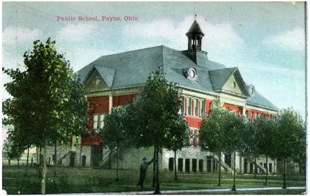
Photo: Columbus Metropolitan Library, via Digital Public Library of America and the Ohio Digital Network, public domain · Wikimedia Commons
Local history sources: en.wikipedia.org · en.wikipedia.org · commons.wikimedia.org · archive.org · archive.org
Water
Mostly private wells The water here
- Payne Village100% of residentsGroundwater wells (2 wells)
Hospitals, fire stations and more
Inside Payne's boundary: 1 fire or EMS station, 1 public school, 1 private school, 1 library and 1 police station. Press a pin or a name for its whole record and its source.
Fire and EMS stations (1)
-
Payne Volunteer Fire and Emergency Medical Services DepartmentPayne
- Address
- 202 North Laura Street, Payne, OH 45880
- Coordinates
- 41.08046, -84.72532
USGS National Map structures (source) ↗ Street map and directions ↗
Source: USGS National Map structures (most Ohio records last updated 2019 to 2022), checked against the Columbus and Cleveland station lists. The department that answers a call is set by jurisdiction and mutual aid, not by distance.
Public schools (1)
-
Payne Elementary School4 of 5 stars · Payne
- Address
- 501 W Townline St, Payne, OH 45880
- School district
- Wayne Trace Local School District
- Kind (NCES)
- Regular School
- Students, 2023-24
- 249
- Teachers (full-time equivalent)
- 19
- Report card, 2025-26
- 4 of 5 stars
- Performance index
- 82.2%
- Ohio building IRN
- 029462
- NCES school ID
- 390490303470
NCES school record ↗ Ohio School Report Card ↗ Street map and directions ↗
Source: NCES EDGE public school locations 2024-25 and Common Core of Data 2023-24 (type, students, teachers); Ohio School Report Cards 2025-26 (Department of Education and Workforce), matched by name within the district.
Private schools (1)
-
Divine Mercy SchoolPrivate, Catholic · Payne
- Address
- 120 Arturus St, Payne, OH 45880
- Kind
- Catholic
- Students, 2023-24
- 59
- Teachers (full-time equivalent)
- 7.8
- Students per teacher
- 7.5641
- Phone
- (419) 263-2114
- NCES private school ID
- 01061175
Source: NCES Private School Survey 2023-24.
Public libraries (1)
-
Payne BranchBranch · Payne
- Address
- 101 N Main St, Payne, OH 45880
- What it is
- Branch
- Library system
- Paulding County Carnegie Library
- Open
- 2,184 hours a year, 52 weeks
- Building
- 1,806 sq ft
- System's visits, FY2024
- 57,252
- System's loans, FY2024
- 230,430
- People the system serves
- 18,806
- Phone
- (419) 263-3333
IMLS Public Libraries Survey (source) ↗ Street map and directions ↗
Source: IMLS Public Libraries Survey FY2024 (outlets and their systems). Any Ohio resident can get a free card at any Ohio public library.
Police stations (1)
-
Payne Police DepartmentPayne
- Address
- 119 North Main Street, Payne, OH 45880
- Coordinates
- 41.07979, -84.72704
USGS National Map structures (source) ↗ Street map and directions ↗
Source: USGS National Map structures, police stations, corrected and completed by hand (September 2026). The department that answers a call is set by jurisdiction, not by distance.
Its ZIP codes
Each ZIP code that touches Payne, with the share of its residents who live here and the same headline figures as the ZIP page.
| ZIP | Share | Water | Radon | Home value | Schools | Flood |
|---|---|---|---|---|---|---|
| 45880 Payne | 47% | Mostly private wells | Too few radon tests | Appraisal records without year built | Wayne Trace Local · 3.5 stars overall | 13% of residents in the 1% floodplain |
Local government
Who holds office in Payne, how its elections and ballot issues came out, and the state auditor's record.
Money issues on the ballot since 2020: 6 of 7 passed; of those asking for new or higher taxes, 6 of 7.
Ballot issues
| Date | Issue | For | Against | Result |
|---|---|---|---|---|
| 2023-11-07 | Issue 5: Proposed Tax Levy (Additional) - Benton Township / Village of Payne | 161 | 231 | Failed (41.07% for) |
| 2023-11-07 | Issue 16: Proposed Tax Levy (Replacement) - Payne Village | 210 | 116 | Passed (64.42% for) |
| 2022-11-08 | Issue: Proposed Tax Levy (Replacement) - Payne Village, 1 mill, fire, 2023 (1.0 mills, replacement) | 237 | 123 | Passed (65.83% for) |
| 2022-11-08 | Issue: Proposed Tax Levy (Replacement) - Payne Village, 1 mill, police, 2023 (1.0 mills, replacement) | 238 | 124 | Passed (65.75% for) |
| 2021-11-02 | 9: 9 Proposed Tax Levy - Payne Village, replacement, current expenses, 3 mills, 5 yrs, 2022-2026 (3.0 mills, replacement) | 161 | 93 | Passed (63.39% for) |
| 2021-11-02 | 10: 10 Proposed Tax Levy - Payne Village, replacement, police, 1 mill, 5 yrs, 2022-2026 (1.0 mills, replacement) | 132 | 120 | Passed (52.38% for) |
| 2020-11-03 | 9: 9 Proposed Tax Levy (Replacement, 1 mill, 5 yrs, 2021-2025, Police) Payne Village (1.0 mills, replacement) | 335 | 223 | Passed (60.04% for) |
Elections for office
| Date | Office | Candidates and votes |
|---|---|---|
| 2023-11-07 | Member of Board of Public Affairs | Ray H. Speice 205, 47.02%; Allen Wobler 231, 52.98% |
| 2021-11-02 | Member of Council | Priscilla M. Kadolph 109, 13.76%; Lora A. Lyons 199, 25.13%; Nancy L. Speice 160, 20.2%; Allen Wobler 162, 20.45%; Jennifer Zartman 162, 20.45% |
| 2021-11-02 | Member of Board of Public Affairs | Jarrod Childs 191, 100.0% |
| 2021-11-02 | Mayor | Parker Martin 70, 28.0%; Austin T. Scheiner 180, 72.0% |
| 2019-11-05 | Member of Council | Lyn A. Collis 125, 23.19%; Austin T. Scheiner 135, 25.05%; Nancy L. Speice 132, 24.49%; Kevin A. Wannemacher 147, 27.27% |
| 2019-11-05 | Mayor | Matt Reighter 106, 36.3%; Steven Wobler 186, 63.7% |
| 2015-11-03 | Mayor | Matt Reighter 8, 2.02%; Ronald E. Schoenauer 107, 26.95%; Jim Wilson 60, 15.11%; Steve Wobler 222, 55.92% |
| 2015-11-03 | Council | Steve Crowley 269, 50.37%; Austin T. Scheiner 265, 49.63% |
Winners in bold. Results from the county board of elections' official canvass unless marked.
Auditor of State record
- No fiscal caution, watch or emergency on the Auditor of State's lists.
- Financial Audit, 2022 to 2023, released 2024-10-15
The county
Paulding County: 9 ZIP codes, 21 cities, villages and townships, 17,637 people.
Nearby places
Rain and snow
How much has actually fallen on Payne, day by day, from 1893 to now. Daily totals, not averages.
- rain, last 30 days
- 0.93 in
- 2026-09-30 to 2026-10-29
- rain so far in 2026
- 36.5 in
- 3.8 in above normal for the date
- snow so far in 2026
- 14.4 in
- a normal year brings 26.3 in
- a normal year
- 38.0 in
- average of 30 years, 1991-2020
| Month | Rain (in) | Snow (in) | Days counted |
|---|---|---|---|
| October 2026 | 0.93 | — | 29 |
| September 2026 | 5.46 | — | 30 |
| August 2026 | 6.57 | — | 31 |
| July 2026 | 3.44 | — | 31 |
| June 2026 | 3.09 | — | 30 |
| May 2026 | 3.19 | — | 31 |
| April 2026 | 7.96 | — | 30 |
| March 2026 | 3.73 | 0.7 | 31 |
| February 2026 | 0.69 | 3.0 | 28 |
| January 2026 | 1.41 | 10.7 | 31 |
| December 2025 | 1.41 | 5.2 | 31 |
| November 2025 | 1.75 | 8.1 | 30 |
| Wettest year | 1950 — 52.2 in |
|---|---|
| Driest year | 1962 — 24.8 in |
| Snowiest year | 2014 — 61.7 in |
| Wettest day on record | 21 August 2007 — 4.50 in |
| Heaviest snowfall in a day | 28 February 1900 — 12.01 in |
| Deepest snow on the ground | 9 February 1982 — 21.19 in |
Estimated, not measured. No rain gauge has ever stood inside Payne, so every figure here is worked out from the gauges around it - the nearest ones weighted most. Treat them as close estimates rather than readings.
48,358 days of records, 1893-01-01 to 2026-10-29. Source: NOAA NCEI GHCN-Daily, 3,240 gauges in and around Ohio. A day is "gauged" when a gauge standing inside the boundary reported it, and the value is the mean of those gauges. Otherwise it is interpolated by inverse distance from every gauge reporting within 50 miles. Nothing is carried forward, back-filled or smoothed. Against NOAA nClimDiv county monthly precipitation over 136,848 complete county-months (checked 2026-10-31): correlation 0.9515, median absolute difference 0.217 in a month. Built 2026-10-31 from the Cracked Buckeye precipitation archive. Snow is the softer number — snowfall is measured by hand with a ruler, no agency publishes a gridded county snowfall series, and blowing snow defeats every observer.
Environmental permits and filings
What Ohio EPA has on file for Payne: permits, inspections, violations, cleanups and the state loans behind sewer and water work. Every line links to the agency's own document.
- facilities and sites on file
- 8
- those placed on the map inside Payne
| Program | Facilities and sites |
|---|---|
| Air pollution | 2 |
| Contaminated-site cleanup | 1 |
| Hazardous waste | 1 |
| Public drinking water | 1 |
| Sewer and water-line construction | 1 |
| State sewer loans | 1 |
| Wastewater and stormwater discharge | 1 |
| Date | Facility or site | What |
|---|---|---|
| PLEASANT VALLEY GOLF COURSE PWS | Public drinking water notice of violation | |
| PLEASANT VALLEY GOLF COURSE PWS | Public drinking water inspection | |
| PLEASANT VALLEY GOLF COURSE PWS | Public drinking water inspection | |
| PLEASANT VALLEY GOLF COURSE PWS | Public drinking water notice of violation | |
| PLEASANT VALLEY GOLF COURSE PWS | Public drinking water notice of violation | |
| PLEASANT VALLEY GOLF COURSE PWS | Public drinking water inspection | |
| PLEASANT VALLEY GOLF COURSE PWS | Public drinking water inspection | |
| PLEASANT VALLEY GOLF COURSE PWS | Public drinking water inspection | |
| PLEASANT VALLEY GOLF COURSE PWS | Public drinking water notice of violation | |
| VILLAGE OF PAYNE- EVERGREEN ACRES SUBDIVISION | Sewer and water-line construction permit | |
| VILLAGE OF PAYNE- EVERGREEN ACRES SUBDIVISION | Wastewater and stormwater discharge permit | |
| VILLAGE OF PAYNE- EVERGREEN ACRES SUBDIVISION | Sewer and water-line construction permit | |
| PLEASANT VALLEY GOLF COURSE PWS | Public drinking water director's orders | |
| PLEASANT VALLEY GOLF COURSE PWS | Public drinking water monitoring results | |
| PLEASANT VALLEY GOLF COURSE PWS | Public drinking water inspection | |
| PLEASANT VALLEY GOLF COURSE PWS | Public drinking water notice of violation | |
| PLEASANT VALLEY GOLF COURSE PWS | Public drinking water notice of violation | |
| PLEASANT VALLEY GOLF COURSE PWS | Public drinking water notice of violation | |
| PLEASANT VALLEY GOLF COURSE PWS | Public drinking water notice of violation | |
| PLEASANT VALLEY GOLF COURSE PWS | Public drinking water notice of violation | |
| PLEASANT VALLEY GOLF COURSE PWS | Public drinking water monitoring results | |
| PLEASANT VALLEY GOLF COURSE PWS | Public drinking water inspection | |
| PLEASANT VALLEY GOLF COURSE PWS | Public drinking water inspection | |
| PLEASANT VALLEY GOLF COURSE PWS | Public drinking water inspection | |
| PLEASANT VALLEY GOLF COURSE PWS | Public drinking water notice of violation |
Source: Ohio EPA eDocument portal (edocpub.epa.ohio.gov), indexed 2026-10-14. Facilities are placed on the map from Ohio EPA's own map layers, EPA's Facility Registry, coordinates written in the filings, or a geocoded street address. A permit filed under a private person's name (most are household septic systems) is counted but never named, placed or linked; licenses for individual workers and open-burning notices are left out entirely.
Quick answers
What county is Payne, Ohio in?
Payne is a village in Paulding County, Ohio, with 1,127 residents.
When was Payne, Ohio founded?
Payne was laid out 1872; incorporated 1883. Founders on record: W. C. Hedges of Tiffin, surveyed by county surveyor Noah Ely. Source
How did Payne, Ohio get its name?
Originally laid out as Flatrock City in 1872, for nearby Flat Rock Creek, before being renamed Payne in honor of Henry B. Source
What ZIP code is Payne, Ohio?
Most of Payne is in ZIP code 45880.
Where does Payne, Ohio get its water?
The main water source for Payne (Payne Village): Mostly private wells.
Cite this page
Cite this page as:
Cracked Buckeye, "Payne, Paulding County", https://crackedbuckeye.com/place/payne/, built 2026-10-31, accessed [date].
How to cite · Report a correction · Built 2026-10-31
