Local events in Mount Cory
Nothing is posted for Mount Cory itself yet; here is what is on within 20 miles. All local events in Mount Cory
Know a calendar we should watch? Send the link
Checked October 20; the events page is refreshed daily.
How Mount Cory began
Mount Cory, in Union Township, was laid out in July 1872 by Matthias Markley and Samuel Kemerer as the railroad reached the site and was first called Cory, in honor of D. J. Cory of Findlay; its post office, opened in 1873, was named Mount Cory. The village's population peaked at 334 in 1890 and declined by nearly forty percent over the following century, bottoming out around 203 in 2000 before a modest recovery to 225 by the 2020 census. Mount Cory remains a small rail-era village in western Hancock County today, governed by an elected village council.
Platted 1872-07-18, as Cory, by Matthias Markley and Samuel Kemerer, on the Lake Erie & Western Railroad; named for D. J. Cory of Findlay.
Where the name comes from
Named Cory in honor of D. J. Cory, Esq., of Findlay, when the railroad town was laid out in 1872 (the 1881 county history says it was named in his honor; it names Matthias Markley and Samuel Kemerer as the men who laid it out). The 1881 history gives the post office as Mount Cory in 1873; no source consulted says why 'Mount' was added.
Before the town
No named Native village, mound or treaty reserve specific to the site of Mount Cory was found. The stream beside the village is Ottawa Creek (spelled 'Tawa Creek' in places in the 1881 county history), a name that echoes the Ottawa (Odawa) of the Blanchard's Fork Reserve and its Upper and Lower Tawa Towns along the Blanchard River at present Findlay, but no source ties the creek's name to a village or camp on it. The township itself was erected in 1832, the year after the Ottawa ceded the Blanchard's Fork lands in 1831.
Nations recorded here: Ottawa (Odawa).
Timeline
- — Philip Cramer, a Fairfield County man, visits Hancock County and enters the east half of Section 1 of what becomes Union Township; he moves his family there the next month, the township's first settlers, and builds a horse-mill in 1832.
- — Jacob Burket marries Sarah Cramer, daughter of Philip Cramer Sr., the first marriage in Union Township; John Cramer, the first justice, performs it.
- — The Hancock County commissioners erect Union Township from Liberty Township on June 4; Philip Cramer, Nicholas Folk and George Burket are the first trustees.
- — Union Township has 637 inhabitants; it grows to 1,150 in 1850, 1,604 in 1860 and 1,876 in 1880 as the swamp is drained.
- — Matthias Markley and Samuel Kemerer lay out Cory on July 18 in Sections 22, 27 and 28 on the line of the Lake Erie and Western Railroad, then under construction; it lies about two and a half miles southwest of Rawson and is named for D. J. Cory of Findlay.
- — A flouring mill by Dr. H. P. Eaton and a sawmill by William D. Turner give the town its real start; a post office named Mount Cory opens with Benjamin Wildemuth as postmaster.
- — Hall and Harpster open a general store in February, followed by the Falks and by Dr. E. P. Leslie, the first resident physician, who opens a drug store.
- — Mount Cory has 199 people, and by 1881 claims nearly 300, with two general stores, a hardware store, a hotel and livery, a flouring mill, a tile factory, a two-teacher brick school and Evangelical Association and Methodist Protestant churches.
- — The village's population peaks at 334 residents.
- — Population has fallen to 203, roughly a 39% decline from the 1890 peak.
- — The census records 225 residents, a modest recovery from the 2000 low.
Stories
Two men lay out a town and borrow a Findlay name
On July 18, 1872, with the Lake Erie & Western Railroad pushing across the open farmland of Union Township, Matthias Markley and Samuel Kemerer laid out a town on parts of Sections 22, 27 and 28 and named it Cory, for D. J. Cory of Findlay, whom the same history elsewhere calls Judge Cory. A few buildings went up that fall when the rails arrived, but the village really began in 1873, when Dr. H. P. Eaton built a flouring mill and William D. Turner a sawmill. The post office that opened the same year already carried the longer name Mount Cory, with Benjamin Wildemuth as postmaster. In February 1874 Hall and Harpster opened a general store, the Falk family brought in a stock of goods, and Dr. E. P. Leslie became the first resident physician with a drug store. By 1880 the village counted 199 people, and the county's 1881 historian called it 'a stirring little village' that added considerably to the wealth of its township. It peaked at 334 in 1890 and has since settled near 200.
Photographs
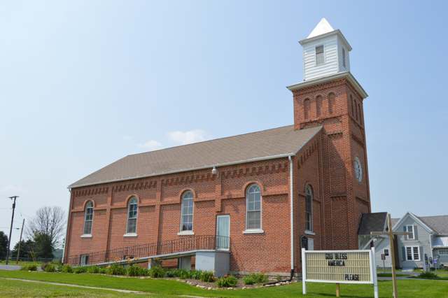
Photo: Nyttend, Public domain · Wikimedia Commons
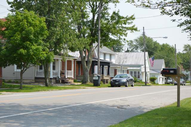
Photo: Nyttend, Public domain · Wikimedia Commons
Local history sources: en.wikipedia.org · commons.wikimedia.org · commons.wikimedia.org · archive.org · en.wikipedia.org
Water
No water-system data is linked to Mount Cory's ZIP codes yet.
Hospitals, fire stations and more
Inside Mount Cory's boundary: 1 fire or EMS station. Press a pin or a name for its whole record and its source.
Fire and EMS stations (1)
-
Union Township Mount Cory Volunteer Fire DepartmentMount Cory
- Address
- 111 South Main Street, Mount Cory, OH 45868
- Coordinates
- 40.93349, -83.82318
USGS National Map structures (source) ↗ Street map and directions ↗
Source: USGS National Map structures (most Ohio records last updated 2019 to 2022), checked against the Columbus and Cleveland station lists. The department that answers a call is set by jurisdiction and mutual aid, not by distance.
Its ZIP codes
Each ZIP code that touches Mount Cory, with the share of its residents who live here and the same headline figures as the ZIP page.
| ZIP | Share | Water | Radon | Home value | Schools | Flood |
|---|---|---|---|---|---|---|
| 45868 Union Township and Mount Cory | 32% | Mostly private wells | 3.5 pCi/L average radon | Parcel list only | Cory-Rawson Local · 3 stars overall | 2.0% of residents in the 1% floodplain |
Local government
Who holds office in Mount Cory, how its elections and ballot issues came out, and the state auditor's record.
Auditor of State record
- No fiscal caution, watch or emergency on the Auditor of State's lists.
- Basic Audit, 2023 to 2024, released 2025-09-09
The county
Hancock County: 12 ZIP codes, 26 cities, villages and townships, 68,477 people.
Nearby places
Rain and snow
How much has actually fallen on Mount Cory, day by day, from 1893 to now. Daily totals, not averages.
- rain, last 30 days
- 0.88 in
- 2026-09-29 to 2026-10-28
- rain so far in 2026
- 33.9 in
- about normal for the date
- snow so far in 2026
- 13.9 in
- a normal year brings 27.2 in
- a normal year
- 37.9 in
- average of 30 years, 1991-2020
| Month | Rain (in) | Snow (in) | Days counted |
|---|---|---|---|
| October 2026 | 0.88 | — | 28 |
| September 2026 | 4.52 | — | 30 |
| August 2026 | 5.15 | — | 31 |
| July 2026 | 3.33 | — | 31 |
| June 2026 | 4.12 | — | 30 |
| May 2026 | 4.32 | — | 31 |
| April 2026 | 5.68 | — | 30 |
| March 2026 | 4.19 | 0.6 | 31 |
| February 2026 | 0.48 | 3.5 | 28 |
| January 2026 | 1.18 | 9.9 | 31 |
| December 2025 | 1.74 | 7.8 | 31 |
| November 2025 | 1.24 | 3.5 | 30 |
| Wettest year | 2011 — 53.4 in |
|---|---|
| Driest year | 1963 — 23.8 in |
| Snowiest year | 1895 — 71.5 in |
| Wettest day on record | 21 August 2007 — 4.37 in |
| Heaviest snowfall in a day | 12 January 1895 — 15.26 in |
| Deepest snow on the ground | 2 March 1912 — 21.52 in |
Estimated, not measured. No rain gauge has ever stood inside Mount Cory, so every figure here is worked out from the gauges around it - the nearest ones weighted most. Treat them as close estimates rather than readings.
48,878 days of records, 1893-01-01 to 2026-10-28. Source: NOAA NCEI GHCN-Daily, 3,240 gauges in and around Ohio. A day is "gauged" when a gauge standing inside the boundary reported it, and the value is the mean of those gauges. Otherwise it is interpolated by inverse distance from every gauge reporting within 50 miles. Nothing is carried forward, back-filled or smoothed. Against NOAA nClimDiv county monthly precipitation over 136,848 complete county-months (checked 2026-10-31): correlation 0.9515, median absolute difference 0.217 in a month. Built 2026-10-31 from the Cracked Buckeye precipitation archive. Snow is the softer number — snowfall is measured by hand with a ruler, no agency publishes a gridded county snowfall series, and blowing snow defeats every observer.
Environmental permits and filings
What Ohio EPA has on file for Mount Cory: permits, inspections, violations, cleanups and the state loans behind sewer and water work. Every line links to the agency's own document.
- facilities and sites on file
- 2
- those placed on the map inside Mount Cory
| Program | Facilities and sites |
|---|---|
| Public drinking water | 2 |
Source: Ohio EPA eDocument portal (edocpub.epa.ohio.gov), indexed 2026-10-14. Facilities are placed on the map from Ohio EPA's own map layers, EPA's Facility Registry, coordinates written in the filings, or a geocoded street address. A permit filed under a private person's name (most are household septic systems) is counted but never named, placed or linked; licenses for individual workers and open-burning notices are left out entirely.
Quick answers
What county is Mount Cory, Ohio in?
Mount Cory is a village in Hancock County, Ohio, with 225 residents.
When was Mount Cory, Ohio founded?
Mount Cory was laid out 1872-07-18, as Cory. Founders on record: Matthias Markley and Samuel Kemerer, on the Lake Erie & Western Railroad; named for D. J. Cory of Findlay. Source
How did Mount Cory, Ohio get its name?
Named Cory in honor of D. Source
What ZIP code is Mount Cory, Ohio?
Most of Mount Cory is in ZIP code 45868.
Where does Mount Cory, Ohio get its water?
The main water source for Mount Cory: Mostly private wells.
Cite this page
Cite this page as:
Cracked Buckeye, "Mount Cory, Hancock County", https://crackedbuckeye.com/place/mount-cory/, built 2026-10-31, accessed [date].
How to cite · Report a correction · Built 2026-10-31
