Local events in Midland
Nothing is posted for Midland itself yet; here is what is on within 20 miles. All local events in Midland
Know a calendar we should watch? Send the link
Checked October 20; the events page is refreshed daily.
How Midland began
Midland sits in the northwestern corner of Jefferson Township in southwestern Clinton County, on Ohio Route 28 near U.S. Route 68, twelve miles from Wilmington. It was originally laid out as Clinton Valley and grew up as a station on the Marietta and Cincinnati line, later the Baltimore and Ohio, known as a coaling and water stop that gave work to a number of railroad men. The 1882 county history still calls it Clinton Valley; by the 1915 history it is Midland City, later shortened to Midland. Jefferson Township itself was organized in 1839 out of Clark and Marion townships; Midland's population has stayed small and stable, standing at 307 at the 2020 census against a 1970 peak of 388.
Where the name comes from
Wikipedia says only that Midland was originally called Clinton Valley. The 1882 county history calls it Clinton Valley; the 1915 county history calls it Midland City and says it 'was first laid out as Clinton Valley.' No source gives the date of the change or the reason for either name.
Before the town
No Native American village, camp, mound, or named leader is recorded within Midland or Jefferson Township. Jefferson Township lies entirely within the Virginia Military District, land surveyed for Revolutionary War veterans after the 1795 Treaty of Greenville opened the area south and east of the treaty line to settlement. The 2003 'Indian Trails of Clinton County' marker in Wilmington documents the Bullskin Trace, used as a trade route to the French at Detroit, running through western Clinton County along the line of today's SR 132 and 380 and George and Mound Roads, the western part of the county where Jefferson Township sits; its path through Jefferson Township or Midland itself is not recorded, so it is a county-scale lead, not a site-specific claim.
Nations recorded here: Shawnee, Myaamia (Miami), Lenape (Delaware).
Timeline
- — Jefferson Township, in which Midland sits, is organized by the Clinton County commissioners out of land taken from Clark and Marion townships and named for Thomas Jefferson.
- — A tornado strikes Jefferson Township, tearing up timber and unroofing buildings and blowing down part of the brick school and the Methodist church at nearby Westboro.
- — Jefferson Township, which holds Clinton Valley, has 1,448 residents in the census.
- — Clinton Valley, on the Marietta Railroad at the crossing of the Wilmington and Westboro free turnpike twelve miles from Wilmington, is a coaling and water station with about 100 people, two stores, a steam sawmill and a brick schoolhouse.
- — The community first laid out as Clinton Valley is by now called Midland City, later shortened to Midland; the 1882 county history still uses Clinton Valley and the 1915 history uses Midland City.
- — Midland's population is recorded at 328.
- — The 1915 county history describes Midland City as incorporated, with about 400 people, stores, a hotel, a livery and cement-block makers, and served by the Baltimore and Ohio Midland division as well as the main line.
- — Midland's population peaks at 388.
- — Midland's population falls from 319 to 265 over the decade before partially rebounding.
- — The U.S. Census records Midland's population at 307.
Stories
From Clinton Valley to a railroad coaling stop
Midland began as Clinton Valley. The 1882 Clinton County history describes it as a station on the Marietta railroad at the crossing of the Wilmington and Westboro free turnpike, twelve miles from Wilmington, 'noted for being a great coaling and water station' that gave employment to a number of men, with about 100 people, two stores, a steam sawmill and a brick schoolhouse. By the time of the 1915 history the place was called Midland City, still noted as a coaling and water station of the Baltimore and Ohio, now with about 400 people and its own town officers; the name was later shortened to Midland. No source gives the date of the renaming.
Photographs
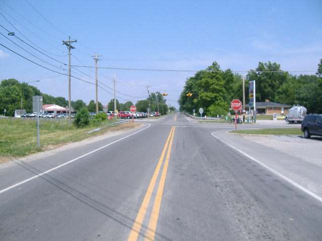
Photo: Aesopposea, CC BY-SA 3.0 · Wikimedia Commons
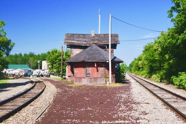
Photo: Brian Stansberry, CC BY 4.0 · Wikimedia Commons
Local history sources: en.wikipedia.org · en.wikipedia.org · en.wikipedia.org · en.wikipedia.org · remarkableohio.org · hmdb.org · commons.wikimedia.org · commons.wikimedia.org · archive.org · archive.org
Water
No water-system data is linked to Midland's ZIP codes yet.
Hospitals, fire stations and more
Inside Midland's boundary: 1 fire or EMS station and 1 spill case. Press a pin or a name for its whole record and its source.
Fire and EMS stations (1)
-
Clinton South Joint Fire DistrictMidland
- Address
- 111 South Broadway Street, Midland, OH 45148
- Coordinates
- 39.30440, -83.90998
USGS National Map structures (source) ↗ Street map and directions ↗
Source: USGS National Map structures (most Ohio records last updated 2019 to 2022), checked against the Columbus and Cleveland station lists. The department that answers a call is set by jurisdiction and mutual aid, not by distance.
Spills reported since 2021 (1)
-
Fuel Diesel / Diesel Fuel (Vehicle On Or Off Road)2023-04-25 · Midland
- Reported
- 2023-04-25
- What spilled
- Fuel Diesel / Diesel Fuel (Vehicle On Or Off Road)
- Where
- Midland, Clinton County
- Ohio EPA district office
- SWDO
- Ohio EPA case number
- 2304EPA0000668
Ohio EPA spill reports (source) ↗ Street map and directions ↗
Source: Ohio EPA emergency response spill reports, 2021 to September 2026, one point per case where Ohio EPA placed it. A report is what the caller or responder recorded; amounts are often blank or estimated.
Its ZIP codes
Each ZIP code that touches Midland, with the share of its residents who live here and the same headline figures as the ZIP page.
| ZIP | Share | Water | Radon | Home value | Schools | Flood |
|---|---|---|---|---|---|---|
| 45148 Jefferson Township and Midland | 20% | Mostly private wells | 3.8 pCi/L average radon | Median year built 1981 | Blanchester Local · 4.5 stars overall | 0.1% of residents in the 1% floodplain |
Local government
Who holds office in Midland, how its elections and ballot issues came out, and the state auditor's record.
Auditor of State record
- Fiscal emergency: declared 2006-11-30, released 2013-05-14. source
- Basic Audit, 2023 to 2024, released 2025-05-08
The county
Clinton County: 9 ZIP codes, 21 cities, villages and townships, 47,594 people.
Nearby places
Rain and snow
How much has actually fallen on Midland, day by day, from 1893 to now. Daily totals, not averages.
- rain, last 30 days
- 0.81 in
- 2026-09-30 to 2026-10-29
- rain so far in 2026
- 44.6 in
- 6.5 in above normal for the date
- snow so far in 2026
- 17.7 in
- a normal year brings 22.5 in
- a normal year
- 44.9 in
- average of 30 years, 1991-2020
| Month | Rain (in) | Snow (in) | Days counted |
|---|---|---|---|
| October 2026 | 0.81 | — | 29 |
| September 2026 | 7.05 | — | 30 |
| August 2026 | 7.01 | — | 31 |
| July 2026 | 4.12 | — | 31 |
| June 2026 | 5.55 | — | 30 |
| May 2026 | 5.58 | — | 31 |
| April 2026 | 4.22 | — | 30 |
| March 2026 | 7.69 | 0.6 | 31 |
| February 2026 | 1.08 | 6.1 | 28 |
| January 2026 | 1.44 | 11.0 | 31 |
| December 2025 | 2.86 | 11.1 | 31 |
| November 2025 | 3.81 | 3.1 | 30 |
| Wettest year | 2011 — 59.9 in |
|---|---|
| Driest year | 1901 — 24.5 in |
| Snowiest year | 1926 — 50.1 in |
| Wettest day on record | 6 October 1910 — 4.48 in |
| Heaviest snowfall in a day | 17 February 1910 — 10.00 in |
| Deepest snow on the ground | 21 January 1978 — 21.28 in |
Estimated, not measured. No rain gauge has ever stood inside Midland, so every figure here is worked out from the gauges around it - the nearest ones weighted most. Treat them as close estimates rather than readings.
48,874 days of records, 1893-01-01 to 2026-10-29. Source: NOAA NCEI GHCN-Daily, 3,240 gauges in and around Ohio. A day is "gauged" when a gauge standing inside the boundary reported it, and the value is the mean of those gauges. Otherwise it is interpolated by inverse distance from every gauge reporting within 50 miles. Nothing is carried forward, back-filled or smoothed. Against NOAA nClimDiv county monthly precipitation over 136,848 complete county-months (checked 2026-10-31): correlation 0.9515, median absolute difference 0.217 in a month. Built 2026-10-31 from the Cracked Buckeye precipitation archive. Snow is the softer number — snowfall is measured by hand with a ruler, no agency publishes a gridded county snowfall series, and blowing snow defeats every observer.
Environmental permits and filings
What Ohio EPA has on file for Midland: permits, inspections, violations, cleanups and the state loans behind sewer and water work. Every line links to the agency's own document.
- facilities and sites on file
- 1
- those placed on the map inside Midland
| Program | Facilities and sites |
|---|---|
| Hazardous waste | 1 |
Source: Ohio EPA eDocument portal (edocpub.epa.ohio.gov), indexed 2026-10-14. Facilities are placed on the map from Ohio EPA's own map layers, EPA's Facility Registry, coordinates written in the filings, or a geocoded street address. A permit filed under a private person's name (most are household septic systems) is counted but never named, placed or linked; licenses for individual workers and open-burning notices are left out entirely.
Quick answers
What county is Midland, Ohio in?
Midland is a village in Clinton County, Ohio, with 307 residents.
How did Midland, Ohio get its name?
Wikipedia says only that Midland was originally called Clinton Valley. Source
What ZIP code is Midland, Ohio?
Most of Midland is in ZIP code 45148.
Where does Midland, Ohio get its water?
The main water source for Midland: Mostly private wells.
Cite this page
Cite this page as:
Cracked Buckeye, "Midland, Clinton County", https://crackedbuckeye.com/place/midland/, built 2026-10-31, accessed [date].
How to cite · Report a correction · Built 2026-10-31
