How Eden Township, Licking County began
Eden Township was organized in 1822 out of territory that had belonged to Mary Ann Township, and settled the spring before by William Shannon, Jesse Oldaker and Ebenezer Brown, who each brought their families into its western half in 1813. Cut by the Rocky Fork into narrow, fertile valleys between rugged, rock-studded hills, the township took its biblical name from land the 1881 county history calls "a perfect Garden of Eden for the hunter both red and white," rich with game and scenery it still describes today at landmarks called Picture Rocks, Rain Rock and Pulpit Rock. No village ever took hold here -- an 1856 attempt at a town called Oberlin never even secured a post office -- leaving Eden, then as now, a township of farms and churches. Its best-documented landmark is not a building but a bridge: the Falling Rock Camp Bridge, a rare iron Post-truss span moved to the Rocky Fork here in 1931, one of only three of its kind known to survive in the United States.
Settled 1813 (William Shannon, Jesse Oldaker and Ebenezer Brown, in the township's west half), incorporated 1822, organized out of Mary Ann Township.
Where the name comes from
No source consulted states directly why the township was named Eden, but the 1881 county history's own description of the land -- "in its primitive condition... this township must have been a perfect Garden of Eden for the hunter both red and white," full of game that lingered here "long after it was driven out of the more desirable parts of the county" -- strongly suggests the name was meant to evoke exactly that abundance and wildness.
Before the town
The 1881 county history states that if the Mound Builders ever built works in Eden Township they have almost entirely disappeared, attributing this to the township's rocky, clay soil, which it says this "mysterious people" avoided in favor of sandy, loamy ground elsewhere. "No Indian history has been handed down," the same source continues, "but tradition has it that the Indians encamped on the Bowling Green used this as a hunting ground" -- a reference to Indian encampments recorded in neighboring Bowling Green Township, not to any camp inside Eden itself. No village, trail, or burial site specific to Eden Township was found in any source consulted. The land was ceded, along with the rest of Licking County, by the Treaty of Greenville of August 3, 1795.
Nations recorded here: Wyandot, Shawnee, Lenape (Delaware), Miami, Ottawa.
Timeline
- — The Treaty of Greenville cedes most of what becomes Ohio, including the future Eden Township, to the United States.
- — William Shannon, Jesse Oldaker and Ebenezer Brown settle in the western half of the future township, forming its nucleus.
- — The Pleasant Valley United Brethren church, on the old State road (later the Newark and Martinsburgh road) in the southern part of the township, organizes; it is among the oldest churches in the county.
- — Eden Township is organized out of territory that had been part of Mary Ann Township.
- — Elder James Porter organizes a Disciples of Christ congregation at the "Henthorn schoolhouse," the first Disciples church organized anywhere in Licking County.
- — The Disciples congregation builds a frame church on the line between Knox and Licking counties, on the farm of Benjamin Bell.
- — Walter B. Finney erects a woolen factory on the Rocky Fork about a mile below the Mitchell grist mill; it burns down after about seven years in operation.
- — James Shannon attempts to found a town called Oberlin in the northwest part of the township, building a store, but the settlement never grows beyond a handful of buildings and never secures its own post office.
- — James W. Colville establishes the township's second post office, called Long Run, in his own dwelling house.
- — An iron Post-truss bridge is built over Brushy Fork Creek in neighboring Perry Township; it is later moved to Hebron in 1927 and then, in 1931, to Falling Rock Camp on Eden Township's own Rocky Fork.
- — The Historic American Engineering Record photographs the Falling Rock Camp Bridge near Hickman, documenting it as a rare surviving composite cast- and wrought-iron Post truss.
Stories
A Township Without a Town
By the 1881 county history's own account, Eden Township never managed to raise a real village. Around 1856, James Shannon tried, building a store on the Rocky Fork near a small lake in the northwest part of the township and naming his prospective town Oberlin; he stocked the shelves, and attempts were made to secure a regular post office, but none ever came through, and letters for the neighborhood were simply left at the store. The building burned in 1880 and was rebuilt, and by 1881 the whole of "Oberlin" amounted to the store, a blacksmith shop, and three or four houses. A second store had briefly existed twenty years earlier on Elzey Dush's farm in the eastern part of the township, with a small cluster of its own houses, but that too came to nothing. "It has been stated that there were no villages in this township," the history concludes dryly, "and this is, probably, the case."
Rain Rock and Pulpit Rock
About a mile north of the township's south line, on the Rocky Fork, stand the "Picture rocks," wild enough to draw pleasure parties out from Newark. Further along, down a narrow by-road reachable only on foot, is Rain Rock: a huge, seamed sandstone shelf jutting some thirty or forty feet out over a gloomy, tree-filled gorge, high enough in places to shelter a hundred people from a storm, with spring water dripping constantly through its cracks -- freezing, in winter, into pillars of ice. In front of it stands a flat-topped boulder known as Pulpit Rock, used for open-air preaching and public meetings, with rude plank seats set up for the audience and a backdrop of riven, fern-rimmed cliffs that the 1881 history says looked, in season, "like an immense flower-pot." The whole scene, the same history says, made the spot "a very pretty and healthful resort."
A Bridge Twice Moved
The bridge that carries a service road over the Rocky Fork at Falling Rock Camp did not start out in Eden Township at all. Built in 1872 as an iron Post truss over Brushy Fork Creek in neighboring Perry Township, it was taken down and moved to Hebron in 1927, then moved again in 1931 to its present site on the Rocky Fork near Hickman. The Post truss -- an early and short-lived experimental design with cast-iron compression members -- proved rare enough that when the federal Historic American Engineering Record photographed the bridge in 1992, it was one of only three examples of the type known to survive anywhere in the country, and the only one left in Ohio.
Photographs
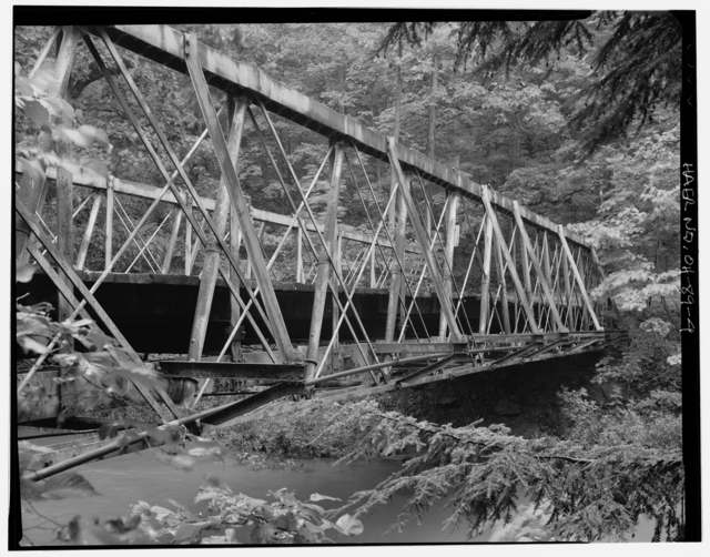
Photo: Joseph Elliott, Historic American Engineering Record, Library of Congress, public domain · Wikimedia Commons
Local history sources: archive.org · archive.org · en.wikipedia.org · en.wikipedia.org · oldohiobridges.com · commons.wikimedia.org
Water
Mostly private wells The water here
- St. Louisville Village63% of residentsGroundwater wells (2 wells)
- Utica Village36% of residentsGroundwater wells (2 wells)
- Martinsburg Village1% of residentsGroundwater wells (3 wells)
Its ZIP codes
Each ZIP code that touches Eden Township, Licking County, with the share of its residents who live here and the same headline figures as the ZIP page.
| ZIP | Share | Water | Radon | Home value | Schools | Flood |
|---|---|---|---|---|---|---|
| 43071 Eden Township and Saint Louisville | 41% | Mostly private wells | 14.8 pCi/L average radon | Median year built 1974 | North Fork Local · 3 stars overall | 0.9% of residents in the 1% floodplain |
| 43080 Utica | 4% | Mostly private wells | 16.1 pCi/L average radon | Median year built 1972 | North Fork Local · 3 stars overall | 6.9% of residents in the 1% floodplain |
The county
Licking County: 17 ZIP codes, 38 cities, villages and townships, 160,939 people.
Nearby places
Cite this page
Cite this page as:
Cracked Buckeye (Open Shower Co), "Eden Township, Licking County", https://crackedbuckeye.com/place/eden-township-licking-county/, built 2026-09-17, accessed [date].
Machine-readable: /api/place/eden-township-licking-county.json (open JSON, CC BY 4.0 for the compilation; the underlying records keep their own terms) · How to cite · Report a correction · Built 2026-09-17